Tim Lesser
This paper presents the GIS development and implementation of the City of Winston-Salem's infrastructure and technology enhancements to ArcSDE/Oracle and ArcIMS, and the deployment of a new City/County collaborative GIS web site. To facilitate the dissemination of geographic information for decision support and improvement of customer service, these advancements were deployed for the enterprise and society to obtain the most current GIS related content and spatial services through the utilization of ArcGIS, ArcIMS, ArcSDE, and the web site. Themes to be discussed: original infrastructure, the vision, implementation and transition, increased user and knowledge base, web applications, and future solutions.
The City of Winston-Salem’s original core GIS infrastructure consisted of a file structure configuration (coverages and/or shapes) that supported application and query processing at the server and client workstation level via NFS disk mounts. This configuration required substantial network activity and inefficient query processing between servers and clients. In addition, the main casual access to GIS data and information were stand-alone ArcView software, applications, and data sets residing on individual workstations throughout the city. Maintenance and technical support of these client workstations were an immense undertaking.
The city had numerous Unix (Sun) servers serving individual departments (Planning, Housing, Utilities, Engineering, Transportation, Police/Fire, etc) where NFS mounts served as the connection to data for Windows client applications and software. Master and framework data sets were processed on a Unix central server and then disseminated and replicated to several other Unix servers via several Unix mounted file systems. This configuration was not only inefficient regarding redundancy, but was time consuming and costly.
Several ArcInfo license pools existed throughout this Unix server configuration, as well as an abundance of stand-alone Windows client ArcView, NFS (LAN Workplace Pro and NFS Maestro Solo), and Unix emulation (Exceed) software and licenses. This licensing arrangement was ineffective for the enterprise.
In order to create a new GIS “nucleus” to support future I.T. strategic plan projects and applications, the planning and implementation of a “new GIS” foundation and process had to be developed. In order to minimize network traffic, decrease and centralize license pools, increase GIS performance, and promote and increase shared access among users, an enterprise wide web enabled central server processing and data store solution was to be implemented.
Traditional city technology architectures provide separate processes, applications, and databases to selective users:
New open architecture provides the integration of Client / Server, GIS, EDMS, and Web technologies and databases to enterprise and societal users:
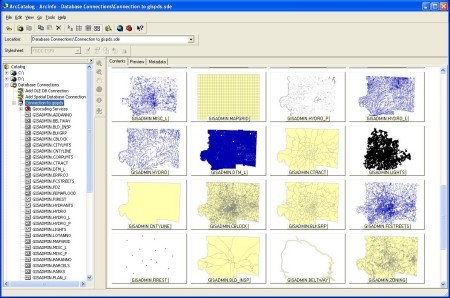
An ArcSDE v8.1 / Oracle v8.1.6.3 enterprise repository was implemented onto a Sun (Solaris 8) Unix platform for long-term GIS intensive activities. In order to comfortably support internal and external (web) processing and queries, high availability and performance were top priorities in developing such a system. High data availability was an operational requirement; especially where ArcIMS applications were concerned. This data warehouse solution transitioned much of the processing to support user queries from the clients’ desktops to the ArcIMS and ArcSDE GIS servers. The server processing improved distributed I/O performance, reduced network traffic, and significantly reduced interface response times. The establishment of this centralized GIS data warehouse was pertinent in reducing enterprise support and maintenance issues for the majority of desktop clients. The weekly importation of specific “master” spatial data sets to the ArcSDE data warehouse facilitated the update operational requirements. Moreover, the system is expandable to account for additional data sets.
Web based solutions provide a low cost and efficient way to access spatial information to users. At the present time, traditional “hard-core” GIS users will continue to require the high end processing and analyses of ArcGIS (ArcInfo) and ArcView (v3.2a) application environments. The majority of clients require simple query, analysis, and map product solutions to support business decisions within departments. An Internet/Intranet map service (IMS) solution is a very efficient way to create dynamic GIS services instantaneously available to the enterprise at minimum cost.
GIS web technology within the City did not have a presence. With departments wanting to access and disseminate information easily within the city and the public wanting to access information from the city, GIS web technology had to be implemented to facilitate these needs. By hosting GIS services in an open capacity, city and public users will not only be able to access GIS related data sets, but will be able to conduct analyses “on the fly” for better decision support and, in turn, expand their GIS knowledge base.
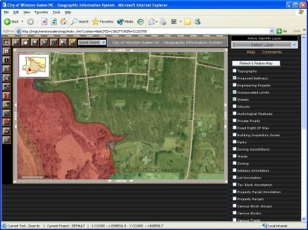
The web services had to be dynamic and interactive. The ability to access data and information from local desktops’ web browsers (Internet Explorer v6.0.2), as well as to create and distribute data to other departments and users is essential for the enterprise to work effectively. A core enterprise wide web application solution was developed utilizing ColdFusion v5 and ArcIMS v4 technology to replace the existing stand-alone desktop ArcView application. The goal is to have all city users to have browser access to a web based application (ArcIMS) that continually fulfills business functionality requirements and to sustain high-end desktop software (ArcGIS) for high-end functionality users to the core master data sets. In this regard, the implementation ArcSDE was a pertinent component for the implementation of ArcIMS.
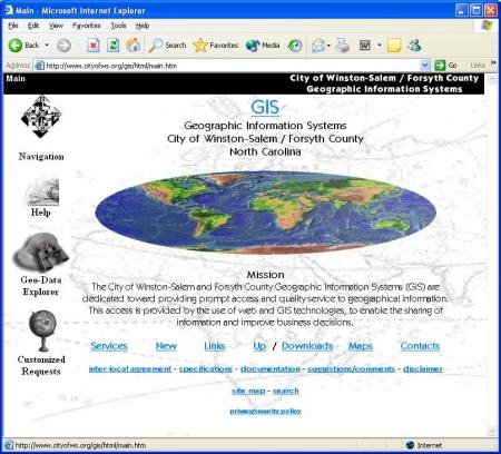
The City initiated and completed the development of a City / County collaborative GIS web site for the open distribution of geographic information and data. GIS web pages are pertinent for internal departments and the public to have a focal location to gain access to GIS related content. As in the case of GIS web services, a GIS web site did not exist, hence limiting the “dynamic” advantages and openness in which the Intra / Internet provides and the strategic I.T. plan advocates.
The GIS web site was developed internally by the City’s Information Systems staff and with the guidance of the City / County GIS TAG (Technical Advisory Group). The GIS TAG consists of City and County GIS technical users who assist in the introduction and leadership of city and county initiatives in respect to GIS related activities. With the direction of the GIS Steering Committee, the GIS TAG collaborated to provide this open GIS portal at: http://www.cityofws.org/gis/html/main.htm
A gradual transition has been initiated for accessing and editing with legacy GIS applications (ArcInfo workstation and ArcView 3.x) on traditional Unix workstations and Windows desktops to the “new generation” ArcGIS ArcInfo v8.x desktop (ArcMap, ArcCatalog, ArcToolbox) and ArcIMS utilizing ArcSDE.
Editing GIS data sets in coverage and shape formats, in the short term, will continue to be conducted on internal departmental Windows workstations. ArcSDE layers will be extracted to a coverage and/or shape file format to the users’ workspace, as applicable. These departmental updated data sets would then be converted and imported into ArcSDE / Oracle via ArcGIS tools (ArcCatalog). Legacy ArcInfo and Arc View applications will be utilized to edit the data sets until a legacy transition plan is implemented.
Primary editing and maintenance processes must be altered in key departments to take advantage of ArcSDE technology and ArcGIS “new generation” functionalities. User software training and support, as well as legacy application redesign must be phased in. NFS mounting must continue to be progressively phased out as web enabled applications take precedence for primary access and functionality.
To take greater advantage and to leverage the “new GIS”, mobile data collection must be infiltrated into the City’s mainstream business practices. ArcPad or similar software will enable users to extend the GIS functionalities from the desktop to the field to encompass the enterprise.
Users will be able to display and edit standard format data sets and upload changes to the GIS enterprise via desktop and/or through GIS web access (ArcIMS). Industry standard vector and raster data (images) can be viewed by the way of user defined forms. Field data collection via GPS and wireless technologies must be scoped and implemented within this solution(s).
GIS and web technology enable openness by integrating different databases and interfacing with several other technologies across the enterprise. This openness provides a spatial awareness to the increasing user base. In addition, knowledge of GIS technology and functionality are increased due to the web focal point of spatial solutions and information.
The objectives are to decrease costs to users by reducing local desktop software and license purchases, provide easier and increased accessibility to a shared standardized data repository, provide a sound and scalable infrastructure, and to provide responsive technical / maintenance support and successful training to the business solution(s) deployed.
With these objectives in the forefront and enabling technologies such as GIS and web, it is pertinent to be aware of new technology that may provide solutions for the business requirements. For these solutions to be successful management backing, user support and involvement, and a sound implementation team are pertinent.
Lan Holtsclaw, Brian Shoaf, Montu Shah, Gary Koontz,
ROK Technologies, Inc.
With knowledgeable resources, the vision is being successfully implemented.