The increasing importance of GIS data in water resources engineering requires today's engineers to have access to and be able to process this data in analysis and computer modeling. Through the use of Esri's ArcObjects technology, GIS tools and data sets are being integrated into the Watershed Modeling System (WMS) developed by the Environmental Modeling Research Laboratory at BYU. Using ArcObjects with this software, engineers will be able to exchange GIS maps and their associated databases in any format supported by ArcView 8.x in the analysis of watersheds and surface water and groundwater models.
The importance of using GIS data in today's water resources modeling is great. As data becomes available electronically, more and more computer modeling is being done in place of traditional paper based approaches.
In the field of water resources, the use of digital terrain data has become even more important for creating computer models. The Environmental Modeling Research Laboratory, at Brigham Young University, Provo, Utah, is involved in creating software in the field of water resources. Three programs are being developed the Groundwater Modeling System (GMS), Surface Water Modeling System (SMS), and Watershed Modeling System (WMS). Each of these programs can take advantage of the various GIS data sources for creating or characterizing models. GMS can use GIS data sources such as soil permeability layers for setting up groundwater models, while SMS can use streambed roughness layers for setting up two-dimensional surface water models. WMS can use GIS data layers for computing hydrologic model parameters.
At the present, there are two methods currently used in the field of water resources to link GIS data with various models. Both have their own strengths and weaknesses. The first is to use scripts and macros within the GIS, while the second is to export GIS data to another program.
In using a GIS to develop water resources models, a user can take advantage of the built in GIS functions for maintaining and processing data. The fact that the data is stored in a database makes it easy to manage and access. However, in order to create a water resource model, this data has to be processed through scripts and macros, which may or may not be readily available. In addition, it is difficult to develop topologically correct water resource models and edit both the spatial and tabular data in a GIS.
Specialized programs separate from a GIS can have better tools specifically designed for editing data, but these specialized programs lose the strengths of managing data in a GIS. These programs can have good interfaces to input parameters for specific water resources computer models. However, some GIS spatial or tabular data can be lost or ignored when exporting it from the GIS and reading it in to another program.
ArcObjects is based upon Microsoft's Component Object Module (COM) technology. This technology allows developers to expand ArcGIS platforms and develop customized applications. DLL's allow access to core GIS capabilities. With this new technology, it is possible to use GIS' data management capabilities in other specialized programs. This allows the developer to combine the strengths of GIS and the strengths of specialized programs in a single package.
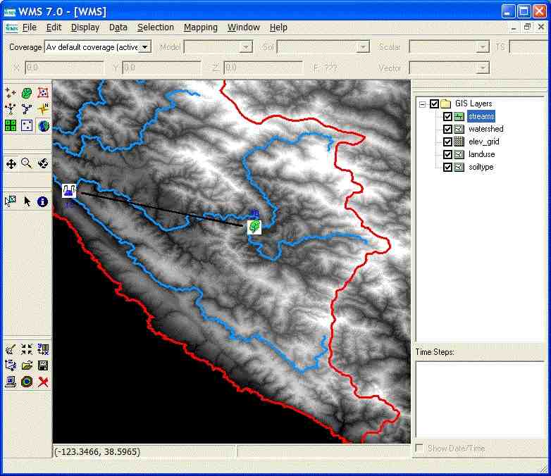
Various GIS data sources are of great importance to water resources modeling. Feature (vector-based) data is used to represent things such as streams, watershed boundaries and material (soil, land use, permeability, or another type) zones. Raster data such as digital elevation models is used in characterizing the layout of elevation or other attributes in a model. Images such as aerial photos can help in performing drainage analysis or determining soil properties. TIN-based surface data can be used to calculate the flow of water. Programs taking advantage of ArcObjects can be used to directly load and display these GIS maps and databases when performing their analysis.
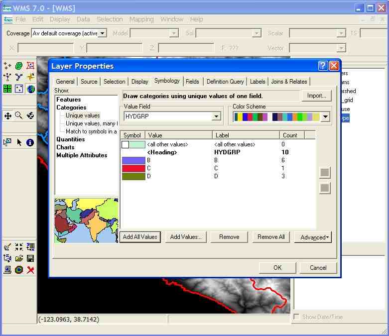
Once data has been brought into a water resources model, that data must be understandable to the engineer and others who view it. This requires the ability to change its display properties. Engineers can take advantage of the advanced display capabilities of ArcObjects by editing the symbology properties of a GIS layer. Data can be displayed in other programs using ArcObjects routines.
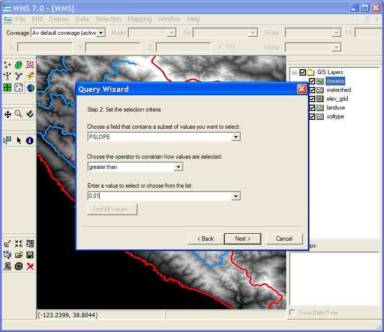
Another advantage of using GIS capability in a customized program is being able to use database queries on attribute tables. These functions can be quickly used to find areas of a model that meet certain criteria, such as locating fish habitats based on channel velocity, sediment and nutrient data.
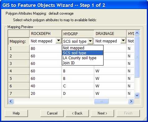
Customizations in GMS, SMS, and WMS allow the user to extract data from GIS data sources and convert it into feature objects (a vector-based format these programs understand). Without using ArcObjects, these programs were limited in their capabilities to import shapefile data. In addition, they were forced to convert an entire shapefile to feature objects, which could take some time depending on the file size, or load up the shapefiles into ArcView and clip out the desired area using the GeoProcessing Wizard. Using ArcObjects, the process involves loading the GIS data, selecting the desired features to convert, and then converting their database attributes to feature object attributes.
Traditional methods of water resources computer modeling have both advantages and disadvantages. GIS software can better manage the data. But GIS software requires scripts and macros to perform water resource analysis and is more difficult to edit. Other programs can be more useful for setting up water resource models, but lack the power and functionality of a GIS in storing maps and databases. ArcObjects allows engineers to use GIS functionality in setting up water resources models in specialized software, combining the strengths of GIS software and specialized software.
Environmental Modeling Research Laboratory (EMRL). (1998). Watershed modeling system (WMS) reference manual and tutorial, BYU, Provo, Utah.
Environmental Systems Research Institute, Inc. (Esri). (2001). Exploring ArcObjects Vol. 1 - Applications and Cartography, Redlands, Calif.
Douglas J. Gallup
Research Associate
Department of Civil and Environmental Engineering
Brigham Young University
Provo, UT 84602
Phone: 801.422.5713
E-mail: gallup@byu.edu
E. James Nelson
Assistant Professor
Department of Civil and Environmental Engineering
Brigham Young University
Provo, UT 84604
Phone: 801.422.7632
E-mail: jimn@byu.edu