ABSTRACT
This paper presents the implementation of an enterprise GIS through a web based application at the Otay Water District (OWD), the second largest district in San Diego County. For decades, engineering staff have located parcel maps, as-built drawings, and records of survey maps by physically going to the record room and manually searching for the records. This tedious and cumbersome procedure was inefficient and error-prone and thus, hindered the productivity of the water district. The newly developed enterprise GIS provides district-wide GIS services through a well-designed ArcIMS application for the Intranet and desktop application for field staff, based on GPS collected, high-precision facilities data. The web-based application is connected to the DBMS to access not only engineering drawings, but also the enterprise tabular database. The new system would improve the efficiency and accuracy of the data retrieval, mapping and analysis .
Otay Water District is a publicly owned water and sewer service agency, more specifically, a California Special District. The District is located in south San Diego County and encompasses approximately 129 square miles with a parcel base of approximately 50,000 parcels. OWD facilities serves the water and/or sewer service needs to a population of approximately 142,000 living in the surrounding communities. OWD is the fastest growing district in San Diego County, adding approximately 50,000 customers since 1999 and almost 4,000 new accounts in 2001. The District is responsible for the design, construction, operation, maintenance and update of potable water, reclaimed water and wastewater facilities within its boundaries.
GIS has been regarded and proven as an efficient and powerful tool in the water distribution industry. According to American Water Works Association, 90% of water agencies are now partially using GIS to assist their daily operation. The business operations in the water/wastewater industry requires the District to keep complete and detailed inventory, including location and condition of all assets such as water mains, valves, hydrants, meters, storage facilities, sewer mains, and manholes. GIS is a state-of-the-art technology capable of efficiently performing all these data- related processes. In addition, GIS can be used for applications such as:
OWD is currently maintaining 400 miles of water mains, 13.42 miles of reclaimed mains, 22.28 miles of swer mains and 38 operational storage reservoirs and related facilities, such as, fire hydrants, valves and water taps. OWD also supports customer calls associated with water breaks and water pressure problems and provides all services regarding water meters.
The business needs of using geographic location data were requested by :
(see Figure 1 below)
Figure 1
The geographic information is used everyday by the District staff and other service providers within the District by criteria, such as street address, parcel ID, owner, facility page number or etc. The utilization and management of spatial data supports not only daily operations within the District, but also decision support functions, such as, system planning, decision making and boundary issues. The GIS system is a jointly funded and managed District asset that provides the institutional setting and data exchange mechanism so that each department can minimize its own individual expense and maximize its contribution to the District.
When OWD began the process of implementing GIS in 1995, PlanGraphics (a consultant company) was hired to formulate an implementation plan to ensure that all of the operational and technical issues were identified and addressed in a practical, structured and prioritized manner. The delivered document, a report entitled "Otay Water District GIS Conceptual Design and Implementation Plan" defined and proposed the scope of the GIS system, the schedule for implementation and the budget. This required document served as a guideline for the District's GIS data structure and data collection, as well as a conceptual guide for application development.
As recommended in the implementation plan, an engineering services firm was hired to collect cadastral base map and facility base map data within the District in order to establish a shared database used by all OWD departments and staff. The data has been submitted and stored at the District's central data server. Based on the implementation plan, a GIS system infrastructure, which includes hardware, software and staffing, was defined and implemented.
To accurately determine and define the GIS needs of various departments within the District, a district-wide GIS User Group Committee was formed to conduct management review, prioritize projects, discuss GIS related functions and issues, set-up short-term and long-term project plans and report the projects status. The committee is tasked overseeing the implementation of GIS within OWD.
While collecting GIS over several years, the District saw the need to integrate and access variety of information and applications, with a geographic components into one manageable system. GIS demonstrated the advantage of organizing, managing, and distributing geographic information culled from various databases while maintaining data integrity and focusing on project direction. The District also recognized the power of web-based GIS to present data in real-time and provide access to staff district-wide at an overall lower cost than utilizing desktop applications like ArcView low. The MapObject based application was migrated to ArcIMS application as it was considered more efficient in terms of customization and data exchange. It is also more compatible with Geodatabase with ArcSDE which is under the District's current implementation plan. As end users are provided with the new technology, new requirements are developed and the implementation plan is revised to accommodate the new requirements.
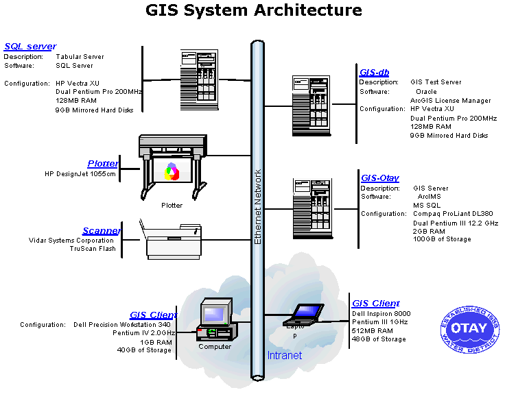
Otay's GIS system is now fully integrated into the District's LAN system. The District has two GIS servers and an enterprise data server. The new GIS server, GIS-Otay, also serves as a host server of ArcIMS, ArcGIS and MS SQL Server. Another server, GIS-db, serves as a testing server with ArcGIS license manager installed. The District switched database platform from Oracle to SQL server due to the efficiency in terms of organization size and administrative resource. Other GIS peripheral devices include scanners, printers and 36 inch plotter. The GIS system architecture is shown figure2.
Figure 2
The web-based GIS applications are client server applications accessible with a browser over the Intranet and Internet. Server programs, residing and running on the server machine, handle all the request submitted by users though a client interface, either through an HTML form or a program running under a web browser. The server side usually consists of many technologies working together, such as, databases and middleware. Middleware has the function of dividing information into small packets and checking their receipt by the client. The server program handles all the data access and GIS spatial manipulations. The client programs interact with users and communicate with server programs through the interfaces.
Esri's ArcIMS 3.1 was selected as OWD's web GIS solution. Recognizing the need to accommodate future growth in applications, the District chose this solution due to its highly scaleable server architecture for supported clients and its server potential. Since the ArcIMS server technology is part of a multitier architecture, the ArcIMS framework consists of clients, services, and data management. Serverside components is composed by ArcIMS Spatial Server, ArcIMS application server, ArcIMS application server connectors and ArcIMS manager. Among the two clientside viewers, ArcIMS Java viewer and ArcIMS HTML viewer, HTML viewer was selected for our client interface to avoid extra java plug-in downloads which might confuse non-computer orientated staff.
OWD's ArcIMS web site has been configured to combine ArcIMS spatial servers, ArcIMS application server and web server into one high end GIS server based on the volume of anticipated users between 100 - 1000 maps per day. Servlet engine was chosen as the application connector that runs in conjunction with a web server to enable Servlets to run on the server.
The enterprise database consists of both spatial data and tabular attribute data. GIS layers which depict the District's highly complex water distribution system were created using existing paper maps, engineering design documents and as-built plans as the primary sources. Geographic components were GPS data and were converted to features within the GIS system before attributes were individually assigned. Utility data, cadastral data and the high-resolution digital orthophotos are the major GIS data collected based on the data categories needed within the District. The database is significant in size and content, and has become a major asset of the District.
The core attributes are data elements linked to map features that are used to support routine mapping, queries and geographic analysis. These attributes' information are stored and managed inside the shapefile as shown in Table-1 below.
| GIS Database Structures |
|
Data Group |
Data Layer |
Subtype |
Core Attributes |
| Water Facility Lines | Transmission lines | Pipe length, pipe size, pipe material, pipe class, as-built drawing, encasement status, status(prop.,exist.,aband.),owner | |
| Potable water mains | |||
| Service lines | |||
| Water Facility Points | Connection points | eature type code(AV,BO,FH,etc.), name, survey status, owner | |
| Reservoirs | |||
| Pump stations | |||
| Fire hydrants | |||
| Fire services | |||
| Meters | |||
| Valves | |||
| Valves Other appurtenances |
Air-vacs, Blow-offs, End caps, Chlorine stations, Cathodic test stations, Pressure reduction stations, Reducers,Backflow prevention devices, Water test stations | Feature type code(AV,BO,FH,etc.), name, survey status, owner | |
| Recycled Water Facility Lines | Recycled water mains | Pipe length, pipe size, pipe material, pipe class, as-built drawing, encasement status, status (prop.,exist.,aband.),owner | |
|
Service lines
|
|||
| Recycled Water Facility Points | Meters | Feature type code(AV,BO,etc.), name, survey status, owner | |
| Valves | |||
| Other appurtenances | Air-vacs, Blow-offs, End caps, Cathodic test stations, Reducers | Feature type code(AV,BO,etc.), name, survey status, owner | |
| Wastewater Facilities Lines | Sewer gravity mains | Pipe length, pipe size, pipe material, As-built drawing, encasement status, status (prop.,exist.,aband.), owner | |
| Sewer force mains | |||
| Sewer laterals | |||
| Wasterwater Facility Points | Treatment plant | Name, survey status, owner | |
| Other appurtenances | Cleanouts, Manholes, Overflows, Plugs, Sewer lift stations, Sewer reducers, Sewer tanks | Feature type code(MH,CO,PG,etc.), name, survey status, owner | |
| Survey Control Reference Grid | Primary control network | Point number, elevation, and description | |
| Secondary control network | |||
| Digital orthophotos | Elevation | ||
| Cadastral Base Map features | Parcel | APN, Site address, Owner Name,etc. | |
| Centerlines | Address ranges | ||
| Political/Administrative Boundaries | OWD Boundary | ||
| Municipal Boundaries | |||
| Director Division Boundaries |
Table 1
As OWD is the fastest growing district in San Diego County, the timely maintenance and update of GIS data is and will be a challenge. New data models and procedures for further data maintenance are currently under development and require participation and cooperation from each department.
High-end laptops were given to the field crew as their mobile solution to access GIS data. An ArcView application called "e-facility" was installed on fifteen Dell laptops configured with 1 GHz PIII PROCESSOR, 15"UXGA, 512 MB SDRAM. Field personnel utilize "e-facility" for map creation, facility locations, asset maintenance and replacement. The data on the laptop will be synchronized with the central data server on a quarterly bases. The "e-facility" basically incorporates the major ArcView functions with customized functions for data browsing.
With the District's centralized data warehouse and network users, the District shows its strong requirements for accessing GIS data through a LAN system which the web-based GIS solution was the right fit. Distributing geographic information over the web allows real time data integration in a cost-effective manner. Web based GIS opens many new opportunities, such as, geographically communicating with one another in presenting ideas and integrating information or decision making. Furthermore, the interactive maps allow users to query the data to derive more information.
To create consistent user interface with laptop access utilized by the field staff and desktop applications for ArcView users, a customized ArcIMS application was developed with a user-friendly interface and a GUI similar to ArcView. (See Picture 1 below)
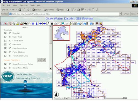
Picture 1
Besides the basic ArcIMS functions provided by the application itself, the application integrates and adds more functions designed specifically for the District's needs. Since the GIS database is composed of both the geographic data and tabular data, the ODBC connection, along with ASP technology, were adopted in developing and querying the relational database. The new tools/functions that were added follows:
Based on the structured GIS data, the District's utilities are grouped into major facilities including reservoirs, transmission lines, pump station, meters, etc; the potable system including water mains, water laterals, fire hydrants, fire services, water appurtenances, appurtenance lines, etc.; sewer system including sewer mains, sewer laterals and reclaimed system including recycled mains, recycled appurtenance lines, recycled points, recycled meters. The grouped data is presented on the website utilizing the water industry standard color code. To make the website more efficient for the end user who wishes to focus on an individual system, like the reclaimed water system, the system's interface supplies a grouping function that can turn the above system "on" or "off" as a group with one click as opposed to requiring the user to turn each layer "on" or "off" one at a time.
In the finance department and engineering public services, account availability (AV) data, which supplies the parcel based tabular information, is used for customer service. It is extremely critical to be able to access both the tabular information and the geographic data at the same time. An individual DBMS, created for AV data, was linked into the district's GIS system through SQL query using ASP. The web interface integrates the searching function into a major GIS web page that, besides allowing the searching function, users would still have the privilege to apply other GIS functions within the same window. (See Picture 2 below)
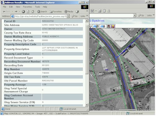
Picture 2
Search by parcel number (APN)
By providing the APN number on the web interface, users are able to zoom into a particular parcel area, while also obtaining the corresponding AV data information such as owner, address, tax rate, flood zone and etc. Engineering front counter personnel utilize this function to find and print location maps with AV information for internal reports or for the external developers. Furthermore, users can also display the orthophotos with one feet resolution beneath the parcel lines.
Search by owner
By providing the owner’s “full name” or “last name”, the search engine will provide the candidate list for the user to make a selection. After the user verifies the individual he is searching for by clicking on the individual’s name, the web browser will provide the same parcel information mentioned above.
Search by property's site address
By providing the site address, the search results will present the matched parcel information and display both tabular and graphic format.
Traditionally, all engineering drawings have been stored in a record room, requiring a large amount of storage space. If the design engineers or the field operators wish to see the as-built drawings, they must physically pull the mylar in the record room and copy the drawing before they can take it to where it is needed. This procedure is time consuming and cumbersome.
The benefits of digital recordings and storage for engineering drawings is the ability to electronically store and archive the utility's entire record drawing inventory and provide direct access to the drawings. The access via the web browser, specially, through graphic features (which represent the physical entities) provides user a visual solution for utility maps exploring. The District’s engineering drawings have been scanned and recorded in digital format and have been fully integrated into the GIS database. Each line and point feature was attributed with a unique ID linked to the as-built drawing ID’s. Engineering and operations staff use the web-based GIS to access a particular facility by clicking on it. This function supplies an easy, fast access to the as-built inventory for engineering staff to verify system availability, planning, inspection assistance, etc. Other staff members also utilize this function for browsing as-built drawings for internal projects. (See Picture 3 below)
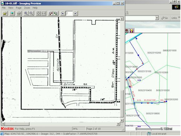
Picture 3
Otay Water District has fully replaced manual paper map searches with the interactive GIS map allowing staff to retrieve engineering drawings, record drawings, survey maps, etc.
The Geocode function with road centerline data provided by Geographic Data Technology, INC (GDT) was adopted as a supplemental search option for locating utility pipelines and point features. For instance, in the finance department, customer service representatives usually receive phone calls from customers who do not know whether they are within Otay’s service area. By typing in the address provided by the customer, the customer service representative can quickly locate the customer’s service area by identifying the water district layer to supply the customer with the other agency’s service number. This address matching function also helps the operations staff locate facility assets and as-built drawings quickly in real-time when an emergency has been reported.
Printing facilities, cadastral or other graphic features for reports, presentation and file from web GIS is a handy tool for the District’s daily business. Additionally, the requirement for different size printouts demands more mature printing options. The customized printing function provides users the ability to chose different size and layout option for printing. .
Demographic and land use analyses give the utility group more effective means for planning new construction and maintaining existing infrastructure, as well as provide for a means of anticipating future growth. The enterprise GIS database has been used for water demand analysis, planning and projection analysis. Supplanting paper mapmaking methods, GIS was also used to redistrict the District’s director divisions in 2002 as required by law. The ability of accessing the central GIS data and demographic information made the GIS system the most efficient solution for the redistricting. The result was also posted through Intranet for interactive mapping.
The GIS system, based on locational information, proved to be a center piece in integrating data and application in a water utility which generally has large amounts of data from a variety of categories. The GIS application, especially the web-based application provides great accessibility and can be implemented with user-friendly interfaces. It can be an efficient and productive tool for staff in different departments within a water utility.
GIS data collection and database creation is a costly and time-consuming process. However, it is certainly worthwhile when the data can be appropriately used to improve the organization’s daily operation. At Otay Water District, the web-based GIS application provides the non-professional GIS user with easy and fast access to the centralized GIS data to assist them in their day-to-day work. The web-based GIS application also serves as an educational tool for district staff to explore how GIS technology can further improve their daily business procedure/practices. The District staff is discovering a wide variety of uses for GIS along with other related tools, such as, H2ONET, H2OMAP, SCADA ,etc. The web-enabled GIS also allows a wide range of potential improvement and enhancement alternatives, providing the water utility team the ability to readily optimize programs such as CIP. It also makes it easy for a utility agency to work seamlessly across platforms and to manage water systems in an enterprise environment. The web-based ArcIMS application demonstrates the real power of an integrated system that can eventually be linked to the other tabular enterprise systems, such as, billing system, work order management, SCADA, CIS and permitting system.
By adopting Esri’s off-the-shelf ArcIMS 3.1 and customizing its interface/functions with the District’s requirements has saved valuable time and has also made the implementation of the enterprise GIS system efficient. Further developments are expected to meet the needs of the District. The monthly GIS User Group meetings have proven to be valuable for gathering user inputs for further customization. The District also sees the need for the geometric network to reorganize centralized data. The Geodatabase design and implementation project is under development to improve the intelligence of the data structure and web base GIS.
The authors would like to acknowledge and thank the following professionals, Bill Jenkins, Susan Cruz, Ron Banuelos, Cora Stephenson and Amy Weiland for their precious inputs and participation.