The National Pollutant Discharge Elimination System (NPDES) is a federal program to regulate discharge of pollutants into United States waters. A spatial database, to support local governments in their effort to meet NPDES guidelines for maintenance and operation of their storm drain systems, is described. To viably meet horizontal accuracy specifications, GPS ground survey methods, 1”=100’ scale planimetric drainage mapping, and topographic data at 1-foot contour interval are illustrated. Street centerlines, parcels, and storm drain rights-of-way provide a cadastral background to the system. A relational database design is implemented to manage the system and support NPDES reporting standards.
The National Pollutant Discharge Elimination System (NPDES) permit program evolved from the 1972 Clean Water Act (CWA) to regulate the discharge of pollutants to United States waters. Initially, attention was focused on sources such as sewage treatment plants, industrial facilities, and toxic pollutants (DDT, PCB, TBT). Since 1987, the focus has shifted to pollution from land runoff, a source relatively ignored until amendments were made in 1987 to the CWA to establish a framework for regulating urban storm water runoff. The Santa Ana Regional Water Quality Control Board (Regional Board) started regulating municipal storm water runoff in the region since 1990 as a consequence of the 1987 amendments.
Studies have shown that urban storm water runoff is a major source and leading contributor to impairment of water bodies. The Environmental Protection Agency recognizes urban runoff as the prime source of estuarine pollution in coastal communities (US EPA 1999). A definite link has been established between urban storm water runoff and pollution in near shore zones (Bay 1999 and Haile 1996). Several Orange County beaches were closed in 1999-2000 due to detection of microbial contamination. San Bernardino areas ultimately drain into the Pacific Ocean, impacting Orange County beaches.
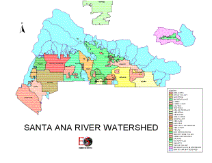
The San Bernardino County Flood Control District, as the principal permittee, together with the County of San Bernardino (County), and the cities of Big Bear Lake, Chino, Chino Hills, Colton, Fontana, Grand Terrace, Highland, Loma Linda, Montclair, Ontario, Rancho Cucamonga, Redlands, Rialto, San Bernardino, Upland, and Yucaipa, as co-permittees are permitted by the Regional Board for the control of pollutants in urban storm water runoff within their jurisdictions. A population of approximately 1.33 million, over an area of slightly under 1,000 square miles, is served by these permittees. Recent estimates detail 384 miles of above ground channel and 334 miles of below ground storm drain in the area. Approximately 7% of San Bernardino County drains into water bodies within the jurisdiction. Discharge from the Upper Santa Ana River Basin Watershed drains into the Santa Ana River.
Urban runoff over industrial, commercial, residential, and municipal areas convey pollutants collected from these areas and transport them to U.S. waters through the storm water conveyance system. Runoff contains (Pew 2001):
Pathogens (Bacteria, viruses, protozoa);
Biostimulants (Decaying/decomposing organic wastes, plant nutrients);
Pesticides (DDT, chlordane, diazinon, chlorpyrifos);
Toxins and Heavy Metals (Biocides, PCBs, cadmium, copper, chromium, lead, zinc);
Petroleum Products (Oil, grease, petroleum hydrocarbons); and
Sediments.
Urbanization changes stream hydrology and results in pollutant loading to receiving waters. Several impacts on watersheds experiencing urbanization are:
Increased Impervious Surface Area,
Increased Runoff Volume,
Increased Runoff Velocity,
Decreased Riparian and Wetland Habitats,
Increased Frequency and Severity of Flooding,
Increased Pollutant Loading,
Increased Toxicity to Marine Organisms,
Decreased Aquatic Resources, and
Detrimental Impact on Human Health and the Environment.
Figure 1: The Santa Ana River Watershed and Co-Permittee Jurisdictions
It is essential that regulation and control of water discharges in watershed management of the upper Santa Ana River Basin be tackled in an area-wide approach. The storm drain system is managed by the several entities listed above and the State Department of Transportation (Caltrans). Several other significant contributors to runoff include the state university system, schools, hospitals, federal facilities (including military installations), state agencies, water and wastewater management agencies, the National Forest Service, and state parks. Cooperation of all these entities is a prerequisite to affective management and control of the entire flood control system. The Regional Board chose the best management option of a single area-wide storm water permit for the entire region in an integrated watershed management approach.
The City of Big Bear Lake pioneered the implementation of an automated spatial management system for the administration of storm water infrastructure within its jurisdiction. The development was implemented in close collaboration with the County NPDES Team to serve as a prototype for other jurisdictions to follow.
The Santa Ana River Watershed has been subdivided into the following sub-watersheds:
Upper Santa Ana River Watershed,
Chino Basin Watershed, and
Big Bear Lake Watershed.
The Big Bear Lake watershed is located in the San Bernardino Mountains. Big Bear Lake, identified as one of the several receiving waters in the Santa Ana River watershed, is a high mountain reservoir supporting recreational activities, including fishing, swimming, boating, and water skiing. Adjacent areas are used for camping, skiing, hiking, equestrian trails, and other outdoor activities. Lake water is utilized for municipal supplies. Problem pollutants associated with the water bodies have been identified as coming from resource extraction activities, urban runoff, snow skiing activities, construction and land developments, and non-point sources.
Total Maximum Daily Load (TMDL) is the total amount of each problem pollutant that can be discharged, maintaining water quality standards in the receiving water, so that water quality objectives are met and beneficial uses protected. TMDLs for these pollutants are being developed in conjunction with local stakeholders and are expected to be finalized by 2004/2005. The watershed includes the following major water bodies, several of which have been designated as impaired in the 1998 303(d) list (pollutants are specified within parentheses). Impairment refers to water bodies where the designated beneficial uses are not met and the water quality objectives are being violated.
Big Bear Lake (nutrients, copper, mercury, metals, noxious aquatic plants, and sedimentation/siltation),
Knickerbocker Creek (metals and pathogens),
Rathbone Creek (nutrients and sedimentation/siltation),
Summit Creek (nutrients),
Grout Creek (metals and nutrients),
Baldwin Lake,
Stanfield Marsh, and
Shay Meadows.
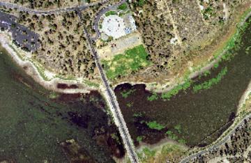
Figure 2: An example of a digital ortho-photograph tile of the City of Big Bear Lake
The following requirements are outlined as storm water regulations of the NPDES permitting process:
Prohibition of non-storm water discharges to the storm water systems, with certain exceptions.
Development and implementation of a drainage area management plan (DAMP) by municipalities to reduce pollutants in urban storm water runoff to the maximum extent practicable (MEP).
Discharges from the storm water systems must meet water quality standards of receiving waters.
Identification and elimination by municipalities of illicit connections and illegal discharges to the storm water systems.
The establishment of legal authority to enforce storm water regulations by municipalities.
Monitoring of dry weather flows, storm flows, receiving water quality, and required program assessment.
Implementing a strategic and comprehensive public and business education outreach program targeting businesses, industry, development, utilities, environmental groups, institutions, homeowners, school children, and the general public.
Education and training of municipal planning, inspection, and maintenance staff to address public agency facilities and activities including sewage systems, maintenance and material storage areas, landscaping, storm drain systems, and streets.
Restoring and preserving natural hydrologic cycles in the urban development approval process. Best Management Practices (BMP) are to be exercised in management of new developments or significant redevelopment projects.
Determination of the impact of exfiltration from leaking sanitary sewer lines, leaks and sewage spills from blocked sewer lines, improper use of portable toilets and failing septic systems, and the impact on the storm water system. All sanitary sewer lines greater than or equal to 24" are to be inspected and tested at least once during the permit cycle.
For each of the 16 municipalities in San Bernardino County participating in the program, implementation of NPDES program requires the development of a Storm Water Management Plan.
The City of Big Bear Lake was the first jurisdiction to start on the development of an automated interface for the storm water facilities information management. The system has been designed to inventory storm water infrastructure within its jurisdiction, maintain information related to inspection and maintenance operations of physical assets, support code enforcement of regulations and issuing citations, and report on activities pertinent to the permit process.
The project was implemented in collaboration with the County, to meet an overall specification that is being developed to conform to the requirements of the NPDES program.
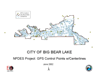
Figure 3: GPS Survey of Ground Control Points and COGO of Street Centerlines
The City of Big Bear Lake (City) has recently implemented a storm water management project on the basis of recommendations of a hydrology study conducted throughout its jurisdiction. In 2001, the City initiated the development of an inventory of the City's storm water infrastructure to support the creation of an automated system to manage the facilities. The facilities have been entered into a Geographic Information System (GIS) to facilitate future management of the storm water system for engineering operations, inspection, maintenance, code enforcement, and NPDES reporting for the required permitting process.
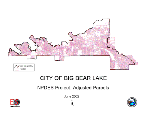
Figure 4: The City of Big Bear Lake Parcel Base Map After Rectification of Parcels for Registration to COGO-ed Street Centerlines and their Offset Rights-Of-Way
To attain a project horizontal accuracy of +2 feet, a combination of GPS survey control, photogrammetry, and coordinate geometry (COGO) was utilized to input data to map storm water facilities and cadastre. Survey was coordinated with the San Bernardino County Surveyor to ensure best-fit practices were observed between the photogrammetric survey and the County Cadastre.
Street centerlines were COGO-ed, utilizing parcel and tract maps at the GIMS data center. Property data previously digitized by the City was then rectified to match right-of-way boundaries generated from the centerlines.
As a follow-up phase, the City has ordered digital ortho-photographs based on an accurate digital terrain model designed for 2' contours for a vertical accuracy of +1 foot. The GIS database was designed to complement the NPDES Database Reporting Module.
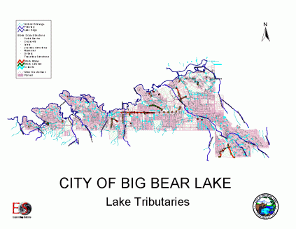
Figure 5: A Complete Inventory of Storm Water Infrastructure within the City of Big Bear Lake
Infrastructure was classified under the following categories:
Big Bear Lake Perimeter
Major & Minor Streams
Natural Drainage
Stormwater Structures
| Open Channels | Underground | Inlets | Basins |
|---|---|---|---|
| Channel | Box | Culvert | Debris Basin |
| Curb & Gutter | Pipe | Curb Inlet | Detention Basin |
| Designed Street | Manhole | Retention Pond | |
| V-Gutter | Catch Basin |
Two definitions of the lake perimeter were the limits of the parcel base boundary and the data capture of the edge of water surface as stereo-compiled from the aerial photographs. Major and minor streams and natural drainage were also captured by photogrammetry, as were storm water structures that were visible on the aerial photographs.
All underground facilities were digitized per engineering drafting standards from existing as-built drawings provided by the City. The data was registered to visible surface features obtained by photogrammetry. A final field verification of structures throughout the area was conducted to validate the system.
Attribution of all facilities was entered using as-built drawings as the primary source. Up- and down-stream elevations were extracted from the 3-D photogrammetric data for population within the GIS. Each culvert was specifically identified and labeled per City definitions and attribution linked to the City's culvert database.
The database was designed to link up to a preliminary definition of the County of San Bernardino NPDES reporting database. This will allow automated computation of facility lengths and aggregated values for cleaning and inspection required by the reporting process. Each facility will be linked to inspection and maintenance tables for monitoring during the reporting year. New connections investigated and resolved will be incrementally added on discovery for enforcement and permitting according to regulation. Enforcement data on surveillance and reporting of illegal discharges will also be linked to associated inlets.
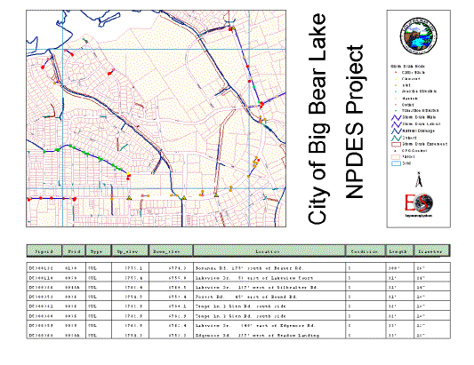
Figure 6: A display of the link to the culvert database
Properties on which businesses are located may be identified as potential sources of storm water pollution and attributed by Standard Industrial Classification (SIC) code. This will allow the future aggregation of industrial facilities during the report generation process.
Business outreach programs and their associated target businesses will also be identified within the cadastral layer. Retailers participating in the Point-of-Purchase Program can be located on the cadastre and impact of the program monitored. Businesses receiving awards, as well as chronic violators, can be spatially identified.
Development and redevelopment projects for which Notices of Intent (NOI) have been filed will be physically located within the GIS environment, as can new permanent flood control measures, which can be graphically portrayed. Periodic maintenance information can be linked to its associated graphic facility.
Photogrammetric data of impervious surfaces, including paved roads, buildings, patios, driveways, sidewalks, etc., allows computation and analysis of impervious surfaces contributing to runoff.
Inlets cleaned during the year can be attributed with the number of times it was cleaned and the total volume of debris removed. Similar attribution can be maintained for segments of open channels and underground drains to enable automated computation of linear dimensions and total debris volume. Similar attribution can also be maintained for detention basins.
Street sweeping data can be recorded against each street centerline segment to compute linear dimensions for reporting purposes. For example, lengths associated with residential, industrial, and commercial areas, frequency of sweeping and debris collected, can be entered, aggregated and monitored for reporting purposes by each co-permittee.
Violations and citations can also be linked to the associated property. Other properties identified will be those associated with parks and recreation, public facilities, and areas where sewage spills have occurred.
The authors wish to acknowledge Scott Arenella, the City of Big Bear Lake's NPDES Activities Coordinator, and Brent Rolf, GIMS Manager of the County of San Bernardino, for their contributions to this effort.
California Regional Water Quality Control Board, Santa Ana Region, 2001: Waste Discharge Requirements for the San Bernardino County Flood Control District, the County of San Bernardino, and the Incorporated Cities of San Bernardino County within the Santa Ana Region, Storm Water Runoff Management Program, San Bernardino County, Order# 01-16 (NPDES# CAS618036).
US EPA, 1999, 40CFR Parts 9, 122, 123, 124, National Pollutant Discharge Elimination System - Regulations for Revision of the Water Pollution Control Program Addressing Storm Water Discharges; Final Rule, 64FR 68727.
Bay, S., Jones, B.H., and Schiff, K., 1999, Study of the Impact of Storm Water Discharge on Santa Monica Bay, Sea Grant Program, University of Southern California.
Haile, R.W., et. al., 1996, An Epidemiological Study of Possible Averse Health Effects of Swimming in Santa Monica Bay.
Pew Oceans Commission, 2001: Marine Pollution in the United States.