The Army National Guard (ARNG) has implemented ArcIMS at its headquarters in Arlington, Virginia. This paper will focus on the issues when implementing Internet Map Server in a military environment. Emphasis will be placed on the methods of customization for ArcIMS and the importance of and methods for focusing ArcIMS design to meet the needs of user.
The Army National Guard is composed of 55 separate entities that collectively support, train, and manage over 400,000 soldiers and more than 3,000 facilities across the United States and its Territories. These 55 independent entities, 54 State and Territory commands (hereafter called simply "States") and the ARNG Headquarters (ARNG HQ), often work with little coordination on issues such as data collection and dissemination. There was no guidance on what geographic data should be collected, how it should be collected, and in what form. Even within the ARNG HQ divisions were in many cases collecting redundant data at least partly because there was no mechanism in place to share existing information. Existing data was simply not available to support decision-makers in making critical decisions that affect ARNG troops and personnel. Over 1,000 potential users of geographics data exist at the ARNG HQ, with only a handful having any access prior to the implementation of the GIS solution outlined in this paper.
Adding GIS capabilities for ARNG HQ personnel will further the goal of integrating databases between Army National Guard Divisions, and to allow ARNG HQ personnel to access data collected by the States. The importance of integrating databases across divisions is an issue that has been receiving increased attention at ARNG HQ. By having ready access to GIS data and software, ARNGRC personnel will be able to present complex data in easy to understand geographic maps and tables. The increased access to GIS tools will result in greater use of GIS maps and other products at ARNG, and will improve the quality of reports and briefings. The secondary focus is to enable State personnel to access data from across the ARNG. The overall vision for the solution is an integrated web-enabled information system that allows efficient access, management, and analysis of geographic data. To accomplish this goal several pieces were needed, including authorization to use the technologies, agreements to share data, a central data repository, policies to support the data repository, personnel, computer systems, and software. The name we have coined for this collective system is the ARNG Geographic Data Server (GDS).
The GDS is composed of two servers. Both servers are running Microsoft Windows NT 4.0 sp6a, are dual processor Pentium III systems with RAID 5 SCSI drives and have connections to the Storage Area Network (SAN). The WWW server (ArcIMS application server) has 2 GB of RAM and 833 MHz processors. The data server has 4 GB of RAM and 733 MHz processors.
The SAN is a stand-alone system with 1.5 Terrabytes of storage space available for the GDS. Logical drives created on the SAN are mapped on the servers with a maximum capacity of around 384 GB per logical drive. Connections from the servers to the SAN are via optical fiber.
Software and technology solutions were evaluated for ease of use, the potential for easy customization, and compatibility with existing data sources and existing software. Based on these criteria, Microsoft SQL Server with Esri's ArcSDE was selected as the database solution, and Esri's ArcIMS was selected for the web implementation. For users who need map development capabilities in addition to the maps produced for the web-based application, we chose ArcExplorer and ArcView 8.x (ArcGIS 8.x). For the web server we are employing Microsoft IIS 4.0 with ServletExec.
One of the key requirements for the GDS was ease of use. Our target audience is the general users in the ARNG HQ and at the States. Most of these individuals would have never used a GIS application before, and therefore simple, intuitive controls are essential. In addition, a large download to install a Java applet is not a good solution for our personnel, especially if the installation requires administrative privileges, which are not commonly provided to our users. An additional factor in determining to use the ArcIMS HTML/Javascipt interface was that our current GIS personnel could do the customization of the interface without substantial time investment in training.
Implementation of this system was accomplished by on-site GIS personnel at the ARNG HQ. Very little of the work was done with outside contractors. The work included development of the database, upload and management of the data, installation of web server software and ArcIMS, customization of the ArcIMS interface, and creation of mapservices. In order to implement the GDS some training of the existing personnel was required including; SQL, the TriState Services Spatial Data Standards (SDS), ArcIMS customization, and Javascript programming.
In order to ensure proper data development and documentation, and the currentness of data in the repository, several policies have been or are in the process of being enacted. These include a metadata policy, Spatial Data Standards (SDS) policy, and a geographic data submission policy. Collectively these policies allow us to require that data developed by the States and within ARNG HQ are compliant with established GIS data procedures, standards, and formats, and are delivered to ARNG HQ for inclusion in the GDS in a timely manner.
Access to the geographic data housed on the SAN is managed via an access policy established to protect the integrity of the data. General users in the ARNG HQ are granted read-only access. Data owners are granted write permission to their data, and data managers are allowed full control of the database. In addition, State personnel are allowed File Transfer Protocol (FTP) download-only access to the site since they cannot access the data on their local networks.
There were originally concerns with allowing the States to access the GDS because of the potential for a high load on the Reserve Component Automation System (RCAS) network. A study conducted by the Army Information Systems Division determined that the bandwidth requirements for ArcIMS using image mapservices were low enough to alleviate this concern. Another issue was how to allow State personnel to access the GDS. The GDS servers are secured behind a firewall that blocks access on the WWW port (port 80) to systems outside the RCAS network. Many States do not have RCAS network access, so to allow those users access we configured the web server and ArcIMS to use Secure Hyper Text Transfer Protocol (HTTPS). This solution utilizes port 443 which is a secure port that is not blocked by the ARNG firewall, thus enabling most State personnel to access the server.
Approximately eight States have or are working on implementing an IMS system with several others set to begin such development in the near future. Since part of the GDS Implementation includes providing installation level data to ARNG personnel one solution is to link to IMS sites established by the State/Territory offices or installations, instead of mirroring their data and creating redundant maps, linking to their mapservices creates an Enterprise system where the pieces are maintained by the data owners.
In order for the GDS Implementation to be successful, it is critical that the system is linked to existing databases that contain data that ARNG personnel use in their everyday work. Such databases contain information on ARNG facilities, units, personnel, as well as land condition, and training allocations. To accomplish this we are acquiring official consent to connect to these databases with Memorandums of Agreement between the parties involved. Options for database access include manual periodic updates, live SQL query access, and regular transactions to the GDS Spatial Data Engine (SDE).
In concert with the GDS Implementation at ARNG we have established a GIS training program to fulfill the needs of non-GIS personnel. We have course tracks for general users and power users. The training program includes the following classes:
Introduction to GIS at the ARNG HQ - an introduction to basic GIS principles, use of the web-based Geographic Data Server, and an introduction to using ArcExplorer to access the data repository. 1.5 hours.
Intermediate GIS at the ARNG HQ - an in depth look at ArcExplorer with a lab on how to conduct basic GIS analysis with ArcExplorer. 2 hours
Advanced GIS at the ARGN HQ - An introduction to ArcView (ArcGIS 8.x). 2 hours.
Data Development and Documentation - instruction in the proper data production methods and how to create compliant metadata. 3 hours.
ArcGIS I and II - Esri's Instructor led ArcGIS classes. ArcGIS I, 2 days; ArcGIS II, 3 days.
In addition, we have provided ARNG personnel with pre-paid seats in classes on Esri's Virtual Campus.
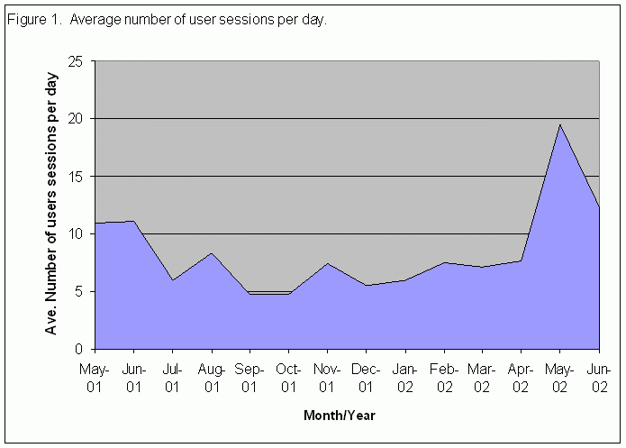
As awareness and training of the GDS has increased so has the usage of the system. The recent increase in use coincides with an increased effort to disseminate information and train ARNG HQ personnel on the use of the GDS (see figure 1).
Because the GDS was an internally developed application, it was relatively inexpensive to implement. For reference purposes, here are the estimated costs associated with this project as of FY02.
Hardware Software Data Storage Labor
The Army National Guard's Emergency Operations Center (EOC) is a critical planning facility where classified and unclassified data is incorporated into the decision-making process for ARNG senior staff. As a result of the aftermath of the terrorist attacks on the United States on 11 Sept 2001, short-comings in the EOC's Emergency Information System have become increasingly apparent. With the implementation of the unclassified Geographic Data Server as a model, work has begun on implementing a classified IMS system that will access both the unclassified database as well as classified data needed for the EOC. Setup and support of the classified data server will be with existing personnel, but it is hoped that for maintenance of that system will be conducted by a yet-to-be-hired Operations Division GIS Manager.
The recent addition of the RouteMap Server, Metadata Server, and ArcMap Server to Esri's ArcIMS line of products has expanded the ease with which we can deploy specialized services to ARNG personnel. We are currently working on adding routing capabilities with mobilization logistics in mind, access to metadata, and connect to addition data types and sources. These functions were in the original Implementation Plan, but because they required extensive customization and programming they had not been accomplished within the original timeline.
Desired updated functionality and connections to additional databases are occurring on a continuing basis, as time to devote to development allows. ARNG's Installations Division has recently filled a new GIS Manager position, which will enable us to make needed upgrades to the system for compatibility with ArcIMS 4 and the new extensions.
Implementation of a multi-faceted GIS system has enabled the ARNG to better utilize existing geographic data and databases. It has put tools in the hands of ARNG personnel at all skill levels, providing quick and easy access to key information and enhancing decision-making abilities. The establishment of data policies to support this implementation has been an added benefit that has improved the quality of geographic data across the ARNG. The GDS is not a stagnant system. As new capabilities and resources allow the system will be updated to meet the needs of our users.