AUTHOR: Rebecca (Becky) Ault, Pembina County Emergency Manager/911 Director
ABSTRACT
Pembina County has digitized road information and incorporated resident
addresses for the 911 system. The County has automated the link between
its 911 database mapping system generating a map of the location of the
caller. Route identification for responders is automated. A fax feature
was implemented for emergency responders enabling them to receive a map
of the call location as well as other information the dispatcher may send.
What started as a project for the 911 system has evolved into a multiple
department, multifunction system. This paper will attempt to show participants
how digitized mapping can aid in emergency planning and also used in day-to-day
operations in multiple departments.
PREFACE
The County of Pembina is located in the northeast corner of North Dakota
and shares borders with Canada and Minnesota. The county was established
in 1798 and covers 8,000 square miles. The population is very sparse with
7,900 people living in the area. Over fifty percent of the population is
over 65 years and age. The Pembina County Emergency Management/911 office
is a governmental office that serves the citizens of the county.
HISTORY
Currently, Pembina County utilizes R3GIS in our 911 Public Safety Answering
Point which is software built upon an ARCVIEW platform. Our original goal
was for a map to automatically pop up when an individual dialed 9-1-1 which
gave the dispatcher their location. We achieved that goal and have significantly
expanded it to include more data for our dispatchers and responders as
well as multiple uses for multiple departments for GIS data.
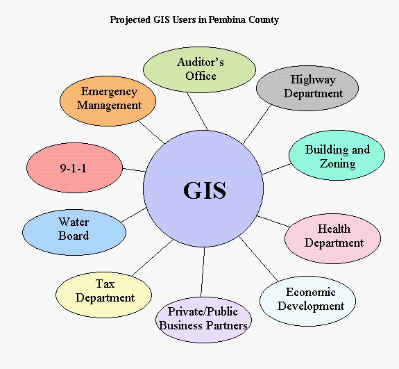
CURRENT PROJECT
We continue to look at how multiple departments within Pembina County
can build upon our base map information to best utilize local resources.
CURRENT PROJECT BENEFITS
Because we have experienced so much in the last several years due to flooding
issues, our county departments and local responders have had to learn to
work together well towards a common goal. This teamwork has continued after
our disasters as we move into recovery and mitigation efforts. This continues
on into the private sector as well as area businesses.
We feel that we have utilized local resources effectively and have tried to look at how what we are doing at this time may help meet future needs. We feel strongly the GIS/GPS information technology is the wave of the future, and is information that will be expected by the public for various uses, such as zoning, building permits, and flood plain administration. We have a commitment to develop and implement digital mapping for Pembina County citizens and effective use of tax resources.
CURRENT PROPOSED PROJECTS
Phase I Project Description:
Our Water Board could utilize the current map layers to add hydrologic
information including legal drains, repetitive loss information from flooding
on those drains, drain topographic information to aide in legal drain management,
and digitized benchmarks for flood projections. When the tax parceling layer
is added, identification of cost sharing when improvements are made on specific
drain areas (special assessments) would improve in accuracy and timeliness.
Our county health department could utilize current data that identifies the
hazardous materials stored in the county to ensure proper planning in the
response and transport of any individuals resulting from an incident have
been addressed. They could also potentially share information (with the
proper release forms signed) that could update our 911 Database to identify
individuals with special medical conditions or needs.
Phase II Project Description
Emergency Management, Flood Plain Administration, Zoning, Building permits,
and the Water Resource Board could utilize additional topographical information
to include road surface elevations, and adjacent ditches. Additional information
could be identified and added to include field drains and natural waterways.
The information could be utilized by FEMA to update Flood Plain Maps and
aid in emergency planning and flood projections.
Further Program Expansion Opportunities:
Pembina County has recently completed our preliminary County Strategic
Plan. This plan has identified a goal of increasing our population by 10%
by the next census in 2010. In order to achieve this goal, economic development
strategies were identified. The Job Development Authority (JDA) will continue
to work towards creating jobs and will monitor results of the strategies.
In all economic opportunities being considered, digitized mapping to show
accurate mapping of infrastructure will aide in selling the area to prospective
new business. Information could include proper property parcels, soils type
identification, floodway boundaries, and accurate power and water line mapping
in addition to transportation routes including road and bridge information,
railroad infrastructure, and airport identification. This could be made
available through either JDA or our Regional Council for recruiting purposes.
In the future, data could be made available from a county website including
these details.
Ideas to enhance our 911 response capabilities could include Automated Vehicle Location (AVL) devices in the response vehicles so that dispatch personnel can track resources. Additionally, our current system will be particularly helpful when Phase II technology for cell phone users becomes available in our state. Phase II information will include a cell phone users phone number, name, and latitude longitude coordinate. We will be able to locate that information at this time with our current technology utilizing our mapping system in dispatch, and send appropriate response personnel.
Proposed Project goals and objectives
Because we are utilizing citizen tax dollars, we strive to effectively
use local resources in the most cost effective manner. We continue to try
to find ways that multiple departments can utilize information and resources.
Digitized Mapping fits in well with our goal of multiple uses for resources.
Description of key personnel
Pembina County Emergency Management/911 Director, Becky Ault, manages
the GIS/GPS Program Administration. The Emergency Management Office maintains
and backsup the system. Liz Beck, Emergency Planner within the department,
will handle the technical aspect of the work, working with our engineers
and making changes and adding information as necessary. Various topographical
data and other pertinent data gathering is contracted. The tax director,
Debra Thompson, works with the parceling and other information related to
her office. She is trained on the system at a technician level as well.
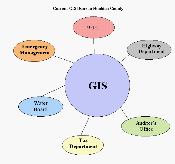
Others using the system include the Public Works Department, Law Enforcement,
Water Resource Department, County Auditor, Health Department, and Dispatch
Personnel.
Description of current hardware and equipment
The county has implemented a TCP/IP peer to peer network. We added a server
to meet existing and future GIS needs (Server: Dual 20 Gb hard drive, 733
Mhz Processor, 256K, NT server). All computer hardware for the system was
already owned and in place in the county (utilizing existing infrastructure).
Other computers connected are (3) 20 Gb hard drive, 1.3 Mhz Processor, 256K
Memory, Win 98 (5) 13 Gb hard drive, 400 Mhz Processor, 128K memory with
Windows 98. We have several printers including an HP DesignJet 50C Plus (wide
format plotter), an Epson color11X17, an Minolta QMS Magicolor 2200 Desklaser,
as well as several black and white printers. Additionally, the county has
recently purchased a state of the art IBM AS400 computer.
DESCRIPTION OF RETURN ON INVESTMENT
The biggest benefit is various forms of information on one GIS mapping
system. We are developing a system at a local level that works in day to
day operations, and continue to share development strategies with other local
entities to create similar systems across the state. Currently, several ND
state agencies are developing themes in ArcView that we have overlaid into
our system, and we have shared some of our information at a state level as
well. By developing a system compatible with the state, the access and utilization
of their data will flow in a more accurate and efficient manner. FEMA ,
USGS, and EPA (among other federal agencies) utilize systems that are compatible
with the system. We can share information which could help in future mutual
aide incidents.
We have a very strong team effort in Pembina County, and digitized mapping
has been a tool that has benefited many of our departments, and will continue
to promote the positive teamwork that has brought us through 9 consecutive
Presidentially Declared Disasters, as well as effectively utilize our tax
dollars because of the multiple uses of the system. We anticipate that ArcView
will meet our current and future needs as we continue to develop our GIS
system. We will continue our team effort, not only at the county level, but
at state and federal levels as well.
ACKNOWLEDGMENTS
Becky Ault is the Emergency Manager/911 Director for Pembina County
since 1995. She is also the Flood Plain Administrator and Co- Risk Manager
for Workman's Compensation Programs. Becky has been working with mapping
and addressing for the county since 1993.
Liz Beck is an Emergency Planner and Mapping Technician in the Emergency Management Department in Pembina County. She began working for the county under a grant in December of 1999. Liz has been trained to work with ArcView mapping software through the Esri Training Center in Bismarck administered by Bullberry Systems, Inc., of Bismarck ND.
Bullberry Systems, Inc. of Bismarck North Dakota is the contractor
for Pembina County for GIS issues. They developed the R3GIS systems software
that is utilized in the dispatch center. They assisted in procuring information
from various sources in addition to contracted work such as conversion
of existing road attributes, address ranges, etc, to GPS collected road
centerlines. They were a critical component in the development of the Pembina
County GIS Multi-Department Project.
Bulberry Systems, Inc.
3237 E Broadway
PO Box 1157
Bismarck, ND 58502-1157
701-255-0076 Main Phone
Mark Luther, Operations Manager
Email: mluther@bullberrysystems.com
Author Information
Rebecca (Becky) Ault, Director
Pembina County Emergency Management/911
308 Courthouse Dr #7
Cavalier ND 58220-4100
Phone: 701-265-4849
Fax: 701-265-4642
Email: rault@state.nd.us