A GIS is being developed to assess habitats and disseminate data for the Oculina Banks Marine Protected Area (MPA). Sidescan sonar imagery from 1995 provides an image of the marine habitats and in May 2002, a survey will collect multibeam echo sounding imagery and sidescan sonar imagery. These images will be contrasted and compared to create a change detection habitat assessment of the MPA. Additionally, digital video from submersible dives (collected in September, 2001), habitat photographs and quantitative data of habitat types and species abundance are currently included in the GIS via GPS collected locations of the submersible vehicle. The GIS application is available both online (www.uncwil.edu/oculina) and via a cd-rom product. The user can query a dive transect for corresponding videos and still photos as well as the traditional GIS layers created from the imagery and attribute databases. To investigate anthropogenic impacts and restoration activities in the MPA, a comparison of historic fisheries information and current conditions will be compared with the change detection image processing results.
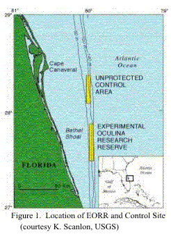
The Oculina Banks extend from Fort Pierce to Cape Canaveral off the eastern coast of Florida (Figure 1). Oculina varicosa, a branching scleractinian coral, forms massive carbonate frameworks throughout this geographic area (Reed, 1980). These coral thrive without the benefit of zoozanthallae, a symbiotic algal species, which benefits growth (Reed, 1980). In 1984, the South Atlantic Fishery Management Council designated a 315 km2 area (79° 56’ W to 80° 03’ W and 27° 53’ N to 27° 30’ N) as a Habitat Area of Particular Concern (HAPC) in which bottom trawling, dredging, and longline fishing were prohibited. In 1994, legislation designated this area as the Experimental Oculina Research Reserve (EORR) and placed more stringent regulations on fishing within the area. By 1995, the reserve was completely closed to all trawling, anchoring, and bottom fishing (Koenig et al., 2000). Expansion of the EORR continued in 2000, with legislation that now protects 1,029 km2 of benthic habitat (Reed in press, 2002).
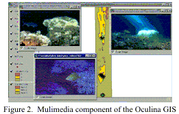
The goal of this study is to create a multi-media GIS for the EORR and to perform a habitat assessment. When completed, the GIS will be available on the Internet for use by resource managers and stakeholders (Figure 2). Current Internet-based GIS applications for marine sanctuaries provide information which is available for download, but lack the interactive map serving capabilities that will be found on the Oculina website.
Unlike marine sanctuaries, the EORR was given an initial ten-year period during which a no-take policy is in effect. This policy will be reviewed in 2004. To make an informed decision on the fate of the reserve, officials from the South Atlantic Fisheries Management Council will use this GIS to analyze the available data. When completed, the GIS will contain habitat maps based on sidescan sonar images from 1995 and bathymetry data surveyed in 1995 and 2002 along with applicable fish count surveys. Georeferenced digital photographs and logs from submersible dives will complete the multi-media component of the GIS.
In 1995, a continuous sidescan sonar image was collected for the EORR and the unprotected control area, located to the north. The data were logged using an ISIS data logging system with a total swath width of 750 meters. The data were filtered and processed to minimize inherit error from beam angle and slant during collection. Digital mosaicking using image-processing software was then used to create a seamless image of the two areas. A spatial resolution of 2 meters by 2 meters was defined and the final image was then projected to UTM (zone 17) with a WGS84 ellipsoid. Error resulting from fluctuating Gulf Stream currents was addressed through the use of sediment samples and remotely operated vehicle (ROV) video footage (Scanlon et al., 1999).
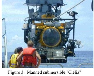
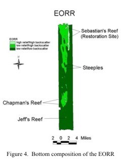
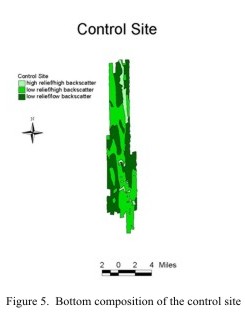
In September 2001, habitat conditions were investigated throughout the EORR and the control site. The research was performed in conjunction with the Sustainable Seas Expedition with primary funding from National Undersea Research Center (NURC) and National Oceanic and Atmospheric Administration (NOAA). During the seven-day mission aboard the research vessel “Seward Johnson II”, investigators from Florida State University, Harbor Branch Oceanographic Institute, NURC, and UNCW employed submersibles to gain an accurate perspective on the current state of the habitat. An ROV (remotely operated vehicle) was used for large scale habitat investigations. The manned submersible “Clelia” (Figure 3) was deployed to carry observers to critical sites (e.g. Jeff’s reef and Chapman’s Reef) within the EORR and control areas (Figures 4 and 5 respectively) for analysis of the habitat. High definition video cameras logged fish aggregations, habitat conditions, and apparent anthropogenic impacts. Tapes from a total of fourteen dives have been reviewed to create a sample set of digital photos and video clips as well as descriptions for each dive.
Data from each dive was imported into the GIS using locally collected GPS locations. Each ROV and “Clelia” dive contains the date, latitude/longitude positions, depth, and investigator comments from the 2001 mission. These files were brought into ArcView (Version 3.2) as event themes and then converted to shapefiles. The shapefiles were then projected using Arcview's Projection Utility into UTM zone 17 with a WGS84 ellipsoid to overlay with the existing sidescan sonar imagery.
Following creation of the shapefile for dive locations, the multi-media links were created. There were several types of ancillary data for each dive site location. Digital photographs collected aboard the “Clelia” were converted from .jpeg to .gif format. Digital video clips and PDF files containing descriptions of the habitats and fish species abundances were also incorporated. The links were established by adding attributes containing pathnames and file names for the video clips, pictures and PDF document files for each site. Linkage of the videos and PDF files required the use of scripts that at the time were available from the Esri scripts home page (http://www.Esri.com/arcscripts) (MPEG Player and PDF Viewer ). The implementation of these scripts allowed for .mpeg (short video clips) and .pdf (Adobe Acrobat) files to be directly linked to the attribute database. When activated, the link launches the Windows Media Player™ or Adobe Reader™ software in a new window, allowing for the material to be conveniently viewed. The linkage of these different file types greatly expands the utility of the GIS application because larger swaths of habitat can be viewed in addition to a full text document detailing the floral and faunal assemblages present within the video clips.
The following configuration was developed to host the IMS web site: Dell Precision 420 running Windows 2000 Server, IIS 5.0, ServletExec 3.1, and ArcIMS 3.1. One of the more complicated software installation procedures, ArcIMS is often a difficult and temperamental beast to not only install but to also keep running when you are in the process of developing the web site. In this project, we have our host website located on the domain of the university ( www.uncwil.edu/oculina ) and the GIS portion of the web site is located on the IMS server ( gisweb.ers.uncwil.edu/oculina ). Part of the difficulty in building an online GIS web site is to have many software components all working harmoniously with one another. Granted, it would be best to develop a web site with personnel who are more experienced with web software! After the site was functioning properly the next step was to develop hyperlinking tools between the dive sites and the pictures and videos. Since the web site uses a custom Java viewer the only method for linking the images and videos was to add an attribute containing the full Internet address for html files containing links to the pictures and images. Unfortunately that linking method requires the user to select (not identify) a feature (e.g. dive site location), list the features selected, and then click on the hyperlink and open an html file with the pictures and corresponding video files. This is a rather cumbersome work-around to a simple task and hopefully this will be smoother in future ArcIMS releases.
The multibeam bathymetric and sidescan survey planned for May 2002 has been rescheduled to a later date in 2002. When completed, this survey will provide a 1m by 1m resolution image of the Oculina Banks habitat. The image will then be compared to the 1995 sidescan mosaic and any changes will be quantified. Georeferenced digital photographs will provide ground-truth information for classifying the habitats (Cochrane and Lafferty, 2002). Locations of these photographs will be used to define a histogram within the sidescan mosiac image containing a range of brightness values representing a particular habitat type. Next, a classification matrix will be compiled where the habitats identified in the digital photographs will be compared with the habitats classified from the 1995 side scan imagery. Any classification conflicts will be analyzed to determine if change has occurred or if the original image was classified incorrectly due to the very difficult conditions in this underwater environment.
To help us identify change in the EORR habitats, fish abundance surveys have been conducted throughout the reef since 1980. While specific methodologies differ over time, surveys performed in 1995 showed disturbing shifts in the ecology of the reef, as smaller fish were more prevalent and overall diversity declined (Gilmore and Jones, 1992; Koenig et al., 2000). The 2001 mission also yielded fish abundances by species for specific geographic locations within the reserve. The resulting database allows users to query individual species by dive location. Generally, these surveys show a continued shift in the community towards nonfishery species. Further investigations are planned to gauge the spawning aggregations which develop during the spring and are essential to maintaining populations of gag and scamp within the reef.
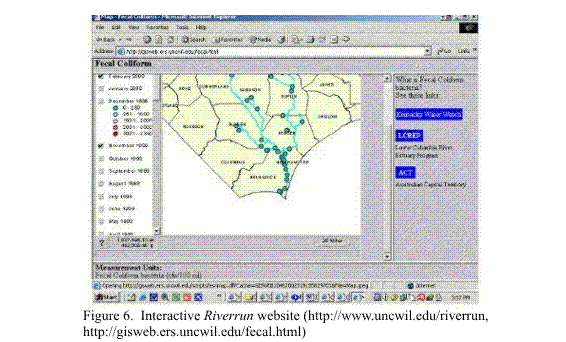
GISs provide valuable tools for analyzing data, which can enable a cost-effective method for assessing and monitoring marine resources. Applications of this software range from site selection of artificial reefs (Wright et al., 1998) to analysis of recreational use trends (Waltenburger and Pickett, 1999). Internet based GIS projects are currently under development for the Monterey Bay National Marine Sanctuary, Channel Islands National Marine Sanctuary, and Fagatele Bay National Marine Sanctuary (Stanbury and Starr, 1999; Waltenburger and Pickett, 1999; Wright et al., 2001). Lastly, in a related project, River Run (http://www.uncwil.edu/riverrun) was created to disseminate water quality data for the Lower Cape Fear River (Figure 6). These projects have demonstrated the utility of GIS and have become excellent tools for achieving management objectives, as well as public education. The Oculina Banks GIS project represents an extension of these efforts, as well as the first attempt to create an interactive GIS for a submerged coral reef system. When completed, the habitat analysis and Internet GIS will provide resource managers with a broad array of data to make sound policy decisions.
The distribution of geospatial data via the Internet is accomplished by developing a client and server-side application structure. The client-side application involves the enhancement of the Web browser to accommodate software that facilitates viewing of the incoming data. Extreme cases require downloading of specific software packages by the user to access the data. Server-side architecture maintains the applicable software and files within the server. In this system, the server processes individual user queries and publishes the results in a format that can be accommodated by generic Web browsers (Marshall, 2000).
The Oculina website is based on a server-side architecture and implements the ArcIMS (Internet Map Server) software. The homepage (http://www.uncwil.edu/oculina) provides an overview of the Oculina EORR and presents information on coral reef ecology and the history of the Oculina Banks. Users will be provided with tutorials that provide instructions on using the mapping software. After entering the mapping environment, the aforementioned data layers will be accessible. Requests by the user will generate a new map that will be provided by the server. The end product will provide stakeholders (policy makers, scientists, etc.) with access to volumes of data on the condition of the reef in one location. This product will represent an improvement in data distribution as current efforts provide insufficient data to support scientific inquiry or educational opportunities.
The CD-ROM product contains the Oculina GIS Arcview project, an attached PDF document to provide technical assistance, and html documents with links to the on-line GIS product. The Arcview project contains the following spatial data layers: bathymetry, dive sites, habitat maps, and fish abundance statistics. Using Arcview's hotlinking tools, the multi-media files are also included on the cd and incorporated into the Arcview product. The CD-ROM will be delivered to the South Atlantic Marine Fisheries Council (SAFMC). The SAFMC will use the project to aid in development of future legislation regarding the HAPC.
The EORR has a historical database regarding trends in habitat and fish stock degradation beginning in 1975 (Reed, 1980). However, even the most recent data can be difficult to assimilate given the variety of sources and authors. The goal of this project is to create a GIS that integrates a variety of data sets that contain information regarding habitat characterization, anthropogenic impacts, fish stocks, and restoration efforts. These data are disseminated via the Internet to users ranging from fisheries managers to the interested public.
Using both Arcview 3.2a and ArcIMS 3.1 this project has successfully created GIS tools that illustrate the multi-media data that are available for Oculina EORR. This project will continue the GIS and remote sensing development through analysis of upcoming multi-beam and side scan sonar imagery. Lastly, a change detection will be performed to determine if creating this protected area and limiting fish trawling has improved the reef for fisheries habitat.
This research was funded by a grant from the National Undersea Research Center (Wilmington, North Carolina). We thank John Reed of Harbor Branch Oceanographic Institute, Christopher Koenig of Florida State University, and R.G. Gilmore for their assistance in compiling the historic data; Jennifer Acuri (NMFS) for fish identification and video editing; and the captains and crew of the R/V Seward Johnson II.
Cochrane, G.R. and K.D. Lafferty. 2002. Use of acoustic classification of sidescan sonar data for mapping benthic habitat in the Northern Channel Islands, California. Continental Shelf Research, 22:683-690.
Gilmore, R.G. and R.S. Jones. 1992. Color variation and associated behavior in the epinepheline groupers, Mycteroperca microlepis (Goode and Bean) and M. phenax (Jordan and Swain). Bulletin of Marine Science, 51:83-103.
Koenig, C.K., F.C. Coleman, C.B. Grimes, G.R. Fitzhugh, K.M. Scanlon, C.T. Gledhill, and M. Grace. 2000. Protection of fish spawning habitat for the conservation of warm-temperate reef-fish fisheries of shelf-edge reefs of Florida. Bulletin of Marine Science, 66(3):593-616.
Marshall, J. 2000. Developing Internet-based GIS applications. 20th Annual Esri International User Conference Proceedings. San Diego, California, June 25-30 2000. Professional paper #405.
Reed, J. 1980. Distribution and structure of deep-water Oculina varicosa coral reefs off of central eastern Florida. Bulletin of Marine Science, 30(3):667-677.
Reed, J. 2002. Deep-water Oculina coral reefs of Florida: biology, impacts, and management. Hydrobiologia. In press.
Scanlon, K.M., P.R. Briere, and C.C. Koenig. 1999. Oculina Bank: Sidescan sonar and sediment data from a deep-water coral reef habitat off East-Central Florida. USGS Open File Report 99-10.
Stanbury, K.B. and R.M. Starr. 1999. Applications of Geographic Information Systems (GIS) to habitat assessment and marine resource management. Oceanologica Acta, 22(6):699-703.
Waltenburger, B. and M. Pickett. 1999. Integration of NOAA aerial monitoring and GIS programs for research, education, and management within the Channel Islands Marine Sanctuary. Proceedings of the 5th California Islands Symposium. Santa Barbara, CA (USA), 29 March-1 April 1999. pp. 469-471.
Wright, R., S. Ray, D.R. Green, and M. Wood. 1998. Development of a GIS of the Moray Firth (Scotland, UK) and its application in environmental management (site selection for an ‘artificial reef’). The Science of the Total Environment, 223:65-76.
Wright, D.J., B.T. Donahue, and D.F. Naar. in press, 2001. Seafloor mapping and GIS coordination at America’s remotest marine sanctuary (American Somoa), In Wright, D.J. (ed.), Undersea with GIS, Esri Press, Redlands, California, 32 pp.
theVal = SELF
' see if the value of the field is not null
if (not (theVal.IsNull)) then
' if the file listed in the field exists, then play the video
if (File.Exists(theVal.AsFileName)) then
' use the path to the video player executable
System.Execute("C:\Program Files\Windows Media Player\mplayer2.exe /play
/close"++theVal)
else
' if the file doesn't exist, tell the user
MsgBox.Warning("File "+theVal+" not found.","Hot Link")
end
end
theVal = Self
if(not (theVal.isNull)) then
isitthere = File.exists (theVal.asstring.asfilename)
if (isitthere = false) then
Msgbox.warning("THE FILE: " + nl + nl+ theVal.asstring + nl + nl +" IS
NOT CURRENTLY AVAILABLE","File not found..")
exit
end
acroc = File.exists("c:\program files\adobe\acrobat
5.0\acrobat\acrobat.exe".asfilename)
if (acroc = true) then
system.execute("c:\program files\adobe\acrobat
5.0\acrobat\acrobat.exe" + " " + theVal.asstring.quote)
exit
end
acrroc = File.exists("c:\program files\adobe\acrobat
5.0\reader\acrord32.exe".asfilename)
if (acrroc = true) then
system.execute("c:\program files\adobe\acrobat
5.0\reader\acrord32.exe" + " " + theVal.asstring.quote)
exit
end
acrod = File.exists("d:\program files\adobe\acrobat
5.0\acrobat\acrobat.exe".asfilename)
if (acrod = true) then
system.execute("d:\program files\adobe\acrobat
5.0\acrobat\acrobat.exe" + " " + theVal.asstring.quote)
exit
end
acrrod = File.exists("d:\program
files\acrobat\reader\acrord32.exe".asfilename)
if (acrrod = true) then
system.execute("d:\program files\acrobat\reader\acrord32.exe" + " " +
theVal.asstring.quote)
exit
end
if ((acrroc = false) and (acrrod = false) and (acroc = false) and (acrod
= false)) then
Msgbox.error("HOT LINK FAILED!" + nl + "Please install Adobe Acrobat
!","No Adobe Acrobat Found")
end
end