Wastewater Flow Estimating
and Planning Tools Using GIS
ABSTRACT
The City of Los Angeles has one of the largest and most complex sewer
infrastructures in the United States. To manage this system, modeling
techniques were developed in 1990 and have proven to be very effective in
supporting short- and long- range master planning (up to 100 years). The model
uses a GIS sewer network, census data, land use, and other planning-related
data for population projections; current and future flow estimates; and data
preparation for dynamic hydraulic models. This presentation shares the
processes of flow estimating and addresses how this model has been upgraded to
Esri's new data geodatabase model and application development framework.
Index:
Use
in wastewater planning process
Alternative
use of population model
Introduction
The City of Los Angeles has one of the largest and most complex sewer infrastructures in the country. City has used GIS to manage and process data for flow modeling since 1990.� This model was one of the first GIS based sewer models developed.� The modeling techniques originally developed were proven to be very effective to support immediate short term planning needs and perform long range master planning, as far out as 100 years.� The model essentially, uses a GIS based sewer network that was designed validated for modeling; census data, landuse and other planning related data sources to estimate current and projected population and wastewater flow estimates.� The primary function of the GIS based sewer model is to provide various planning tools such as; population projections, current and future flow estimates, data preparation and inputs for dynamic hydraulic models, sewer network management. Additionally the model provides potential capabilities to identify strategic flow gauging locations, calibration of estimated flows, managing industrial discharges and general planning� analysis performed in the division.� This GIS based planning tools has provided the City of Los Angeles the ability to manage their large sewer system in effectively and timely manner.
With the new technologies made available with the current versions of ArcGIS, and the City�s commitment to this model, an upgrade to this model was required that is compatible to ArcView 8.2.� This upgrade provides better data management and data processing capabilities, a better user interface, and provides an upgrade path to future versions, including the opportunity to use a Geodatabase data structure and added functionality.� One of the greatest benefits is the enhanced integration of all aspects of the model into a user interface that planners and engineers can use.� The previous model required higher level GIS expertise.� The upgraded application is developed using ArcObjects,Visual Basic and Visual C++ and deployed as an ArcView 8.2 extension.� The enhanced model is referred to as the Sewer Flow Estimation Model (SFEM)
This presentation shares the application architecture and model functionality developed for the project. Experiences and technical challenges from upgrading from an ArcInfo based model to an ArcView 8.2 model will be shared. The presentation also provides insight to various techniques using GIS based tools to plan and manage large sewer infrastructure and effective use of the CENSUS data using GIS based modeling techniques.
Background
The City of Los Angeles is effectively using GIS in the wastewater planning process for data management and complex analysis. Original wastewater flow estimation model was developed over ten years back and is still� used today. The modeling techniques used have proven to be very effective in supporting immediate planning needs and perform long range master planning. The core model was developed in ArcInfo 6.x using AML programming. The function of the core model was to trace and define basins on the sewer network and estimate flows using standard practices adopted by the City. CENSUS population and projections was one of the primary input to the model, which were pre-processed outside the GIS portion of the model. Additional analytical functionalities were developed outside the model to support planning process.
With changes in technology and a need for added functionality, the City decided to upgrade the existing model. The upgraded model uses the basic model concepts from the previous AML version while adding some enhancements in data resolution.� The upgraded model provides an integrated solution using newer software tools providing access to planners and managers.� All componets of population projections, flow estimation and modeling are incorporated into one application.
Key project goals
The model design and development was defined to accomplish some key objectives. The following are the key objectives defined for the model:
q Integration of model components: Integrate data processing, modeling, analysis and reporting into a common application� providing seamless integration among various model components
q Added functionality: Develop enhancement to data management, analytical and reporting/mapping functionality
q Improved user interface: Develop easy to use user interface providing more access to the model for planners and managers. Develop standard maps and reports creating standards for planning process
q Newer technology and application architecture: Application design and development using ArcGIS and geodatabase concepts. Provide flexibility to accommodate future changes in data structures
q Improved data management: Design strong data management concepts to accommodate large data sets with varying formats and ability to manage various planning scenarios
Application architecture
The application was developed using ArcObjects to work as an ArcView 8.X extension.� This allows the user all the functionality of mapping and the GIS processing and analysis with the modeling functionality.� The majority of the application was developed with Active X DLLs with some proprietary routines developed in Visual C++ for sewer tracing and tributary basin definitions.
The database sources to the model can be in shapefiles, coverages and tables in DBF format.� The application performs system checks on the data and converts all input data into a single Personal Geodatabase.� The application was developed to eventually accept Geometric Networks data for the sewers, but is current designed for shape and coverage formats for the sewer network with little modification to the application code.� Using a personal geodatabase as a model database, provides efficient data processing and controlled version control for model scenario file structures.���
�
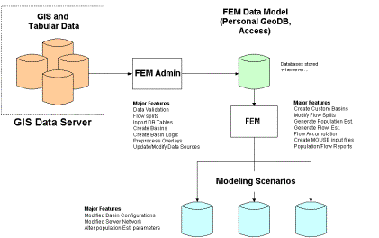
Application modules
The SFEM application is broken down into two separate ArcView extension, the SFEM Administrator and the SFEM Modeler.� This two tiered application approach provides efficient data processing and distribution tool sets the appropriate end users.
SFEM Administrator
The primary purpose of the SFEM administrator is to provide tools for the higher level GIS and data processing for building a database that has been tested and validated for the modeler module.� The basic data processing performed are data validation on the input data, processing of short and long term population and other preprocessed data and defaults parameters to the model.�� The idea is to do as much �heavy� processing on data that is more static and leave the faster �what-if� scenario processing for the end user.� Most of the data inputs to the model are fairly static and only change on an infrequent basis.�
Summary
of Database Design
SFEM Modeler
Using the data processed in the SFEM Administrator, the modeler
does not have to worry about data format and content and can do what they
do best.� Since all the major data
processing is performed up front in the administrator module, the user can
create many multiple scenario configuration very quickly.� The modeling can literally estimate flow one
or many locations in literally minutes.� This
rapid processing provides a modeling environment that promotes exploration
of alternative scenarios.
Data architecture
The data structure was designed to provide file management
and three functional levels.� 1) Data
Processing and validation from a master SFEM dataset, 2) User Model from a
copied SFEM dataset allowing user level modifications to data parameters and
settings, 3) Model runs, applying flow estimation time periods.� Each of these database structures are based
on personal geodatabases
Personal Geodatabase
The personal database was used as the database design because of it�s data organization and ability to use standard database development tools in Visual Basic.� Using� a personal geodatabasse in MS Access format offers database processing in using SQL statements which are extremely efficient and easy to develop.�� At the user level, the administrator and modeler can mange more than 20 data layers and tables in one singe data structure. �Since all the data is packaged together, the personal geodatabase provides assurance that all the data stays together is consistent with each other.�
Raster Based Approach
The SFEM model is based on using raster processing and data structures.�
Using the raster format, large amounts of data can be processed very
accurately.� The distinguishing factor of this model from
other population models is the use of raster data for performance and higher
level analysis capabilities.� The previous
model and others typically use polygon overlay processing for data distribution.�
Since the SFEM model needs to process data at the census block level,
performing traditional polygonal overlay processes is not reliable due to
the error in sliver processing and round off errors.�
Using raster data, provides a very refined model at sub census block
resolution (typically 100sqft in SFEM) that is extremely accurate.
Model functions
The key concepts described here are not a complete representation
of the application functionality but it highlights the key concepts of the
model. The three primary model components are data processor, population model
and flow estimation model.
Data Processing
The data processor is a wizard with user-friendly data captures screens combined with error trapping and validation routines. The processed data is stored in structured geodatabase, which is used by various model functions. The processor also captures various administrative logs providing administrator a useful debugging and management capabilities. The data processor is primarily used and� designed for administrator with GIS background� The tools provide error trapping routines in both tabular and spatial data that are required the application design and essential reliable results produced by the model.� Errors reports are generated, that are accessible by ArcMap that can be linked for spatial reference in research and correcting the errors.
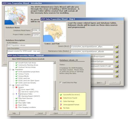
Data Processing Tools to validate and build Model
Dataset
Population Model
The population model uses regional population projection data from the Southern California Association of Governments (SCAG), SCAG landuse, City General Planning Landuse, Census tract and Census block data.� All the data inputs to the population model are consistent with other planning activities within the City.
The major objectives of the population model are:
� Build near term SCAG population projections out 25 years
� Build long term using near term and growth rates factors out 100 years
� Apply population to service areas, clipping data to service area boundaries
� Apply population to areas served by sewers considering open space and non-sewered areas (septic)
� Process population for every 5 year increment and interpolate between years as needed for specific analysis
The approach used in this model is unique from others in that it applies population to areas served by sewers.� The population is more accurately applied to a collection system by distributing the census block population into non openspace.� An example of this is shown below:
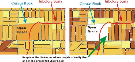
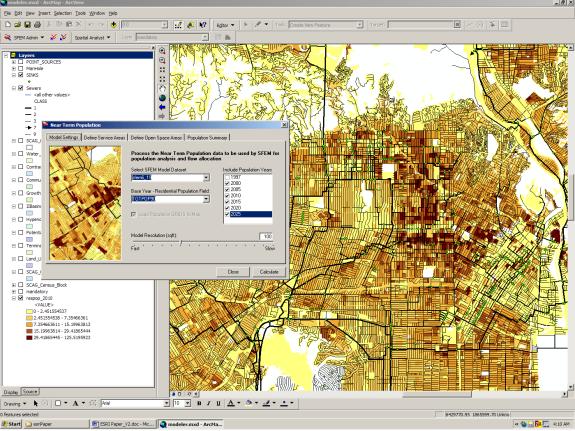
The SFEM administrator module processes near term and long term population with a interface for changing input data, selecting population ranges and the processing of open space areas.� Residential and employment population grids are created for each year selected.� These population grids become the input to the SFEM modeler.� Since population is stored in raster grids, the modeler can readily apply population to flow estimation very quickly to their model.� As seen the screen shot below, all population is pushed into areas of non open space defined by the SCAG landuse layer.� This puts residential and employment population where the people are and where wastewater flows are generated.
Residential
Population Estimate for year 2010
Flow Model
The modeler uses the data processed in the SFEM administrator, including population data for estimating flows in the collection system.� The flow model uses industry standard engineering concepts for flow estimation by defining tributary basins and estimating flows within these basins.� The user has the flexibility to change flow variables to meet the local conditions.� The flows can then be used for various planning activities including static flow accumulation or linking to hydraulic models.
Basin Generation
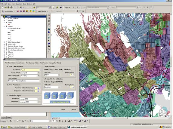
The using the SFEM modeler application, the planning can define the study and tributary areas specific to the needs of the study.� Tributary basins are defined by SFEM using tracing and basin generation tools.� Essentially, the user can select any combination of sink nodes on the sewer network to define tributary basins.� These basins are generated using raster processing allowing population and flow to be summed to basin using Grid Zonal operations.� The SFEM modeler application user friendly interface for defining these basins.
Flow Estimation
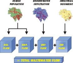
Flows are estimated using 4 main components, residential flow, employment flow ground water infiltration and inflow and industrial point sources.� Using raster processing these flow components can be calculated and accumulated to tributary basins.� The total waster water flow values can then be used for planning or linked to a hydraulic model for further analysis.
Wastewater flow estimated applied to tributary basins
Use in wastewater planning process
The use of SFEM functionality goes beyond it�s intended purpose.� The tools available in SFEM allows additional use of the model.� The following are some of the uses in sewer planning process:
q Population:
o Distribution for short-term and long term horizon
o Analysis and comparison on growth over time
o Covering City and contract agency areas
o Analysis of various growth scenarios
q Current and future flow estimates
o Flow estimates for master plans and localize study areas
o Treatment plant and pumping plant study area analysis
q Data preparation and inputs for dynamic hydraulic models
q Sewer network management
q Alternative analysis
o By changing current configuration
o By adding new sewers and diversions
q Additional use of the model
o Identification strategic flow gauging locations
o Calibration of estimated flows
o Managing industrial discharges
o Downstream and upstream traces on sewer network
o
Treatment plant location analysis
Alternative use of population model
The tools developed in population model are based on generic datasets. The primary input to the model is CENSUS block and tract level GIS coverages. The model has processing routines to take these CENSUS block and tract level residential and employment information combined with other user inputs and distribute the dataset to finer resolution using grid processing.
This population distribution model can be used in city planning
process at various level. The model can be used as is with no modification
if applicable or can be modified with minor changes to meet the local planning
concepts. The examples of the planning efforts could be; water planning, transit
planning, real-estate analysis, and more.
Conclusion
The custom GIS application tools developed to support wastewater-planning process is proven to be effective on providing analytical strength to the end user without requiring extensive GIS background. Strong data processing component built within application model offers quick upgrades to model inputs without requiring time consuming preprocessing.