Enhancing Transit Planning and Decision-Making
Via GIS Technologies
Author: Jakob Helmboldt
Abstract
GIS technology is helping to integrate decision-making at the GRTC Transit System. This paper examines the development and implementation of GIS technology in a mid-sized transit agency. The paper highlights how GIS and GPS capabilities allow for new perspectives on the planning process for transit applications and the analytical tools that such technology provides. This paper looks at how GIS has changed and/or enhanced the planning process for amenity enhancements, resource allocation decisions, route analysis, demographic-based decision making, project management tasks, and customer service improvements.
Introduction
The GRTC Transit System is a mid-sized transit provider serving the Richmond, VA metropolitan area. The GRTC Transit System provides fixed-route bus service to the City of Richmond and portions of Henrico County and Chesterfield County via a fleet of approximately 180 buses. Our fixed-route buses provide approximately 4.8 million miles of service annually via 56 separate routes and provided over 9.7 million trips in fiscal year 2001.
Since June of 2001, GRTC has also operated the Chesterfield LINK, a "deviated fixed-route" service that ties into existing fixed-route bus service through the use of 17 body-on-chassis shuttle vans to serve the majority of routes in Chesterfield County. This service complements the fixed route and paratransit deviated-route vehicles that serve Richmond and Henrico.
The GRTC Transit System contracts out welfare-to-work transportation services via C-VAN, the Central Virginia Area Network, with 37 vehicles, and paratransit service for elderly and disabled through the CARE-Van service (Community Assisted Ride Enterprise) with 42 (wheelchair) lift-equipped vans.
Finally, GRTC’s sister agency, RideFinders, provides rideshare services that connect commuters with carpools, vanpools and transit services while also promoting other alternative transportation options. This has made the GRTC Transit System the transportation provider for the Metro-Richmond area.
The GRTC Transit System has an annual operating budget of approximately $26 million and was ranked as the 12th most efficient transit system nationally in a recent University of North Carolina at Charlotte study. Peer performance analysis has ranked GRTC as number one in three categories; Passengers per Revenue Mile, Passengers per Revenue Hour, and Total Cost per Passenger. It is notable that GRTC has not had a fare increase, or a service reduction, since 1993.
Implementing GIS at GRTC
The GIS implementation project at GRTC Transit System commenced in the winter of 2000. Previously, all GIS services were outsourced either through a consultant or through the MPO. At the time of commencement the only existing layers were outdated route shapefiles provided by the consultant.
Through data-sharing arrangements with the City of Richmond and Henrico County GRTC obtained street centerline files for initial base-mapping purposes. By using their centerline files we were able to recreate our route shapefiles, updating them in the process and having more complete address ranges and other attributes included in their data.
GPS Data Collection
One of the biggest and most important tasks has been, and continues to be, the collection of bus stop data. We use a Leica GS50 GPS to conduct field data collection. At this point 99% of our 2500 fixed-route stops have been completed. Once finished we will proceed with the collection of the Chesterfield LINK stops which consist of approximately 300 additional locations.
Initial Uses of GIS at GRTC
The initial plans for the use of GIS at GRTC was to have the data management and analysis functions as well as mapping functions in-house that had previously been outsourced. By collecting all bus stops and their attributes we will be able to have a complete inventory of all current bus stops as well as the attribute data pertaining to each location. In the process we have been able to update the many records and files that pertain to bus stops. This has allowed us to cull from our lists outdated information, redundant stop listings, and helps to ensure the accuracy of turn sheets and stop lists (for each route) and other data pertaining to routes and stops.
The GIS function is housed in the Planning Department of GRTC and it was determined that GIS would prove to be a highly useful tool in the planning process. As more data and layers are built into the system the potential for more rational and accurate planning will be realized.
Even prior to having completed the bus stop data collection, the analysis capabilities have proven to be a significant asset in the decision-making and planning process. Numerous requests for amenities and service improvements at bus stops come from both citizens and Richmond City officials. With finite resources the judicious distribution of items such as shelters, benches and trash receptacles is imperative. Where previously it was necessary to manually search through several lists of data to determine all relevant information we are now able to use the GIS in this capacity. Not only is all of the data available at the click of the mouse, but various parameters can be set and queried all in one simple process. Add to that the visual component that allows users to see the locations without having to leave their desk, and the process of determining resource allocation is expedited many times over.
By linking existing data such as passenger counts for bus stops GRTC has been able to access and manage data much more easily than in the past. Using our data in conjunction with U.S. Census data we have been able to perform a host of functions from determining the optimal locations for amenities to performing proximity and buffer analysis to determine if we are adequately serving our customers.
Project Management and Bus Stop Maintenance Capabilities
Project management and maintenance issues have been simplified through the use of GIS. As part of GRTC’s branding campaign, new signs were installed throughout the City of Richmond. This project coincided with the bus stop data collection. This provided the added benefit of being able to collect information relating to incorrect installations. Problems were categorized and noted in the Leica GS50 and repair reports were generated and forwarded to the installation contractor. Maintenance issues can also be queried and stops requiring attention can be forwarded to GRTC’s Maintenance Department for service.
GRTC will soon be preparing an amenities plan for our entire system. Using the GIS we will be able to allocate resources to each council district within the city based upon proportional needs. The use of GIS allows us to query stops by district, summarize the passenger activity within each district, and summarize the amenities currently allocated to each district. This information will allow us to not only allocate resources to the most beneficial locations, but will also allow us to proportionally and equitably distribute our resources throughout the City of Richmond.
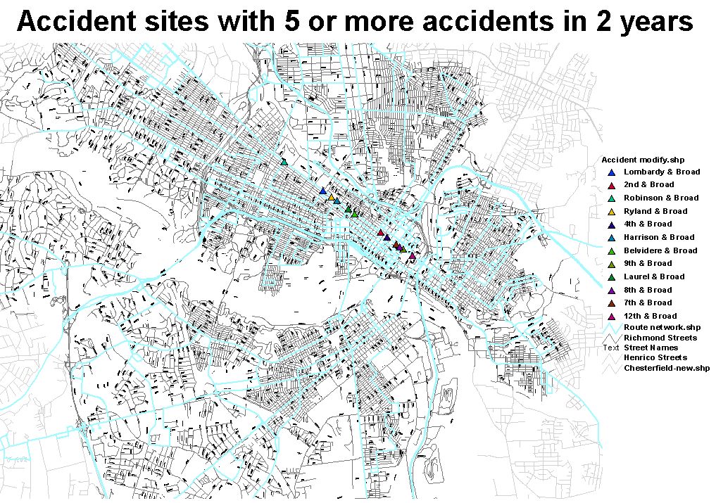
Things That Go Bump in the Night
A recent spike in accidents prompted GRTC management to begin scrutinizing accident data in an attempt to determine what may be some causes. As a result more complete data will be collected in future accident reports which can then be imported into the GIS for analysis purposes. Some preliminary analysis has been done and accident sites for several of the "hot spots" in our service area have been identified and geocoded. As more data is compiled GRTC will be able to use this in conjunction with GIS to more thoroughly evaluate accident statistics.
New Route Creation and the Review Process
New routes and changes to existing routes are a frequent issue within a transit provider. Preparing documents that detail such changes need to be prepared for municipal officials and for public review and approval. Having the ability to produce maps and supporting documents in-house simplifies and expedites the process. Having high-quality visuals to present with the documentation has enhanced our ability to communicate ideas and changes and has resulted in a greater "buy-in" from the parties affected by proposed service changes.
Federal Reporting and Compliance
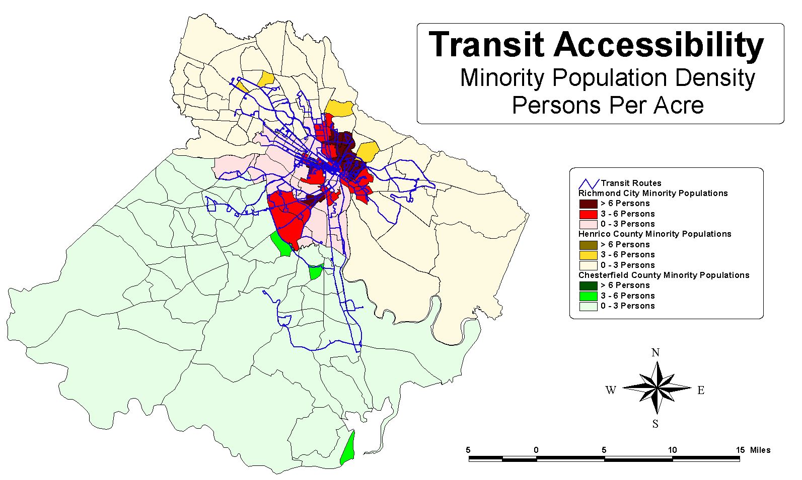
Previously, GRTC has had to outsource GIS services used in preparing Title VI reports sent to the Federal Transit Administration. With Traffic Analysis Zones and Census shapefiles shared with us by local jurisdictions and the MPO we have been able to do density analysis and prepare maps indicating that minority populations are adequately served by GRTC’s route network.
Getting People Out of Their Cars
RideFinders has recently purchased an ArcView-based ride-matching program from GIS-Trans, which allows them to more accurately match commuters interested in alternative commuting options. As we develop layers related to our service we can integrate them into their ride-matching system, making their ride-matching solution more complete. From park & ride lots to bus stops and routes, the information we develop will allow us to offer better service to our customers.
We have also begun using the GIS to geocode addresses of state employees who have expressed an interest in using GRTC bus service for their commute. After geocoding we are able to perform proximity analysis to determine which employees are good candidates for using bus service. Our Customer Service Department can then provide them with more complete route information based on our findings. This function will be augmented with Network Analyst by allowing us to determine actual distances and routes to bus stops or park & ride lots for these potential customers, thereby increasing the likelihood that they will find the service an attractive alternative to their current transportation.
The Future of GIS and GPS Technology at GRTC
As we continue to develop our database of information and attributes we will be afforded more analytical capabilities for problem solving and planning. We will also continue to add more tools such as Esri’s Network Analyst Extension. We will also be utilizing GIS in a number of other departments, either via internally developed applications or via products produced by Esri partners.
Currently GRTC is investigating a host of GIS and GPS-based technologies and applications that will allow us to offer better, more efficient service to our customers, and hopefully attract new customers as well. Our Scheduling Department is in the process of researching their best solutions for run-cutting software, and our Customer Service Department is looking to acquire trip-planning software.
Though well down the road, GRTC is contemplating long-term solutions that rely on GIS and GPS technologies. Online trip-planning features will be integrated into our website and eventually we plan to implement an AVL system for use on all vehicles. This technology offers not only benefits to the customers by giving them real-time information, it provides invaluable information to the Planning, Scheduling and Operations Departments and it is updated continually. No longer will we rely on data that is outdated or based upon weighted averages (such as passenger counts). Instead we will have virtually all of our spatial data available at the click of a mouse, updated continually, giving us the best opportunity to provide the best possible transit service to Metro Richmond.
Jakob Helmboldt
Transportation Planner/GIS Coordinator
GRTC Transit System
Richmond, VA, 23220
804-358-3871 x339
804-342-1933
jhelmboldt@ridegrtc.com