By Peter Pace
Over the past ten years, Fort McClellan Army Base in Alabama has invested in the development of a GIS system to support the Base Realignment and Closure (BRAC) process. The GIS were recently consolidated into a single system. To keep pace with developing technologies Fort McClellan embarked on a conversion from Coverage format to a GeoDatabase system compliant with the Corps of Engineers SDSFIE data standard. The previous system consisted of over 3 gigabytes of data including coverages, shapefiles, images, and grids. The process for creating the GeoDatabase and converting the data will be discussed with lessons learned during this effort.
Fort McClellan, located near Anniston, Alabama, has an interesting history that dates back to the Spanish-American War. Originally known as Camp McClellan, the Camp trained over 27,000 men for the Great War.Later, the Fort trained nearly 500,000 men for World War II. The local mountains provided a natural backstop for an assortment of types of firing ranges.After several specialty functions, in 1995 the base was designated for closure by the Base Realignment and Closure (BRAC) committee. The land is being transferred to various public and private uses.
The transfer of this land requires careful recording of environmental monitoring and infrastructure changes. Towards this end, both the Directorate of the Environment and the Alabama National Guard maintained GISs.Basemap data were derived from interpretation of ortho-rectified aerial imagery.Ancillary GIS was collected by GPS.These data were then entered into an ArcView GIS system.The primary use of the GIS was cartographic output in order to support environmental and infrastructure decisions.
The original “core” GIS data were structured in a format compliant with the commonly used Tri-Services Data Standard.The “core” GIS files were stored in Arc/Info coverage format. Ancillary shapefiles necessary for the various mapmaking tasks were stored in the user’s working space on their own computer. Individual users could map to colleague’s computers in order to share data but data security and versioning became an issue.
Recently, Fort McClellan’s GIS capabilities were upgraded to ArcGIS.Therefore, the GIS files had to be migrated to a geodatabase structure in order to maximize the use of ArcGIS. This paper deals with the migration of the “core” GIS files from Arc/Info coverage format to a geodatabase in Spatial Data Structure for Facilities, Infrastructures and Environment (SDSFIE) format.
The SDSFIE standard was developed by the CADD/GIS Technology Center for Facilities, Infrastructure, and Environment (formerly the Tri-Service CADD/GIS Technology Center). Its charter establishes a multi-agency vehicle to coordinate facilities, infrastructure, and environmental use of Computer-Aided Design and Drafting and Geographic Information Systems (CADD/GIS) activities within the Department of Defense (DoD) and with other participating governmental (federal, state and local) agencies, and the private sector. This includes setting standards for GIS databases. In support of these standards, several computer tools were developed by the CADD/GIS Technology Center for migrating data into their standard database structure. More information about the standard, related tools, and the CADD/GIS Center can be obtained at: tsc.wes.army.mil.
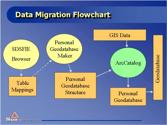
The migration of the Tri-Service Standard Arc/Info coverage GIS data into the SDSFIE standard geodatabase format required careful planning and the use of several software tools.The figure below illustrates the flow of information/files between the three software routines.The dashed arrow lines represent the flow of knowledge while the solid arrow lines represent the flow of electronic data.The software routines are depicted as oval shapes in the diagram.
The first step in the migration process was to become thoroughly knowledgeable of the data.All GIS files, including associated attribute tables, to be migrated were listed in a Microsoft Access table as shown below:
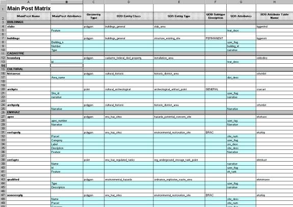
Once the coverages and attributes were listed, the associated SDSFIE tables and fields were determined. To help determine the mappings between the coverages and the geodatabase, the CADD/GIS Center developed a software tool called the SDSFIE Browser. The browser was used to complete the SDSFIE-related columns in the mapping matrix shown above. It was important to make the correct mappings and to check that the related fields were compatible. Several coverages had to be reorganized in order to fit the SDSFIE requirements.
The SDSFIE standard has a huge library of tables and associated attributes intended to hold most possible facilities, infrastructure and/or environmental GIS data requirements. Usually only a small fraction of the possible SDSFIE tables are required. To filter out unneeded tables from the SDSFIE standard, the CADD/GIS Center distributes a filter-making tool. This tool prompts the user to select those tables that are needed and builds a filter file. Despite the advantage of creating a re-usable filter, it was decided not to use the filter-making tool. It was found that a customized database structure could be more easily and accurately built using the knowledge embedded in the mapping matrix from within the Geodatabase Maker tool.
Using the Geodatabase Maker, created by the CADD/GIS Center, the personal geodatabase structure was created. The Geodatabase Maker tool prompted for the required SDS Entity Types, and the map projection and the spatial extents/spatial resolution of the entire database. The Entity Types were listed in the mapping matrix and easily entered into the tool. The coverages all had the same projection and the associated projection files were stored in each coverage folder. The tool structured this information into an empty personal geodatabase.
Once the structure of the personal geodatabase is created, ArcCatalog was used to import the coverage data into the database. Using the mapping matrix as a guide, the operator selected which SDSFIE table in the personal geodatabase to open and then navigated to the corresponding coverage data. Once all the data had been loaded and checked for spatial accuracy, metadata was entered into ArcCatalog for each GIS file. >Using ArcCatalog, the personal geodatabase was copied, feature class by feature class, to a geodatabase. Fort McClellan was now able to start taking advantage of ArcGIS and the geodatabase format.