Maj Michael Thomas
Lt Col Billy Asbell
Dr. Melinda Higgins
Mr. Nick Faust
National Guard GIS and Related Technologies for Counterdrug Law Enforcement
The National Guard Bureau Counterdrug Office (NGB-CD), through their Technology
Programs, have over the past several years implemented an innovative blend of
GIS, digital mapping, enhanced visualization, virtual reality, electro-optics,
sensor fusion, modeling and simulation, data acquisition, and other operational
assessment technologies. These programs support and incorporate NGB-CD assets
such as their Digital Mapping Center (DMC), aerial reconnaissance platforms,
law enforcement training centers, and Nationwide counterdrug task forces. This
presentation will provide an overview of the many National Guard GIS Technology
programs in operation and the extensive collaborative environment supported.
NATIONAL GUARD COUNTERDRUG PROGRAM
The United States National Guard Counterdrug Program (NGB-CD) is a national
counter-narcotics program utilizing the National Guard membership in major communities.
This program provides highly skilled personnel, specialized equipment, and facilities
to support counterdrug law enforcement agencies (DLEAs) and community based
organizations to better respond to the changing drug threat in our Nation. Since
1989 the National Guard has been supporting law enforcement organizations in
their efforts to counter the drug threat in the United States. On any given
day the National Guard Counterdrug Program has over 3,000 Guard personnel on
active duty nationwide supporting the all fifty states and four territories
with counterdrug programs. These efforts include providing personnel, training,
facilities, assets, knowledge, methodology and access to emerging technologies
such as geographic information systems (GIS), remote sensing image processing,
and global positioning systems (GPS).
GIS Initiatives Overview
NGB-CD through its Counterdrug Geographical Regional Assessment Sensor System
(CD-GRASS) program has incorporated and collaboratively networked many technologies
including a Decision Support System (DSS) fusing GIS, operational intelligence,
historical mission data, and remote sensing imagery to support counterdrug operations;
a Digital Mapping Server (DMS) incorporating ArcIMS (Internet Map Server) for
dedicated mapping and GIS support to NGB-CD and drug law enforcement agencies
(DLEAs); GIS support to counterdrug law enforcement through NGB-CD's Digital
Mapping Center (DMC) and counterdrug GIS training (CD-GIST) program, as well
as other technology evaluation tasks.
DMC (Digital Mapping Center)
The digital mapping center (DMC, formerly known as the digital mapping initiative,
DMI) has been in operation since 1992 providing DLEAs with free computer generated
mapping products custom designed for their needs and applied to everything from
mission planning to intelligence analysis. Maps are produced from digitized
data provided from numerous sources. Map products can be produced in a variety
of scales from 1:2,000,000 to 1:24,000 or larger for customers with local interests.
Products can be provided showing terrain features, aeronautical information,
rivers, lakes, counties, cities, roads, highways, latitude-longitude grids,
towers, and more. In addition, maps can be customized to include arrest statistics,
seizures, marijuana growing statistics, etc. Location data (either GPs or latitude-longitude
information) for customized maps must be provided by the requesting client,
who can obtain the coordinates from many sources including autonomous handheld
GPs units. Street-level mapping products derived from US Census Bureau TIGER
data can also be provided at scales of 1:12,000 to 1:10,000. All products are
provided free of charge for a counterdrug mission. In fiscal year 2000, the
DMC provided fifty thousand pages of maps to their clients. The largest group
of users is state and local law enforcement agencies, which requested fifty
percent of their production. [For more information, please see http://www-cddmi.forscom.army.mil/]
CD-GRASS (Counterdrug Geographical Regional Assessment Sensor System) Program
The National Guard Bureau Counterdrug Office (NGB-CD), through the Counterdrug
Geographical Regional Assessment Sensor System (CD-GRASS) program, lead by the
Georgia Tech Research Institute, is incorporating an innovative blend of GIS,
digital mapping, enhanced visualization, virtual reality, electro-optics, sensor
fusion, modeling and simulation, data acquisition, and other operational assessment
technologies. The mission of CD-GRASS is information integration, assessment,
and decision support to counterdrug operations through state-of-the-art technology
transfer. The CD-GRASS program also incorporates National Guard Bureau assets
including their Digital Mapping Center (DMC), aerial reconnaissance and sensor
deployment, law enforcement training centers, and 54 state and territory counterdrug
task forces. In addition to supporting GIS technology enhancements for DMC,
the CD-GRASS program has two additional GIS focused efforts: a counterdrug Decision
Support System (DSS) and a Digital Mapping Server (DMS) portal.
DSS (Decision Support System)
As part of the CD-GRASS program, the National Guard Bureau Counterdrug Office
(NGB-CD) has also funded the University of Southern Mississippi's Center for
Higher Learning (USM-CHL) to design and build a Decision Support System (DSS).
The goal of this DSS is to develop a system that will increase the efficiency
of the planning and conduct of marijuana eradication operations. The ultimate
users of the DSS will be the State DLEAs, and the National Guard Counterdrug
personnel in support of counterdrug operations. One of the fundamental problems
relating to the eradication of marijuana cultivated outdoors is the size of
the search area relative to the available resources. The 'heart' of the DSS
will be a rule-based expert system module that identifies areas with a high
potential for marijuana cultivation.
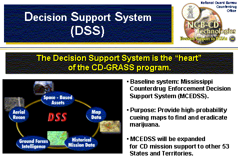
Figure 1: Decision Support System (DSS) Concept
The DSS will have a single headquarters node consisting of a cluster of servers
and workstations that access and process data to produce a suite of map layers.
The primary map layer will provide verification of geographic areas with the
highest likelihood of marijuana cultivation sites. This layer will be the
output of a rules-based expert system. The decision layer, supplemental map
layers, and other information will then be distributed to law enforcement
agencies via an Internet-based communications network. Field nodes (aircraft
and ground-crew laptop computers) will also be able to download this information
at a district office via the network for use during their search/eradication
operations in the field.
DMS (Digital Mapping Server) Portal
To address the extensive spatial land attribute data requirements to support
a GIS environment, the Digital Mapping Server (DMS) portal has also been initiated.
This technology is based on current Commercial and Government initiatives
underway such as the Geography Network, the Open GIS Consortium, and FGDC
I-team initiatives. This system will allow all levels of users to access GIS
data from verifiable sources via the next generation of Internet by simply
querying DMS. This is the primary GIS backbone of the CD-GRASS program.
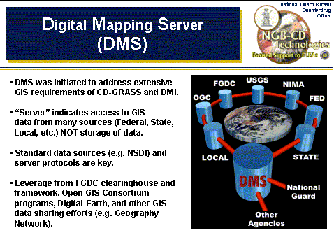
Figure 2: Digital Mapping Server (DMS) Portal Concept
CD-GIST (Counterdrug Geographic Information Systems Training)
In addition to DMC and the CD-GRASS program, the National Guard Bureau has
begun the Counterdrug Geographical Information Systems Training (CD-GIST) Initiative
to address GIS training requirements. CD-GIST focuses on training law enforcement
professionals on related aspects of GIS principles and software. Through the
efforts of the Federal Law Enforcement Training Center (FLETC), the four NGB
schools and the National Guard Bureau Environmental Programs Division (NGB-ARE),
law enforcement officers and staff will learn how GIS can assist them in their
mission. Participants will also learn how to use the most common commercially
available GIS software. With support from the DOJ/NIJ Crime Mapping Research
Center (CMRC), this program is destined to change the way DLEAs maintain historical
documentation and the methodology they use to conduct investigations and operations.
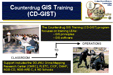
Figure 3: CD-GIST Focuses on GIS Principles and GIS Software
and Leverage Many Partnerships
Other Related Technologies
The National Guard Counterdrug Office is also pursuing a number of additional
technologies to support law enforcement which also have some connection to GIS
activities. One of the many services NGB-CD provides counterdrug law enforcement
is the evaluation of currently available products that may be acquired to increase
their capability as well as effectiveness. Some of the technologies evaluated
and operationally integrated to date include:
- the evaluation of the combined LEICA VECTOR Binoculars with GPs for automated
coordinate capture of remote targets;
- evaluating potential systems and the technology required to upgrade current
wet-film imaging capabilities on-board the counterdrug C-26 aircraft to digital
formats;
- reviewing communication and video transmission requirements for direct downlink
from the C-26 aircraft to ground units including overlaid sensor and map information
in real-time; and
- integrating moving map technologies to work in concert with the decision
support system being deployed currently in Mississippi.
Collaborative Efforts
The success of the CD-GRASS program, the Digital Mapping Center and the National
Guard Counterdrug programs overall are due to partnerships and collaborative
efforts with over 21 Federal, State, and local law enforcement agencies, Universities,
and non-profit organizations. In 2002 NGB-CD is expanding the success of CD-GRASS
program into the "NGB-CD Technology Consortium," which will foster
collaboration among of a wide variety of agencies to enhance counterdrug law
enforcement operations. The presentation of this paper will highlight the technology
support to law enforcement provided by these programs through geographic information
systems (GIS), training and applications to field operations. [See http://ngbcdtech.gtri.gatech.edu
for more information.]
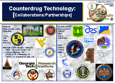
Figure 4: The Many Partnerships of the National Guard Counterdrug Programs
Major Michael Thomas
Technology Projects Officer
National Guard Bureau Counterdrug Office (NGB-CD)
Lt Col Billy Asbell
Deputy Chief Special Projects Division
National Guard Bureau Counterdrug Office (NGB-CD)
Dr. Melinda K. Higgins
Counterdrug Geographical Regional Assessment Sensor System (CD-GRASS) Program
Manager
Georgia Tech Research Institute
Mr. Nick Faust
Associate Director for Georgia Tech GIS Center
Technical Director for the CD-GRASS Program
Georgia Tech Research Institute