Paper No:
776Title: GIS FOR MILITARY PLANNING
Author
Barbara Hough
Butch Folsom
Abstract
Responding to a multitude of concerns while meeting mission requirements with dynamic funding is a daily challenge. Geographic Information Systems (GIS) enable planners to establish development directives while using decision-making tools that allow for viewing, measuring and querying of the Common Installation Picture (CIP). This paper will focus on the use of GIS to support the rapid creation of superior plans. Specific examples using ArcView and ArcIMS to evaluate opportunities and constraints, communicate development staging and1391 generation will be discussed.
Introduction
Future development plans for military installations are the product of the analysis and synthesis of information from a variety of related, yet independent sources. Evaluating opportunities and constraints requires that a multitude of maps, plans and databases come together. The process of locating accurate data and gathering drawings from different organizations is often confusing and time consuming. Translating this information into a common and useable format also complicates the process. Geographic Information Systems (GIS) allow this information to be viewed from a single reference point. Ready access to these maps and the associated information contributes to the rapid creation of superior plans. This technology enables planners to establish development directives while using decision-making tools that allow for real time viewing, measuring and querying of opportunities and constraints.
The planning process can be integrated with GIS technology and Esri products to deliver an electronic plan. There are many benefits that are realized from using this technology. Some of these benefits include: updated spatial data that is verified with planners in the field, superior plans that are generated with consideration of all geographic impacts, and the ability to manipulate the plan using GIS tools after delivery. This paper will discuss these benefits while describing the planning process in detail.
Benefit 1: Spatial Data Verified
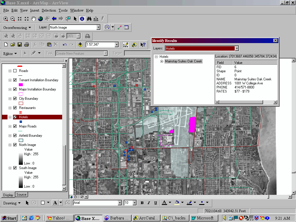
Initially, the planning team visits the installation to determine the status of existing conditions. The quality of this data is critical because this information is used as a baseline to generate requirements for the installation by comparing existing assets to authorizations as determined by the appropriate handbook. All identified deficits and excesses of area provide the foundation for the plan. Typically, surpluses are allowed to remain unless an advantage can be gained in relocating the function that would outweigh the costs and disruption created by the move. Deficiencies are identified in order to generate action that would remediate the shortage in the most economical fashion. During the course of this trip, maps, plans, and data are gathered and verified to ensure that the planners are generating requirements that are as accurate as possible. Developing this situational awareness is only one facet of the information that is acquired to support the planning process. An example of additional data gathered and delivered includes the development of GIS data as the trip is planned. Information about the locality to include hotels, restaurants, local roads, municipal boundaries and more is generated to prepare for the visit and support the Vicinity and Regional Maps that are deliverables. While on site, data is created as well as gathered. This is a result of building assessments to identify operational or conditional deficiencies, interviews with every organization and discussions with the local community to identify any issues that could impact long-range plans. All quality military planners will be collecting, verifying and developing this data. The benefit of having this data delivered with the plan is often overlooked by the installation. This can be a cost-effective method to enhance data maintenance routines. To maximize this benefit, it is important to have the contract language reflect the format specifications of the data, related database structure, and metadata requirements.
Figure 1: GIS data development begins before the initial site visit.
Benefit 2: Superior Plans
After the field survey, requirements are generated. Requirements are the facility authorizations that determine the space needs for all functions on the installation. This process illuminates excesses and deficiencies of space according to function as identified by category code. This information is reviewed along with interview data and infrastructure condition assessments. As the planners begin to identify what the installation needs, GIS is used to solidify projects. Maps and plans are delivered to GIS staff for updates. This information is consolidated into an Opportunities and Constraints map. The time spent in the field ensures that this map clearly and accurately portrays this information at a concentrated level of detail. Constraints can include Cultural and Natural Resource (CNR) concerns such as wetlands, flood plains, or historic sites. GIS analysis is used to develop other constraints that rely on buffering analysis. Some of these constraints include imaginary surfaces of the airfield like Accident Potential Zones (APZ’s), and Building Restriction Lines (BRL’s). Force protection setbacks and Explosive Safety Quantity Distance (ESQD) arcs for buildings containing explosives are other examples of constraints that are visualized through GIS processes. These are all examples of elements that can be prohibitive to development. Opportunity areas are typically those areas unaffected by constraints and unoccupied by other facilities or activities. However, facility realignment and renovation can also be considered opportunities.
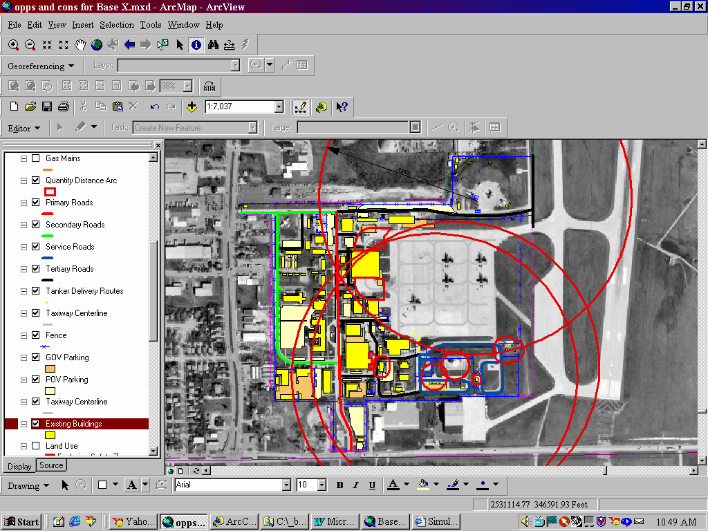
Figure 2: Opportunities and Constraints define project placement.
GIS data supports viewing the topography of constraints in order to quickly and easily identify where NOT to place projects. The real benefit to planners is the capability to view any combination of spatial data and assess other impacts to development. For example, after using buffering tools against an aircraft parking area, the Effective Concrete Pavement (ECP) is instantly evident. A facility violating the BRL is clearly identified as a result of a simple query and the GIS can be used to identify the occupants and condition of the building through associated data collected during the initial site visit. It may be decided that this building should be torn down and replaced. In order to determine the optimum placement for the new facility a planner will want to turn on utility data, contour data, land use zones and any other features that affect implementation. The planner will use the database to identify the occupants and function of the surrounding buildings. It is a simple matter to turn these themes on and off and use the ID tool in ArcView to perform this analysis. It is also very helpful to use GIS functions to measure distances and drag a graphic that represents the relative size of the new facility to potential locations.
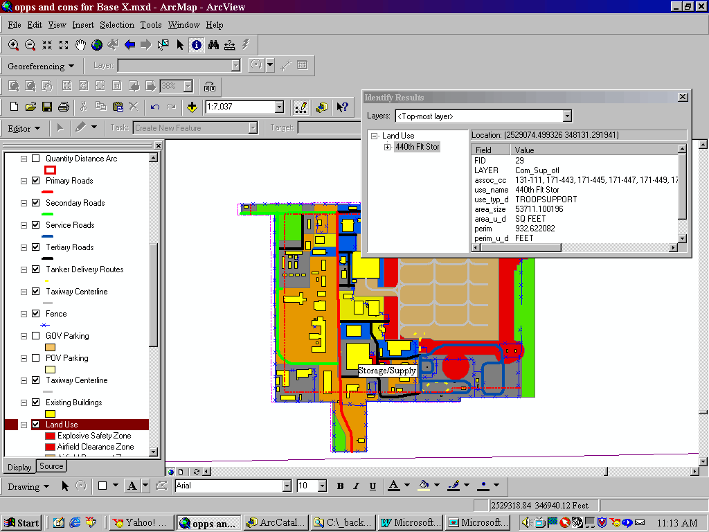
Figure 3: Not only are all pertinent maps layered in a manner that allows for ease of analysis, associated databases make related information instantly visible.
These tools result in superior plans that reflect what an installation needs with little or no surprises upon implementation. To take full advantage of GIS as a planning tool, it is important to realize the importance of accurate data. The plan is only as good as the data used to support analysis. Metadata is essential to provide information about the age, source and anticipated level of accuracy of the data.
Benefit 3: Electronic Plans
When GIS is used throughout the planning process it is not difficult to deliver this plan as an ArcView project file or Internet Map Service (IMS), as well as the standard hard copy. Cartographic techniques can be used to ensure that the display of the plan utilizes the same color and linestyle standards of any traditional paper deliverable.
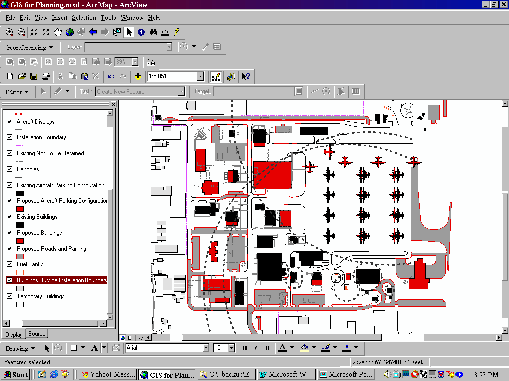
Figure 4: Cartographic techniques can be used to employ planning standards for symbology.
There are several benefits to having your plan delivered in this manner. First, project staging is improved. A "mouse-over" function can be set to display any project predecessors. These numbers display a recommended sequence of events that reflect priorities and minimize disruption on the installation caused by demolition and/or construction. The ability to view predecessors and access the related project descriptions provides the flexibility to respond to funding opportunities while staying informed of the impact of implementing projects out of sequence. This information can also be used to communicate construction and demolition plans to personnel that would be affected, and alternate traffic routes with projected dates for impact can be communicated with output documents from the electronic plan.
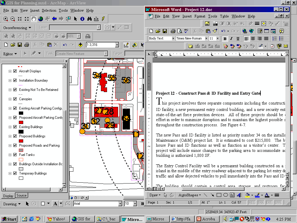
Figure 5: Hyperlinks to project summaries can be established.
Another benefit can be realized by using the GIS and electronic plan to support the generation of 1391’s. The DD Form 1391 is used by the Department of Defense to submit requirements and justifications to congress in support of funding requests for military construction. Project summaries should be written up with photos or map inserts to display the project area as a part of the planning deliverable. These documents can be hyperlinked to the projects in the long-range plan, and the project summary can be placed in the layout with the view from the data frame. Finally, text, charts, tables and graphics can be added to create a 1391 that will make a strong impression.
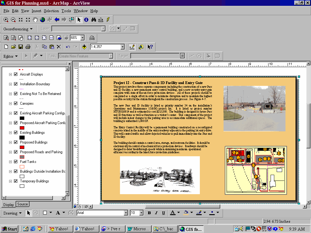
Figure 6: ArcMap tools support 1391 generation.
Perhaps the most important benefit of having an electronic plan is simply the ability to view and track these projects within a GIS. This allows the plan to be updated much easier than a paper notebook. To exploit this investment, a plan for the data itself should be established and followed. While all viewers of the GIS will be drawing from the same data, specific personnel will be responsible for ensuring that the data is current. Ownership of the data should be assigned and a maintenance plan implemented. Once a logical organization is named responsible for a feature or features, the data will reside where they can easily access it with "read/write" permissions excluding others from manipulating it. All projects that involve spatial data should be reviewed to ensure that the contract language specifies that the deliverables include GIS files with specifications for format and metadata. Without a plan in place to support data maintenance, an electronic plan will quickly be out of date and will find its place on the shelf next to the paper deliverable.
Barbara Hough
GIS Project Manager, URS Corporation
9960 Federal Ave. Suite 300
Colorado Springs, CO 80921
719-268-7421
Butch Folsom
HQ AFRC/CEVX
BCP/GeoBase Manager
255 Richard Ray Blvd.
Robins AFB, GA 31098
COM: 478-327-1067
DSN: 497-1067