Status of GIS Education
The Higher Education Institutions in the United States
Halil I. Tas
Though some studies have been done, there are many gaps to fill in GIS education at higher education institutions in the United States. The expectation of the business world, individuals, government offices, and universities on GIS education is unknown. Whether the types of university and GIS programs (correspondence GIS education, certification, and degree programs) have any relationship to one another is not known it is essential, however, to know the current trends to make a proper prediction for the future of GIS education. This paper compares universities using the Carnegie Foundation's classification and analyzes the types of GIS programs based on students, targeted markets, and GIS service areas.
Over the past fifteen years, the growth in the development, acquisition, and implementation of Geographic Information Systems (GIS) has increased, and GIS has become a large industry in the United States alone, being utilized by the private sector, the public sector, and in academia. Since the use of GIS has been growing rapidly, many practitioners seek basic and advanced education and training.Thus, many vocational schools, community colleges, four-year colleges, and universities try to adopt some GIS courses.However, increasing the capacity of educational programs does not solve the problem of new demands on GIS education.
Because GIS is very broad, tremendous effort and research since the 1990s has not been enough to identify clearly what GIS education is and the application of its many different aspects.Most of the time, educational institutions developed and offered GIS programs in order to provide GIS experts to the public. It is unknown whether a relationship exits between the local population and institutions offering GIS. What is the relationship between the spatial distribution of GIS education institutions and the type of GIS education?In addition, how the size of the academic institution affects the size of GIS education in the institution is not known.
This paper is to identify the current status of GIS education in the geography departments of universities in the US and to analyze and determine the GIS at different higher education institutions.
Studies on GIS Education
A great deal of effort has been devoted to the search for a model for GIS instruction. Universities and professional organizations have organized conferences related to GIS education at the university and K-12 levels.The weaknesses and strengths of the GIS programs in colleges and universities have been discussed many times, especially at undergraduate and graduate levels.
Dahlberg (1983) explained cartographic and geographic information systems education in the United States as a "pancake with bubble" model. The pancake represents the introductory level of courses in GIS, which are offered in many colleges and universities.The surface bubble represents the places where advanced courses are offered.He also notes a pyramid structure with more intermediate courses.
There are many driving forces for GIS education today. Government initiatives, threats of competition from related organizations, and leadership interests in establishing benchmarks of performance are just a few of the driving forces.At the same time, more attention is focused on the competence of the employees, which can be solved with certification).
Obermeyer (n.d.) reports that several academic institutions have already established GIS programs. Some universities were both pioneers in teaching GIS (Harvard University), and developing early GIS programs.In Great Britain, Edinburgh University was the pioneer in GIS education. In Canada, the Department of Geography at the University of Western Ontario was the first institution to offer formal GIS education.Some universities in the United States and the UK offer degree programs in GIS.There are few educational institutions where GIS programs have been offered for many years in the United States; however, many universities started GIS education in the second half of the 1990s. Many universities did not have the capability to support GIS course work and very few were able to support a large multiple curriculum in Cartography, Remote Sensing, and Geographical Information Systems (Aageenbrug 1992).
Types of GIS Education
There are different types of GIS programs, which have been commonly applied by academic departments.
Short Courses and Workshops
Short courses and workshops were common during the early period of GIS growth and mostly provided by vendors and universities (Wikle 1998). They are organized for explicit goals within a short time frame.Most of the time, those activities do not have any prerequisite courses.Employers often assign short courses during the hiring process in order to give information about the software programs that employees will use.
Distance GIS education
Distance learning is becoming popular in GIS education in the US, Canada, and Europe. This is a relatively new learning method for those who do not have the opportunity to attend a scheduled GIS course. Wikle (1998) states that students who registered in distance GIS education take a sequence or group of courses on an independent basis that is often counted towards a GIS diploma.Students can follow the course by video or Internet by way of "facilitating self-paced instruction."
Certificate Programs
Certificate programs are defined as programs, at accredited colleges and universities that constitute a sequence pattern or groups of core developed, administrated, and evaluated by faculty or faculty approved professionals (Smith 1987). Long (1992) defines a certificate program as "a non degree sequence, patterns or group of instructed sections that focus on area of specialized knowledge or information that is developed, administrated, and evaluated by the institution's faculty members or by faculty approved professionals" (p.17).By the 1990s, more than 600 colleges and universities had certificate programs in different subject areas (Henderson 1995).Like degree programs, certificate programs need to be approved and supervised by a university or college (Wikle 1998). Certificate programs have some advantages for universities and colleges in attracting new customers (students and business contracts) and by increasing the ways that institutions can meaningfully serve business and industry (Robinson 1991).
Certification in GIS
According to Obermeyer (1997), certification is a process in which a �candidate meets a specified set of criteria defined by a certification board.� Wikle (1998) defines the focus as being on �explicit, measurable outcomes that require an individual to demonstrate competency and mastery of a body of knowledge through an examination or peer evaluation process.�Likewise, certification is an indication that professionals or employees have a certain level of experience and knowledge about the topic.
Degree programs in GIS
A few universities offer degrees in the GIS.For example, Texas A&M University at Corpus Christi initiated a Bachelor of Science in Geographic Information Science.On the other hand, a number of universities and colleges outside of the US offer degree programs in GIS, such as Canada, the United Kingdom (Edinburgh University and Leicester University), Austria (Curtin University), New Zealand (Massey University), and Australia.
Morgan et al. (1986, 1992, and 1993) has done some of the most important studies on GIS education in higher education. They show that the numbers of departments that offer GIS and GIS-related courses has been increased each year. They have conducted many surveys on GIS education. The results showed that only fifty-four percent of the geography departments offered GIS courses. The most important problems that departments had were the lack of staff and interest. The results also showed that the content of the academic GIS courses varied widely. The nature of geography, geographic data collection, geographic data analysis, geographic data display, and types and uses of GIS were common aspects of course curricula.Seventy-five percent of the departments surveyed showed that they did not have any prerequisite courses.
According to 1993 survey by Morgan (1993), more than 650 colleges and universities in the United States and Canada offered at least one GIS course.Although geography departments have offered most of the GIS courses, GIS courses were available in many different departments, such as Civil Engineering, Urban and Regional Planning, Agronomy, Forestry, and Landscape Architecture. Goodchild and Kemp (1992) write that GIS courses have become a common component of the undergraduate program, especially in geography departments.
Problems in GIS Education
Colleges and universities face many different problems when they decide to offer GIS courses.
1 The cost of software: Even though new technology gives an opportunity to reduce the cost of software, some software programs are still too expensive for some departments.
2 The cost of hardware: It is hard to buy sufficient computers and computer related-hardware for academic departments because of their budgets.
3 The cost of software/hardware maintenance: Contracts are too costly for some small departments.
4 The lack of faculty educated in GIS.Most departments have just one faculty member who teaches GIS related courses.
Current Trends
A study was conducted by the author using census data (2000), a survey to geography departments at four-year higher education institutions, and Carnegie Foundation�s Higher Education Classification.
According to Carnegie Classification of the Higher Education Institutions, the number and the percentage of the GIS institutions shows different characteristics (Table 1). The majority of the Geography Departments offer GIS at the master�s and Ph.D. levels (144 out of 237).Only ninety-three institutions offer geography at Bachelor level alone.As can be noted from the table, the four-year institutions offer GIS a much higher percentage then two-year colleges (only 7.5 %).In addition, Research Universities I & II (DE & DI) offer the majority of the GIS programs (52%). A lower percentage of the GIS programs are offered at small colleges because they may have more financial, technological, and academic challenges. Thus, this information provides a better understanding of the patterns of the type of the Higher Education Institutions and GIS education.
Table 1
Number of the GIS programs at different Higher Education Institutions in the US.
|
Carnegie Classification* |
Number of GIS Programs |
GIS programs (%) |
|
DE |
89 |
37.55 |
|
DI |
36 |
15.18 |
|
AC |
1 |
0.42 |
|
BG |
6 |
2.53 |
|
BL |
10 |
4.21 |
|
M-I |
89 |
37.55 |
|
M-II |
3 |
1.28 |
|
SO |
3 |
1.28 |
|
Total |
237 |
100 |
*DE: Research Universities-Extensive, DI: Research Universities-Intensive, AC: Associate Colleges, BG: Baccalaureate Colleges�General, BL: Baccalaureate Colleges�Liberal Arts, M-1: Master�s Colleges and Universities I, M-II: Master's Colleges and Universities II, SO: Specialized Institutions-Other specialized institutions.
Spatial Distribution of GIS Institutions
GIS education has different characteristics between the geographical divisions. According to this table 2, the majority of the GIS institutions are located in Pacific Coast, West lakes, and Southeast divisions. Southwest division, on the other hand, represents the lowest ratio. In addition, Northeastern United States and Lakes Regions show an evenly distributions and scattered GIS offering Institutions. Great plain and southwest divisions are large in size but the population density is low when it is compared with other regions. Thus, it is logical to see the numbers of GIS institutions are quite low (14%).
Table 2
���� The Spatial Distribution of the GIS Education by Regional Divisions
|
Regional Divisions* |
Number |
Percent (%) |
|
Pacific Coast Division |
37 |
15.61 |
|
Great Plains-Rocky Mountains |
19 |
8.01 |
|
Southwest |
15 |
6.32 |
|
West Lakes |
44 |
18.56 |
|
Southeast |
44 |
18.56 |
|
Middle Atlantic |
10 |
4.21 |
|
Middle States |
32 |
13.53 |
|
East Lakes |
17 |
7.2 |
|
New England- St. Lawrence Valley |
19 |
8.01 |
|
Total |
237 |
100 |
*Regional division in the table is derived from Association of American Geographers (AAG).
The Size and the control of the Geography Programs offering GIS Education
The Geography Department offering GIS shows different characteristics as size and the Control of the academic department. Almost sixty percent of the geography departments (combination of masters and Ph.D. programs in geography) offer GIS education offer graduate studies in geography(Table 3).
��������� Table 3
Profile of Geography Departments Offering GIS
|
Programs |
Frequency |
Cumulative Percentage |
|
Bachelor in Geography |
93 |
39.2 |
|
Master in Geography |
80 |
33.8 |
|
Doctorate in Geography |
64 |
27 |
|
Total |
237 |
100 |
The Control of the Institutions
The majority of the Private Institutions offering GIS are in Northeast and West Lakes division (Table 4). More than half of the private institutions are Doctorate Research I & II universities while nearly 40 percent of these private institutions offer Geography at graduate level (masters & doctorate). Some of these private Institutions have long and strong educational reputations in the US history such as, John Hopkins University, George Washington University, Syracuse University, and Clark University.
Table 4
|
Control of The Institution |
Number |
Percent |
|
Private |
29 |
12.24 |
|
Public |
208 |
87.76 |
|
Total |
237 |
100 |
Carnegie Classification provides some further insights in to the spatial distribution of the GIS institutions. Southeast division has the highest Doctorate-Research institutions while Middle Atlantic division has the lowest. Pacific Coast, West Lakes, and Middle States have similar characteristics on the number of the master�s colleges. AC, BG, BL, and SO colleges have similar dispersion and scattered almost all divisions.��
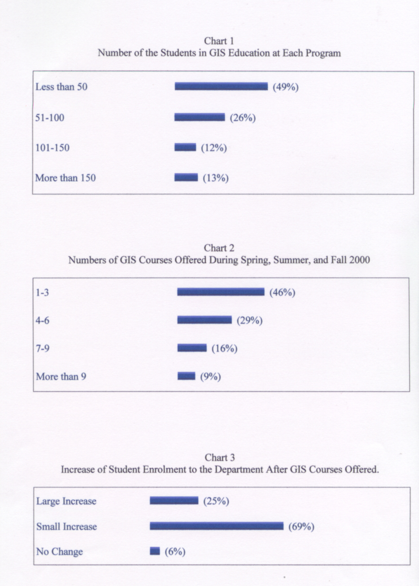
Almost half of the geography departments offering GIS education have a small number of students in GIS courses while one fourth of the institutions have between 50 and 100 students (Chart 1).
Institutions having large GIS programs are all public institutions. All programs having more than one hundred student in GIS are Doctoral Research Universities except for six institutions that are Master Colleges and Universities-I. Four of the large GIS programs were offered at bachelor level only.
The number of the students and courses offered in geography programs show identical results (Chart 2). Similar to the student profile, almost half of the institutions offered at most four GIS courses in last one year (2000). Programs offering between four and six courses were classified as medium size programs (more than twenty five percent).
The impact of GIS education on Geography Departments
The overwhelming majority of institutions agree that GIS education has increased enrolment in their programs (ninety-four percent). However, the majority of the geography programs report that GIS programs caused small increase in enrollment while twenty-five percent of them report that GIS has made a larger increase in student enrollment (Chart 3).
Distance GIS education is quite new and very few institutions offer it. Only five Geography departments surveyed offer Distance GIS education (six percent). All geography departments offering distance GIS education are offering masters or doctoral diploma and the institutions are either doctoral research universities or master colleges.
Types of GIS Applications
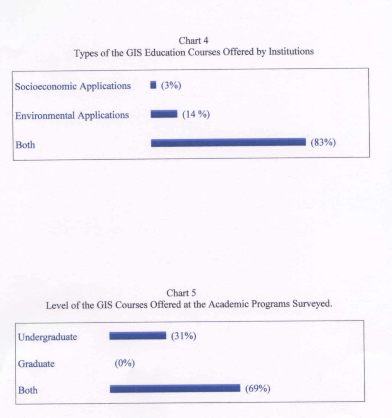
According to the survey result, most academic departments offer GIS courses in both socioeconomic (vector base) and environmental (raster base) applications (eighty three percent). Only three institutions offer courses in socioeconomic applications alone (three percent) while Environmental applications alone were offered by only fourteen percent (Chart 4).
Level of the GIS courses offered
The majority of the Universities offering GIS education are doing so at both the undergraduate and graduate level (69%) while only 31 percent of the academic programs offered undergraduate level (Chart 5). There is no institution offering only graduate level GIS education.Six out of twenty-nine private institutions offer only undergraduate GIS education while twenty-three public Institutions offer undergraduate level GIS education. The institutions offering only bachelor level GIS Education are mostly small colleges, M-I and some D-I institutions according to Carnegie Classification.
There are few institutions offering Ph.D. programs in GIS. Though there may be many institutions offering GIS emphasizes in GIS, they do not offer Ph.D. in GIS but Geography.
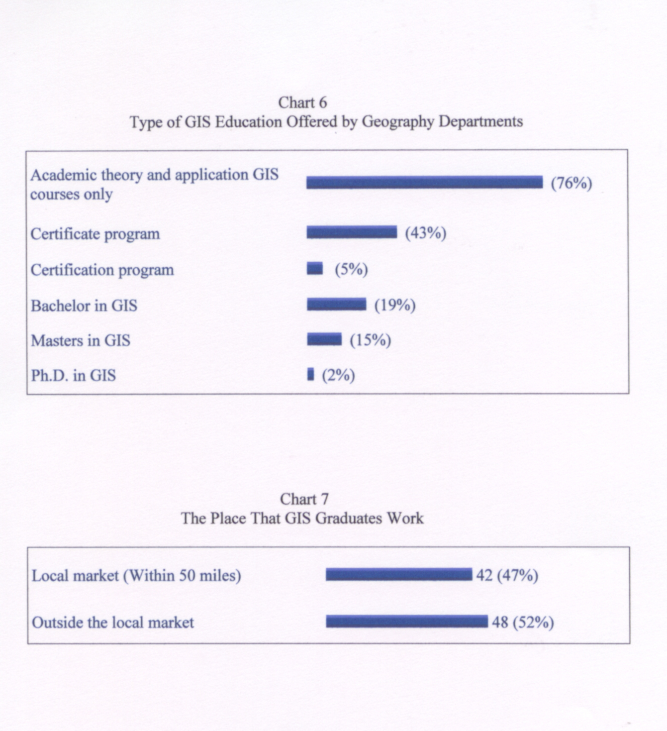
According to survey result, the types of Institutions offering GIS certificate programs are mostly research-I and II universities. Almost half of the Certificate programs are offered in Research I (DE) Universities. The rest of the certificate programs are offered research II universities, M-I Colleges and others.
Service areas of the GIS institutions
According to the survey results (Chart 7), almost half of the institutions reported their GIS graduates work in the local market (forth-seven percent). The types of the institutions (Carnegie Classification), control of the institutions (Public and Private), regional distributions, and offering degree in geography departments shows similar characteristics.���
The mobility of GIS graduates also shows varying characteristics. Only two institutions, having more than ten million local population, report that their graduates work in local market (California State-Long Beach and California State-San Bernardino). These two institutions are in the heart of large populations with a significant GIS business opportunities and employment bases. However, there is a tendency that institutions having less local population send graduates to work outside of the local market.
Table 5
The type of the GIS offering institutions and the number of the students
|
Carnegie Classification |
More than 50 Students |
Less than 50 Students |
|
DE |
25 |
6 |
|
DI |
9 |
7 |
|
AC |
0 |
1 |
|
BG |
0 |
2 |
|
BL |
0 |
3 |
|
M-I |
13 |
23 |
|
Total |
47 |
42 |
The majority of research universities have a large amount of students in their GIS programs. Seventy-two percent of Research I and II Universities had more than fifty students while twenty-seven percent had less than fifty students.On the other hand, only thirty seven percent of the master colleges had more than fifty students in their GIS programs. Most of these programs were located in West Lakes, Southeast, New England, and Pacific Coast regions.
Findings
Doctoral/research universities (including DE & DI) had more and larger GIS programs than baccalaureate and master�s colleges.
Most graduate programs were in research universities while undergraduate programs are in small size universities.
Socio economic and Environmental GIS applications were offered equally in the GIS programs.
After offering GIS courses, most of the time, the enrollments of an academic department increased.
�Although distance GIS Education is still premature and few programs offer, it has been offered mostly by large research universities since they have more support personnel and facilities.
Institutions usually designed GIS programs are not specifically for the local needs but to teach the fundamentals of GIS. Institutions located in rural area or in urban areas offered similar curriculum programs in GIS.
Most graduates serve the local market in large populated areas while less populated areas GIS graduate either worked in local market or left for outside of local market.
Conclusion
The spatial distribution of GIS education shows an even distribution nation wide. The major effects on the distribution are the size and the population of the divisions. East and West Coast, specifically North Eastern and the Lakes regions have majority of the GIS offering institutions. Most of the GIS programs are at graduate level though undergraduate GIS education is also relatively high (forty percent).
Though GIS programs show similarities in curriculum between institutions, the type of the institutions show different characteristics. Most of the Research-extensive, Research-intensive Universities and Master Colleges offer GIS education while most of the community colleges and other two-year colleges did not involve GIS.
References
Aangeenbrug, R. T. (1992). Editorial. International Journal of Geographical Information Systems, 6, 263-265.
Dahlberg, R. E. (1983). Structure and context of cartographic education in the mapping sciences in the United States. International Yearbook of Cartography, 20,151-159.
Goodchild, M. F. & Kemp, K. K. (1992). GIS accreditation: What are the options? ACSM Bulletin.
Henderson, C. (1995).Undergraduate certificate programs of less than two years. Research briefs 6, American Council on Education, Washington, DC.
Long, H. B. (1992). Trends in non-degree certificate programs: A national survey. Continuing Higher Education Review, 56, 59-69.
Morgan, J. M. et al. (1986). Academic directory of GIS education, Dubuque, IA: Kendall Hunt.
Morgan, J. M. (1986). Academic geographic information systems education. Address unanswered questions. Geographic Information System in Government, 2, 887-893.
Morgan, J. M. & Fleury, B. B. (1992).Academic GIS Directory: GIS in Higher Education. Geo Info Systems.
Morgan, J. M. (1993). Academic GIS education. Geo Info Systems, 3 (4) 33-40.
Obermeyer, N. J. & Onsrud, H. J. (1997). Educational Policy and GIS: Accreditation and Certification. UCGIS White Paper on Accreditation and Certification for GIS.
�Obermeyer, N. J. (n.d.). GIS Certification and Accreditation: An idea whose time has come.
Robinson, J. H. (1991). The economics of geographic information system. New Directions for Adult and Continuing Education, 52, 33-42.
Smith, A. O. (1987). The relationship of age, sex, education, experience, income, and field preparation to job satisfaction of university career certificate graduates.Unpublished doctoral dissertation, School of Education and Human Development, George Washington University.
Wikle, T. A. (1998). Continuing education and competency programmes in GIS. Int. J. Geographical Information Science, 12(5), 491-507.
Author Information:
Halil I Tas
Department of Geography
Oklahoma State University
Stillwater, OK 74078
E-mail: thalil@okstate.edu