
Larry Herd, lherd@pixxures.com, Vice President of Internet Business, Pixxures, Inc., 15000 W64th Avenue, Arvada, CO 80007 (303) 302-8600
Abstract
This paper describes the processes, challenges, and solutions associated with online delivery of continental coverage of multiscale imagery. The need for timely and immediate mapping information to address the ongoing business decisions necessary to meet the challenges of today's environment, is critical to a company's success. This presentation will show the integration of an image delivery technology with the Geography Network to meet today's demands for rapid delivery of critical mapping information.
Introduction
Pixxures, Inc. has developed an Internet-based Image hosting and delivery service called the WebPix Portal, which delivers ortho-corrected satellite and aerial image data to ArcView 3.X users and the Geography Network on demand. The WebPix extension provides the user with options to access geopositioned imagery on their local disk resources or directly from the Internet through the Pixxures WebPix Portal. A seamless image library is housed in the Pixxures hosting facility, sold on the basis of subscription or transactions and managed through an electronic commerce.
Pixxures’ WebPix technology allows the ArcView 3X and ArcGIS user to define the exact location, area and ground resolution of the image data to be accessed in real time.
Pixxures has acquired several key data layers to provide seamless imagery coverage: DigitalGlobe’s Landsat7 Millennium Mosaic 15m color satellite, AirphotoUSA 1m color ortho coverage of 50+ USA metropolitan areas, Russian 1m military satellite coverage of several metro areas and the entire USGS 1m color, color infrared and black and white Digital Ortho Quad library, totalling more than 30 terabytes of image data.
As an Esri Alliance Business Partner, Pixxures’ strategy incorporates the Portal into two Esri technologies - the ArcVIEW 3.X platform and the new Arc 8.X technologies, including the Geography Network. Behind the "portal" and invisible to the user is a combination of ArcSDE, Axion compression and decompression technology, and Enterprise Java Beans in a facility of web servers, disk arrays and e-comm engines. This paper discusses the methodologies used, the challenges encountered and solutions selected in developing and implementing this Web-enabled system.
Pixxures, Inc. is an orthoprocessing, hosting and Internet delivery company providing real-time Internet access to a commercial image server facility.
Why the Need for a Centralized, Internet-based Image Delivery System
The planning, organization and management of most land-use related projects requires accurate, complete and current maps illustrating the topography and surface features whether man made or natural. This information is invaluable for activity planning and operations, engineering, public consultation and more recently, position-specific information gathering. All aspects of surface activity from planning through operations to asset management rely on the use of accurate spatial data to provide a clear picture of the surface environment prior to, during and after any surface operation.
The adage "a picture is worth a 1,000 words" is most applicable to a map. Conventional line maps, particularly of a technical nature, often lack identifiable detail in order to simplify presentation and be legible. Conventional line maps are often difficult for the inexperienced map user to orient to and understand. The more a map starts to look like a picture, however, the easier it is to relate to reality.
An aerial photo or satellite image provides the best visualisation of the earth's surface in that the picture contains recognisable features that the average individual can comprehend and visualise. Unlike maps created from vector data, aerial imagery contains all features that can be observed from the air. Unfortunately aerial photography and satellite imagery may have significant distortions and scaling inaccuracies that preclude its use for accurate and detailed mapping unless the distortions are corrected and removed. The distortion and scaling problems can be corrected in a process called orthophoto rectification. Orthophoto rectification has been available for 30 years but in the past was costly and involved a time intensive photographic process. New orthophoto rectification procedures have been developed in the last several years that use digital techniques. The original image is electronically scanned to provide a digital version. The scaling and distortions in the original image can be removed through spatially readjusting the pixel locations in the digital image. The end product is a properly scaled and accurate geo-referenced digital photographic image.
Advances in computer hardware, digital processing and compression technologies in recent years have made it possible to acquire, process, store and maintain large inventories of digital imagery. Advances in communications technology, particularly large bandwidth development (the capacity of a communications mechanism to transmit data), have provided the process to distribute that information efficiently to all land use stakeholders. The high capacity Compact Disk has traditionally been used for digital photo data storage. In the past year, the "web" has become the distribution mechanism of choice to deploy interactive high-resolution digital imagery to every application from simple image viewing tools to sophisticated Geographic Information Systems (GIS).
The dramatic influence of the Internet on business systems cannot be overstated. With the rapidly developing field of Internet Web Services, specifically the delivery of image data, businesses and consumers can now incorporate current, high resolution aerial imagery into their traditional business processes.
These business drivers have led Pixxures to develop and link the WebPix portal with the Esri Geography Network:
Demand from customers Pixxures’ development of these web capabilities began more than five years ago in response to demand from oil and gas companies and municipal governments. These clients were requesting a variety of services, including data and GIS hosting services, online GIS capabilities, and imagery delivery and viewing. More recently, customers delivering their own value-added services into this market have requested portal support for their solutions.
Web-enabled aerial photography is used by the oil and gas industry to assist in planning access roads, well locations, pipeline routes, emergency response plans and seismic programs. County and municipal governments incorporate on-line aerial photography as a base layer for their mapping needs to enhance local decision making by providing information directly to the public and private sectors via a 24/7 service. Agricultural service companies utilize Internet high-resolution aerial photography to plan spraying programs, to measure arable land area for crop damage calculations and to measure grazing capacity. Forestry companies rely on aerial photography to identify harvesting areas, measure cut block volumes and plan for road access. State and Federal governments use aerial photography to assist in combating forest fires, review planned oil and gas activity and to monitor agricultural conditions across the country.
The use of a central image warehousing and the Geography Network reduces the demands on the customer’s limited resources as well as providing a return on their imagery investment. Often, customers do not have the resources to learn, train and staff, let alone manage an internal GIS system and an on-line service that provides comprehensive yet simple access to their spatial information is a viable solution.
Need to recover financial return on image data investment Many organizations that have spent money to acquire their own imagery have often lamented the fact that their image data value drops rapidly with time and they have no mechanism to market, sell or distribute that imagery to provide a revenue stream. With the advent of a centralized image storage capability came the business model concept of image data brokerage - that is, by hosting a customer’s image data and providing fast and efficient delivery, electronic commerce capability and marketing support, a customer’s dataset may actually provide a return on their investment and thereby fund recurring updates of the image library.
Immediate delivery and cost sharing Traditionally, consumers have employed the services of aerial photo service providers to acquire, develop, process and deliver imagery on a project specific basis. Unless the photo has been already acquired and processed, the delay time to receive the product often exceeds the opportunity window for the project and the planner resorts to either using uncorrected raw photography, old imagery or non at all. The process of acquiring project-based imagery can be expensive and is often duplicated by a multitude of companies and government agencies. The concept of a central repository of high resolution, spatially accurate digital ortho photography that provides real-time online distribution results in a significant overall cost savings by which all participants share benefits.
Increasing demand from desktop GIS applications A number of converging trends are working in concert to produce a rise in demand for digital imagery. Digital map usage in general is on the rise as a result, in part, of new, user-friendly analysis software that is proliferating in a number of industries - real estate, oil and gas, utilities, insurance, local government, infrastructure, transportation, agriculture, forestry, etc. This software is becoming a mainstream analysis tool in these industries, propelled by the growing amount of database information that can be layered on top of maps to produce useful graphical analyses.
Just as the advent of high-speed workstations has revolutionized the processing of image data to provide accurate spatial pictures, so too has the evolution of GIS and pseudo-GIS CAD programs revolutionized the use of digital imagery for land use planning and operations. Online web-based programs are now available to efficiently access, display and download the digital imagery across the Internet without requiring high-level GIS knowledge. An internal proprietary map database is combined with the digital imagery and planning information in an interactive environment, either in an intranet system or in combination with an external database. By storing the image coordinates in a true GIS system, the images are restored and delivered to other applications in a multitude of projections, eliminating the usual datum and map projection problems associated with data sharing between various user communities.
The use of digital aerial photography has steadily gained widespread acceptance over the last few years, partially because the desktop computer can now manage the large data files and photomaps can now be plotted relatively inexpensively. In addition, land use activity now increasingly employs the use of capital-intensive equipment with high operating costs; thereby well-planned and well-executed operations create significant cost savings to the operator and ultimately, to their client. Compliance to stringent government land use regulations requires special attention to the degree, location and timing of surface disturbances which can best be planned for and operated in conjunction with accurate aerial imagery.
Decreased acquisition, processing and storage costs Further propelling the growth of on-line imagery usage is a significant downward trend on the costs associated with imagery acquisition, processing and storage. Because imagery is extremely data intensive (a one-foot resolution color image of an average metro area in the U.S. could easily exceed 80 gigabytes), hardware performance and storage costs historically have been a constraining factor in the use of imagery. This has changed considerably in recent years, allowing imagery in GIS desktop applications as opposed to a specialty "back office" application.
Increased demand for web-enabling With the increased use of map analysis tools has come an increased demand for imagery and a demand to easily access it over the Internet. The proliferation of map-content-based brochure level websites, such as those found in commercial real estate portfolio sites has created a strong demand for Internet-ready imagery. This is largely because other analysis data - such as census, demographic and geographic information - is already easily accessible on the Internet. For this reason, a number of companies are racing to supply the demand with online imagery. The Geography Network is perfectly suited to meet this demand.
Enhanced technical capabilities These trends combine with a growing number of advances in Internet technology that, for the first time, are making it possible to meet the demand. These include increased imagery delivery capability, instant seamless image retrieval, enhanced image storage capability and capacity, higher communication bandwidth and increased color film resolution. With these capabilities readily available and more improvements on the way, the Internet has finally developed to a point where universal access to imagery and related data is possible, and in many areas, already available.
Image Web Services, Pixxures and the Geography Network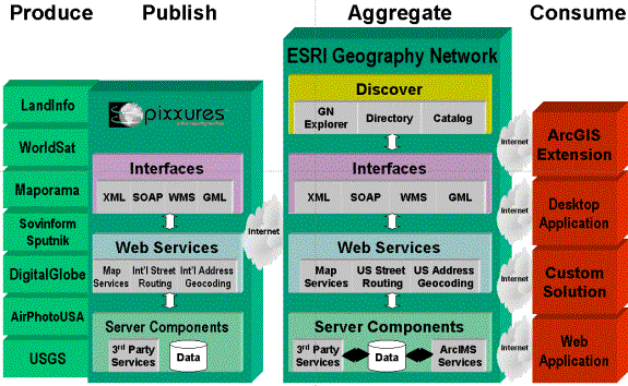
The Geography Network is a registry for web services, specifically relating to geographic information. It manages the registration of services, the aggregation of multiple services into a consistent environment. By utilizing a customized form of XML (ArcXML), services registered on the Geography Network each provides their specific type of information and services to the end user. Normally, companies providing data and services through the Geography Network do so with Esri’s ArcIMS, but the ArcXML specifications are published by Esri so that it is possible for companies to publish to the Geography Network by simulating an ArcIMS service. Pixxures is in the process of transitioning the WebPix web service to include IMS image publication to the Geography Network.
Technical Hurdles and Solutions
The WebPix Portal is a system of enterprise operations designed to provide simple access to Pixxures’ Data Pix image library. By eliminating all complex image management problems at the user side, the WebPix Portal provides ArcView users with immediate access to image data content on demand.
Imagery size Image data file sizes can be large, unwieldy and a non-trivial exercise to manage at the desktop. Individual image files can be upwards of several hundred megabytes in size, and several image files can be completely unmanageable. Several image compression technologies are emerging which enable users to effectively compress their own imagery for specific projects. On a large commercial scale, however, image file management is critical, image compression with minimal data loss is paramount and the speed at which the image is constructed is measured in milliseconds.
The size of a commercial seamless digital orthophoto library is staggering: In the province of Alberta alone (approximately 225,000 square miles), approximately 16 terabytes (trillion) of raw scanned color imagery for the entire province is converted through processing into 2.3 terabytes of orthophoto. With compression, approximately 153 gigabytes (billion) of data is stored on a direct access disk farm on the web server computer. For Pixxures’ USGS Digital Ortho Quarter Quad library, approximately 150,000 files of imagery comprising a total of 14 terabytes raw and 1.5 terabytes of compressed imagery are stored on disk. EarthWatch’s Millennium MosaicTM of 15m color continental US satellite imagery comprises approximately 200 GB of raw imagery and 13 GB of compressed data on disk. Air Photo USA’s 1m color coverage of 62% of the USA population consists of approximately 3 TB of uncompressed imagery and approximately 200 GB compressed.
Solution: In order to provide fast, multiple account access and instantaneous real-time retrieval of the data, an enterprise GIS system manages the locating and downloading. The extraction (and compilation if the request spans across two or more files) of a particular image is accomplished with decompression algorithms from Axion Spatial Imaging Ltd. that allow a user to create an image of any size of any ground resolution. For example, a single square kilometer of orthophoto extracted at the maximum 1m ground resolution contains 100,000 pixels, or approximately 1MB of 24-bit color data, uncompressed. If the user requires 5 meter ground resolution, an image of the same file size would cover 25 square kilometers. Normally, this process would take several hours to locate the multiple files, load, merge, crop, parse and geoposition the request. Leading-edge image library technology accomplishes this task in a fraction of a second - in real time. The appropriately sized and scaled image is created and downloaded and can be comprised of a high-resolution portion of one image or a seamless low-resolution composite of hundreds of images, depending on the required ground resolution.
The key to managing image size is to only create the download image to the size that the user requires at any given time. There is no need to download megabytes of image data if the user only requires an image on the screen. By creating the images at the users current map scale, time-consuming image downloads are eliminated and the user retrieves the imagery in real time.
Large Number of Image Files on Spinning Disk
The scale of an enterprise image hosting and delivery system is mind-boggling - the WebPix library currently has more than 300,000 image files on spinning disk - representing more than 30 terabytes of image data. This number is expected to double within the next 18 months.
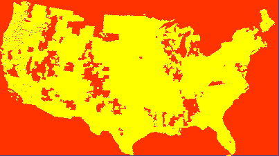
USGS DOQQ Program: 226,000 files - 21 TB, 90% continental US coverage
In order to provide immediate access to a specific file, each point in space must be referenced to the content on disk.
Solution: The WebPix Portal uses the Esri Spatial data Engine to record each image footprint’s position is space as well as the physical location of the file on disk. Speed of recovery of multiple files is measured in milliseconds, resulting in a real-time capability to locate, tile and project imagery.
Different users require different scales Users require imagery scales ranging from coarse resolution satellite with ground sampling at 15m or greater for regional analysis to sub-foot imagery for detailed analysis. Since there is no single image resolution which satisfies the requirements of all users, multiple resolutions of a variety of image sources must be stored for instantaneous delivery.
Solution: In order to provide complete flexibility for the user, a real-time process of image sampling was created as a part of the decompression process. When an image is requested at a particular scale, say 1.243 feet pixel size, the metadata controller determines which image data is appropriate, selects the appropriate files and samples the image at the requested ground resolution.
Speed of image composition In order for the imagery stored on disk to be useful to the end user, the image must be composed from the data on the server in real time.
Solution: To accomplish this, several steps are conducted, each taking a fraction of a second to process:
1. An application sends an http request to the image server for data from the Virtual Image-Server network. The Application passes required information to the Central Controller that determines the nature of the image to be returned.
2. The request is analyzed and the coordinates of the requested location are compared to the content of the Virtual Image-Server. A licensed software package SDE [1] is used to conduct the spatial search.
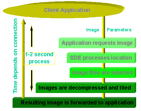
3. The specific image files determined from the search result are located on the Disk Storage and decompressed[2] as per instructions from the Central Controller.
4. The images required to fulfill the application’s order are tiled[3] and projected[4] to meet user’s requirements. These may include high resolution aerial images or satellite images.
5. The resulting whole image is returned back to the application and displayed / plotted for the user.
6. The total time from request to delivery is dependant on i) the number of files involved, ii) the speed of the CPU involved, iii) the size of the requested file(s) and iv) the bandwidth of the delivery service. On the Pixxures’ Image Hosting Facility, the entire panning or zooming process usually takes approximately 1 second to complete.
Map Projection and Datum / Spheroid Imagery is seldom orthorectified at the precise map projection and datum which the user requires. For example, some industries have adopted the NAD 83 spheroid whereas other industries, most notably the oil and gas industry, maintain all data in NAD 27. This discrepancy creates major cross-utilization problems and traditionally, two datasets would be required.
Solution: By creating a real-time datum and projection capability, image and vector data may be stored on the server in native format, eliminating the need to create a duplicate set of data. Image data can then be projected "on-the-fly" to the user’s required map projection.
Esri Desktop GIS integration In order to be useful on the desktop, the imagery must be seamlessly integrated into Esri’s desktop and web-based applications.
Solution: By enabling access to the central image library through the Geography Netwoek, Esri’s desktop applications can now utilize imagery in real time. ArcVIEW 3X utilizes a simple extension which automatically manages the retrieval of imagery from the portal. A real-time e-comm service provides a mechanism for the user to track usage of the imagery while at the same time providing the imagery providers with a mechanism of receiving royalty revenues.
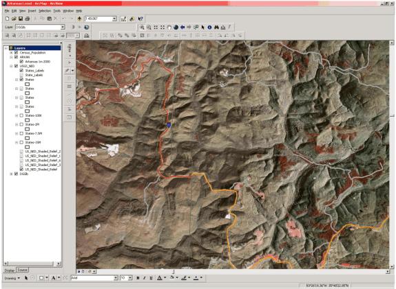
Integration of USGS CIR Imagery from the WebPix library, Esri’s Census data and USGS NED shaded relief data on the Geography Network.
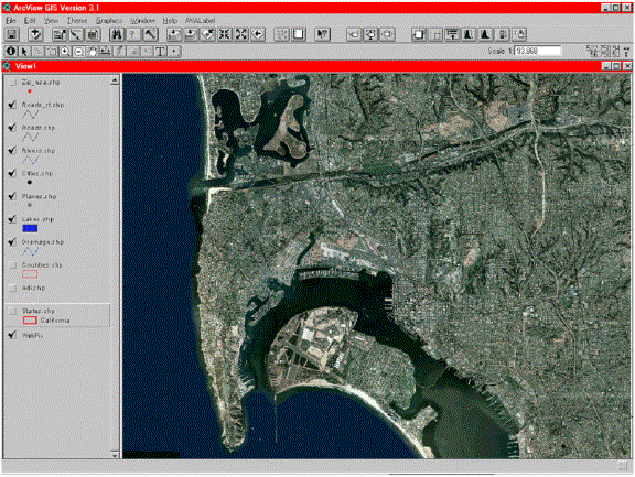
AirPhotoUSA’s 1m color imagery from the WebPix library using the ArcView 3.X extension.
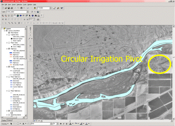
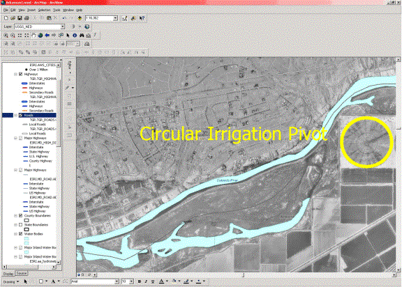
Unprojected USGS imagery in geographic coordinate space. Note elliptical irrigation pivot which in realty is circular.
UTM projection of same image - note circular pivot.
The Value of Imagery on the Geography Network
By incorporating imagery from the Geography Network directly into their applications, users of the WebPix library have observed these benefits:
- They do not have to deal with the collection, registration, indexing, storage and management of hundreds and thousands of gigabytes of image data.
- Image data is delivered in real time to their desktop application in the exact projection and datum required for the complete integration with their other mapping data.
- The data is maintained by Pixxures, allowing the company to focus on their core competencies of utilizing, rather than managing, the data.
- They realize significant cost benefits because the management of the imagery is shared amongst all participants.
- They have access to portions of a large data base which otherwise would either be unavailable to them or be cost-prohibitive to acquire.
Summary
The distribution of imagery on the Internet is now a viable and cost effective means of providing valuable reference information to the desktop through Esri’s Geography Network. Increases in the demand for on-line imagery from all business sectors has resulted in a viable business model involving image hosting, delivery, brokerage and desktop software integration. With the advent of faster connectivity, mature and less costly image hosting technology and viable web services registration methodlogies, Pixxures and Esri have joined forces through the Geography Network to meet this demand.
In developing an on-line image hosting and delivery facility, issues such as delivery speed, content currency and completeness, storage capacity and image retrieval speed, map projection and datum have to be considered. Pixxures, utilizing Esri technologies and the Geography Network, has developed a simple and cost-effective Internet-based capability and image hosting facility that effectively meets the requirements of this evolving market.
Contact Information and Author’s Biographies
Larry Herd (mailto:lherd@pixxures.com)
Prior to joining Pixxures, Larry was the president of Calgary, Alberta's largest geophysical consulting company, Boyd Exploration Consultants, Ltd. (BEC). After splitting off the geomatics division in 1998, Larry created Boyd Geomatics to commercialize BEC's proprietary image serving technology developed for oil and gas industry and municipal governments. After successfully raising venture capital for this commercialization, Larry positioned the company for expansion into other geographic markets, and in fourth quarter 2000, facilitated the sale of Boyd Geomatics, Ltd. to Pixxures, Inc.
Larry has an MBA from University of Calgary and is a professional geophysicist. He is responsible for the implementation of Pixxures' Internet strategy as well as the ongoing Pixxures Internet Business Unit activities.
Larry Herd
Vice President, Internet Business
Pixxures, Inc. http://www.pixxures.com/
15000 W64th Avenue, Arvada, CO 80007
(303) 302-8600
[1] Spatial Data Engine (SDE) by Esri is an enterprise scale spatial search engine that rapidly searches a spatial database.
[2] The image data is decompressed using licensed decompression software from Axion Spatial Imaging, Edmonton, Alberta, Canada.
[3] Tiling images involves putting each image in the appropriate spatial location and combining to make a whole, seamless image.
[4] Each image must be placed in the appropriate map projection to be suitable for use.