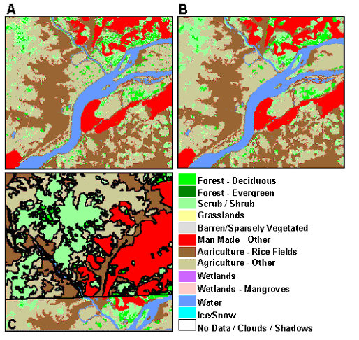
Figure 1. An example of GeoCover LC Products
Earth Satellite Corporation (EarthSat) has developed two products based on Landsat data. GeoCover Ortho is a database of orthorectified Landsat TM scenes for the land masses of the world. This data is available from NASA, USGS, and EarthSat. GeoCover LC is a global landcover database derived from GeoCover Ortho imagery. This data consists of 13 landcover classes and is currently available for North America, Africa, the Middle East and Southwest Asia, and East Asia. This paper briefly describes the status of the project and the process used to create this data set
Moderate resolution, resource-focused satellite remote sensing has been available since the launch of ERTS1, (later renamed Landsat 1) on July 23, 1972. Today, 30 years after the launch of the first Landsat satellite, the Landsat program continues to provide global moderate resolution, multispectral imagery. Imagery from the Landsat program has been, and continues to be used for a variety of applications in fields ranging from archeology to zoology. In fact "The data from the Landsat spacecraft constitute the longest record of the Earth's continental surfaces as seen from space. It is a record unmatched in quality, detail, coverage, and value." (NASA)
In 1997 Earth Satellite Corporation (EarthSat) proposed to NASA's Earth Science Enterprise to tap into this vast archive and develop a consistent, geodetically accurate, moderate resolution image base for the Earth. The goal was to develop a global orthorectified image base and global landcover database that would help enable the exploitation of this incredible but largely untapped resource. In 1998 with funding from NASA and NIMA, EarthSat began to develop the GeoCover Ortho and GeoCover LC products.
The GeoCover Ortho product is based on circa 1990 (generally +/- 3 years) Landsat TM data that has been orthorectified to less than a 50 meter RMS error. This image base is then used to coregister late 1970's Landsat MSS data and circa 2000 Landsat ETM+ data. Once this project is completed there will be a consistently orthorectified image base from the 1970's, 1990's and 2000 (Landsat MSS, TM, and ETM+) available for all the land areas covered by the Landsat program. These data are available with no copyright restriction and can be obtained from the Land Processes Distributed Active Archive Center at EROS Data Center at http://edcimswww.cr.usgs.gov/pub/imswelcome/ EarthSat is also creating 6 degree wide by 5 degree tall (UTM zone) MrSID compressed mosaics of the imagery (bands 7, 4, 2). These mosaics can be downloaded from NASA at http://zulu.ssc.nasa.gov/mrsid/
The availability of a global orthorectified, geodetically accurate Landsat image base provides scientists, educators, and the public the most accurate, global, comprehensive, up-to-date data available. The GeoCover LC program extends the use of the imagery by extracting land cover information from this imagery. The landcover categories in the GeoCover LC product follow closely to those defined by Anderson et al. in his 1976 publication, "A Land Use and Land Cover Classification System for Use With Remote Sensor Data" (U.S.G.S. Professional Paper 964). Brief descriptions of the 13-landcover categories are shown below in Table 1.
|
|||||||||||||||||||||||||||||||||||||||||||||
The goal of the GeoCover LC program is to provide a fairly basic landcover classification but prepare it in a way that is accurate, consistent, and global. Extracting this information from moderate resolution Landsat imagery is a enormous task; over 7,600 scenes must be processed. In order to process this much imagery consistently, accurately, and efficiently EarthSat focused on three important aspects. First, automate as much of the process as possible; second, rely on time-tested image processing and analyst-driven interpretation to extract the land cover information; and third, implement continual quality control and process improvement to produce the highest quality product within stringent time and budget constraints
EarthSat's land cover extraction process relies heavily on commercial software (ERDAS IMAGINE, and Esri Arc/INFO) that has been customized by EarthSat personnel to improve production efficiency. The following is a brief description of EarthSat's procedure.
Unsupervised classification techniques are used to produce a thematic image with 240 spectral clusters. EarthSat uses IMAGINE's ISODATA clustering algorithm to generate the spectral signatures. These signatures are then run through a maximum likelihood classifier to produce a thematic image.
Skilled image analysts work in geographically focused teams to group and edit 240 spectral classes into 13 landcover categories (shown in Table 1.) It is critical that all image analysts work in a team environment, communicating as they research ground truth databases, visualizing and discussing imagery, consulting with senior remote sensing scientists, and working together to analyze spectral and spatial relationships necessary to extract land cover from imagery. Synthesizing a variety of disparate and oftentimes conflicting sources (including existing land cover, ground truth, information from adjacent scenes, and any other source of ancillary data) and incorporating both spectral and spatial relationship found in the imagery is the strength of a trained image analyst and the key component in GeoCover LC processing.
Once an analyst has completed preliminary grouping and editing the scene is submitted to an independent quality control team for review. The QC team reviews each scene for individual class accuracy as well as consistency of interpretation between image analysts. After a scene has passed the individual scene QC inspection (often after multiple iterations) the scene is approved for further processing.
A landcover image mosaic is then created, integrating multiple Landsat scenes within a geographic area - typically all scenes within a UTM zone. This mosaic has a formal QC process to ensure consistency in areas of scene overlap as well as throughout the entire region. The landcover mosaic is then used to clip out individual scene as well as one degree by one degree cell products. Table 2 briefly describes the GeoCover LC final products that are available.
|
|||||||||||||||||||||||||||||||||||
Figure 1. An example of GeoCover LC Products
The landcover product has been independently validated and has averaged over 72% accuracy throughout the world.
In less than three years EarthSat has completed over 4,000 GeoCover LC scenes and over 12,000 one degree by one degree water masks. (See figures 2, 3, and 4 for data availability.) This is the most extensive landcover-mapping program conducted using Landsat data.
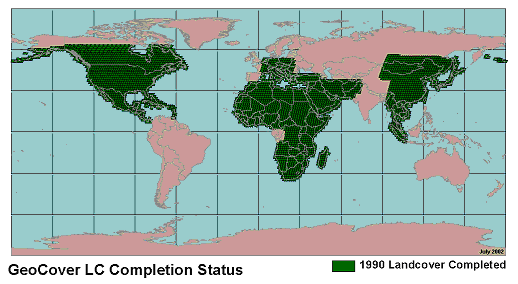
Figure 2. GeoCover LC circa 1990 land cover availability
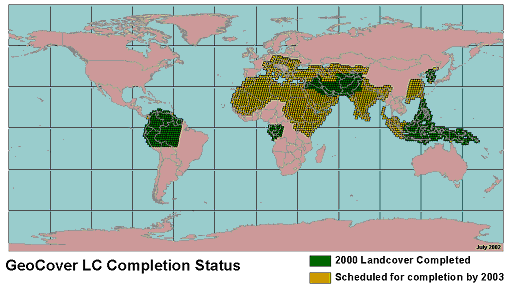
Figure 3. GeoCover LC circa 2000 land cover availability
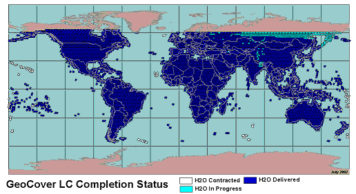
Figure 4. GeoCover LC water mask availability
Anderson, J. R., Hardy, E. E., Roach, J. T. and Witmer, R. E., 1976. "A Land Use and Land Cover Classification System for Use with Remote Sensor Data." U.S. Geological Survey, Professional Paper 964. Reston, VA.
Dykstra, Jon. "The GeoCover Ortho Program." GeoInformatics. Volume 4. January/February 2001. Emmeloord, The Netherlands. . p 26-29. http://www.geoinformatics.com/issueonline/issues/2001/01_02_2001/pdf_01_02_2001/p26_29_dijkstra.pdf
NASA. "NASA Celebrates the 25th Anniversary of Landsat, Remarks for the Congressional Record." http://geo.arc.nasa.gov/sge/landsat/lsat25b.html
David J. Cunningham,
Vice President, Environmental and GIS Services
email: dcunningham@earthsat.com
Jeannine E. Melican
Program Director, GeoCover LC
email: jmelican@earthsat.com
Eric Wemmelmann
Production Manager
email: ewemmelmann@earthsat.com
Thomas B. Jones
Former Program Director
email: tjones@earthsat.com
Earth Satellite Corporation (EarthSat)
6011 Executive Blvd. Suite 400
Rockville MD USA 20852-2804
Telephone: (301) 231-0660
FAX: (301) 231-5020
http://www.earthsat.com
http://www.geocover.com