Managing the Storm
Stormwater Pollution Management
California Department of Transportation
Storm Drain System Inventory
Douglas C. Brice, Senior GIS Analyst, Burns & McDonnell, San Francisco, California
Danielle Starring, Assistant Environmental Engineer, Burns & McDonnell, San Francisco, California
Twenty-five years ago, only a third of the nation’s waters
were safe for fishing and swimming. Wetland losses were estimated to be 460,000
acres annually. Agricultural runoff resulted in the erosion of 2.25 billion
tons of soil and the deposition of large amounts of phosphorus and nitrogen
into many waters.
In response to growing public concern for this serious and
widespread water pollution, in 1972 Congress enacted the Clean Water Act (CWA),
the first comprehensive national clean water legislation. The CWA is the primary
federal law that protects our nation’s waters, including lakes, rivers, aquifers
and coastal areas.
A result of the Clean Water Act was the creation of the National
Pollutant Discharge Elimination System (NPDES) permit program. The NPDES program
was created to control water pollution by regulating point sources that discharge
pollutants into surface waters of the United States. A point source generally
refers to a conveyance such as a pipe or man-made ditch. In California, the
EPA has delegated the administration of the NPDES program to the State Water
Resources Control Board (SWRCB) and the nine Regional Water Quality Control
Broads (RWQCBs). Since its introduction in 1972, the NPDES permit program has
been responsible for significant improvements to our nation’s water quality.
 |
The NPDES permitting system is of particular
importance to the California Department of Transportation (Caltrans). Under
these federal regulations, many Caltrans properties and facilities fall
under the jurisdiction of the NPDES permitting system. Every time it rains,
water washes materials from highways, streets, and gutters into the storm
drain system. Highways typically contain vehicle exhaust products, brake
and tire materials, oil and grease, litter and other materials that get
flushed through the storm drain system and eventually into our rivers, lakes,
and the ocean. With Caltrans maintaining approximately 15,000 miles of highway,
12,000 bridges and more than 230,000 acres of right-of-way, the potential
for a serious pollution problem is great. |
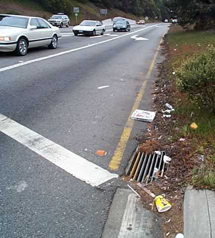
| Trash strewn storm
drain inlet. |
|
To address this issue, Caltrans has developed a Storm Water Management Plan (SWMP).
The SWMP serves as a framework for meeting NPDES permit requirements for Caltrans
stormwater discharge and guides all Caltrans activities related to stormwater
control and treatment. As part of the SWMP, Caltrans has initiated a Storm Drain
System Inventory (SDSI). The SDSI documents all stormwater features along the
Caltrans right-of-way. In addition to the highway right-of-way, the project includes
inventorying highway-related facilities, including maintenance stations, park-and-ride
lots, rest areas, vista points, toll plazas and inspection stations. The completed
inventory will give Caltrans engineers a clear vision of existing storm water
features and allow them to identify sites where pollution prevention devices could
be employed.
Project Overview
|
In order to accomplish this challenging
task, Caltrans has enlisted the help of Burns & McDonnell to perform
the inventory in both District 4 (San Francisco Bay Area) and District
12 (Orange County). Stormwater inlets, outfalls, discharge points, drainage
areas, and facilities were inventoried using a combination of sub-meter
GPS units, pen-based computers, laser range finders, and digital cameras.
Under the first phase of the NPDES
stormwater permit, Caltrans was required to conduct the inventory in areas
where the population surrounding the highway within a one-mile radius
exceeded 100,000 people, as directed by the 1996 U.S. Census. These areas
were classified as having municipal separate stormwater sewer systems
(MS4) and considered to have the highest risk for violating the NPDES
permit. Based upon this selection criteria, the SDSI encompassed 900 highway
miles in the San Francisco Bay Area as well as 310 miles in Orange County
(Southern California).
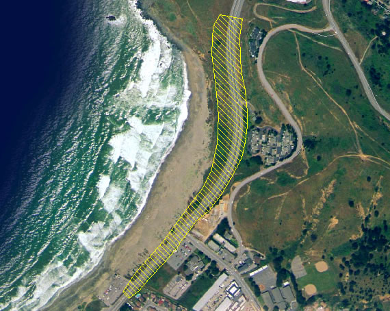
|
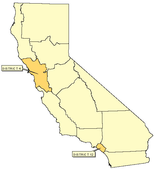 |
| |
Map of project study area.
|
Features Inventoried
The SDSI project involved Burns & McDonnell inventorying
all stormwater features found within the Caltrans right-of-way; these included
inlets, outfalls, discharge points, tributary drainage areas (TDAs) and facilities.
Inlets
 |
Inlets are typically defined as structures
that convey stormwater from the surface into a drainage system to an outfall
and/or discharge point. Since the inlet serves as the point of entry into
the system, it is important to know how it is being impacted by the surroundings.
An inlet can be flush to the surface, adjoined to a curb, elevated above
grade or open culvert pipe. The type of surface the stormwater is draining
from as well as what kinds of grates are being used will let Caltrans know
where potential sources for contaminant entry may occur. |
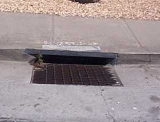
| Example of storm
drain inlet. |
|
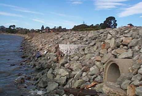
Outfalls
|
Outfalls are typically defined as the end point of
a pipe that daylights within the Caltrans right-of-way and then releases
to a discharge point. There are several different types of pipe material
that Caltrans uses including asphalt, corrugated metal, reinforced concrete,
vitrified clay, and various plastic grades. Field crews inventory the
type, size, and surrounding surface information to better characterize
where stormwater is being channeled within the right-of-way. Additional
information regarding the presence of dry flow, local vegetation, and
accessibility will enable Caltrans to determine where best management
practices (BMPs) should be implemented, if they do not already exist.
|
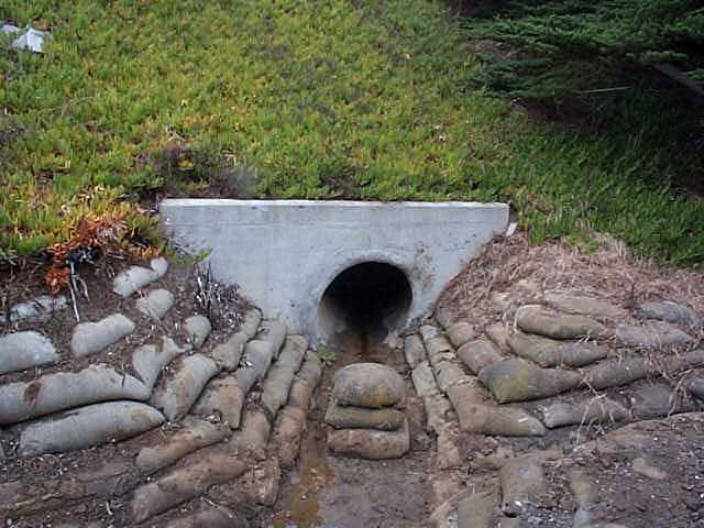 |
| |
Example of storm
drain outfall. |
Discharge Points
 |
Discharge points are usually the end point
of a pipe, culvert, channel, swale, or ditch that discharges from the right-of-way
into a stormwater conveyance system, manholes, junction boxes or inlet that
connects downstream to a storm sewer system. Since the stormwater leaving
the right-of-way is Caltrans' responsibility under the NPDES permit, field
crews collected as much information as possible about the point and surrounding
area. Similar to outfalls, pipe type, size, site vegetation, site accessibility,
visibility from the highway, and the presence of a best management practice
information was inventoried. In addition to this, field crews collected
data regarding where the stormwater is discharging to and if any illegal
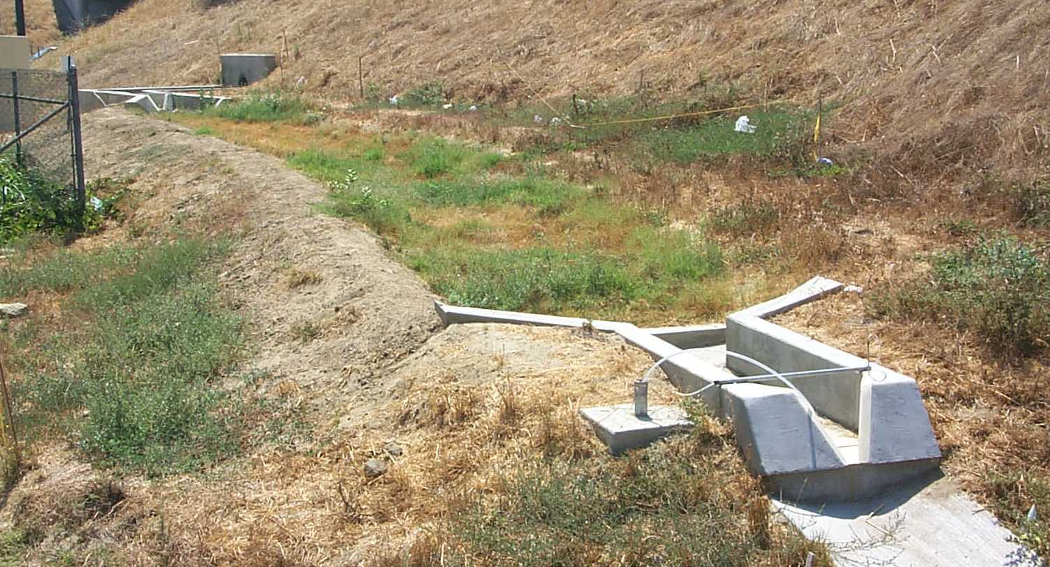
discharges were found in the area. |
|
Example of storm drain system discharge
point.
|
|
In many cases discharge points were classified as MS4.
An MS4 is a storm sewer that is owned and operated by the local municipal entity.
With an MS4 connection, Caltrans is discharging their stormwater into the municipal
system for conveyance to a receiving water body or treatment facility. Since
the inventory was conducted mainly in these urbanized areas, many discharge
points were classified simply as MS4 connections. In these cases field crews
concluded that discharge points were underground piping leaving the right-of-way.
This could be verified by the use of as-built drawings or by observing the piping
directions in the discharging inlets.
TDA
|
A tributary drainage area (TDA) is typically considered
the area that drains stormwater directly to the referenced structures.
It is an area that is defined both by a legal boundary, the right-of-way,
and a hydraulic boundary, which is some feature of the terrain that guides
the flow of water. Once the inlets, outfalls, and a likely discharge point
were collected, field crews were able to determine the extent of the drainage
area. TDAs were drawn in PenMap based on field observations and as-built
information where available. When delineating a boundary line, it was
important to be aware of the surrounding slope of the land, the surface
grade, and the characteristics concerning the discharge point.
|
 |
| |
Example of TDA.
|
The right-of-way runs along the entire length of the highway,
and was the primary factor when considering a TDA boundary. As the crews advanced
along the right-of-way, they were cognizant of where TDA boundaries were linked
to specific discharge points. Beginning from the discharge point, field crews
traced back to all the inlets and outfalls that direct water to that point.
The limit of the area that feeds into these structures forms the hydraulic boundaries
of the TDA. TDAs were assumed to be polygons, and extended out to the right-of-way
line on both sides of the highway. In most cases TDAs were linked to each other.
The only exception to this was where the highway had no drainage conveyance
system in place and no evidence of stormwater leaving the right-of-way, an occurrence
known as sheet flow.
Field crews collected data about the land encompassed in
the drainage area, including surface type, approximate average slope, and percentage
that is pervious or exposed to infiltration of stormwater. Crews also looked
for the presence of pump stations, as this indicates that stormwater is being
channeled to specific places for treatment or discharge into a receiving waterbody.
Facilities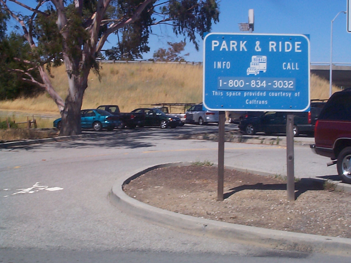
Under the NPDES stormwater permit, Caltrans
was also responsible for the drainage in the facilities they operate and/or
maintain. These areas are mainly comprised of maintenance stations, park &
rides, weigh stations, vista points, and rest areas. There are hundreds of these
facilities that are located along the highways, as well as neighboring cities.
In an effort to control drainage, facilities can have inlets, outfalls, and
discharge points. Field crews were required to collect all of these point features,
delineate appropriate TDAs, and collect the perimeter of the facility. Field
collected information was very similar to a TDA, including surface type and
percentage of land that is pervious to stormwater. These facilities could have
discharge points that were associated with the highway, but in most cases were
self-contained or connected directly into the local municipal system.
Equipment Overview
Burns & McDonnell had to carefully develop a strategy to
perform the data collection. Due to the complex nature of the data being collected,
a computer system was needed that was portable, could be used in the field,
and had the power and ability to integrate various pieces of equipment.
 |
After reviewing several options, PenMap software running
on Via field computers was chosen. PenMap is a real-time surveying, mapping,
navigation and GIS data collection software that allows the user to view
and edit maps and related data while in the field. PenMap gave Burns &
McDonnell the ability to integrate all the data collection instruments,
including laser range finders, GPS receivers, and digital cameras. Storm
drain features were inventoried using a combination of Global Positioning
System (GPS), pen-based field computer, laser range finder and digital
cameras. The field computer combines a wearable PC with customizable software
to provide field crews the full-function power of a laptop. PenMap allows
the user to integrate the many types of data collection tools, and organize
them into one information system.
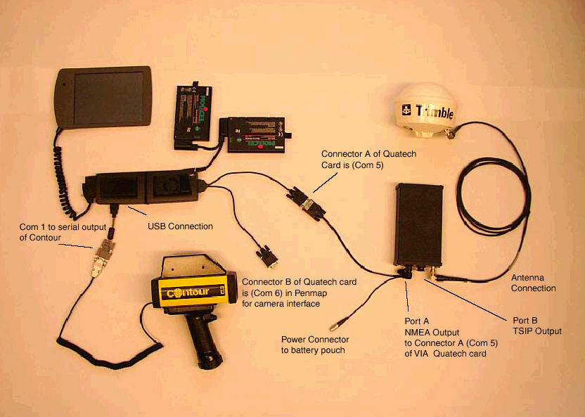
|
| System components
used in field inventory. |
|
|
The GPS receiver unit provides real-time
sub-meter accuracy, with GPS, WAAS, satellite differential, and beacon capabilities.The
integration and flexibility of these technologiesmeans that there is less
equipment to carry. The system provides two-way data flow between the field
and GIS, facilitating the data collection and data maintenance processes.
By taking advantage of these real-time features, the need for post-processing
GPS data is removed, which further closes the gap between fieldwork and
GIS. Digital cameras were used for the collection of field photographs.
These photographs were then directly linked to the feature information being
collected. A laser range finder (LRF) was used for distance measurement,
as well as other surveying and mapping uses. The Class 1 eye safe LRF, with
an integrated digital compass and inclinometer, accurately reported the
distance, bearing and inclination to the selected feature. In previous inventory
activities, these devices were cumbersome and very not transportable. This
setup allowed for the integration of all the data collection tools into
one portable field system. |
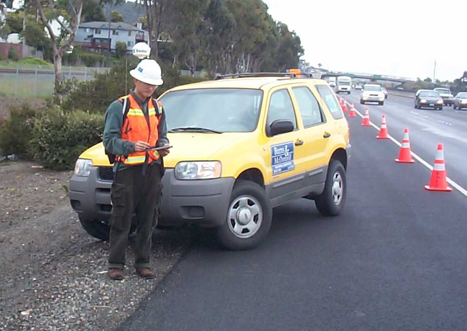 |
| |
Field
crew member performing inventory. |
Field Collection Process
 |
The advantage of using integrated system components
is the ability to perform the field inventory within a single software
environment. The PenMap software allows for the collection of real-time
GPS data then permits the user through a series of customized forms to
add additional attributes from a list of values. Taking advantage of the
use of forms with pre-defined value selections builds data consistency
and standardization.
The software’s flexible and highly customizable interface
and forms allowed for the creation of specialized features and attribute
forms needed for the stormwater inventory. The PenMap software’s import
utility allowed for both raster and vector data to be imported and displayed,
while the export utility permitted field collected data to be saved and
exported directly into Esri Shapefile format.
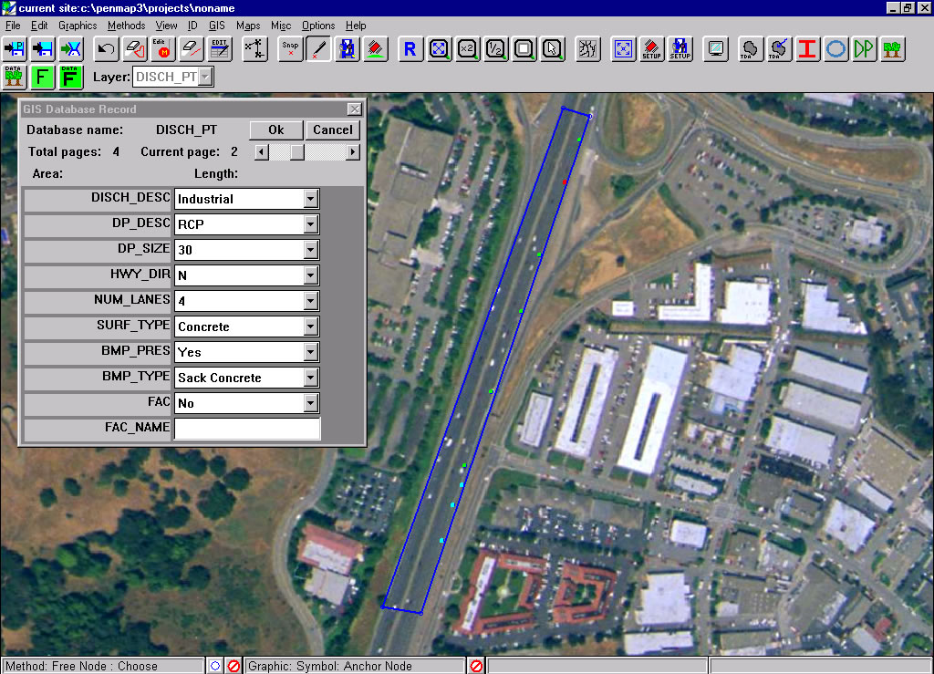
|
|
Discharge point inventory form within
PenMap software.
|
|
GIS Processes
|
As the data was being collected in
the field, it was periodically exported from PenMap into Esri shapefile
format. From there it was fed into a comprehensive GIS-based quality assurance
program. The customized program, which ran in Esri’s ArcView 3.2, assigned
unique IDs to each collected feature and performed various data validation
checks. The program analyzed the data on the individual TDA basis and
treated the features within that TDA as a storm drain system within itself
(inlets drain to outfalls, outfalls drain to discharge point, TDA encompasses
the entire area).
After running through the QC process,
data was organized and merged by highway number and feature type. As the
inventory for each county within the Caltrans districts was completed,
each feature was attributed with a series of overlays to provide additional
fields of information (city, county, hydrologic unit/sub unit, soil type,
etc.).
|
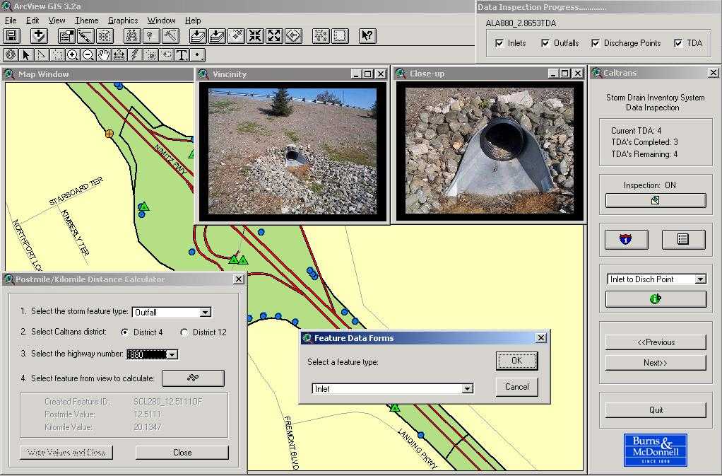 |
| |
Example of GIS-based
QC program running in ArcView 3.2. |
Pollution Prevention
 |
The SDSI gives Caltrans a powerful tool
in stormwater management. The completed project will allow Caltrans engineers
to visualize the data not so much as individual features but instead see
each TDA as a stormwater system itself. The inventory tracks the flow of
water from where it enters a storm drain inlet to the receiving water body.
The data will help Caltrans review existing storm features for adequacy
and system maintenance as well as serve as a helpful tool for planning highway
construction. The delineated TDAs will allow engineers to assign runoff
coefficients and compute volume calculations, while the discharge points
will show where stormwater leaves the Caltrans right-of-way. |
|
|
Example of Bio Swale Best Management
Practice.
|
|
Once the question of ‘where’ has been answered, the task of
pollution prevention can be addressed. As part of SWMP, Caltrans is currently
attempting to identify discharge points and outfalls along the highways where
BMPs can be utilized. A BMP is a technique, measure or structure used to control
the quantity and improve the quality of storm water runoff. Specially designed
filtration devices, retention ponds, and bioretention areas are all examples
of BMPs that serve to reduce the amount of contaminants leaving the Caltrans
right-of-way and entering our waterways. The continued utilization of BMP technology
is an important component of Caltrans’ comprehensive effort to preserve and
improve water quality in California.
Summary
Since the Clean Water Act was enacted in 1972, the quality
of America’s waters has steadily improved. The cooperative effort of federal,
state, and local governments to implement pollution control programs has gone
a long way towards preserving healthy water quality. Stormwater system inventories,
such as the one described, that harness the power and flexibility of today’s
spatial and information technologies provide a powerful tool in the management
and treatment of stormwater runoff and the pollutants it carries.
References
Storm Water Management Program.2001. Storm Water Management Plan. California
Department of Transportation. Sacramento, CA.
Office of Wastewater Management.2002. Water Permitting 101. Office of
Water. United States Environmental Protection Agency. Washington D.C.
Environmental Program.2002.Storm Drain System Inventory User’s Manual.
California Department of Transportation, Sacramento, CA.