Can local storm reports be forecast by early knowledge of NEXRAD-identified storm attributes? We explore this hypothesis through GIS spatial analysis using local storm reports (LSR) published by the National Weather Service and severe storm locations identified by NEXRAD weather radar. These data are analyzed for spatial correlations among storm attributes categorized by tornadic or mesocyclone signature, hail size and probability, echo intensity, and LSR damage type and severity.
After a severe storm rolls through an area, reports of local damage are compiled by the National Weather Service (NWS) into a text report, commonly referred to as the "Local Storm Report". Various official and civil authorities, including police, local media, storm spotters, and the general public, provide information on the damage location, time, and type. The Local Storm Report is officially released to the public around 24 hours after a storm.
What if one could predict the location and severity of a Local Storm Report well before the official release, perhaps even in near real time? Could the emergency responders be able to more effectively deploy the right amount of resources to the areas needing help most? Would an insurance company be able to better secure the highest quality adjusters to manage potential claims?
We explore the possibility of predicting a Local Storm Report by using data from the combined attribute tables of the NEXRAD Doppler weather radar network. The combined attribute table contains a many quantitative measures of storm properties related to direction, speed, and intensity. This is the same information that television weather forecasters use to predict when severe storms will likely move through a community.
Local Storm Report text files are routinely decoded by the Meteorlogix data center and stored in a database table system. The fields in the LSR database table include observed date and time, latitude, longitude, text description of the event, maximum wind gust, maximum hail size, and tornado class on the Fujitso scale.
The Combined Attribute Table contains output from several algorithms or computer programs that run ever time the radar initiates a volume scan (approximately every five minutes). The output from these algorithms can give valuable information about storm position, strength, severity as well as other critical elements. The ability to look inside of storm and detect small scale rotation and other severe indications can give users of radar data valuable lead time which can be used for storm avoidance or preparation.
Mesocyclones are areas of strong localized cyclonic rotating winds found in severe supercell thunderstorms. It is important to note that there is a much stronger relationship between Mesocyclones and large hail than there is between Mesocyclones and tornadoes. There are actually 3 types of Mesocyclone formations possible: Mesocyclone, 2D and 3D Shear. Starting with 2D, the complete term is 2D Uncorrelated Shear, which means the rotation was only found at one level and is not continuous up or down in the storm. 3D, which is actually 3D Correlated Shear, indicates that rotation was found at multiple elevation angles in the storm, however those features DO NOT meet the size and symmetry criteria for a mesocyclone, and finally Mesocyclone itself, which is the most severe of the 3 entries, indicating rotation was detected at multiple levels in the storm and the stringent wind and wind shear criteria were met.
A TVS is a signature, or indication, of a potential tornado. It is basically an indication of strong wind shear (or changing wind direction) in a very small area associated with potential tornadic circulation within a thunderstorm. An Elevated TVS meets the stringent criteria for a TVS, plus adds in more vertical restrictions, which makes the storm much more likely to produce a tornado. A TVS is no guarantee a tornado will form, but definitely a strong indication that one may soon develop, or already has.
In preparation for spatial analysis, data from the Local Storm Reports and NEXRAD Attribute Tables were needed in a GIS compatible format. LSR database tables were directly converted to point feature tables in a geodatabase using ArcCatalog 8.1 (Esri).
NEXRAD Attribute Tables were obtained from the Meteorlogix data stream and operationally converted to point shapefiles upon receipt by a MxInsight Metwork GIS workstation from Meteorlogix. This data was then passed to an ArcView GIS (Esri) application which read the forecast direction and speed of each storm and created a polygon shapefile of the storm path for the next 10 minutes. These storm corridor polygon shapefiles were archived for subsequent analysis. Storm corridor archives were available for eleven dates: 03/25/2002 to 03/28/2002, 04/10/2002, 04/17/2002 to 04/19/2002, and 04/25/2002 to 04/26/2002.
ArcMap 8.1 software (Esri) was used to bring both LSR and storm corridor data sets into the same map view for spatial analysis. First, LSR data were restricted (query by attributes) to the time period for which storm corridor data was archived. Next, all polygon storm corridors were merged into a single geodatabase. The storm corridors were queried according to the spatial location of the LSR locations and constrained to within 24 hours of the observed storm report.
Statistics were calculated for storms corridors coincident with a Local Storm Report. Correlation statistics between storm corridor attributes and local storm report fields for wind, hail, and tornado class were also calculated.
Out of 95,060 storm corridors recorded on the eleven archived days, only 2956 were co-located over local storm reports. Storm attributes for storms over local storm reports were significantly more intense, however, than those not associated with local storm reports. Storm speed, maximum dBZ (logarithmic measure of radar intensity), and vertically integrated liquid measurements were all greater for storms associated with a local storm report (Fig. 1).
Figure 1.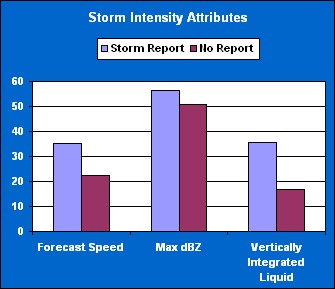
Likewise, NEXRAD-identified storm corridors associated with local storm reports were higher, indicating greater storm development (Fig. 2).
Figure 2.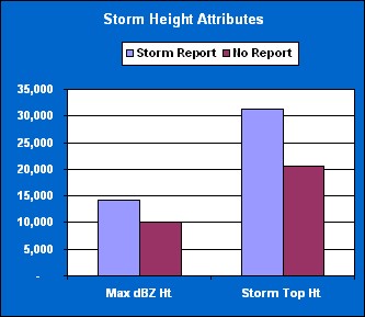
Eighty percent of the local storm report records were of hail damage. The NEXRAD attribute parameters for probability of any hail and severe hail (over 0.75 inch diameter) were also significantly greater for storms over local storm report locations (Fig. 3).
Figure 3.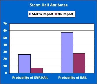
Correlation statistics for NEXRAD storm attributes for storms over local storm reports were calculated. Correlations were low among all the local storm report measurements. Therefore, the NEXRAD storm attributes were not good predictors of the local storm report measurement of intensity. Upon further investigation into the local storm reports, many of the quantitative measurements of wind gusts and hail appeared to be based upon subjective observations. Many of the hail size values came from anecdotal descriptions of "dime-size" or "nickel-size" hail. A more promising method of quantitative analysis of the local storm reports may be through categorical characterization.