Title: Wireless Planning in Lincoln, Nebraska
Author: Abigail P. Davis
Abstract:
The Wireless Planning GIS Project in Lincoln, Nebraska, is a useful tool for city planners and government officials involved with telecommunications technology planning, specifically personal wireless facilities. A spatial database of approved city and county special permits for communication and wireless facilities in the City of Lincoln and Lancaster County, Nebraska provides both image and textual data. This project addresses current concerns and issues involved with planning and the telecommunications industry, and can be used by city and county planners, government officials, private citizens, and interested telecommunications companies.
GIS in the Planning of Personal Wireless Facilities in Lincoln, Nebraska
Introduction.
This paper will discuss the Personal Wireless Facilities GIS Project of the Lincoln/Lancaster County Planning Department in Lincoln, Nebraska. This project is a useful tool for city planners, government officials, and private citizens involved with personal wireless facility planning. In addition, there are research applications for interested telecommunications companies.
The zoning ordinances of both the City of Lincoln and Lancaster County concerning personal wireless facilities require telecommunication companies to obtain a special permit before receiving a building permit. ArcView GIS by Esri supplied a unique opportunity for planners to be able to see the geographic location of special permits for wireless facilities throughout the city and county, while also being able to access tabular data concerning these permits.
A spatial database is used in this project of approved city and county special permits for communication and wireless facilities in the City of Lincoln and Lancaster County, Nebraska. The database provides planners with updated information of personal wireless facility sites such as owner of facility, type of facility (monopole, lattice, stealth facilities, collocations), applicant name, height of facility, address, use (PCS, cellular, ESMR), zoning district, year approved, Administrative Special Permit Number, Special Permit Number, Resolution Number, and Executive Order Number. In addition, photographs of a number of facilities and facility design are also included.
The potential applications of this tool are numerous, and the previous list is only a beginning of possibilities. This paper will discuss some of these potential uses, as well as related issues and concerns when working with personal wireless facilities from a land use planner's perspective. This project is intended to be used in a variety of ways by other planning departments, planning commissions and other governmental officials; private citizens; and telecommunications companies in similar situations, eager to hear about the challenges faced by one planning department when involved with the fast-paced, rapidly changing telecommunications industry and personal wireless facility planning.
Background.
There are many issues that must be addressed by planners when involved with the permit process and approval associated with personal wireless facilities. Unlike most processes that land use planners play a role in, wireless facilities bring in a twist that adds difficulty- that of new technology. It is difficult because new technology is often alarming to the general public. As with any new technology, especially those dealing with radio or micro waves, the general public is simultaneously delighted with the convenience of it, yet often concerned with their health, safety, and welfare. A few major concerns are safety, aesthetics, and the issue of local jurisdiction in regulating and monitoring telecommunications companies activities and the personal wireless facilities that are necessary for operation. Perhaps the reader has witnessed private citizens and city officials in public hearings say that they were afraid of airplanes or helicopters crashing into a celltower which would then fall on their home, that they are concerned that the radio waves emit dangerously high radiation, killing children and trees, that a celltower will be an eyesore in the neighborhood if approved, and will affect their quality of life and the value of their real estate, or why can we not, as a city, deny an application if we wanted to?
Similar fears surfaced with the advent of the telephone, television, or microwave. One distinct difference is that unlike the telephone, which had a very controlled market growth characteristic of a monopoly, the telecommunications industry had and continues to have a more open market, resulting in a high level of competition and rapid growth.(1) A positive economic phenomenon of this rapid growth is the interplay between an increase of competitors, resulting in an increase of supply and consumer demand. As the price of cellphones and associated services are driven down, the general public sees wireless technology as a feasible option. In fact, "the past two years have seen cellular subscribers soar by more than 40 percent, to 123 million."
Telecommunications companies have been well aware of the unique economic
opportunities their industry is creating. It is the public sector that is now raising their head to see
the importance of their own involvement and technological education, in order to fulfill their role
of representing the best interest of the people. At the same time, cities are exploring ways to
utilize the industry for local economic development. The City of Lincoln, for example, has
created a "Mayor's Technology Council" for which one focus is on "technology in economic
development efforts and increased telecommunication opportunities and competition."(2)
Yet disseminating information on technology takes time, and the time period that the general public sees one, four, then suddenly twenty celltowers erected in their city is very short. Inevitably, panic strikes the neighborhoods and public hearings are wrought with controversy. There is little time for the public to be educated on telecommunication technology before the public hearing has come and gone, the permits have been approved and the facility is up and running . The general public, the planner, the city officials, and the wireless company all end up frustrated, unsatisfied, and exhausted. Meanwhile, the wireless company completes their buildout, there is a lull in activity, until a new company comes to town, and the process begins again.
A multitude of concerns such as local and federal legislation, zoning, city department policy, and technology are voiced by private citizens and governmental officials and are important, whether real or perceived, and need to be addressed by the city planner. In order to do so, however, the planner must be informed. As a land use planner, however, it is generally the technology that is the most unfamiliar aspect of the whole list. Therefore, the planner may have many of the same questions and concerns as the ones she hears in a public hearing.
It is the planner's responsibility to educate herself and, to various degrees, also educate private citizens, planning commissioners, and city council members on wireless technology and the legislation that regulates it. A sure step forward is a spatial database providing a view of all approved facilities throughout the city and county, and data on each of those facilities all included in one GIS project, accessible and organized. Clearly defining specific aspects and relationships is always a good step in understanding a complicated, unfamiliar environment.
Sources and Methodology.
The sources used for this project range from collected data by a previous planner to recent photos taken of existing personal wireless facilities. An enormous amount of time was given by Natalie Becker, a short term land use intern in the planning department. In addition, staff in the Information and Planning Division within the planning department provided invaluable ideas and advice on how to make the project a success. See the table below for specific sources used and who or where the source was found.
| Source | Repository |
| Knowledge, experience and advice on personal wireless facilities in Lincoln/Lancaster County | previous land use planner |
| spreadsheet of personal wireless facilities | previous land use planner |
| GIS project of city/county personal wireless facilities | previous land use planner |
| ARC/INFO coverage of personal wireless facilities | Information and Planning Division of the Planning Department |
| Knowledge, experience and advice on personal wireless facility cover design | Information and Planning Division of the Planning Department |
| Title 27, Lincoln Municipal Code, Chapter 27.68, Personal Wireless Facilities Zoning Ordinance 17588 section 1, January 18, 2000. | Planning Department |
| City Policy for Celltowers on Public Property | Office of the Mayor |
| Urban Design Committee Standards | City of Lincoln |
| SP file folders | Planning Department |
| Executive Order Number | Subject Index for January 1, 1995 to June 1, 2002, Office of the City Clerk |
| Numerous ARC/INFO coverages of planning-related information (such as zoning, city corporate limits, streets, etc.) | Information Division of the Planning Department |
Table 1. Sources
The initiation of this project served several purposes. One of the most important being the education and training of both the newly hired planner and the intern who collaborated on this work. It served as an introduction on how to utilize GIS technology to explore research goals. In essence, it is a project of a basic nature, which will hopefully lead to more in-depth projects in the future.
The project relied heavily on the data collected throughout the years by Jennifer Dam, a land use planner who had previously been assigned to the special permit projects for personal wireless facilities. It is important to note that in the planning field, as in many professional fields, there is a great reliance upon intellectual capital. Experienced planners can provide information in minutes concerning the history of permits and projects in a geographic area that would otherwise take hours or weeks of research time for a novice planner. In this case, a novice planner entertained an idea of how to quickly obtain a more comprehensive understanding of the telecommunications industry's presence in the city/county in addition to individual locations of personal wireless facilities. By discussing the concept with an experienced planner, the novice found that the idea had also, not surprisingly, occurred to the experienced planner, and an attempt to implement the concept had also occurred.
All approved personal wireless facilities had been recorded on a spreadsheet containing various categories of information. The spreadsheet, or tabular data, was then incorporated into an ARC/INFO coverage which used a point feature to display the special permit locations of personal wireless facilities. The resulting project combined spatial and tabular data to be used by the planner. Unfortunately, the planner had to place the project aside, becoming to busy with the influx of applications for special permits as the demand for cellphones and other telecommunications services increased rapidly in Lincoln/Lancaster County, Nebraska. The previous planner's efforts were not wasted, however, as her data served as a strong foundation and as a model for this project.
Using this existing GIS project, the current planner and intern reviewed fields of the existing attribute table. The categories of data were compared for relevancy by using the city zoning ordinance on personal wireless facilities, Planning Department policies, and city policies put forth by the Law Department, the Mayor's Office, and the Urban Design Committee of Lincoln. In addition, new and revised categories were chosen for purposes of the Planning Department staff, potential use by private citizens, and for interested telecommunications companies. See the below table for selected field categories for the attribute table and why they were chosen.
| Field | Explanation | Associated documents and research applications |
| Tower | Unique number for each tower/facility in the GIS project | PWF Zoning Ordinance (Chapter 27.68)
Planning Department staff reports and research |
| Tower_sub | Unique letter for subsequent applications associated with existing tower (such as collocations, minor amendments, etc.) | PWF Zoning Ordinance (Chapter 27.68)
Planning Department staff reports and research |
| Owner | Tower owner | PWF Zoning Ordinance
Prospective telecommunications companies |
| Tower_type | Type of personal wireless facility (monopole, lattice tower, stealth facility, collocation on existing tower) | PWF Zoning Ordinance (Chapter 27.68)
Prospective telecommunications companies |
| Company | Company name of applicant | PWF Zoning Ordinance
Planning Department staff reports and research Prospective telecommunications companies |
| Height | Height of tower | PWF Zoning Ordinance (Antenna Accommodations, "reduce number of ...structures...in...future," Section 27.68.110(d); "Antenna...shall not extend more than the permitted height in...district," Section 27.68.11(e)9 |
| Address | Address | PWF Zoning Ordinance (preference of site locations, Section 27.68.080; Standards for Evaluation, Section 27.68.100 |
| Use | Type of technology used by personal wireless facility | PWF Zoning Ordinance
Prospective telecommunications companies Planning Department staff reports and research City of Lincoln economic development research on "high-tech" industry market |
| Zoning | Zoning district in which facility is located | PWF Zoning Ordinance (Preference of site locations,
Section 27.68.080; Standards for Evaluation, Section
27.68.100; "Antenna...shall not extend more than the
permitted height in...district," Section 27.68.11(e)9)
City Policy for Celltowers on Public Property Planning Department staff reports and research Prospective telecommunications companies |
| Approved | Year special permit was approved | PWF Zoning Ordinance
Planning Department staff reports and research |
| Admin_spno | Administrative special permit number | PWF Zoning Ordinance (towers under 100 ft.-2
companies, over 100- 3 or more. Zoning language
requires, thereby encourages co-location, which
supports measures to limit aesthetic influence
Comprehensive Plan Prospective telecommunications companies |
| spno | Special permit number | PWF Zoning Ordinance (Permits Required, Section
27.68.030;
Prospective telecommunications companies |
| Resno | Resolution number | PWF Zoning Ordinance (Permits Required, Section
27.68.030;
Planning Department staff reports and research |
| Eo_NUM | Executive order number | PWF Zoning Ordinance
Planning Dept. policy on application fee Planning Department staff reports and research |
Table 2. Field Categories
Another primary source of information was the repository of hard-copy files held in the Planning Department. This consists of hard-copy file folders containing staff reports, final approved plans, resolutions, executive orders, among other information on each special permit that has been approved. Many of these folders were reviewed and recorded into the attribute table, some information could only be found in the folder. This was time-consuming yet necessary work, and would not have been accomplished if an intern had not been available.
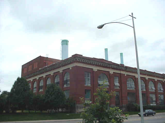
Digital photographs of various personal wireless facilities were taken by the authors. Examples of various types of wireless facilities were chosen such as stealth rooftop, lattice tower, monopole tower, and stealth flagpole. The photographs were then hot-linked to the associated point location of the personal wireless facility shapefile.
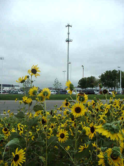
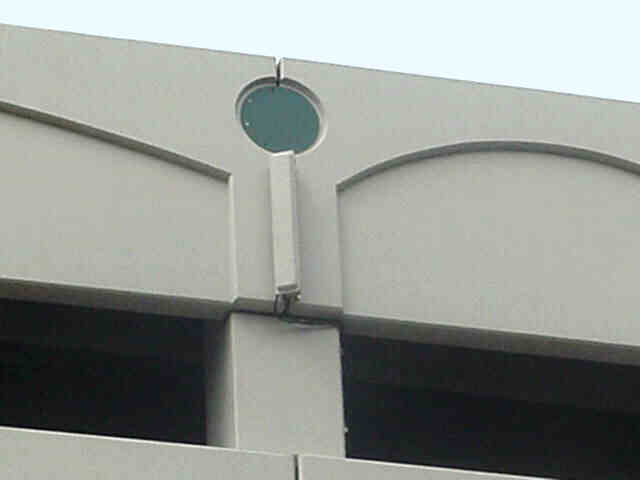
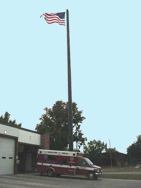
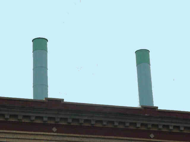
Hot-linking the photo allows the GIS user to view the photo by selecting a specific locational point with the hot-link tool. The photo of that facility then is accessed and appears on the screen. This aspect of the project would allow a planner, among others, to rapidly obtain a basic image of the facility. Although this would not take the place of a site visit, it is an asset for many reasons, for one as it allows the planner to view the existing site while working on a collocation application on that facility. Viewing images could also allow the planner an idea of the "big picture" of the telecommunications industry in the city, and what the various companies' facilities look like after being built. A planner could also share an image with a new company in a pre-application conference as a reference to an exemplary facility design. A few examples of creative stealth facilities in Lincoln appear below (Qwest Wireless, GPS Antenna on public parking garage; AT&T, stealth flagpole; and Sprint PCS, stealth rooftop facility):
Research Applications of the Project
This project addresses current concerns and issues involved with land use planning, personal wireless facilities, and the telecommunications industry. There are three basic uses of this tool that can be applied in a variety of ways and by a diverse range of users. These basic uses are:
Planning Department Research Applications Planning staff could use this project primarily for reference, history and other basic
information on existing towers when writing staff reports. Planners working in the area of
telecommunications could gain a basic understanding of the presence of the industry in their
geographical area in minutes. Data could be especially useful in terms of identifying collocations
on a specific tower. In addition to short term land use planning, the project could be utilized in
long-term planning projects such as language to be adopted into the Comprehensive Plan on
technology and the telecommunication industry, policy review, and other special projects. The
review of the personal wireless facility zoning ordinance may also benefit by staff's ability to
access multiple records of wireless permits and then analyze different aspects of the regulations.
For example, one could explore whether the zoning ordinance is encouraging collocation by
stipulating towers under 80 feet in height must be able to support a second carrier company, and
those towers over taller than 80 feet be able to support at least two other carriers. Private Citizens Research Applications Planners are trained to be aware of the "NIMBY" attitude throughout their career. Public
hearings associated with wireless planning provide a classic example of this "Not in MY back-yard!" sentiment by people across the country. Yet it is important for both the public and private
sectors to recognize this sentiment is derived from the age-old instinct of self-preservation. It is
completely logical that one would be concerned, if not at least curious, about a new technology
being installed on your street-corner. If this sentiment is regarded as human nature, not
necessarily a belligerent cognitive quality, all parties involved could move forward in a smoother
manner. The participation of the general public in wireless zoning approval is almost always very
high, and the educational advantages of a project such as this one, combined with an information
packet on local and national wireless regulations, may be helpful throughout this technological
evolution. Private citizens and the planning departments that are created to serve them are concerned
about the health, safety and welfare of the population. This project would educate citizens on
how the local and federal government currently ensure that these quality of life indicators are
taken into consideration through zoning approval and associated legislation. For example, in the
attribute table the field category "Spno" corresponds to the special permit number assigned to the
personal wireless facility, approved by the city council, which in this case is represented by the
planning commission. Approval is based upon review of the individual application against the
personal wireless facility zoning ordinance, which references governmental policy and legislation
on a local and national level concerning these facilities. The ability to display the special permit
number of each facility, and discuss the major stipulations of the zoning ordinance, would
demonstrate to citizens conformance to standards put forth by the FCC, NEPA, local stipulations
such as submittal of equipment brochures and structural analysis before building permit, etc., in
addition to board recommendations such as from the Urban Design Committee and the Historic
Preservation Commission in Lincoln. Citizens are also very concerned about the aesthetics of their neighborhood, and how a
wireless facility affects their everyday quality of life experience while in and about their
neighborhood, in addition to whether a facility affects their property values. This project would
provide a visual example to the wireless layman concerning facility locations, wireless
companies, and variety of aesthetic designs throughout the city. Currently, citizens would have to
use the project on a computer within the Planing Department, although the project could be
accessible through the city webpage at some point in the future. Prospective Telecommunications Companies Prospective telecommunications companies could also use this project. A company could
gain a general idea of companies and their personal wireless facilities' locations throughout the
City of Lincoln, in addition to more rural areas in Lancaster County. The city and county streets,
zoning districts, document numbers, etc., yield information required on zoning applications. This
may save a wireless company time and money when submitting applications. Public property
opportunities, potential collocations, and examples local of stealth design are all possible
applications. Conclusion The Wireless Planning GIS Project in Lincoln, Nebraska, is a spatial database of
approved city and county special permits for personal wireless facilities in the City of Lincoln
and Lancaster County, Nebraska. The project addresses current concerns and issues involved
with planning and the telecommunications industry, and can be used by city and county planners,
government officials, private citizens, and interested telecommunications companies. There have
been many obstacles, however, including limited time, funding, and staff changes. As with many
planning departments, staff is limited and interns are at times a luxury. In fact, this project would
not have developed this far without the time and effort of our intern. Resources allowing, the
project will continue to evolve and take advantage of the numerous analytical tools provided by
GIS technology. It has been a learning experience which will hopefully be useful to others as
well as ourselves. Acknowledgments: Thanks to the Lincoln/Lancaster Planning Department, Lincoln, Nebraska; Logan Christy, Al
Griffin, Cindy Dittman, and Abu Gadem of the Information and Planning Division of the
Lincoln/Lancaster Planning Department; Natalie Becker, former Lincoln/Lancaster Planning
Department Intern and current Transportation Planner, Colorado Springs, Colorado; Jennifer
Dam, Director, Planning Department, City of Bellevue, Nebraska. Bibliography: City of Lincoln Zoning Book, Title 27, Lincoln Municipal Code, Lincoln, Nebraska:
Lincoln/Lancaster Planning Department, March 7, 2002. Kagan, Julia, Editoral Director "Guide to Cellphones," Consumer Reports, February 2002, p.14. Mayor Don Wesely Progress Report, Office of the Mayor, Lincoln, Nebraska, April, 2002. Author: Abigail P. Davis Planner Lincoln/Lancaster Planning Department Lincoln, Nebraska Endnotes: 1. Kagan, Julia, Editoral Director "Guide to Cellphones," Consumer Reports, February 2002,
p.14.
2. 2. Mayor Don Wesely Progress Report, Office of the Mayor, Lincoln, Nebraska, April, 2002.
reports