Evaluating Cleanup at Hamilton Army Airfield Using EQuIS and ArcGIS
S. D. WEAVER
EarthSoft, Inc., 10820 South 800 East, Paradise, Utah, 84328, USA
email: sweaver@earthsoft.com; www.earthsoft.com
B.A. CALL
US Army Corps of Engineers, Sacramento District, 1325 J Street, Sacramento, CA 95814-2922, USA
email: Bradley.A.Call@usace.army.mil
Abstract The Sacramento District, U.S. Army Corps of Engineers, is implementing EarthSoft's EQuIS and ArcGIS for better management, analysis, and response to landfill remedial activities being conducted at the former Hamilton Army Airfield. This former Air Force Base is located four miles south of the city of Novato, on San Pablo Bay, in Marin County, California, and is undergoing environmental clean-up as it is returned to civilian use.
With borehole, water level, and analytical data stored in EQuIS, the ArcGIS interface facilitates seamless retrieval and display of information including analytical contours, surfaces, and geology in ArcView and in 3D Analyst. Further presentation and analysis utilizes interfaces with gINT, RockWorks, Surfer and GMS.
Introduction
Many military bases in the United States have had environmental clean-up programs in place since the early 1980’s. Several of these facilities have undergone extensive multi-stage investigations and remediation projects that have generated large amounts of data. The management and effective use of the accumulated information for subsequent clean-up work is a daunting task unless electronic data management software tools are implemented. In a number of cases early forms of data management software tools were applied at the military bases; however, the systems were often proprietary and therefore no longer available if the associated consultant left the site. Several environmental science software developers offer systems that can be used to make large data sets more accessible while facilitating data analysis, visualization and utilization. EarthSoft’s Environmental Quality Information System—EQuIS—does this through an ‘open systems’ philosophy that prevents “data hostage” situations. EQuIS has been chosen by many military agencies and organizations, including the Sacramento District of the U.S. Army Corps of Engineers, for the management of analytical chemistry and geology data. The extensive integration with industry-standard applications for visualization and analysis make EQuIS a popular foundation for what is often a comprehensive environmental program or plan.
The implementation of EQuIS Geology at Hamilton Army Airfield by the U.S. Army Corps of Engineers, Sacramento District is reviewed.
A Brief History
From the early twentieth century through the 1970s, ever since toxic and hazardous chemicals and wastes have been produced, they were often dumped improperly because people were not aware of the deleterious effects such contaminants could cause. Starting around the 1950s, due in large part to disasters such as Love Canal, it became evident that the improper handling and disposal of these wastes could cause significant harm to the public health and environment. In 1975, the Department of Defense began to address environmental restoration needs under the Installation Restoration Program (IRP). The overall goal of the IRP was to cleanup previously contaminated lands to an acceptable level of risk on active Army installations as resources and mission requirements allowed. The primary emphasis was on sites that would adversely affect human health, and the secondary emphasis on legal requirements.
In 1980, the United States Congress passed the Comprehensive Environmental Response, Compensation, and Liability Act (CERCLA), commonly known as Superfund. This program established a $1.6 billion fund to locate, investigate, and remediate the most highly contaminated sites nationwide. The Environmental Protection Agency administers the Superfund program in cooperation with state and tribal agencies. The Office of Emergency and Remedial Response oversees administration of the program.
Six years later, in 1986, the Superfund program was rejuvenated by the enactment of SARA, the Superfund Amendments and Reauthorization Act. This legislation made several additions to the provisions of the earlier CERCLA, and modified policies and procedures based on lessons that had been learned during the previous six years of administering the Superfund program. SARA also increased the focus on human health problems associated with contaminated properties. In relation to military facilities, Section 211 of SARA initiated the Defense Environmental Restoration Program, or DERP. (DERP is codified in Sections 2701-2707 of Title 10 of the United States Code.)
The Defense Environmental Restoration Program addressed the Department of Defense’s commitment to cleanup and remediation at active sites under the Installation Restoration Program and at Formerly Used Defense Sites (FUDS). Furthermore, this program was intended to address:
“correcting environmental damage and reducing in a cost effective manner, the risk to human health and the environment from contamination resulting from past DOD activities; encouraging demonstration and validation of technology to reduce hazardous waste generation; and protecting human health and safety by removing unsafe buildings, structures and debris resulting from past DOD operations.”[1]
During the late 1980s and early 1990s Congress and the Department of Defense worked together to identify military facilities that could be closed. In order to improve efficiency, decrease cost, and sustain military readiness, the Base Realignment and Closure Act (BRAC) identified four different groups, or rounds of closures which took place in 1988, 1991, 1993, and 1995. One objective of BRAC was to return property to the community for private, commercial, recreational, and other purposes. However, due to the activities that had taken place on these military installations, in many cases for decades, 206 of the almost 400 facilities identified required some type of cleanup under the DERP program. Since the first round of closures in 1988, 29 major bases and numerous other smaller facilities have been decommissioned, reducing California’s economy by over $9 billion annually, and eliminating over 200,000 jobs. However, the closures ultimately will return over 77,000 acres of land to the surrounding communities.
One of the six major bases designated for closure in the first round of BRAC in 1988 was Hamilton Army Airfield.
Hamilton Army Airfield
Hamilton Army Airfield, near Novato, California, is a former military base in the process of conversion to civilian use. Environmental clean-up activities have been ongoing at the base since approximately 1985 and have included investigation and remediation of dozens of locations. One of the larger sites, located in a low lying area in the north section of the base, is the former garbage dump, now referred to as Landfill 26. Landfill 26 is approximately 15 acres in extent with an overlying impermeable cap about 26 acres in size. The landfill lies in a shallow valley formed by Novato Creek as it entered the tidal wetlands that historically bordered San Pablo Bay. The land occupied by the former base was reclaimed, originally for agricultural purposes, in the late 1800’s and Novato Creek was redirected in a man-made channel away from the landfill. Initial investigations determined that Landfill 26 was non-methanogenic. Subsequent landfill gas monitoring, however, has found sporadic methane concentrations beginning in 1998. This discovery has triggered additional investigations and remedial activities at the landfill and surrounding area.
Large amounts of environmental data have been gathered at Landfill 26, beginning with investigations of soil and refuse, followed with an extensive groundwater monitoring program, and continuing with the methane investigations. The type of data gathered includes chemical testing results (soil, soil gas, surface water, sediment, and groundwater), groundwater elevation and soil lithology. Information has also been gathered on features that have changed with time such as topography, building locations, landfill cap construction details, new residential developments and underground utilities. Electronic data management is necessary when working with such a large data set (over 50,000 individual chemistry data points alone) combined with the need to present information to both regulatory agencies and the public.
Most of the data collected at this site were managed as bound reports, however some partial attempts were made to utilize electronic storage such as spreadsheets and databases. The early database efforts were not connected to any form of Geographical Information System (GIS) and so it was difficult to make effective use of the data. Because of these problems the initial databases were “placed on the shelf” and were not further developed. A large number of bound reports have been generated over the years and their management is a significant effort requiring large amounts of storage space and dedicated resources to archive and retrieve the information. While the data was safely stored in the reports, it was not easily accessible or always in a format facilitating effective analysis.
ELECTRONIC DATA MANAGEMENT
To effectively manage the investigation and remediation of Landfill 26 the project team defined the following tasks:
- Display various combinations of contaminant information on accurate scale maps of the site
- Explore trends in groundwater contaminant concentrations over time
- Understand the spatial relationships of contaminants in soil, soil gas and groundwater
- Produce groundwater elevation maps
- Model contaminant movement in groundwater
- Check for relationships between buried utilities and detected contaminants
- Visualize the site stratigraphy in both two and three dimensions
To implement comprehensive electronic data management for the Landfill 26 project it was decided to obtain software that would facilitate the creation of a single database that could be utilized by analysis applications already in use by the Corps of Engineers such as Surfer and RockWorks. The electronic data management application chosen for this project was EQuIS Geology, which would be teamed with ArcView 8.x, Surfer, RockWorks, gINT, and GMS.
Data Usability
One scenario frequently encountered among environmental data managers is the ‘data hostage’ situation. This problem may result not only from the use of a proprietary database that prevents ‘back-door’ access to data, but also from the process of storing data in a particular visualization or analysis application. The open systems architecture upon which EQuIS is based provides the opportunity for a data manager to access data directly, outside of the user interface. This philosophy is rapidly gaining wide acceptance as users are able to go directly into the database to build custom queries and write need-specific applications for reporting and formatting data. Whereas the EQuIS user interface provides an extensive suite of reporting tools and interfaces for sending data to many different visualization and analysis applications, the open system design also allows the development of custom interfaces without being bound by the cost and time requirements of the developer as is often the case with closed, proprietary systems.
Another benefit of the open systems architecture is that the user is not locked into a specific visualization or analysis application. They may choose between any of several popular tools for creating borehole logs, groundwater models, solid models, or performing other types of analysis. This flexibility provides the opportunity to switch to a higher-level application if the currently used application is not adequate without migrating data to a new system. Many proprietary systems provide their own visualization and analysis tools and if these do not prove adequate, the user is at the mercy of the developer or is required to migrate their data to a more suitable system. Proprietary evaluation tools are also often poorly documented as to the application of algorithms and are not generally accepted throughout the industry. This creates a situation where disagreement may occur between a facility and the regulating entity as to the applicability of the evaluation tool.
The dangers of storing data in a specific visualization or analysis tool are illustrated by the hypothetical case of a project manager who has successfully used a groundwater modeling environment to produce the results needed by his client. However, when the client then needs borehole logs, cross-sections, or solid models in addition to the groundwater modeling, the manager is left in a quandary. Heretofore, the solution has been the costly investment not only in an additional product and the time required to learn the procedures necessary to produce the desired results, but also in understanding file formats and migrating the appropriate data into the new application. EQuIS greatly simplifies this task by facilitating the creation of borehole logs, cross-sections, fence diagrams, reports, contours, groundwater models, solid models, and more all very quickly and easily…without having to understand the intricacies of specific file formats. This mechanism permits more time to be devoted to science and analysis rather than the overhead of a specific piece of software.
Landfill 26
The discovery of methane at Landfill 26 made it necessary to evaluate not just the most recently acquired data, but also to combine this with the extensive information collected during past investigations. The goal was to understand where the methane was generated and its movement away from the landfill. This required consideration of the contents of the refuse, the exact configuration of the refuse cells, the presence of historic and newly installed underground utilities, specific contaminant concentrations, and the geology beneath both the landfill and the surrounding areas.
The first step was to assemble bound reports and plans dating back to 1986. These reports were supplemented with some information contained in spreadsheets and databases produced for previous investigations. While these earlier attempts as creating electronic data were not completely successful, they did provide a valuable “spring board” towards the production of a comprehensive data management system. Using both the reports and electronic data, electronic data deliverables (EDDs) were prepared for:
- chemistry data (soil, groundwater, soil gas)
- location and elevation information
- groundwater elevation data
- lithology data
- well construction data
These EDDs contained information from approximately 30 investigations or monitoring events, conducted by both the Army and consultants working for property developers who had purchased portions of the former base. Data from approximately 50 monitoring wells, 250 soil borings, 150 soil gas probes, and hundreds of individual chemical sample locations will eventually be incorporated. Excel spreadsheets were used for the creation of the EDDs, which were subsequently loaded into the EQuIS system. The ability to use spreadsheets for this initial input of historical data was very beneficial to the project team who had limited experience with the use of relational databases. Creating electronic data management systems for historical data is a time consuming data entry task that requires careful planning and quality control procedures to ensure a successful application. Early decisions taken to establish the required data (as a portion of all of the available information) paid large dividends in reducing the overall effort required. The project team was also faced with the need to determine the comparability of older chemistry tests with current methods (to allow for consolidation in the database which would lead to more effective analysis and presentation).
Geologic interpretation varies according to the method of investigation and the professional judgment of the consultants involved. Geologic investigation methods utilized at Landfill 26 included boreholes, potholes, trenches and cone penetrometer test (CPT) techniques. There will be an effort to bring some degree of uniformity to the overall interpretation. Re-interpretation was done for this project, however the EQuIS system allows the storage of up to five various interpretations for any one location—called ‘geologic units’—which reduces the chance that valuable site data will be lost. An additional benefit of adding the geologic data to the system was that it is possible to produce uniform high quality boring logs (using gINT for this project).
Once a significant amount of the data had been loaded in the electronic data management system, ArcGIS was used to view chemistry data from various investigative phases superimposed over the project site. ArcGIS layers were prepared that allowed simultaneous depiction of various land surfaces, utilities, waste cells, and the geology. By superimposing contaminant information over various combinations of these layers it was possible to check for sources of methane generation, preferential pathways, and potential associations with historical Hamilton Army Airfield buildings.
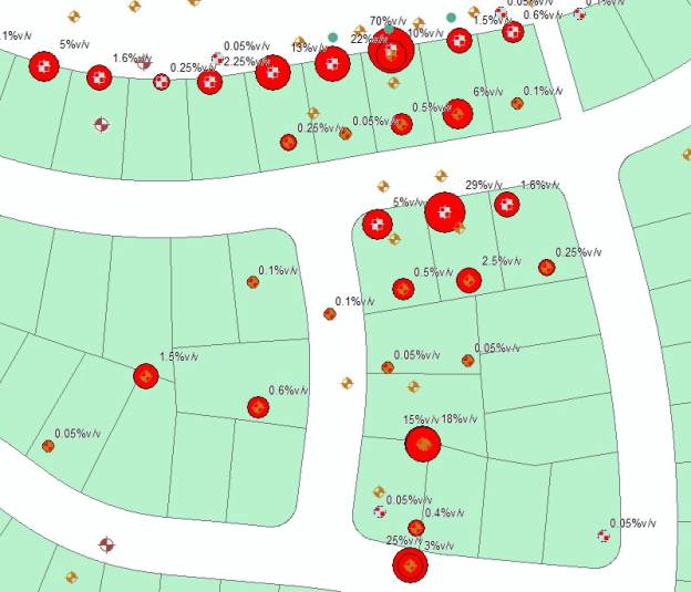
Figure 1. Methane concentrations (%v/v) at soil gas probe locations in relation to lots south of Landfill 26.
The geology of the area is complex with alluvium overlying fine-grained sediments, known locally as Bay Mud, which in turn overlies sandstone bedrock. Buried former stream deposits traverse the area as indicated by accumulations of sands and gravels within channels in the bedrock. Groundwater is shallow, found at an average of 10 feet below the ground surface. As the remnants of a former marsh, the Bay Mud represents a potential source of methane and as such the project team wanted the most accurate view possible of its location. The buried stream channels also represented potential preferential pathways. Once the electronic data management system is complete the project team plans to produce geologic cross sections and areal views showing key features and stratigraphic units that may contribute to the origin and transport of the methane.
ArcGIS provides a rich editing environment and professional cartography tools in its ArcMap product for the creation of boundary lines and offers from over 5,000 customizable symbols out-of-the box to represent map features. Styles can help maintain standards for symbols, colors, patterns, and methods of rendering distributions, relationships, and trends. EQuIS for ArcGIS supports the ArcMap Style gallery by providing a customizable EarthSoft style gallery which it then uses when creating any of its automated map features, such as sample locations, color ramps, scale bars, etc.
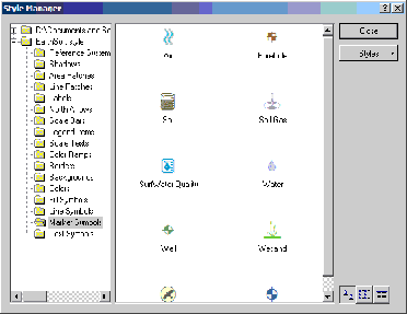
Figure 3. EQuIS for ArcGIS Style Manager
EQuIS for ArcGIS is an extension to ArcMap and ArcScene (3D Analyst 8.x), so all of the features of the full-fledged ArcGIS applications are available to the user. These include core GIS functionality, such as layer control. Layers may be turned on or off by either checking a box next to each layer, or via zoom-levels, where more features are shown as the user zooms up on a map, and less are shown as the user zooms away from the map. For the Hamilton Army Airfield and Landfill 26, all associated data layers can be displayed, including major roads and building outlines, topographic contours, minor roads, minor buildings, water features, monitoring wells, soil sample locations, extraction wells, orthophotos, SWMUs, site groups, property boundaries, and utilities.
The EQuIS for ArcGIS Extension integrates the leading environmental software packages for specialized tasks, such as contouring with Surfer. These contours are then brought back into the GIS, where they can be used in further analyses with output from other non-GIS applications, such as RockWorks for geologic cross-sections.
Any sample locations from the EQuIS application databases can be displayed by simply running an ‘Add Project’ wizard. For example, monitoring well locations as well as individual sample points for soil and soil gas are displayed each with a custom, per-project symbol.
Analytical data may be queried, and presented in several ways, including crosstab summary format. Using the Chemical Layer Builder, the selection is defined using a specific media (water, soil, or soil gas for example). When dealing with a single event (or sample points sampled only once) the data can either be shown for each sample location using a symbol indicating relative concentration. Using the standard ArcMap info tool, all available data (or the desired subset) for individual sample points can be browsed. EarthSoft provides a similar tool as well, called the EQuIS Project View tool, where all data tables related to any particular sampling location can be viewed in the GIS as well in EQuIS geology.
With the EQuIS EZView LayerBuilder integrated into the GIS, reporting and time-series plots are offered for a variety of scenarios, including plotting concentration vs. time, for example using various grouping methods, location groups, well groups, analyte groups, etc.
Integration with both RockWare’s LogPlot and Geotechnical Computer Application’s gINT software allows for the display of monitoring well completion diagrams and creation of boring logs on the fly, all from within the GIS. The filenames of any boring logs already created in PDF or image file format, can be saved as attributes of those stations, and using standard ArcMap hyperlink tools, can be displayed when selecting those stations.
The EQuIS for ArcGIS interface provides a user-friendly spatial environment where geologic, analytical, and spatial data are brought together to build a complete picture of an environmental facility. Using data from Landfill 26 at Hamilton Army Airfield many different analyses, logs, reports, and models were created to enhance decision-making. These tools are available to the casual user; no longer is a GIS expert required to conduct a spatial analysis in GIS.
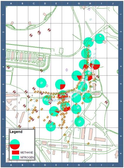
Figure 4. Indexed map showing relative methane and nitrogen concentrations at Landfill 26.
CONCLUSION
The Landfill 26 site has a long history of environmental activities and has amassed large amounts of data. In years past, the only available option to gain a comprehensive impression of the accumulated data for a site such as this was to conduct an expensive and time-consuming evaluation. When software analysis programs were utilized it was often necessary to input the data into each application individually, thus multiplying the data entry process several fold. The current electronic data management software holds the promise of providing a truly integrated system of data storage and analysis, which is expected to significantly improve the project teams ability to utilize the entire accumulated dataset and to respond effectively to contamination issues at the landfill.