|
Michael DePrez, Los Angeles Department of Water and Power |
|
Andrew Baldwin, Montgomery Watson Harza |
|
Tom McCarthy, Montgomery Watson Harza |
Utilizing a GIS has assisted in the overall understanding and management of the water resources system in the Owens Valley, California. Use of the GIS helps organize assets such as flow gauges and weather stations as well as spatial data such as rivers, streams, soil moisture, vegetation, soils, and geology. The use of GIS as an integral tool has helped to understand a vast and complex system.
Los Angeles Department of Water and Power (LADWP) Northern District is developing a GIS data management system to service all departments within the organization providing high quality mapping data, fast and extensible data access, seamless integration between software systems, and robust data management. These data will be utilized with numerical groundwater models and numerical vegetation models to develop improved management practices. To accomplish this, the GIS Task Team is developing a GIS data management system to support LADWP's data collection, management and data analysis needs.
This paper describes the work completed on the project at the time of submission and outlines the tasks required to develop a fully comprehensive GIS data management system.
The project commenced with an initial investigation into the GIS requirements and expectations of the system users.The focus of this phase of the project was to develop a GIS implementation plan identifying data needs and solutions with sufficient detail to commence the development of the GIS data management system.
The GIS Implementation plan focused on the following activities:
This section summarizes the findings from workshops and previous GIS studies conducted. The key components of a GIS / data management system are:
The above features of a GIS data management system provide a framework for categorizing the requirements. In addition, these features are used to organize the tasks required for implementing the GIS system.
Data flow analysis is an essential tool for understanding the utilization of GIS data to perform the day-to-day activities. This type of analysis allows common tasks such as map production, vegetation analysis, and so forth. Subsequently, the analysis allows the consultant to specify associated data inputs and outputs for common tasks. This process has enabled the team to synthesize the flow of data throughout the Northern District organization and to develop initial data management procedures. The data flow analysis is based on the Gane-Sarson (Gane and Sarson, 1977) notation to display the basic elements that describe the data flow processes.
The elements include:
A formal, structured database design process is required to ensure that the GIS database adequately supports LADWP management business functions. Computer Aided Systems Engineering (CASE) methods and tools will assist with the data modeling, database development, documentation, and implementation of the accepted GIS data model.
The term "data model" is used to define a set of rules according to which data is structured. Basically, a data model is any method of visualizing the informational needs of a system and typically takes the form of an ERD (Entity Relationship Diagram). A data model comprises of an integrated collection of tools describing data, relationships and data constraints.
The data modeling will consider utilizing 'ready-made' data models developed by Esri and used by the arcs software. The ArcGIS data models provide ready-to-use nonproprietary frameworks for modeling and capturing the behavior of real-world objects in a geodatabase. They are built on the accepted standards in each field and provide data models that can be configured and customized using ArcEditor or ArcInfo. Data modeling and database designs will be conducted for the 6 data categories listed in the table below.
|
Preliminary List of Database Design Categories |
|
|
Data Set |
Database Design Focus |
|
Basemap |
Roads,rivers / streams, contours, lakes, rail, utilities, transmission lines, ortho-photo data |
|
Hydrogeological |
Soil moisture, transects, groundwater basins, borehole locations, model results |
|
Vegetation |
Vegetation, soils, rare plants, sensitive wildlife areas, fisheries |
|
Hydro Infrastructure |
Water facilities, pumps, pipes/channels, gates, dams, flumes, diversions |
|
Survey |
Easements, elevations, GPS data, address books, field survey book cards, subsidence |
|
Property / Real Estate |
Parcels, easements, buildings, historic buildings, LADWP-owed and leased property |
Since LADWP will be storing large and complex sets of data files in a wide variety of formats, the file server must directory structure. The core GIS data management system will provide an interface between the user and the file server. The interface will have the following functionality:
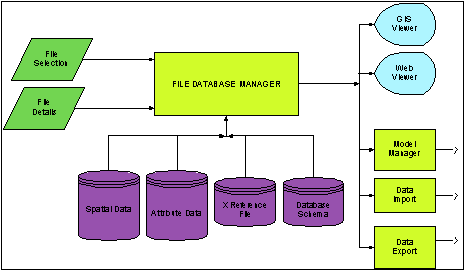
The GIS data management system will manage the storage, access and viewing of spatial and attribute data. The spatial data will be stored in separate ArcView SHP files, with a key field relating spatial features to attributes stored in separate databases. When the user loads a theme into the GIS view window, the core GIS data management system will automatically find the corresponding database and attach the data to the theme. This approach allows different attribute databases to be attached to corresponding themes. For example, the well theme can have borehole data, pumping data and facility information all associated to the same theme.
A system for managing the spatial and attribute data will be developed and integrated in the core GIS data management system. The following data flow diagram shows the basic components of the proposed file management system.
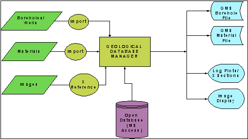
A hydrogeologic database has been designed to store and manage geologic and groundwater data. The data consist of the following datasets, which may be viewed as tables within the database:
Preliminary analysis of geologic components and data flow issues provided the following data flow diagram. The diagram shows the input data (green symbols), import processes and database manager (yellow symbols), a data repository (purple symbol) and finally the outputs (blue symbols). This preliminary analysis will be developed and combined with hydro-based components to create a comprehensive hydrogeologic database system.
Borehole data entry and viewing tools allow the user to store electronically borehole data and generate plots, cross-sections and fence diagrams. Many software products are available for borehole data entry and viewing. Borehole data entry and viewing software are being integrated with the hydrogeologic database system. The integration process will enable data to be transferred easily from one package to another. This seamless data transfer will reduce data management errors and maintain a high level of data integrity
Generating and drawing geologic cross-sections requires a skilled geologist to interpolate the borehole logs and develop the stratigraphy. To assist in this process, software tools will generate a 'first-cut' at cross-sections or fence diagrams allowing the geologist to modify the stratigraphy as necessary.
| Mike DePrez, Civil Engineering Drafting Technician |
| Los Angeles Department of Water and Power |
| 300 Mandich Street |
| Bishop, California |
| Ph:(760) 873-0261 |
|
Fax: (760) 873-0266 |
| Mike.deprez@water.ladwp.com |
| Andrew Baldwin, Principal Engineer |
|
MWH, Inc. |
| 1230 Columbia Street, Suite 750 |
| San Diego, California |
| Ph: (619) 239-3888 |
| Fax: (619) 239-3895 |
| Andrew.baldwin@mwhglobal.com |
| Tom McCarthy, Engineer |
|
MWH, Inc. |
| 1230 Columbia Street, Suite 750 |
| San Diego, California |
| Ph: (619) 239-3888 |
| Fax: (619) 239-3895 |
| Thomas.mccarthy@mwhglobal.com |