Pipeline safety rules are currently being promulgated by the U.S. Department of Transportation (DOT) regarding integrity management for hazardous liquid and natural gas pipelines. The pipeline industry is required to continually assess the integrity of pipelines that have potential to affect high consequence areas (HCAs) as defined by the Office of Pipeline Safety (49 CFR Parts 195). This paper explains how HCAs are identified and how operators can use the resource data behind HCAs to cost-effectively facilitate compliance and improve communication and decisions about "could affect" HCAs from the planning department to the emergency response team.
In December 2000, the first pipeline safety regulations regarding integrity management were promulgated: "Areas Unusually Sensitive to Environmental Damage" and "Pipeline Integrity Management in High Consequence Areas (Hazardous Liquid Operators with 500 or More Miles of Pipeline)" (49 CFR Parts 195). Several more pipeline safety rulemakings specific to smaller hazardous liquid operators, as well as natural gas operators, are expected to become final later in 2002 and 2003. The Office of Pipeline Safety (OPS) considers high consequence areas (HCAs) as:
Commercially Navigable Waterways;
Populated Areas; and
Unusually Sensitive Areas (USAs).
Not much has been published on the GIS process used to identify HCAs. This paper sheds light on the GIS resource data behind HCAs. It describes their content and quality and imparts information about ancillary data pertinent to assessing potential effects on HCAs that are not considered in the identification process employed by OPS.
As with any GIS model, the quality of the input data directly affects the reliability of the analytical results. HCAs were intended to be a nationwide overview of areas that contain our country’s most sensitive resources, both human and environmental. From a GIS perspective, to say that an area mapped at a nationwide scale will translate precisely to current conditions along a pipeline’s right-of-way is inviting distortion and miscommunication about reality. The truth is that HCAs are identified from the best possible standardized data sources available today. Some of these data sources are excellent examples of GIS data, fully documented and precisely mapped. Others are from entities that have recently discovered GIS and are working to convert their databases from legacy systems. By researching the resource data behind "could affect" HCAs during the risk assessment process, an operator can effectively deduce which HCAs could truly be affected, ultimately reducing anticipated costs and workloads.
OPS considers commercially navigable waterways as high consequence areas because of their unique significance to the U.S. economy and defense system. For integrity management, operators should focus their assessment on whether an accidental release could interrupt the supply operations of nearby commercially navigable waterways, rather than automatically accepting that all spill model trajectories intersecting a commercially navigable waterway have the potential to affect the HCA under the integrity management rule.
OPS provides digital maps of U.S. commercially navigable waterways to operators through the National Pipeline Mapping System (NPMS). The data are a subset of the National Waterway Network produced by the Bureau of Transportation Statistics and have varying degrees of mapping accuracy with scales ranging from detailed (1:24,000) to highly generalized (1:1,200,000). Mapping scale and accuracy are generally better in harbors, bays, and ports.
It is important to note that line segments in this dataset are representative of shipping lanes. The lines have no width like true waterways and may not accurately reflect natural curvatures. Due to the wide variance in source scales, this dataset is best used as a guide to the physical location of commercially navigable waterways in the U.S. Other more detailed sources of digital hydrography can then be used to precisely map the watercourses in relation to pipeline corridors.
Figure 1 depicts commercially navigable waterways near Fairbanks, Alaska. Possibly due to the application of a large snap tolerance, the natural connection of these waterways (in blue) was collapsed resulting in the representation shown by the NPMS dataset (in pink). The commercially navigable waterways can be readily determined by listing the names of the NPMS line segments in this area, but the true shipping paths are more exactly mapped by other digital hydrography datasets, such as the one shown here in blue developed by the Alaska Department of Natural Resources.
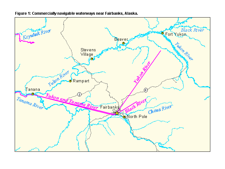
Figure 2 shows a commercially navigable waterway from the NPMS (in pink) overlaid on a 1:100,000-scale hydrography map downloaded from the U.S. Geological Survey (USGS), http://edc.usgs.gov/geodata/. Performing a simple GIS intersection of the NPMS waterway with nearby pipelines (in brown) would infer that there is no potential to affect, because these line segments do not cross one another. A closer look at the lakes and rivers in the area yields a different answer, however. By adding the dimensions of river width and flow direction, a clearer picture emerges regarding a pipeline’s potential to affect the commercially navigable waterway.
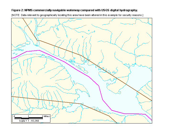 [NOTE: Data relevant to geographically locating this area have been altered in this example for security reasons.]">
One logical inclusion as a high consequence area are places where people congregate. The Census Bureau has made great strides in mapping communities across the U.S. and their data is used by OPS to identify the populated area HCAs. As with the commercially navigable waterways dataset, though, populated area data are also derived from sources of varying degrees of mapping accuracy and are not suitable for high-precision measurement applications, which may include the more comprehensive spill models or risk assessment methodologies. The dataset currently available on the NPMS is from the 1990 census. The Census 2000 data has recently been released and OPS is in the process of making the information available to operators through the NPMS as updated map layers of "high population areas" and "other populated areas".
The purpose of populated area HCAs is to identify places where pipelines may pose a threat to public safety. This intent was aptly met with the 1990 Census Bureau definitions of urbanized areas (for OPS’s "high population areas") and census-designated places (for OPS’s "other populated areas"). The urbanized area (UA) designation has the same minimum population requirement for every state in the U.S. Urbanized areas are defined as a continuously built-up area with a population of 50,000 or more or a population density of at least 1,000 people per square mile. Census-designated places (CDPs) are defined as settled population centers with a definite residential core and a degree of local identity, with a population of 1,000 or more. To account for the significance of smaller communities on American Indian reservations, the population threshold is 250 or more; in Alaska, the population threshold is 25.
Due to their nature, however, the definitions of Census Bureau designations change over time to better characterize the dynamic growth of our communities and enhance differentiation among geographic units of population. The Census Bureau acknowledges these changes can affect other agencies that rely on the definitions for implementing various programs and urges the agencies to use sufficient descriptive terminology to avoid confusion when change does occur.
Changes to the criteria of urbanized areas and CDPs did occur in the 2000 census. Urbanized areas still have the same minimum population requirement for every state in the U.S. and are considered a continuously built-up area with a population of 50,000 or more, but the population density threshold has dropped from 1,000 people per square mile (ppsm) to 500 ppsm.
The change to the CDP criteria is more noticeable in its translation to "other populated areas" under the integrity management rule. In April 2000, the Census Bureau eliminated the population threshold for CDPs altogether. The change stems from the philosophy of a "place" as recognized by the Census Bureau. The Geographic Areas Reference Manual defines a place as "a concentration of population; a place may or may not have legally prescribed limits, powers, or functions. This concentration of population must have a name, be locally recognized, and not be part of any other place". According to the Census Bureau, a "concentration of population" should not depend on a minimum population requirement. The Census Bureau initiated a program from 1996 - 1999 to delineate CDPs for the 2000 census. The program was conducted by local agencies, which were trusted to identify and delineate CDPs within their districts as they best saw fit.
The change in the definition of CDPs warrants care in how populated area HCAs should be assessed during integrity management. Fortunately, most CDPs appear logically placed and reflect a natural spread around the perimeter of a urbanized area or are representative of a small community that has sustained considerable growth in the past 10 years. It is important to note, however, that a few CDPs do vary widely in shape and size, seemingly independent of like patterns in population density or distribution. The Census Bureau has additional information on individual CDPs that can assist in determining whether a populated area HCA could truly be affected by an accidental release, see http://www.census.gov/geo/www/cob/pl2000.html.
Figure 3 depicts populated area HCAs in southwestern Montana according to the Census 2000 data. The city of Missoula is the only populated area in this region that meets the urbanized area criteria (red). The other populated areas meet the Census 2000 CDP criteria (green), although the size of some of these shaded areas varies widely with no apparent correlation to their total population count.
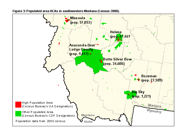
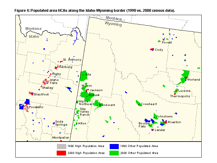
Figure 4 shows the differences in populated HCAs along the Idaho-Wyoming border using 1990 census data versus 2000 census data. This map was created by overlaying 1990 data on 2000 data, in order to highlight those areas that would be new additions to the populated HCA layer according to the 2000 census (see the red and green areas). There are a few additions to high population areas between 1990 and 2000 (in red), but no real surprises. The difference in other populated areas is quite marked, though. Because 1990 CDPs were not automatically grand fathered in, there is little correlation between places identified as a 1990 other populated area (blue) and new 2000 other populated areas (green). In addition, large expanses have been delineated as 2000 other populated areas (in green), most likely a direct result of no minimum population requirement.
OPS defines unusually sensitive areas (USAs) as places that contain drinking water and ecological resources that are potentially more susceptible to long-term, irreversible, or irretrievable damage from a pipeline accident. Drinking water and ecological USAs are available to operators through the NPMS. OPS is not able to provide operators with the original resource data that drives the identification of USAs due to recent issues regarding homeland security, data licensing agreements, and the shear amount of information that is housed in myriad databases. This background resource information holds the key to understanding the nature of a USA, however. Understanding what a USA signifies not only aids in determining if a pipeline release has the potential to affect the USA, but also focuses an operator’s efforts during risk assessment, mitigation, and emergency response.
Drinking water USA resource data typically come from state health departments. The data are usually free, although some states charge a processing fee to fulfill requests. Since 9/11, the U.S. Environmental Protection Agency (EPA) has deemed public water system data a homeland security risk, so now coordinate information is only released through a Freedom of Information Act and delays can be several weeks. Some states are also requiring confidentiality agreements before releasing any data in order to keep track of the data distribution. A good starting point for state public water system information is http://www.epa.gov/safewater/source/contacts.html.
Many state agencies in charge of public water system databases are relatively new to GIS and have not yet worked out a system to easily handle ad-hoc data requests. In addition, there is no adhered-to data structure between state public water system databases. Much of the data are not well documented and pertinent attributes about individual systems can be scattered across several databases independently maintained by different branch offices under the same state agency. Fortunately, all states now have an EPA-approved Source Water Protection Program and are currently undergoing a rigorous assessment of their water sources that is anticipated to be complete nationwide by 2003.
Since the rulings called for USAs to be identified before the states could complete their source water assessments, OPS has had the arduous task of gathering 50 states worth of public water system data and sorting through millions of records to locate attributes that meet the USA criteria. The effort involved multiple back-and-forth transactions between state agency offices to fill in data gaps and settle attribute discrepancies. For some states, attributes or map themes relevant to identifying USAs were simply not available and assumptions had to be made to provide something for operators to work with in the time being.
The drinking water USA model ascertains a drinking water system’s uniqueness based on its attributes. To receive USA status, the system must be physically located within 1 minute (or 1 mile) of its mapped coordinates. It must be active, designated as a community or non-transient non-community water source, and have no adequate alternative available in the event of contamination. If the system is a groundwater well, the source aquifer must be classified as vulnerable to surface contamination (Class I or IIa, per Pettyjohn et al., 1991). Besides qualifying groundwater wells, springs, and surface water intakes, all recharge areas of sole source aquifers that are karst in nature are also considered drinking water USAs. USA-pertinent information for public water systems include:
Public Water System Identifier (PWS-ID);
System Name;
Geographic Coordinates;
Mapping Precision (general, minute, second);
Activity Code (active or inactive);
System Type (community, non-community, transient, or non-transient);
Source Type (groundwater, surface water, or spring);
Well Depth (if a groundwater well);
Source Aquifer (if a groundwater well);
Population Served;
Contact / Operator Information;
Source Water Protection Area;
Wellhead Protection Area; and
Availability of an Adequate Alternative Water Source.
Public water system databases store drinking water sources as points. Using ArcInfo, the USA model identifies an area of unusual sensitivity (or USA) for these points. For groundwater wells, the model employs the wellhead protection area (WHPA) or source water protection area (SWPA) for the USA boundary. If a SWPA has not been delineated for a surface water intake, a 5-mile buffer circle is inscribed around the intake and all surface water features (lakes, rivers, streams, etc.) within the circle are buffered to a quarter-mile to account for important riparian areas along shorelines and stream banks. This derivation of points into areas results in three recognizable patterns: solid circles (WHPAs), ellipses or irregular-shaped polygons (SWPAs), and brain-like dendritic circles (surface water sources).
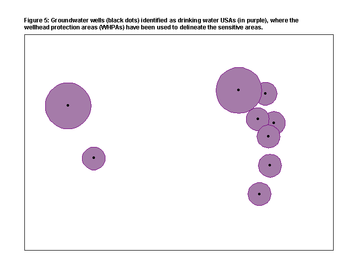
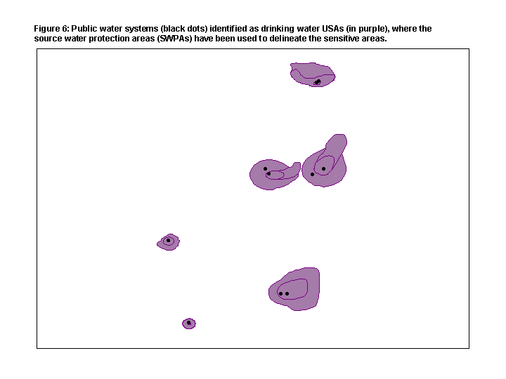
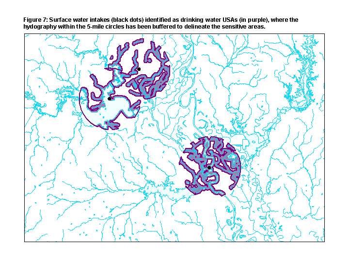
Even though a drinking water USA may intersect a pipeline or a pipeline’s right-of-way, it does not automatically infer that the USA could be affected by an accidental release from the pipeline. As figures 5 through 7 show, the actual water source is a point location. If the source water location is upstream or up gradient from the pipeline, there may be little chance that a spill could reach it. By incorporating GIS data relating to surface water and groundwater features in the risk assessment process, operators can better evaluate a pipeline’s potential to affect a drinking water USA. Understanding the interplay of hydrography, topography, stream flow, and underlying aquifer systems can effectively improve predictions about the direction and speed of transport from an accidental event.
In the course of identifying USAs, OPS developed tables that cross-match each drinking water USA with its state public water system identifier (PWS-ID) through the DWUNIQUE# field of the USA region attribute table. Using the PWS-ID to track back to state drinking water databases, an operator can find out more information about the drinking water USAs that their pipelines could potentially affect.
Many states have their public water system databases online and a simple query using the PWS-ID will return a description of the drinking water system. Considering the vast amount of data that OPS compiled and analyzed to identify USAs for the nation and the current condition of state public water system databases, it is possible that certain USA-pertinent information about a drinking water system was not properly communicated to OPS. An operator can effectively reduce the number of "could affect" USAs along the pipeline system, simply by bringing this information to light through a little research and documentation.
Table 1 lists the record for a drinking water USA identified by OPS. The fields shown are typically inherent in all public water system databases. USA-pertinent attributes are highlighted in yellow. This record indicates that the drinking water system was closed in 1999. It is highly probable that OPS was not privy to this information when identifying USAs for this state, but this information is valuable to operators when explaining why this USA could not be affected.
![Table 1: Public water system database record for a drinking water USA. [NOTE: Data relevant to geographically locating this system have been altered in this example for security reasons.]](p09528.gif)
Drinking water USAs are divided into two categories: final and interim. Interim USAs are missing data that indicate whether the drinking water source has an adequate alternative. As defined in 49 CFR 195.6, an adequate alternative drinking water source is a source of water that currently exists and can be used almost immediately with a minimal amount of effort and cost. There is no decline in water quality and the alternative source will meet the consumptive, hygiene, and fire fighting requirements of the existing population of impacted customers for at least one month for a surface water source and at least six months for a groundwater source.
In general, someone usually knows whether they have an alternative source for their primary drinking water system or not. Unfortunately, this type of information is traditionally not maintained in state public water system databases. The availability of this information should improve as state source water protection databases come online. In the meantime, interim drinking water USAs indicate those USAs where OPS was unable to track down data about alternative sources due to time or resource constraints. Information about contact personnel, owners, or operators of drinking water interim USAs is available through state drinking water agencies. The names and addresses on the lists can be used to identify individuals that have specific knowledge about alternatives to individual drinking water sources. Drinking water USAs that have documented alternative sources no longer meet the definition of a USA, which would effectively remove the drinking water source from an operator’s list of "could affect" USAs.
When collecting drinking water resource data about "could affect" USAs, it is important to consider both wellhead protection areas (WHPAs) and source water protection areas (SWPAs). Although WHPAs are primarily used to delineate drinking water USAs with groundwater sources, the USA model uses SWPAs when available and has a placeholder to solely use SWPAs, once the states complete their programs in 2003. Most states define WHPAs using a simple arbitrary fixed radius method (inscribing a circle around a well location), whereas SWPAs are typically defined using more sophisticated analytical methods. SWPAs refine the potential contamination area of a water source and may actually cover less area than a WHPA, depending on the methodology employed by the state. Understanding how a USA’s shape changes when the SWPA is used may eliminate the potential to affect a drinking water source altogether.
Most ecological USA resource data come from natural heritage programs. The natural heritage programs are typically state governmental agencies, although a few programs are supported through universities or Nature Conservancy offices. The role of these programs is to gather, manage, and distribute detailed information about the biological diversity found within their jurisdictions. Natural heritage programs are our nation’s leading source of information on the exact locations and conditions of rare and threatened species and ecological communities.
Natural heritage programs are members of a non-profit organization called NatureServe, which was established in 1999 by a consortium of the state programs and The Nature Conservancy. NatureServe is an independent organization that assists its members in the collection, analysis, and public distribution of biodiversity data. The umbrella organization functions as the national data warehouse for the species occurrence information behind most ecological USAs. NatureServe assisted OPS in the USA effort by efficiently amassing data about rare plants and animals collected by the 50 state programs and compiling the information into a single data structure, performing quality control measures throughout the process. The final state datasets were provided to OPS for insertion into the USA model. To find out more about NatureServe, as well as locate links to the 50 state natural heritage programs, see http://www.natureserve.org/index.htm.
For species occurrence data, the ecological USA model ascertains uniqueness based on attributes maintained in the biodiversity database. To receive USA status, the occurrence must be physically located within 1 minute (or 1 mile) of its mapped coordinates. On a global scale, the species or subspecies must be critically imperiled (5 or fewer occurrences or < 1000 individuals left). Species that are globally imperiled (6-20 occurrences or 1000–3000 individuals left); federally listed as threatened, endangered, or an essential experimental population; or listed as a depleted marine mammal are considered USAs if they are part of a multi-species assemblage area; are associated with aquatic habitat or have a limited terrestrial home range; or exemplify a high quality occurrence. Occurrences meeting these criteria cannot be designated as historical in their global or state conservation ranks. Ecological USAs also include Western Hemisphere Shorebird Reserve Network (WHSRN) sites designated as hemispheric, international, or endangered species reserves and Wetlands of International Importance (Ramsar sites) that are designated especially as waterfowl habitat. USA-pertinent information for species occurrences include:
Species (or Element) Occurrence Code (EOCODE);
Scientific Name;
Common Name;
Geographic Coordinates;
Mapping Precision (general, minute, second);
Federal Status (threatened, endangered, or experimental population);
Global Conservation Status (critically imperiled, imperiled, vulnerable, secure, or extinct);
Viability Ranking (excellent, good, fair, poor, historic, obscure, or extirpated); and
Habitat Type (terrestrial, open water aquatic, or isolated water aquatic).
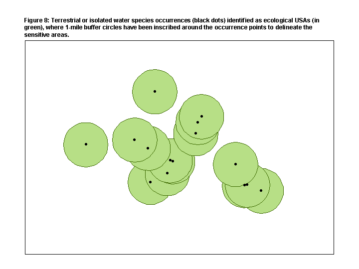
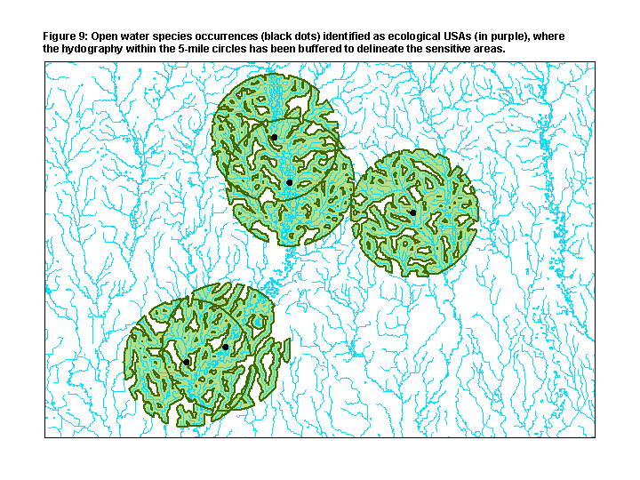
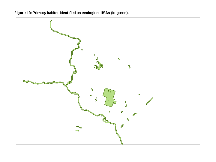
Most biodiversity databases store species occurrences as points, although some additionally map their occurrences as polygons to indicate primary habitat. For species occurrence points, the USA model uses ArcInfo to identify an area of unusual sensitivity (or USA). Terrestrial species or species that occur predominately in, or associated with, isolated or ephemeral water, are inscribed with a 1-mile buffer circle which is employed as the USA boundary. For species that predominately occur in large bodies of water or non-isolated water, a 5-mile buffer circle is inscribed around the occurrence point and all surface water features (lakes, rivers, streams, etc.) within the circle are buffered to a quarter-mile to account for important riparian areas along shorelines and stream banks. This method is identical to the one used to represent surface water USAs. Ecological USAs typically appear as three recognizable patterns: solid circles (terrestrial or isolated water species), brain-like dendritic circles (open water aquatic species), and irregular-shaped polygons (primary habitat mapped by natural heritage programs).
A smaller number of ecological USAs are identified from Western Hemisphere Shorebird Reserve Network (WHSRN) sites, Wetlands of International Importance (Ramsar) sites, and the National Oceanic and Atmospheric Administration (NOAA) Environmental Sensitivity Index (ESI) data for species along the seacoast and major inland lakes. NOAA ESI data characterize estuarine environments and wildlife by their sensitivity to spilled oil. These datasets depict sensitive biological resource data as points (for occurrences) and polygons (for primary habitat). The USA model processes ESI data the same as natural heritage species occurrences, because of their similarities. NOAA ESI data and maps can be obtained for nominal fees through the NOAA Office of Response and Restoration at http://response.restoration.noaa.gov/order/esiindex.html.
Ecological USAs identified from Western Hemisphere Shorebird Reserve Network (WHSRN) sites are areas that contain migratory shorebird concentrations and have been designated a hemispheric reserve, international reserve, or endangered species reserve. To find out more about these designations and U.S. locations of WHSRN sites, see http://www.manomet.org/WHSRN/index.html.
Ecological USAs identified from Ramsar sites are areas that have been designated under The Convention on Wetlands of International Importance Especially as Waterfowl Habitat program. The term "Ramsar" comes from the name of the city where the intergovernmental treaty was signed in 1971, Ramsar, Iran. Ramsar sites are globally critical wetland areas that support migratory waterfowl. More information on these sites and their locations in the U.S. can be found at http://www.ramsar.org/index.html.
Similar to the drinking water USA tables, OPS also developed tables that cross-match each ecological USA with its respective species (or element) occurrence (referenced by a field called EOCODE). The table links an EOCODE to the ECOUNIQUE# field of the USA region attribute table. With the EOCODE, an operator can find out more about the USA’s ecological species or community that could potentially be affected by a pipeline release. This information is valuable not only for integrity management, but also for risk assessment, mitigation, and emergency response efforts. It makes common sense to know what is being protected, since different methods are employed to limit risk or clean up the habitats of a bear or a nesting bird or a mussel.
There is a wealth of useful information inherent in biodiversity databases not taken into account when identifying ecological USAs, due to the lack of consistency or reliability in data input across state natural heritage programs. This information can shed light on important aspects of a USA’s sensitive resource, however, that could limit the potential to affect it. Some characteristics detailed are: the last time the species was seen in the area; whether the species was alive or dead when sited; and the viability of the specimen (i.e. is the occurrence healthy and secure in its current habitat or is the specimen historic in that it was last seen 20 years ago before a subdivision went in?)
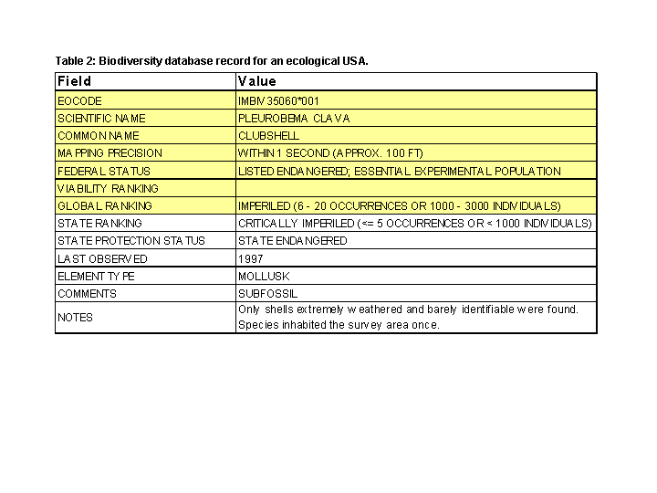
Table 2 lists the record for an ecological USA identified by OPS. The fields shown are typical of the singular data structure subscribed to by all natural heritage programs. USA-pertinent attributes are highlighted in yellow. This record indicates that the species occurrence is an essential experimental population of a federally endangered mollusk that was not able to survive in the area. The subjective commentary tells the story of this particular occurrence. Since this data field is not readily standardized for input into the USA model, it was not considered during the identification process. Thus, the occurrence was assigned USA status. In reality, there is no longer anything to protect in this area, but an operator would never discover this without researching the origins of the USA.
It is important to remember that biodiversity data is by its very nature sensitive information. NatureServe and its member programs take the responsibility of protecting the locations of rare plants, animals, and ecological communities very seriously. Acknowledging the importance of sharing the data with those who can help preserve these critical habitats, NatureServe strives to protect the release of information through data license agreements and ensure continued research by negotiating fees for their members’ data. In order to obtain and use species occurrence data in the ecological USA model, OPS had to purchase the data from NatureServe and sign a data license agreement stating that only operators and certain government agencies would be privy to the ecological USAs and that no species occurrence information could be released by OPS. The upshot of this agreement is that operators wishing to know more about their "could affect" ecological USAs can only receive the resource data through requests to NatureServe or the state natural heritage programs, not through OPS.
With the advent of ecological USAs, their impact on pipeline operators, and the subsequent influx of requests for USA-related species occurrence data, NatureServe has been working hard to establish an overall pricing structure and data request procedure that efficiently provides operators with the information they need for a reasonable price. This organizational effort is challenging, however. Some natural heritage programs fall under state laws that prohibit the release of any species occurrence locations. In addition, state natural heritage programs run the gamut in their internal policies about how to handle data requests, depending on their management’s views and the funding and resources available to them. Some programs prefer to handle all data requests themselves, some grant NatureServe permission to respond to data requests that they consider too large to handle in-house, and others have little or no resources to handle data requests at all. Also compounding NatureServe’s endeavors to standardize the data request procedure is the myriad ways that state natural heritage programs charge for their labor and data. The methods range from state laws prohibiting programs to levy any fee to a price per record charge. Despite these challenges, NatureServe has had considerable success in securing permission to release its members’ data and negotiating reasonable costs. NatureServe is best equipped to handle data requests for large areas of a state or for areas that cross multiple states. For data requests involving "could affect" USAs within a small area, the state natural heritage program is usually the most expedient way to find the information.
HCAs were originally conceived as an approach to complying with the Accountable Pipeline Safety and Partnership Act of 1996 (49 USC 60109). The definition of a high consequence area is founded upon Congressional intent to focus upon environmentally significant areas in the United States that would suffer permanent and long-term damage in the event of a pipeline rupture. OPS has provided a viable source of uniform data delineating these areas and made their locations available to all pipeline operators. It is up to the operators to conduct site-specific risk assessments to ascertain the best preventative measures to protect these important areas. Considering the high cost of integrity management, the time and expense required to research the GIS resource data behind the "could affect" HCAs are negligible compared to the costs of mitigating areas where the environmental resource has been depleted.
The HCA identification process is the culmination of a significant effort in both scope and duration. It is important to pay tribute to dedicated OPS staff, the members and supporters of the American Petroleum Institute (API) USA Working Group, various federal and state agencies, environmental associations, academia, and the technical contractors, Tetra Tech - MFG, Inc, and Research Planning, Inc. for their perseverance and teamwork in the collaborative effort.
Federal Register. 1996. 49 USC 60109.
Federal Register. 2000. 49 CFR Parts 195.
Freeman, B., A. M. Macrander, B. Holton, J. Williams, and S. Zengel. 2001. Using GIS to Identify Unusually Sensitive Areas. The 21st Annual Esri International User Conference Proceedings.
NatureServe Network Overview [Online]. 2001. Available: http://www.natureserve.org/about_nhnoverview.htm. Accessed: July 5, 2002.
NatureServe Overview [Online]. 2001. Available: http://www.natureserve.org/about_natureserveoverview.htm. Accessed: July 5, 2002.
Pettyjohn, W. A., M. Savoka, and D. Self. 1991. Regional Assessment of Aquifer Vulnerability and Sensitivity in the Conterminous United States. U.S. Environmental Protection Agency, Robert S. Kerr Environmental Research Laboratory, Office of Research and Development, EPA/600/2-91/043.
_______. 1994. Geographic Areas Reference Manual. U.S. Department of Commerce, Economics and Statistics Administration, Bureau of the Census.