Ed DeYoung
Building a 911 geofile for emergency Computer Aided Dispatch (CAD) can be a time consuming and tedious process. There are tools and tricks I have learned in building geofiles for three cities that help this process become as accurate and smooth as possible. Available GIS methods to overcome the hurdles in geofile creation will be reviewed.
A geofile is the location information base file for emergency 911 CAD systems. It contains street networks with location information like addresses and street intersections. It also contains information for incident reporting like police and fire reporting districts. A geofile can be in the shapefile format or a vendor's custom format. This paper will look at issues in using GIS to create a geofile, systems for maintenance and potential geofile improvements with GIS technology.
I have ten years of professional GIS experience and have recently built the geofiles for three Southern California cities. All three were based on street blocks that can be represented as a line theme. I have seen a geofile based on a polygon theme and think that it has some advantages over a line based geofile. This paper will only review line based geofile systems.
The basic function of the geofile is to aid the dispatcher in getting the right help to the right place as fast as possible. The geofile is a map with very good address blocks and associated attributes. This is a geographic location task for which GIS is perfectly suited.
A geofile is a logical street address file where address in the most important feature of the file. A geofile has to be able to direct the dispatch and response personnel to the correct block on the correct side of the correct street. It has to know the correct drive in a trailer park and the correct hall in a shopping mall. Since addressing schemes are not perfect and are not always adhered to correctly, the real world address are complicated and a geofile must best represent real world address locations even at the expense of cartographic uniformity.
Commercial street data sets can be used as a starting point in building a geofile, however they are created at a regional or even national scale and do not have local accuracy. In my experience with several commercial street data sets I found roughly half of all street blocks need some modification in one of the name or address attributes. It may seem like more work to build your own street file but if you have GIS personnel you may build a better file that fits your needs and accuracy with little extra work. The decision of choosing a commercial street data set or building one will depend on your information resources, budget and GIS staff.
Other resources that are helpful whether you are building a custom street file or cleaning up a purchased one, are all address sources. Good resources of addresses are the parcel addresses. Address tables can be obtained from the local telephone service provider for all phone service locations and local governments often have address information for utility billing or tax collection. I find these address tables good for checking to make sure all addresses are in the geofile but they do not help in showing the location of addresses. The best resource I have found is a local expert such as the 911-dispatch supervisor or a fire department engineer.
Many geofile requirements will be derived from the 911 CAD system. The shape file format is quite common and is used directly by some vendors. Some require that the street line direction follow the address direction. If this is true, all blocks for a given street need to be aligned in the same direction with attributes matching such as address_left_from on the left side and beginning of the street block. Another thing to check for is between intersection nodes. Some commercial street data sets have many of these, which makes having a continuous address scheme difficult. Geofiles should have full 100 block address ranges such as 200 to 298 that are continuous from block to block and do not overlap.
In contrast to full blocks for geocoding you would want an accurate address range like 200 to 272 where the low address and high address match the actual low and high addresses. This would give the most accurate geocoded location by good approximation along the street. The job of a geofile however, is to direct help to the correct block on the correct side of the street. Full, continuous and non-overlapping address ranges guarantees all possible addresses exist in the right block even if an address is not used.
Along with street name and address information other location attributes are required or desired. Common geographic areas required are city, zip code, census tracts and reporting districts for Fire, Police and other Emergency Responders. Specific maps, beats or a local map grid may be useful to have in the geofile. Map coordinates such as State_Plane or Latitude_Longitude may be required in the geofile attribute table for CAD system use or real time GPS for vehicle location. Free extensions from www.Esri.com like AddXYToTable and similar ones are great for putting the coordinate values in the attribute table.
A very methodic process must be used to create or check the attributes of a geofile. I sort on street name and then step through each block of a street from one end to the other to check the High and Low addresses for right and left sides. This way I can check to make sure address from one block to the next are continuous and do not overlap. Odd/even consistency and high/low flip-flops can easily be spotted in this process. Addresses are the most tedious attributes to verify but are the heart of the geofile.
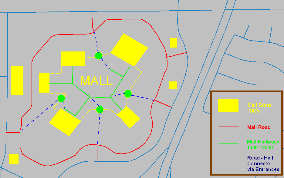
There are many features of a city that do not fit an addressing scheme that converts well into a geofile. Mall complexes may have a large building with several anchor stores and many shops in the mall on many levels with additional buildings and structures in the surrounding parking area with no overall uniform addressing system.
I have used the mall parking lot road to address the anchor stores and parking area buildings that were in the 100s range. The shops in the mall were addressed 1000s on the first floor and 200s on the second floor. I had to add Sears Wing Upper Road, Sears Wing Lower Road, Penney's Wing Upper Road and so on in order to capture all the addresses. I used the mall entrances to link the Mall "Roads" to the parking road and surrounding road network.
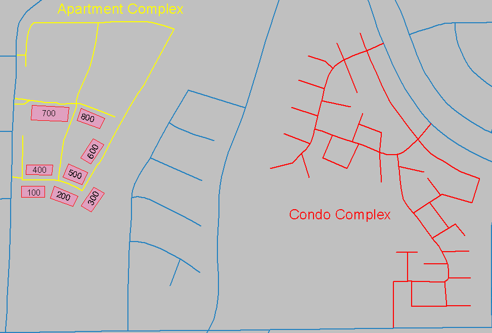
Apartments, Condos and Trailer Parks can also be difficult. The whole complex probably has one address to an external street but private streets are usually named with numbered lots or units. Sometimes the streets and units can be made to fit into a geofile such as the Condo complex shown and sometimes not like the Apartment buildings in the following figure.
Alleys may be references used in a city like 'On Central between Main and the Alley'. Alleys may even be reporting district boundaries, yet in order to have them in a geofile they have to be given a name and address range. I have typically left alleys out of the geofile. They can always be shown on the CAD system map even if they are not used in the geofile. Similarly, railroads may or may not be used but need to be named and addressed if used in the geofile.
Freeways are complex because they do not have traditional addresses or intersections but they need to be in a geofile. I use a directional suffix to distinguish between northbound and southbound lanes. I name the ramps for the streets they access such as '5 Freeway N On Main' as the name with 'Ramp' as the type. Freeways can be addressed to correspond to the mile marker system or some arbitrary system that makes sense to those who will use it. One system can be to accommodate detailed addressing convention and an easy name and address system used through an alias.
Street name aliases are one file that accompanies a geofile. Aliases can be used to capture common names, shorthand names and even common typos. Common places are another table that is used to capture location names such as "Bob's Pizza" or "Bank of Savings" so the name can be input by a 911 operator and the address will be given. Target addresses are put in another table to identify locations that need a special emergency response such as a ladder truck for a high rise building.
Once all the effort has been put into creating a good geofile it is worth too much to let it become outdated. Continual maintenance is needed but challenging to keep on top of. I propose setting up an update system that is as automatic as possible with specific update responsibilities given to specific people.
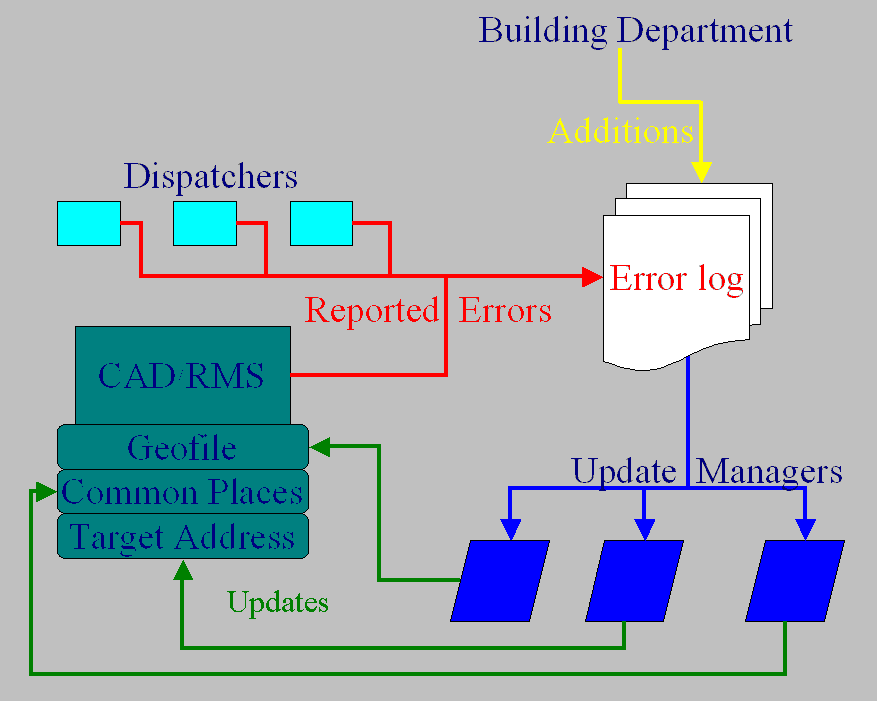
I would give the dispatchers a web or email tool to be able to send a noticed error or confusing system response to a geofile update log. All addresses called in that were not in the geofile would also be automatically sent to the geofile update log for analysis. Someone in the city building department would be tasked to send new developed streets and new addresses to the geofile update log. One person would be tasked to monitor the geofile update log and other resources for Common place changes or additions. A second person would be tasked with adding and updating the Target addresses. A third person would oversee the Alias file changes and additions. A fourth person with GIS skills would be in charge of updating the geofile. A final person would be tasked to manage the geofile update process and would verify that the geofile update log was being addressed in a correct and timely manner and that each person was carrying out their portion of responsibility.
Creating a geofile for a 911 CAD system takes a lot of effort however GIS seems as if it was made for this task. The geofile must be created to accurately represent the location all addresses as they exist. It takes creativity to make some features fit in the geofile. Once a functional geofile is built it is well worth the effort to keep it maintained for long and accurate use.
Ed DeYoung
GIS Consultant, GLOBAL InfoSci
www.GLOBALInfoSci.com