Abstract: Maintaining and restoring the conservation integrity of large areas requires identifying landscape connections that can serve as corridors for animal movements. The Southern Appalachian Forest Coalition is working to establish a networked system of conservation areas in the Southern Appalachian region. A methodology will be presented that was used to determine potential landscape connections between remaining unroaded areas. The study, which used ArcGIS and Least Cost Path analysis in Grid or Spacial Analyst, accounts for the biological effects of different classes of roads and categorizes three levels of connectivity. This methodology should have application for conservation efforts in other regions.
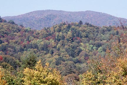
Fig 1: Connections Between Unroaded Habitat is an Important Regional Resource
In order for landscape conservation areas to function as a regional conservation network, there must be ecological connectivity between the areas. This requirement is difficult to fulfill in a region that has been roaded and developed as much as the Southern Appalachians. However, there currently remain many viable connections across the landscape, and in the long term the potential for connectivity is great.
Connectivity between unroaded areas was assessed for its value to large, wide-ranging species, using parameters that specifically suit black bear. However, the analysis also applies generally to other wide-ranging predators that need large territories and depend on connections across the landscape.
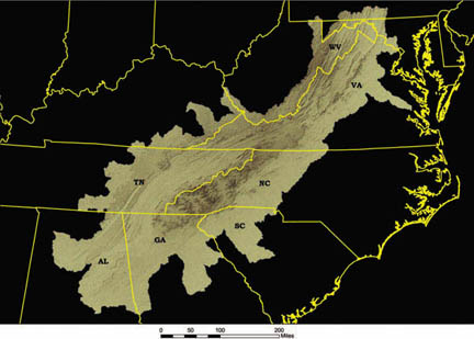
Fig 2: The Southern Appalachian Region
The Southern Appalachian region encompasses more than 70 million acres in the mountainous portions of eight states, from Alabama to southrn Pennsylvaniua. The features of this region have been depicted in many ways. We have chosen to use a combination of ecoregion divisions and watershed boundaries to delineate and describe the important features of the region.
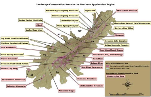
Fig 3 Landscape Conservation Areas in the Southern Appalachian Region
Establishing a network of landscape conservation areas in a developed region like the Southern Appalachians depends on protecting and restoring conservation building blocks within core areas of habitat and linking these core areas together. The important first step is to ensure the integrity of the existing and restorable large conservation areas of the region.
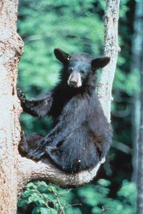
Fig 4: Juvenile Black Bear (Bill Lea, USFS)
Black bears have recovered from near extirpation to reach their healthiest populations in the Southern Appalachians in many decades. Most researchers attribute the bears’ success to the maturing of the surrounding forests and the designated breeding zones and other remote areas that function, by design or default, as biological refuges.
However, even in their success, black bears illustrate the incomplete ecological recovery that characterizes the Southern Appalachians today. Although bear populations have improved, they are confined to islands of suitable territory that are surrounded by human populations and activities.
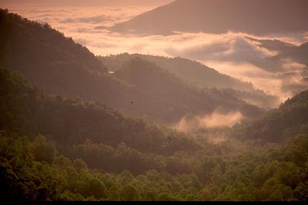
Fig 5 Linked Core Landscapes Can Fill Many of the Roles of Intact Landscapes (Bill Lea, USFS)
When the natural landscape is intact, individuals from one population are free to move over a wide area to interbreed. This freedom allows species such as bear to have a continuous population.
Currently, in the Southern Appalachians, bear and many other species are increasingly isolated into discreet populations separated by inhospitable habitat. These populations are therefore genetically limited and subject to perturbations, including extinction. However, if these populations can be linked by occasional dispersal, they could be considered part of a larger "metapopulation" (McCullough 1996). Such metapopulations are generally more stable than isolated populations because they produce individuals that are more resilient to disease and genetic deterioration.
Metapopulation dynamics, which depend on the ability of individuals to travel between different population areas, prevent inbreeding and provide a mechanism for repopulation when one population suffers a catastrophic decline. Continuous population dynamics are best, but core areas large enough for breeding populations of wildlife and connections sufficient to provide for healthy metapopulation dynamics should be considered essential.
Bears are a good indicator for how well habitat and landscape connectivity is provided for other species; if it is not possible for bears to move across the landscape, it is likely that other terrestrial species will be isolated as well. If corridors exist that allow bear to move from one core area of habitat to another, other species are likely to be able to move along the same corridor. Providing for bear thus creates an "umbrella" that provides for many other species.
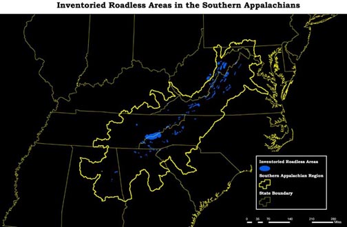
Fig 6: Significant tracts of national forest lands remain relatively free of roads. Approximately 487,000 acres, or 10 percent, of the national forest in the Southern Appalachians meet strict U.S. Forest Service criteria as roadless area.
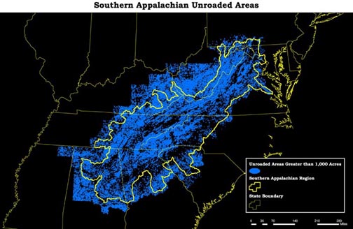
Fig 7: Unroaded Areas Make up a Much Greater Portion of the Region than Inventoried "Roadless Areas"
Since roads are the conduits for both direct and indirect fragmentation, the absence of roads is one of the primary prerequisites for landscape conservation areas. In order to evaluate the conditions of the region’s conservation areas and to evaluate the potential for connectivity between them, SAFC identified and analyzed remaining unroaded areas in the Southern Appalachians.
During this process, SAFC verified that the Forest Service’s roadless inventory failed to identify many unroaded areas relevant to ecological functioning. The Forest Service inventory, while identifying many important areas, also omits important areas that do not satisfy the agency’s stringent roadless criteria.
In addition, the agency’s inventory of roadless areas was confined to public lands. In fact, many unroaded areas that do not satisfy official size, configuration, and ownership constraints still provide significant habitat and ecological connectivity. Even the smallest such areas can serve as vital "stepping stones" that provide connections between larger areas.
SAFC adapted the methodology used by the Pacific Biodiversity Institute (Morrison 2001), identifying unroaded areas greater than 1,000 acres throughout the Southern Appalachians.
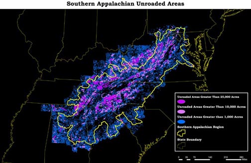
Fig 8: Unroaded Areas were Classified into Size Classes
Unroaded Areas were classified into size classes of Greater Than 25,000 acres; Between 25,000 acres and 10,000 acres and Between 10,000 acres and 1,000 acres.
These areas were categorized by size on the conservation biology principle that larger areas generally provide greater ecological value than smaller areas. The areas ranged in size from the 1,000-acre minimum to more than 272,000 acres, with their distribution heavily weighted to the smaller sizes.
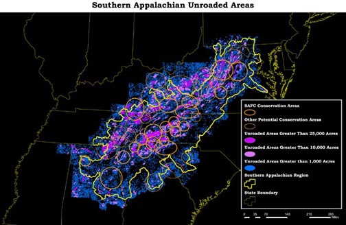
Fig 9: The Largest Unroaded Areas Generally Fell Within the Identified Landscape Conservation Areas.
This unroaded area analysis verifies that landscape conservation areas identified by SAFC contain some of the most significant clusters of unroaded areas, particularly larger unroaded areas. The broad outline of additional landscape conservation areas can also be identified in the concentrations of remaining unroaded areas. These additional prominent clusters of unroaded areas prompted the identification of supplementary landscape areas.
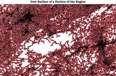
Fig 10: Cost surface based on distance from road.
The assessment used a weighted distance in which proximity to roads was considered to cause greater resistance to animal movement. A GIS "least cost path analysis" modeled the routes that would incur the least biological cost for bear movements. A cost surface was generated with values that increase as distance to roads increase. Higher use and interstate level roads received the highest value with low use dirt roads receiving the lowest value.
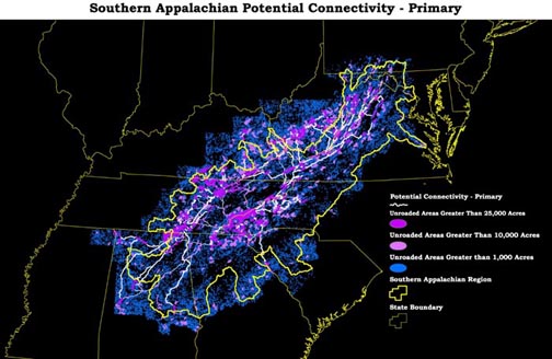
Fig 11: Primary Connectivity
Larger unroaded blocks (greater than 25,000 acres) were assumed to provide primary habitat and were considered to be "source areas" for animals. Primary connectivity for movement was derived between the unroaded areas greater than 25,000 acres by matching closest large areas and conducting LCP analysis between them. Note, however that the smaller unroaded areas serve as stepping stones for this primary connectivity.
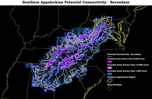
Fig 12: Secondary Connectivity
Connections between the largest roadless areas and a second tier of unroaded areas between 10,000 acres and 25,000 acres were considered secondary connectivity.
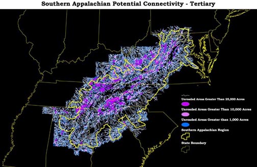
Fig 13: Tertiary Connectivity
Tertiary connectivy between the smallest unroaded areas and the largest unroaded areas gave results that frequently were obviously false positives for potential connectivity. This level of connectivy was discarded. However, refinements in evaluating the quality of potential connectivity might make this level of analysis useful.
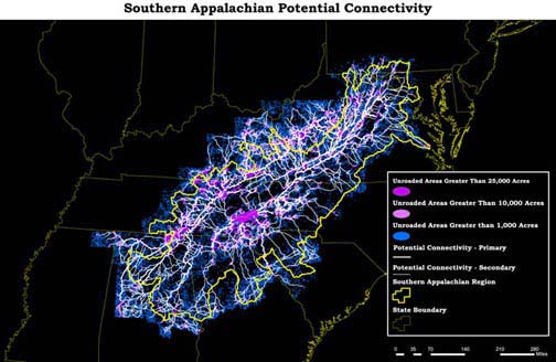
Fig 14: Potential Connectivity for Bear Movement
The analysis showed that even small blocks of unroaded wildlands could perform the essential ecological function of linking larger unroaded areas together in a regional network.
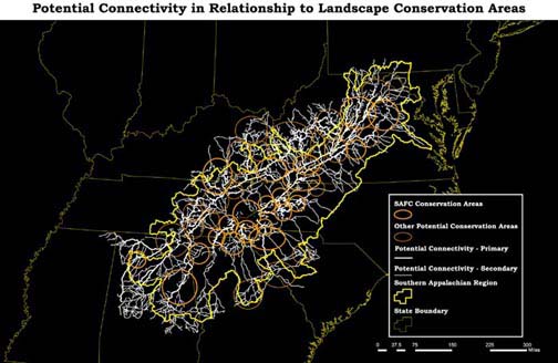
Fig 15: The connectivity analysis helps to visualize potential connectivity between landscape conservation areas
The condition of these landscape connections varies. Some currently function as landscape connections; some could function with key conservation initiatives to improve their conditions; others would require extensive conservation groundwork; including the establishment of corridors across highways. In most cases considerable conservation work, including conservation acquisitions, easements, and road engineering will be required to secure the integrity of the connections into the future.
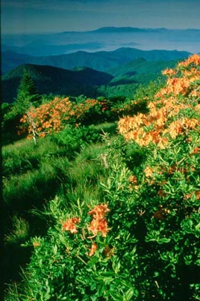
Fig 17: Unroaded Blocks Should be Maintained and Expanded Whenever Possible (Kevin Adams)
There are several implications of the unroaded area identification and connectivity analysis.
In order to maintain and enhance the ecological performance of conservation areas on a regional basis, unroaded blocks should be maintained and even expanded whenever possible.
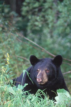
Fig 16: Adult Black Bear (Bill Lea, USFS)
It has been suggested that wildlife biologists could create "virtual" metapopulations on a case-by-case basis, physically transporting individuals of a species such as bear from one breeding area to another. This is clearly less effective or desirable than a well-linked system of landscape-scale habitats. The tools and materials exist to create a truly functional ecological landscape that sustains itself the way it has for millennia.
Conservation protection, acquisition,and easement priorities should be established, taking regional connectivity into account. The connectivity between conservation areas should be strengthened as well by mitigating the fragmenting effects of major roads through road engineering that allows freer passage for wildlife. Landscape and regional analysis to retain and augment wildlife linkages should become a regular part of conservation planning in the future.
Arrhenius, O. 1921. "Species and Area."Journal of Ecology 9:95-99
Beier, P. 1993. "Determining minimum habitat areas and habitat corridors for cougars." Conservation Biology 7:94-108.
Frankel, O. H. and M. E. Soulé. 1981.Conservation and Evolution. Cambridge, UK: Cambridge University Press.
Frome, M. 1989. Conscience of a Conservationist.Knoxville, TN: U.T. Press.
Haney, J.C., M. Wilbert, C. DeGrood, D.S.Lee, and J. Thompson. 1999. "Gauging the Ecological Capacity of Southern Appalachian Reserves: Does Wilderness Matter?" In Cole, D.N., S.F McCool, eds. Wilderness Science in a Time of Change. Proc. RMRS-P-000. US Department of Agriculture. Ogden, Utah. 23 pp.
McCullough, D. R. 1996. "Introduction." In McCullough, D. R. Metapopulations and Wildlife Conservation. Washington, DC: Island Press pp. 1-10.
Margules, C.R., A.O. Nichols, and R.L. Pressey. 1988. "Selecting Networks of Reserves to Maximize Biological Diversity." Biological Conservation 43: 63-76.
Mills, L.S., M.E. Soulé, and D.F. Doak. 1993. "The History and Current Status of the Keystone Species Concept." Bioscience 43:219-224.
Morrison, P. 2001. Personal communication from Peter Morrison, Pacific Biodiversity Institute, Winthrop, WA to Hugh Irwin, Southern Appalachian Forest Coalition, Asheville, NC.
Newmark, W. D. 1987. "A Land-bridge Island Perspective on Mammalian Extinctions in Western North American Parks. Nature 325:430-432.
Newmark, W.D. 1995. "Extinctions of Mammal Populations in Western North American National Parks. Conservation Biology 9:512-526.
Noss, R. F. and A. Y. Cooperrider. 1994. Saving Nature’s Legacy: Protecting and Restoring Biodiversity. Washington, DC: Island Pres
SAMAB (Southern Appalachian Man and the Biosphere). 1996a. The Southern Appalachian Assessment Terrestrial Technical Report. 5 volumes. U.S. Department of Agriculture, Forest Service, Southern Region, Atlanta, GA.
----------. 1996b. The Southern Appalachian Assessment Terrestrial Technical Report. Vol. 5. U.S. Department of Agriculture, Forest Service, Southern Region, Atlanta, GA.
Soulé, M. and R.F Noss. 1998. "Rewilding and Biodiversity as Complementary Goals for Continental Conservation." Wild Earth (Fall): 19-28.
Terborgh, J., J.A. Estes, P. Paquet, K. Ralls, D. Boyd, B. Miller, and R. Noss. 1999. "The Role of Top Carnivores in Regulating Terrestrial Ecosystems." In Soulé, M. and J.
Terborgh, Continental Conservation: Design and Management Principles for Long-term, Regional Conservation Networks. Covelo, CA and Washington, DC: Island Press