Being responsible for the integration of GIS as a key-technology within the agricultural departments of Northrine-Westfalia (NRW, Germany), the Institute for Agricultural and Forestal Informatics (afi) at the University of Münster is convinced that a.) the GIS-establishing-process itself and b.) the idea of refining geodata through geo-services to bring the business-aspect to the agricultural GIS-domain are both highly depending on the realization of well working geodatainfrastructures, based on international standards like OGC or ISO. Working closely together with the Institute for Geoinformatics (IfGI) at the University of Münster (partner of the Spatial Data Infrastructure-initiative of NRW, GDI-NRW), backgrounds, motivation, concepts and applications will be presented.
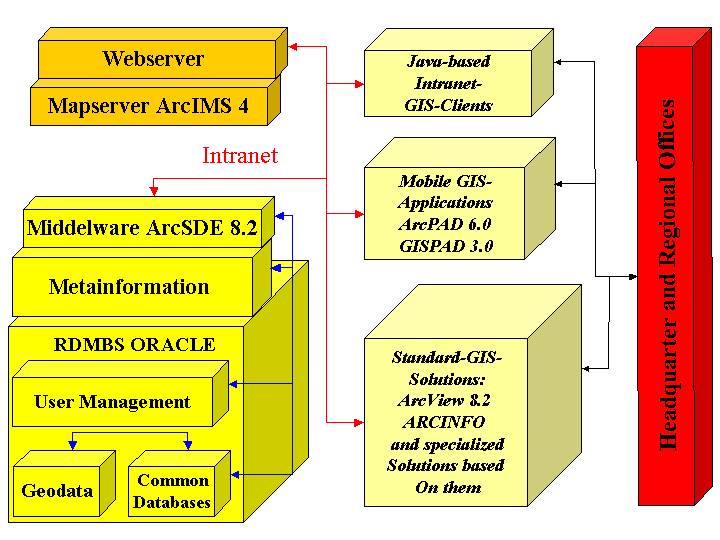
Founded in 1990, the current mission of the Institute for Agricultural and Forestal Informatics (afi) at the University of Münster in Germany is the integration of GeoInformation(GI)-technology as a turnkey-technology within the existing IT-structures of the agricultural and forestal GIS-application domains in general, but especially within the state of Northrine-Westfalia (NRW). Based on an extensive GIS-integration study done by the afi in 1997, the departments of agriculture within NRW are already possessing geodataservers as the central aspect of their integration philosophy. Both, a massive amount of basic geodata (e.g. topographic maps or aerial photographies) and specific geodata (e.g. field-unit- or soil-sample-layers) for the whole state are already stored or are intended to be stored and managed on these geodataservers. Central views to this geodata are delivered by mapservers to all employees via the intranet of the departments of agriculture. Moreover many specific GIS-applications have access to the geodataservers as well, like tools for erosion- or watershed management and of course tools for the classic agricultural consulting business, which is still the main task of the departments of agriculture.
Seen from the GI-technology point of view, agriculture is intensively bounded to space. The agricultural domain is permanently raising spatial questions, which have to be answered by the departments for agriculture, their main clientele itself, the farmers or companies from the agribusiness-section. The quality of these answers is highly depending on fast access to reliable and up-to-date (geo-)data and geo-services, offering functions to answer these questions using this data. The afi is deeply convinced that the core-aspect to a successful GIS-based agribusiness will be well-working geodatainfrastructures and geo-services operating on them, based on international standards like specifications from the OpenGIS Consortium (OGC) and the International Organization for Standardization (ISO).
As suggested in the introductional chapter, the departments of agriculture in NRW have begun to integrate GI-technology as a new core-technology into their already existing IT-structures. They have established basic technological components like geodata- and mapservers and in front of this background they have made some very important experiences with regard to the question on which parameters this integration-process is depending. One experience is that organizations like the departments of agriculture can invest as much money as possible into GI-technology, but as long as they cannot gurantee the correctness and the up-to-date-status of the geodata used by this technology the user will not really accept or in the worst case reject the technology. This aspect is in particular concerning "external", basic geodata, like topographic maps, aerial photographies, boundaries of nature-protection areas, cadastral units and many more. Though this geodata is stored and managed on the central geodataservers of the departments and can be accessed by literally every employee with no problems via intranet-clients, it cannot be guaranteed that at the time the data is used it is up-to-date, because at that moment the geodata is not coming from it original source (e.g. the aerial photographies used by the departments have their origins at the Land Surveying Office of NRW). But there is actually no geodataserver at this land surveying office with which the departments geodataservers could communicate and easily exchange geodata. So, only from time to time the geodatabases at the departments are updated more or less manually. Geodatainfrastructures in terms of communicating networknodes would solve this problem by offering geodata through geo-services which are operating on geodata left at its origin.
Concerning specialized geodata of the departments, the departments are fully aware of the fact that the building of datasets like a field-unit-layer for the whole state of NRW is extremely cost extensive and that they are forced to bring this valuable item to market. Until now quiet umimagenable for admistrative units like the agricultural departments, the idea to become a service provider slowly establishes within these institutions. In other words: specialized data like field-unit-data cannot longer only be used within the departments but must be offered through services via internet to a wider circle of users in terms of refining the data to cover the invested money.
Recently the departments of agriculture in NRW are on the way to a state-wide field-unit-cover, motivated by new requirements to the integrated administration and control system for certain community aid schemes of the European Community (European Council regulation No. 1593/2000). This system describes how farmers apply for financial support for certain activities on their fields and how the responsible institutions (in Germany mainly the departments of agriculture within the single states) control the farmers applications. The renewed regulation requires the intensive use and integration of GI-technology and at least some basic geodata like aerial photographies within this system from the beginning of the year 2005 on. This regulation is seen as "the" driving force with regard to the extensive use of GI-technology in the agricultural domain in Germany, because one of the main tasks of the agricultural administration is the correct implementation of this regulation on which many farmers existence depend and so GI-technology will find its way to this central field of application within the agricultural domain.
However: one result of the implementation of this new regulation will be a state-wide field-unit-cadastre created by the agricultural departments for the farmers application-purposes. It is assumed that one of the most important aspects of bringing GI-technology to agriculture is the existence of such a dataset. From 2005 on it will exist in NRW and the decision has been made that this dataset will be used for other puposes, geo-services as well, than just the application-purpose. A really successful use of this dataset can only be guaranteed through geo-services within a geodatainfrastructure, because attractive geoservices for farmers always need several data-sources, which are apart of the specialized dataset field-unit are not under control of the agricultural departments (e.g. soil-maps coming from the Geological Service in NRW). To give the user of these geo-services the guarantee that the used data is up-to-date, the applications must operate on individual network nodes, which are usually geodataservers.
Recapitulating : there is a clear and present need to setup geodatainfrastructures with regard to the establishment of agricultural geo-business applications. The basic requirements to geodatainfrastructures are the easy, fast, secure, cost-efficient and reliable access to up-to-date geodata and geo-services working on this data.
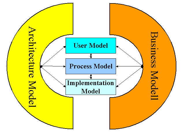
Concerning the establishment of agricultural geo-business applications, the geodatainfrastructure initiative of NRW will play an import role. This statewide initiative has been started at the beginning of the year 2000. The main goal of the initiative is the stimulation and the setup of the geoinformation market within Northrine-Westfalia. A multidisciplinary team is operating on the networking of the value-added chains of users, service-providers, data- and infrastructure-providers. It is developed on the background of distributed, interoperable system-standards (OGC, ISO) and open architectures like the internet. Geodata is not longer seen as only simple data but as an information product, which must be brought to market. GDI NRW has been scientifically attended by the IfGI, University of Münster, which has for example developed and described the first so called reference model for GDI NRW (in general: description of goals and content of the GDI NRW). It recently consist of 5 components describing all models involved within the setup-process of the GDI NRW.
Under consideration of this reference model, several GI-services have already been published within testbed 1 of the GDI NRW. This first testbed is seen as the cristallyzation-point of the GDI NRW.
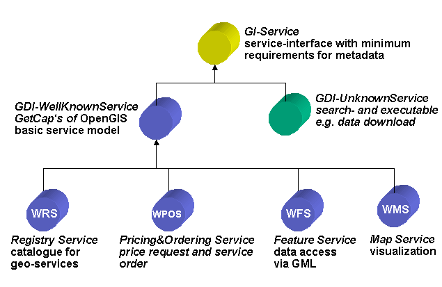
Among these services has been for example TerraSeek, an OGC-conformable Catalog Service of the con terra inc., Münster, Germany, which is a so called "spin-off-inc." of the IfGI. This geo-service allows the inquiry of and access to metadata describing GI-products. It is web-based and allows the visualization of the inquiry-results and moreover the registration of metadata concerning geodata and geoservices. TerraSeek played an important role as a Web Registry Service within the framework of an subtestbed of testbed 1 GDI NRW, namely the subtestbed for the department of forestry in Westfalen-Lippe, NRW. Three GI-services were registered and could be accessed through TerraSeek:
a cascading OpenGIS Web Map Server,The OpenGIS Web Map Server was positioned at the Institute for Geoinformatics and had access to two further remote Web Map Servers and the Web Feature Server. This Web Map Server received maprequests through a Web Map Client. It could be shown that geodata from different sources in terms of GI-services can easily be integrated in one Web Map Server and delivered by an accompaining Web Map Client when following standardized specifications.
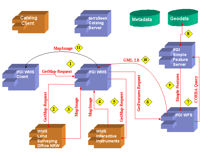
The realization of this subtestbed was stimulated by a study of the IfGI by order of the Department of Forestry of Westfalen-Lippe, concerning a cooperative geodatainfrastructure between this department and the Department of Agriculture for the same region. One output of this study was that both departments are more or less using the same basic geodata (especially aerial photographies and topographic maps). This basic geodata is actually stored completey twice: once in the Department of Forestry and once in the Department of Agriculture of Westfalen-Lippe, though both departments are in one building (-> high data-redundance -> high administrative costs). Moreover it was recognized that both institutions mutually have a markedly interest in the specialized geodata (field-units, forest-areas) of the other department.
With the results of this accompanying subtestbed it became clear that the status quo of the GDI NRW already offers solutions with regard to the question of how to manage the permanent and thus up-to-date access to basic geodata (in this case coming from and left at the Land Surveying Office NRW) and its combination with other specialized data (for example coming from the departments of agriculture and forestry). And the key to this insight is the basis of GDI NRW: the interoperability of data and functionality.
As a sidekick of this successfully realized subtestbed, a special interest group (SIG) agriculture and forestry is on the way to be founded within the framework of GDI NRW. Generally this application-field is seen as a worthwhile new business field for the idea of distributing, marketing and refining already existing geodata through geo-services. This development, the founding of new SIGs in general and the detecting of new business fields, is a declared aim for testbed 2 of GDI NRW. Another goal for testbed 2 is the continuing development of Web Pricing and Ordering Services, which of course will be of importance for this new business field as well. Though in this chapter until now only use-cases from the administration-to-administration domain have been discussed, where especially pricing-aspects may not play such a great role, the "real" business use-cases are highly depending on such services. Thus the next chapter will evaluate at least some further possible business fields with regard to future agricultural geo-business applications in front of the background of GDI NRW.
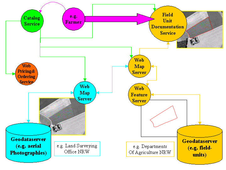
As emphazised in the first chapter, one of the core aspects when talking about the realization of agricultural geo-business applications will be the access to a high-quality field-unit cadastre, which will be for example generated for the whole state of NRW approximately within the next two years by the responsible departments based on their approaches concerning the demands coming from European Regulation No. 1593/2000. So, one of the main, central geodata sources for the agricultural business applications will be this cadastre. It could be offered by a OGC-conformable Web Feature Server which has access to the geodataserver of the corresponding departments. This geodata could be combined with e.g. aerial photographies coming from a Web Map Server positioned at the land survey office of (in this case) NRW, which is the primary source of this data (the geodata would be left at its origin, which would lead to a greater probability that the data is up-to-date). The data of these services would be brought together within a Web Map Client, which would be registrated by a WebRegistryService like TerraSeek. Possible clients like farmers could search for such a service via this registry service and navigate to their area of interest. The payment modalities would be organized through Web Pricing and Ordering Services. It can be assumed that such a field-unit-service in terms of one possible agricultural geo-business-application within GDI NRW will be realized very soon, because this kind of application reflects one of the core-demands of farmers to GI-technology and one demand to the farmers themselves, namely the sustainable documentation of their fields-units in general.
Anyway, the architecture of a geodatainfrastructure like GDI NRW and its basic idea would allow other geodata- or geo-service-providers to connect their data and services to this infrastructure as long as their input to the infrastructure will follow the required standards (e.g. OGC and ISO). Presuming that the common data- and service-providers (public, administrative as private, commercial) will enjoy this initiative, an incredible amount of possible future use-cases could become reality in terms of a real agricultural geo-business-perspective. And one fact will be of crucial importance regarding the commercialization of this approach: namely the easy-to-use aspect (demand) of such geo-services within a geodatainfrastructure for every user, especially the main enduser, the farmer. The offered services will overcome one serious disadvantage concerning the recent situation of the agricultural geo-business: the unmanageable variety of products, their inherent, incompatible (geo-)data-formats and thus uneasy-to-use-status. Nearly every software-user (not only the ones the geo-business is looking for) is not interested in software- or (geo-)data-specific aspects: they simply want answers to their spatial questions and most of them like to get these answers through a service. And that's exactly what geodatainfrastructures offer: simple solutions to complex answers by a well-working service-infrastructure.
Even topics like precision farming (rather a neglected subject in german agricultural daily practice until now) are said to be revitalized through initiatives like GDI NRW, because standardized services within this field could overcome one basic problem in this application field, namely the unproblematic seamless reunion of all necessary geodata for this extremely complex field of interest. It's a good example for the idea of public private partnership within geodatainfrastructures, because on the one hand geodata from public organizations like the Geological Survey NRW (e.g. soil maps) or the Land Surveying Office NRW (e.g. digital elevation model) and private (geo-)data like field unit maps from the concerned farmer plus harvest-result maps of a commercial harvest-machinery provider would be used by one geo-service "precision farming".
Geodatainfrastructures certainly have the potential to become a key-factor for the agricultural geo-business, because:
lots and lots of geodata, GI-technology and ideas how to use them within the agricultural domain are already existing (and of course are used to a certain degree in daily practial work), but to bring the full potential of the recent situation to market, two main paradigm-changes must take place:
geodata cannot longer be seen as just data but must be accepted as a real product (refined and brought to the target-clientele by corresponding geo-services) and
geo-business can only start when all concerned parties (public and private) perceive and are convinced of that no longer stand-alone and proprietary systems are the answer to a sustainable geo-business-future,
but flexible, interoperable service-infrastructures, offering all the freedom to service-providers and their clientele with regard to their demands. Both claims are central aspects of geodatainfrastructures.
There is no doubt that many GI-problems can be solved by using recent technological approaches, but as soon as the GI-community is talking about extensive geo-business and reaching the masses, there will be no other road to success than the road to geodatainfrastructures.
Institute for Geoinformatics, University of Münster, Germany
Center for Geoinformation, Dortmund, Germany
GeoDataInfrastructure Northrine-Westfalia (GDI NRW), (pages at the University of Münster), Germany
Interministerial Committee for Geoinformation, Frankfurt am Main, Germany
Olaf Nölle
Global GIS-Project-Management
Institute for Agricultural and Forestal Informatics
University of Münster
Robert-Kochstrasse No. 26-28
48149 Münster
Germany Tel.: 0049 (0) 251 - 83 -39767
Tel.: 0049 (0) 251 - 83 -39763
EMail: nolleo@ifgi.uni-muenster.de