Jeppesen, the leading supplier of aeronautical navigation data and charts, now produces elevation databases for the aviation industry. Recent FAA regulations mandate that all aircraft carrying six or more passengers be equipped with Terrain Awareness Warning Systems (TAWS) by 2005. TAWS terrain databases must meet critical data quality standards due to their role in accident avoidance. Jeppesen produces high-quality TAWS databases by employing Workstation ArcInfo with GRID and TIN, ArcGIS, and ArcView with Spatial Analyst to generate, validate, document, and distribute these databases. An overview of TAWS and the Jeppesen database production process will be presented in depth.
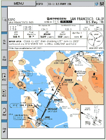
Jeppesen, headquartered in Englewood, Colorado, has been producing aeronautical information including navigational charts, for civil aviation for more than 60 years. Captain Elrey B. Jeppesen, the company's founder, flew airmail delivery before the days of published aeronautical charts. With no way to know the terrain, flying and landing in poor visibility was risky. Capt. Jeppesen drew his own charts, and when other pilots learned of them, business rapidly expanded. Today, Jeppesen produces visual and instrument charts and other types of navigational and planning information, used by major airlines to private pilots worldwide.
Over the years, computerization has made it possible to produce, and for on-board computers to use, new types of aeronautical information. Jeppesen has long utilized both CAD and GIS systems to produce electronic charts and navigation data. Now, in response to flight safety concerns about terrain-related accidents, Jeppesen produces terrain databases for newly mandated Terrain Awareness and Warning Systems (TAWS).
In the last decade, advances in terrain mapping technology have made possible the kind of databases that could give earlier warning of impending flight into terrain. National Transportation and Safety Board (NTSB) investigations into several additional CFIT accidents resulted in recommendations and a final FAA ruling on March 22, 2000. The ruling stated that all turbine-powered aircraft registered in the United States and having 6 or more passenger seats, be equipped with Terrain Awareness Warning Systems (more modern and enhanced versions of GPWS) within 5 years. In fact, all such aircraft rolling off assembly lines after March 29, 2002 must be TAWS-equipped at the time of production.
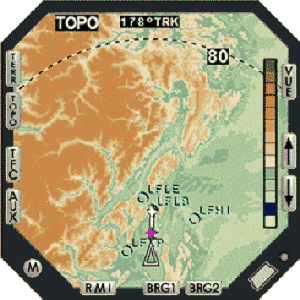
TAWS are forward-looking systems that compare geographical location of the aircraft with the terrain elevation and vertical obstacles within a given search volume of the flight line. They are required to issue various aural and visual alerts and warnings based on conditions such as excessive rate of descent or altitude loss and excessive rate of closure into terrain. They depend upon terrain elevation databases that are loaded into the avionics computer on-board the aircraft, as well as other detection equipment. These databases must be produced under strict quality control standards.
The Jeppesen Terrain Database is developed specifically to meet requirements of individual avionics manufacturers who build TAWS systems. They in turn must meet the requirements outlined in the FAA Technical Standard Order (TSO-C151a) on "Terrain Awareness and Warning Systems." That TSO recommends certain gridding resolution of terrain data, and requires that the data must have been processed to meet DO-200A standards. The Jeppesen Terrain Database has undergone rigorous development and scrutiny in order to meet the TSO and DO-200A standards.
Jeppesen's Database consists of a worldwide set of gridded elevation values standardized to 30-arcsecond (30as, or approximately 1 kilometer) spatial resolution, also known as post spacing. As will be described below, data have been resampled from the original source data to capture the maximum elevation value at each post. Data are registered to geographic coordinates and to the WGS84 datum, and coordinates are stored in units of decimal seconds. Elevation values are stored in either meters or feet.
The database is developed using two main sources of elevation data: the USGS National Elevation Dataset (NED) (1as, or 30 meters), and the NOAA Global Land One-Kilometer Base Elevation (GLOBE) dataset (30 as). The GLOBE dataset was developed from 18 separate regional elevation databases, and it contains extensive metadata useful in providing traceability. Other data sources which may be used as needed include NIMA DTED Level 0 (30as), USGS GTOPO30 (30as), and other localized higher-resolution data as available.
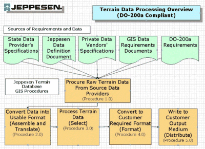
Jeppesen's GIS processing starts with analysis of requirements of TAWS systems, and incorporates analysis of available source data and ArcInfo processing methods. The processing is grouped into five major steps, called "procedures" in DO-200A terminology. These five procedures are discussed below.
Elevation values are stored in floating-point meters. If sea level values are coded as "0" from the source, they must be converted to -500m to distinguish them from legitimate 0-meter elevations on land. This involves constructing binary "land vs. ocean" grids, then comparing the elevation grids with them to determine true ocean-surface grid cells and assign the proper sea-level value.
Visual checks and descriptive statistics are then run on the grids to look for spikes, pits, or other anomalous elevation values. Since DO-200A standards prohibit aeronautical data processors like Jeppesen from changing original source data values, anomalies must be reported to the source provider, who then must make the corrections and deliver new versions to Jeppesen. Once the files are checked and transformed they are moved into a production directory for further processing.
The results of this process are NED and GLOBE grids resampled and interpolated into maximum elevation grids at 3, 6, 15 and 30-arc-second post spacing, organized into 1° x 1° tiles. These maximum elevation grids are now merged together into 5° x 5° tiles, where GLOBE-derived and NED-derived data are kept separate.
The final step is to merge the GLOBE-derived with the NED-derived data into a continuous worldwide database. For this process, the NED grids are considered the primary grids, and the GLOBE grids are used to fill in the remainder of any 5° x 5° tiles not covered by NED. This usually involves using GLOBE data to fill in open ocean areas not covered by NED. To accomplish this, the MERGE command is constructed such that the GLOBE-based dataset is the last file input, because the last file has the least priority in the MERGE algorithm. The result is that wherever NED-based data are missing in a tile, GLOBE-based data are filled in. Output grids include merged 3, 6, 15 and 30-as grids, which are further processed according to customer specifications.
Table 1. Customer Specifications for Jeppesen Terrain Data Specification
|
Specification |
Typical Options |
|
post-spacing |
15as or 30as |
|
tile size |
1° x 1° or 5° x 5° |
|
elevation value format |
integer or floating-point |
|
elevation units |
feet or meters |
|
sea-level value |
-500 or -9999 |
|
NODATA value (there should be none) |
-9999 or -32767 |
|
output file format |
USGS-DEM, USGS-SDTS, IEEE-binary or ASCII, and BIL image format |
Customer-formatted data are stored in a client-specific directory on the system, in preparation for writing to the delivery medium. Metadata files are produced and delivered along with the terrain data, in XML format.
Quality control of the Jeppesen Terrain Database is an ongoing process throughout the production of the data. There are many steps where the data are either visually checked, or values are compared with known surveyed elevations, or statistical checks are run. Errors that are easy to detect are shown in the figure, below.
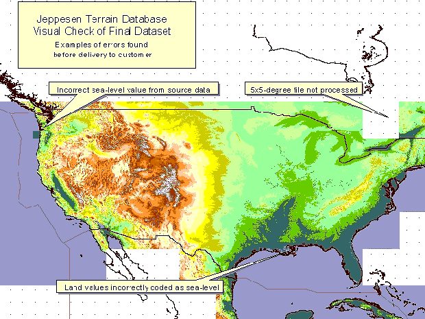
The three errors shown in this figure include incorrect values existing in the source data, missing the processing of an individual 5° x 5° tile, and incorrect coding of elevations on land. When these errors are found, the GIS team reviews the procedures and examines individual AMLs to find the source of the error. Any source-data errors are reported back to the originating agency for future correction. Such anomalies, if they cannot be rectified by the source agency before delivery to the customer, are delivered as-is with full documentation for the customer. AML processing steps causing any errors are corrected, and again reviewed by the GIS team. Data are re-processed, and inspected once again before delivery.
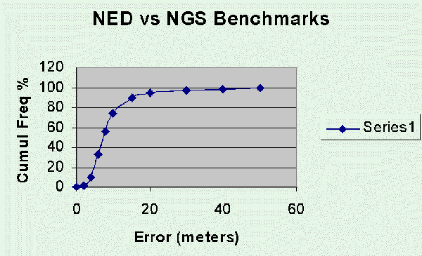
The GIS team can run more rigorous testing of the data when high-quality ground survey data can be obtained. This is the case for the United States proper, where National Geodetic Survey (NGS) control benchmarks are obtained. These independent sources of elevation control are correlated with source data such as NED or GLOBE. The correlations are run against true-surface data, and results show how accurate the source data are, how much of the time. Figure 5 shows, for example, that NED terrain data match the NGS data values within 20 meters, close to 95% of the time.
Similar correlations can be run against elevations of airport runway endpoints. These are elevations surveyed at the endpoints, or thresholds, of runways at the major airports around the world. This, however, still leaves much of the world's terrain surface to analyze against ground control surveys.
Special Committee 181. Standards for Processing Aeronautical Data (DO-200A). Washington, D.C.: RTCA, Inc., September, 1998.
Federal Aviation Administration. 14 CFR Parts 19, 121, 135: Terrain Awareness and Warning System. Washington, D.C.: U.S. Department of Transportation, March 29, 2001.
Federal Aviation Administration Aircraft Certification Service. Terrain
Awareness and Warning System (Technical Standard Order TSO-C-151a). Washington,
D.C.: U.S. Department of Transportation, November, 1999.