Table 4. WGS 84 and ITRF
|
WGS 84 (G873)
|
ITRF96 (1997.0)
|
|
WGS 84 (G730)
|
ITRF92 (1994.0)
|
|
WGS 84 (orig.)
|
NAD 83 (86)
|
NAD 83 and ITRF
The original NAD 83 (86) reference frame has been retained
by the United States throughout the years, even though that frame is not geocentric
by about 2 meters (Milbert, D.). The United States and Canada have been referencing
their network of control to ITRF for many years. The improved realization
of NAD 83 (86) in the United States is referred to as NAD 83 (NSRS), where
NSRS is an acronym for the National Spatial Reference System. In Canada,
it is referred to as NAD 83 (CSRS), where CSRS is an acronym for the Canadian
Spatial Reference System (Craymer, Ferland, and Snay, 1999).
The National Geodetic Survey (NGS) is a part of the larger
organization National Oceanic and Atmospheric Administration (NOAA) National
Ocean Service within the United States Department of Commerce. The role of
NGS is to establish and maintain a network of control. The modernization of
this network of control is ongoing, but is an integral part of GIS, Global
Positioning System (GPS), LIDAR and IFSAR technologies. The main goal of modernization
is to provide monuments that have a 2-cm accuracy using GPS technology.
The Federal Base Network (FBN) is a very high-accuracy
network of permanently marked control points at approximately 1-degree-by-1-degree
(75- to 125-km) spacing throughout the United States and its territories (NGS/FBN).
NGS are conducting observations to complete the ellipsoidal and orthometric
height components of FBN in order to attain coordinate accuracies of 2-cm
in three-dimensions (95% confidence level). This task is expected to be completed
in 2002
http://www.ngs.noaa.gov/PROJECTS/FBN
.
The Continuously Operating Reference Stations (CORS)
is a network of GPS carrier phase and code range measurements in support
of three-dimensional positioning activities throughout the United States
and its territories
http://www.ngs.noaa.gov/CORS
. NGS has directly linked NAD 83 coordinates to ITRF using CORS data and
NAD 83 to ITRF transformation parameters. The NAD 83 (NSRS) will serve to
supercede the conglomeration of regional reference frames that comprise NAD
83 High Accuracy Reference Network (HARN) (Snay, Spoler). This modernization
will align NAD 83 (HARN) with the CORS positions.
Horizontal discrepancies as large as 7 cm exist between
NAD 83 (HARN) positions of control points and their idealized NAD 83 (CORS96)
positions. Significantly greater discrepancies exist in the vertical dimension,
because the accuracy of ellipsoidal heights measured during the earlier HARN
surveys compares poorly relative to today’s height-measuring capability across
the country. NGS are also developing more and more accurate geoid models to
convert such ellipsoidal heights to appropriate orthometric heights (Snay
and Spoler, 2000).
CHANGE IS COMING: ITRF FOR THE UNITED STATES
According to Ms. Maralyn Vorhauer (NOAA/NGS), our country is getting ready
to adopt a new coordinate system called the ITRF. Ms. Maralyn Vorhauer provided
the following information and statement that provide an update to current
NGS activities within the United States:
“Upon completion of the NAD83 (1986) adjustment, GPS
quickly began to become established as the preferred surveying method. Just
as quickly, it was realized that this method was providing far more accurate
results than the network control then available could support without distorting
the results. Therefore, NGS began a state-by-state effort to upgrade
the geodetic control network positions using high accuracy GPS surveys (HARNS).
The control for these surveys was initially the (what is now called) CORS
sites at Westford, MA; Richmond, FL; and Mojave, CA. As a HARN was completed
in each state, all of the positions in the state were readjusted to be consistent
with the new HARN control. Shifts were in the neighborhood of 1-5 or more
decimeters. The status of this effort is that the HARN observations and initial
adjustments are complete in all states. The readjustments of the previously
observed data is complete in all states except PA (nearly complete), North
and South Carolina (both of these states elected not to use the HARN positions),
and Alaska (not scheduled to be done for logistical reasons).
Despite the excellent horizontal positioning results
obtained for the HARN surveys, the vertical component remained significantly
less accurate. However, by 1998, with the full constellation of satellites
in orbit and the increased accuracy of receivers and data reduction techniques,
it became possible to improve the vertical component of the National Geodetic
Reference System (NSRS) with new observations. This effort was begun with
more than 1/2 of the US completed to date. These surveys, called the Federal
Base Network (FBN) upgrades, have the objective of improving the vertical
component and will also contribute to a new, probably final, full readjustment
of all the GPS derived positions in the NSRS in approximately 2005. After
that, it is anticipated that the move will be toward using the ITRF as the
reference system. In the meantime, as these new FBN surveys are completed,
readjustments are only undertaken if the horizontal or vertical position shifts
by more than 5 cm and then only the previously determined GPS values are
readjusted in the particular state.
Thus far, less than six states have needed both the horizontal
and vertical components readjusted; nearly all the rest, however, have had
all the ellipsoid heights readjusted (i.e., exceeded the 5-cm shift).”
ITRF RELATIONSHIPS WORLDWIDE
The one unifying worldwide reference frame is ITRF. Most
countries of the world have updated or are updating their national datums
to ITRF, which include the following countries: Australia, New Zealand, Asian-Pacific
countries, South America, Canada, Europe, Middle East, Russia, China, and
soon, the United States of America. When someone talks about the ITRF datum
worldwide one can associate the GRS 80 ellipsoid with it. As describe by D.
Milbert (personnel communications), the relationship between WGS 84, ITRF,
and NAD 83 for the United States is seen in Table 4. Support for these new
3-D datums is needed within ArcInfo and other GISes to provide 3-D transformation
capabilities for DEM data. Each country also has a new geoid model associated
with the update to ITRF.
Table 4. Relationship between WGS 84, ITRF, and NAD 83
WGS 84 <==> ITRF <==> NAD 83
Australia
The Australian Geodetic Datum 1984 (AGD 84) was
used for years in Australia. The new reference frame adopted by Australia
is referred to as the Geocentric Datum of Australia 1994 (GDA94), which is
based on ITRF92. For all practical purposes, GDA94 and WGS 84 (G870) are
the same. The difference is of the order of 10 cm vertically. The GDA uses
a more accurate model which is endorsed by the International Association
of Geodesy (IAG) and to which WGS 84 reference frame is being aligned referred
to as ITRF. Information on the GDA can be found at
http://www.anzlic.org.au/icsm/gda
.
New Zealand
New Zealand and Australia adopted the geocentric ITRF
datum on January 1, 2000. New Zealand adopted a geocentric datum referred
to as the New Zealand Geodetic Datum 2000 (NZGD2000), which is associated
with ITRF96 at a reference date of January 1, 2000 (epoch 2000.0) (Land
Information New Zealand). The NZGD2000 replaces the New Zealand Geodetic Datum
1949 (NZGD49). Information on the NZGD2000 can be found
http://www.linz.govt.nz/rcs/linz/pub/web/root/core/SurveySystem/surveypublications
.
Indonesia
The GEODYSSEA project in South East Asia has aligned
the countries of Thailand and Malaysia with ITRF94 (1996.3) and provided
transformation parameters from their Indian 1975 national datum. GEODYSSEA
is an acronym for GEODYnamics of South and South-East Asia. The ASEAN Partners
are BAKOSURTANAL, Cibinong, Indonesia; Dept. of Surveying and Mapping, Kuala
Lumpur, Malaysia; Bureau of Energy and Mines, Manila, Philippines; Institute
of Geology, National Center for Natural Sciences, Hanoi, Vietnam; Royal Thai
Survey Department, Bangkok, Thailand; Department of Public Works, Brunei
(Becker, Reinhart, Seeger, Mingsamon, Boonphakee, Abu). For information on
the GEODYSSEA project see
http://www.ifag.de/Geodaesie/rio/riogeod.htm
.
Great Britain and Europe
Three National Mapping Agencies are responsible for mapping
Britain and Ireland,
http://www.osmaps.org
. The datum of the Ordnance Survey National GPS Network is the European
Terrestrial Reference System 1989 (ETRS89), which supercedes the Ordnance
Survey Great Britain 1936 (OSGB36)
http://www.gps.gov.uk/guidecontents.asp
. The ETRS89 coordinate reference system is used throughout Europe
http://www.gps.gov.uk/additionalInfo/coordinateSystems.asp
. Information on the Europe’s ETRS89 can be found at
http://www.euref-iag.org
and
http://lareg.ensg.ign.fr/EUREF
.
South America
The South American Geocentric Reference System (Sistema
de Referencia Geocéntrico para América del Sur, SIRGAS) Project
was established to define a new reference system based on ITRF94 as the South
American Geocentric Datum. A transformation from the old datums (e.g. the
Provisional South American Datum 1956, PSAD 56, or the South American Datum
1969, SAD 69) to the new SIRGAS datum is possible (Drewes). Information on
the SIRGAS Project can be found at
http://dgfi2.dgfi.badw-muenchen.de/dgfi/SIRGAS/sirgas.html and at http://www.gfy.ku.dk/~iag/Travaux_99/sirgas.htm
.
A NATIONAL ELLIPSOID DATASET
Why does the United States need a national DEM data set based on ellipsoid
heights? In a national emergency, high resolution NIMA Digital Terrain Elevation
Data (DTED®) based on ellipsoid heights using the WGS 84 (org.) datum
and USGS NED data based on a vertical datum NAVD 88 could not be merged to
produce an accurate DEM data set of an area within a GIS because of the vertical
offset of USGS NED. The merged DTED® and NED data set could be offset
vertically by as much as several meters.
DEM data for the United States stored using ellipsoid
heights and a common projection would provide users with a consistent DEM
data set not based on the NAVD 88 vertical datum. Geoid model information
could be added later by the GIS user when orthometric heights are needed.
This would eliminate a need to update the nations DEM data when the geoid
model or the datum changes. The USGS will have two options when the United
States switches to ITRF. It could update the NED data to ITRF as ellipsoid
heights only or continue to produce the NED based on orthometric heights (NAVD
88). The first option would be better over the long term for the country.
This issue has not been discussed within the National Digital Elevation Program
(NDEP) http://www.ndep.gov which could decide the best course of action for
the nation with standards and guidelines that federal agencies would follow
when they purchase DEM data.
CONCLUSIONS
The seven-step methodology does work as long as GIS supports the true 3-D
nature of DEMs. DEMs from various sources need some type of vertical transformation
and 3-D projection in the near future. Esri’s ArcInfo is presently not capable
of the full implementation of the seven-step methodology, and needs to support
the newer 3-D datums and vertical transformations similar to the VDatum software.
Without the critical support of full 3-D datum names, ellipsoid, and geoid
models GIS users will not be able to import, tranform or project, and merge
or fuse DEM products from various sources such as LIDAR and IFSAR technologies
correctly.
DEM data are an important source of elevation information.
Federal agencies continue to ignore federal registers that stated the NAD
83 and NAVD 88 datums are to be used for surveying and mapping activities
within the federal government. This has led to DEM data purchases and holdings
by federal agencies that are based on the legacy NAD 27 and NGVD 29 datums
and mixed horizontal and vertical datums NAD 83 and NGVD 29. These legacy
datums and the incompatible mixing of horizontal and vertical datums will
continue to cause problems for GIS users within the federal government. Federal
agencies need to purchase DEM data in a standard format and datums following
the federal registers, which would be based on ellipsoid heights in the near
future.
The support for the full name of a datum is needed to
assist in this long term goal of interoperable DEM products. Datums used by
DoD for high accuracy mapping and GIS activities have changed over the years.
The new WGS 84 reference frames WGS 84 (G730) and WGS 84 (G873) are not supported
within a GIS because of the vertical component being based on ITRF. The WGS
84 reference frames based on ITRF will continue to change over time. Legacy
and incompatible datums used by other federal agencies need to be ready for
the coming change of the new datum ITRF. The ITRF will mean a 1- to 2-meter
horizontal and approximately 2-meter vertical change for the United States.
Worldwide ITRF is the unifying datum. Most of the countries of the world
have updated or are in the process of updating to an ITRF-based national
datum.
The information contained in a metadata file of a DEM
product, as well as the header file, is important to the long term use of
the DEM data. The FGDC metadata file used to document LIDAR, IFSAR, and other
DEM products needs to be updated to support the full name of the datum, ellipsoid,
and geoid model used. The most needed correction to the documentation of the
metadata file for DEM products based on IFSAR and LIDAR technologies are
the geoid model and ground control. Without the geoid model and ground control
information, future transformations cannot be applied to LIDAR and IFSAR
DEMs.
Esri, other GIS software producers, and the DEM community need to support
full 3-D datum names, ellipsoid, and geoid model information, including the
3-D projection and vertical transformation of DEM data. GIS software producers
need to see DEM data as 3-D data products instead of as 2-D products. When
GIS software producers finally achieve 3-D support of DEM products, such as
with the VDatum software, numerous sources of DEM data, such as LIDAR, IFSAR,
USGS NED, and other products can be imported, transformed, and merged or
fused within a GIS to record changes and to support activities by FEMA and
other federal agencies.
ACKNOWLEDGMENTS
I would like to thank Ms. Maralyn Vorhauer, Dr. Dennis Milbert, and Dr.
Dru Smith of NOAA/NGS for contributions to this report. Without their
help and information, the modernization of DEM data within a GIS could not
be possible.
REFERENCES
(Unless otherwise indicated, all internet data were
accessed in May 2002.)
Becker, M., Reinhart, E., Seeger, H., Mingsamon, S., Boonphakee, C., and
Abu, S. “Realization of the ITRF-94 in Thailand and Malaysia by Use of A Combined
Network for Geodynamics”, Bundesamt für Kartographie und Geodäsie
(BKG) (Federal Agency for Cartography and Geodesy), Germany,
http://www.ifag.de/Geodaesie/rio/riogeod.htm
, March 20, 1998.
Craymer, M., Ferland, R., and Snay, R. “Realization and unification of NAD83
in Canada and the U.S. via the ITRF”, Towards an Integrated Global Geodetic
Observing System (IGGOS), IAG Section II Symposium, Munich, October 5-9, 1998,
Revised 11 March 1999, International Association of Geodesy Symposia, Vol.
120, Springer, Berlin,
http://www2.geod.nrcan.gc.ca/~craymer/nets/nad83csrs/nad83csrs.html
.
Damron, James. “Techniques for Digital Elevation Model (DEM) Fusion Using
ARC/INFO GRID: Using IFSAR and LIDAR DEM Data”, Applications of Remote Sensing
and GIS for Disaster Management Conference, Washington, D.C., George Washington
University January 19-21, 1999.
Damron, J., and Daniel, C. “Central California Valley IFSAR Collection”,
Topographic Engineering Center ERDC/TEC LR-00-1,
http://www.tec.army.mil/info_pubs.html
, March 2000.
Damron, James. “Generating A Coastal Boundary and Merging Bathymetry with
DTED® Level 1 Using ArcInfo: A Modeling and Simulation Application”, Topographic
Engineering Center ERDC/TEC TN-00-1,
http://www.tec.army.mil/info_pubs.html
, June 2000.
Damron, J., and Daniel, C. “Evaluating IFSAR and LIDAR Technologies Using
ArcInfo: Red River Pilot Study”, Topographic Engineering Center ERDC/TEC TR-01-2,
http://www.tec.army.mil/info_pubs.html
, July 2000.
Deutsches Geodaetisches Forschungsinstitut. “SIRGAS (Sistema de Referencia
Geocentrico para America del Sur)”, Muenchen, Germany,
http://dgfi2.dgfi.badw-muenchen.de/dgfi/SIRGAS/sirgas.html
.
Director of Surveys. “Introduction to NAD83(CSRS) Fact Sheet - Fact Sheet
5 of 8 , Geodetic Control Unit, Publications/Forms, Director of Surveys, Government
of Alberta, Canada,
http://www3.gov.ab.ca/srd/land/dos/GSPub.html
, December 2001.
Director of Surveys. “Impact of NAD83(CSRS) Adoption Fact Sheet - Fact Sheet
6 of 8 , Geodetic Control Unit, Publications/Forms, Director of Surveys, Government
of Alberta, Canada,
http://www3.gov.ab.ca/srd/land/dos/GSPub.html
, December 2001.
Drewes, Hermann. “Report on the South American Geocentric Reference System
(SIRGAS)”, IAG Representative in the SIRGAS project, Deutsches Geodaetisches
Forschungsinstitut, Muenchen, Germany,
http://www.gfy.ku.dk/~iag/Travaux_99/sirgas.htm
, 1999.
Garrard, G., and Junkins, D. “Demystifying Reference Systems: A Chronicle
of Spatial Reference Systems in Canada”, Geodetic Survey Division, Geomatics
Canada, Natural Resources Canada (NRCan), SDI 1998 Conference, Ottawa, Ontario,
Canada, Canadian Institute of Geomatics Geomatica, Volume 52, Number 4, 1998,
http://www2.geod.nrcan.gc.ca:80/~craymer/pubs/datums_geomatica98.pdf
, June 1998.
Gesch, D., Oimoen, M., Greenlee, S., Nelson, C., Steuck, M., and Tyler,
D. “The National Elevation Dataset”, Journal of the American Society for
Photogrammetry and Remote Sensing, Photogrammetric Engineering & Remote
Sensing (PE&RS), Volume 68, Number 1,
http://www.asprs.org/asprs/publications/pe&rs/2002journal/january/january_frame.html
, January 2002.
Inter-governmental Committee on Surveying and Mapping. “Get In Step With
the Geocentric Datum - Discussing the Business Issues”,
http://www.anzlic.org.au/icsm/gda/brochcontent.htm
, 1999.
Inter-governmental Committee on Surveying and Mapping. “What is the difference
between WGS84 and GDA94?,
http://www.anzlic.org.au/icsm/gda/brochcontent.htm
, April 2, 2001.
Inter-governmental Committee on Surveying and Mapping. “Geocentric Datum
of Australia Technical Manual Version 2.2”,
http://www.anzlic.org.au/icsm/gdatm/
, February 11, 2002.
Kouba, J., and Popelar, J. “Modern Geodetic Reference Frames For Precise
Satellite Positioning and Navigation”, Geodetic Survey Division, Geomatics
Canada, Natural Resources Canada (NRCan),
http://www.geod.nrcan.gc.ca:80/site/index_e/products_e/publications_e/papers_e/kouba.pdf
, October 18, 2001.
Land Information New Zealand. “New Zealand Geodetic Datum 2000 (NZGD2000)”,
http://www.linz.govt.nz/rcs/linz/pub/web/root/core/SurveySystem/surveypublications
, August 1998.
Land Information New Zealand. "Realisation of the New Zealand Geodetic Datum
2000", Office of the Surveyor-General (OSG) Technical Report Number 5,
http://www.linz.govt.nz/rcs/linz/pub/web/root/core/SurveySystem/surveypublications
, June 1, 2000.
Milbert, Dennis. “A Tutorial on Datums”, National Geodetic Survey,
National Ocean Service, NOAA,
http://chartmaker.ncd.noaa.gov/bathytopo/DennisWeb/tutor.doc
.
Milbert, Kathryn. “An Evaluation of the High Accuracy Reference Network
Relative to the Continuously Operating Reference Stations”, National Geodetic
Survey, National Ocean Service, NOAA,
http://www.ngs.noaa.gov:80/PUBS_LIB/HARN_CORS_COMP/eval_harn_to_cors.html
.
National Geodetic Survey. “Affirmation of Datum for Surveying and Mapping
Activities”, Index of On Line Publications, Federal Register Notices, NOAA/NGS,
http://www.ngs.noaa.gov:80/PUBS_LIB/pub_index.html
, June 13, 1989.
National Geodetic Survey. “Affirmation of Vertical Datum for Surveying and
Mapping Activities”, Index of On Line Publications, Federal Register Notices,
NOAA/NGS,
http://www.ngs.noaa.gov:80/PUBS_LIB/pub_index.html
, June 23, 1993.
National Geodetic Survey. “Use of the NAD 83/WGS 84 Datum Tag on Mapping
Products”, Index of On Line Publications, Federal Register Notices, NOAA/NGS,
http://www.ngs.noaa.gov:80/PUBS_LIB/pub_index.html
, August 14, 1995.
National Geodetic Survey. “The Federal Base Network - What is an FBN Survey?”,
NOAA/NGS,
http://www.ngs.noaa.gov/PROJECTS/FBN/index.htm
, July 2000.
National Imagery and Mapping Agency. "Department of Defense World Geodetic
System 1984, Its Definition and Relationships With Local Geodetic Systems",
NIMA Technical Report 8350.2, Third Edition, Amendment 1,
http://164.214.2.59/GandG/tr8350_2.html
, January 3, 2000.
Roman, D., and Smith, D. “Recent Investigations Toward Achieving a One Centimeter
Geoid”, NOAA/NGS,
http://www.ngs.noaa.gov:80/PUBS_LIB/GEOID/GGG2000/ggg2000proc.htm
.
Snay, R., and Soler, T. “Part 1 - Modern Terrestrial Reference Systems”,
Professional Surveyor, 19(10), 32-33, NOAA/NGS, CORS GeneralInformaiton/Articles,
http://www.ngs.noaa.gov/CORS/Articles/Reference-Systems-Part-1.pdf
, 1999.
Snay, R., and Soler, T. “Part 2 - The evolution of NAD83 , Professional
Surveyor, 20(2), 16, 18, NOAA/NGS, CORS GeneralInformaiton/Articles,
http://www.ngs.noaa.gov/CORS/Articles/Reference-Systems-Part-2.pdf
, 2000.
Snay, R., and Soler, T. “Part 3 - WGS 84 and ITRS” Professional Surveyor,
20(3), 24, 26, 28, NOAA/NGS, CORS GeneralInformaiton/Articles,
http://www.ngs.noaa.gov/CORS/Articles/Reference-Systems-Part-3.pdf
, 2000.
Snay, R., and Soler, T. “Part 4 - Practical considerations for accurate
positioning”, Professional Surveyor, 20(4), 32-34, NOAA/NGS, CORS GeneralInformaiton/Articles,
http://www.ngs.noaa.gov/CORS/Articles/Reference-Systems-Part-4.pdf
, 2000.
Appendix A. Affirmation of Datum for Surveying
and Mapping Activities
25318
Federal Register / Vol. 54, No. 113 / Wednesday. June 14, 1989 / Notices
Affirmation of Datum for Surveying and Mapping Activities
AGENCY: National Oceanic and Atmospheric Administration, National
Ocean Service, Charting and Geodetic Services.
ACTION: Notice.
SUMMARY: The Office of Charting and Geodetic Services (C&GS).
National Geodetic Survey Division. has completed the redefinition and readjustment
of the North American Datum of 1927 (NAD 27), creating the North American
Datum of 1983 (NAD 83). The interagency Federal
Geodetic Control Committee (FGCC) affirmed NAD 83 is the official civilian
horizontal datum for U.S. surveying and mapping activities performed or financed
by the Federal Government. Furthermore, to the extent practicable, legally
allowable and feasible, all Federal agencies using or producing coordinate
information should provide for an orderly transition from NAD 27 to NAD 83.
FOR FURTHER INFORMATION CONTACT: Mr. James E. Stem, N/CG1x4, Rockwall
Building, Room 619, National Geodetic Survey, NOAA, Rockville.
Maryland 20852; phone: (301) 443-8749.
SUPPLEMENTARY INFORMATION: A Federal Register notice published on
June 29,1979 (FR Doc. 79-20169, Vol. 44, No. 127) by the National Oceanic
and Atmospheric Administration provided notice of the establishment of a new
Datum (NAD 83) to which the geographic and plane coordinate values for the
National Network of Horizontal Geodetic Control would be referenced. For
all published horizontal stations in the National Geodetic Reference System.
NAD 83 values of geodetic position (latitude and longitude), and all subsequently
derived plane coordinates are available from the National Ocean Service /National
Geodetic Survey Division. For a discussion of the plane coordinate systems
published, see the "Policy on Publication of Plane Coordinates" in FR Doc.
77-8847, Vol. 42, No. 57, March 24,1977. The FGCC. chaired by the Director.
C&GS, is mandated by the Office of Management and Budget to coordinate
geodetic surveying performed or financed by the Federal Government.
Dated: June 2,1989.
Thomas 1. Maginnis,
Assistant Administrator for Ocean Services and Coastal Zone Management.
NOAA.
[FR-Doc. 89--14076 Filed 6-13-89; 8:45 am]
BILLING CODE 3510-08-M
Appendix B. Affirmation of Vertical Datum for
Surveying and Mapping Activities
Federal Register / Vol. 58, No. 120 / Thursday.
June 24, 1993 / Notices
34245
[Docket No. 930650-3150]
Affirmation of Vertical Datum for Surveying and Mapping Activities
SUBAGENCY: National Ocean Service, Coast & Geodetic Survey. National
Oceanic and Atmospheric Administration, DOC.
ACTION: Notice.
SUMMARY: This Notice announces a decision by the Federal Geodetic
Control Subcommittee (FGCS) to affirm the North American Vertical Datum of
1988 (NAVD 88) as the official civilian vertical datum for surveying and mapping
activities in the United States performed or financed by the Federal Government.
and to the extent practicable, legally allowable, and feasible, require that
all Federal agencies using or producing vertical height information undertake
an orderly transition to NAVD 88.
FOR FURTHER INFORMATION CONTACT. Mr. James & Stem, N/CG1x4, SSMC3,
Station 9357, National Geodetic Survey. NOAA, Silver Spring,
Maryland 20910; telephone: 301-713-3230.
SUPPLEMENTARY INFORMATION The Coast and Geodetic Survey (C&GS),
National Geodetic Survey (NGS), has completed the general adjustment portion
of the NAVD 88 project, which includes approximately 80 percent of the previously
published bench marks in the NGS data base. The remaining "posted" bench marks
which comprise approximately 20 percent of the total will be published by
October 1993. Regions of significant crustal motion will be analyzed and published
as resources allow. NAVD 88 supersedes the National Geodetic Vertical Datum
of 1929 (NGVD 29) which was the former official height reference (vertical
datum) for the United States. NAVD 88 provides a modem, improved vertical
datum for the United States, Canada, and Mexico. The NAVD 88 heights are the
result of a mathematical least squares general adjustment of the vertical
control portion of the National Geodetic Reference System and include 80,000
km of now U.S. Leveling observations undertaken specifically for this project.
NAVD 88 height information in paper or digital form is available from the
National Geodetic Information Branch, N/CG174, SSMC3, Station 9202, National
Geodetic Survey. NOAA, Silver Spring, Maryland, 20910; telephone: 301-713-3242.
Dated: June 21, 1993.
W. Stanley Wilson,
Assistant Administrator for 0cean Services and Coastal Zone Management,
NOAA.
[FR Doc. 93-14922 Filed 6-23--93; 8:45 am)
BILLING CODE 351
Appendix C. Use of the "NAD / GWS 84" Datum Tag
on Mapping Products
42146
Federal Register / Vol. 60, No. 157 / Tuesday, August 15, 1995 / Notices
National Oceanic and Atmospheric Administration
[Docket No. 950728196--5196-011
Use of the "NAD / GWS 84" Datum Tag on Mapping Products [Note error:
GWS should be WGS.]
AGENCY: Office of National Geodetic Survey, National Ocean Service,
National Oceanic and Atmospheric Administration, Commerce.
ACTION: Notice.
SUMMARY: The Office of National Geodetic Survey, redefined and readjusted
the North American Datum of 1927 (NAD 27), creating the North American Datum
of 1983 (NAD 83). The World Geodetic System of 1984 (WGS 84) was defined by
the Defense Mapping Agency (DMA). The interagency Federal Geodetic Control
Subcommittee (FGCS) at its meeting on December 7, recommended that "All maps
and charts produced for North America, at scales of 1:5,000 or smaller, that
are based on
either the North American Datum of 1983 (NAD 83)
or the World Geodetic System of 1984 (WGS 84), should have the horizontal
datum labeled as NAD 83/WGS 84".
SUPPLEMENTARY INFORMATION: The following supplementary information
was reviewed by FGCS membership. A
Federal Register notice published
on June 29, 1979 (44 FIR 37969), by the National Oceanic and Atmospheric Administration
(NOAA) provided notification of the establishment of a new Datum (NAD 83)
to which the geographic and plane coordinate values for the National Network
of Horizontal Geodetic Control would be referenced. A
Federal Register
notice published on June 14,1989 (54 FR 25318), by NOAA affirmed NAD 83
as the official horizontal datum for all future U.S. surveying and mapping
activities performed or financed by the Federal Government. Furthermore, this
notice said that to the extent practicable and feasible, all Federal agencies
using coordinate information should provide for an orderly transition to
NAD 83.
Both NAD 83 and WGS 84 were originally defined (in words) to be geocentric
and oriented as the Bureau International de I'Heure (BIH) Terrestrial System.
In principle, the three-dimensional coordinates of a single physical point
should therefore be the same in both NAD 83 and WGS 84 systems; in practice,
small differences are sometimes found. The original intent was that both systems
would use the Geodetic Reference System of 1980 (GRS 80) as a reference ellipsoid.
As it happened, the WGS 84 ellipsoid differs very slightly from GRS 80. The
difference is 0.0001 meters in the semi-minor axis.
Effective January 2, 1994, the WGS 84 reference system was realigned to
be compatible with the International Earth Rotation Service's Terrestrial
Reference Frame (ITRF).
FOR FURTHER INFORMATION CONTACT: Mr. James E. Stem, N/CG11, SSMC3
Station 9357, National Geodetic Survey, NOAA, Silver Spring,
Maryland 20910; telephone: (301) 713-3231, FAX: (301) 713-4176, Internet:
jstem@ngs.noaa.gov.
Dated: July 5, 1995.
W. Stanley Wilson,
Assistant Administrator, NOS.
[FR Doc. 95-19408 Filed 8-14-95; 8:45 am]
BILLING CODE 3510-08-M
Appendix D. USGS NED Metadata File
HTTP/1.1 200 OK
Server: Microsoft-IIS/4.0
Date: Fri, 08 Mar 2002 18:59:23 GMT
Content-Type: text/plain
Set-Cookie: ASPSESSIONIDQQQQGHRD=HEDJFAACEEGFFNBGKDLMFKFF; path=/
Cache-control: private
Identification_Information:
Citation:
Citation_Information:
Originator: U.S. Geological Survey (USGS),
EROS Data Center
Publication_Date: 1999
Title: National Elevation Dataset
Edition: 1
Geospatial_Data_Presentation_Form: raster
digital data
Publication_Information:
Publication_Place: Sioux Falls,
SD
Publisher: U.S. Geological Survey
Online_Linkage: http://edcnts12.cr.usgs.gov/ned/ned.html
Description:
Abstract:
The USGS National Elevation Dataset (NED)
has been developed by
merging the highest-resolution, best-quality
elevation data available
across the United States into a seamless
raster format. NED is the result
of the maturation of the USGS effort to provide
1:24,000-scale Digital
Elevation Model (DEM) data with NAD83 datum
for the conterminous
US and Hawaii, and 1:63,360-scale DEM data
with NAD27 datum for Alaska.
Purpose:
Geospatial elevation data are utilized by
the scientific and resource
management communities for global change
research, hydrologic modeling,
resource monitoring, mapping, and visualization
applications.
Supplemental_Information:
(Source DEM information)
Only 24 Metadata records are currently included in the Dynamic Metadata.
The bounding coordinates requested include more than 24 records so this metadata
is the generic metadata for the whole dataset. Time_Period_of_Content:
Time_Period_Information:
Range_of_Dates/Times:
Beginning_Date: 19990201
Ending_Date: Unknown
Currentness_Reference: publication date
Status:
Progress: In work
Maintenance_and_Update_Frequency: As needed
Spatial_Domain:
Bounding_Coordinates:
West_Bounding_Coordinate:-105.5263888889
East_Bounding_Coordinate:-104.9844444444
North_Bounding_Coordinate:40.01944444444
South_Bounding_Coordinate:39.48111111111
Keywords:
Theme:
Theme_Keyword_Thesaurus: GCMD Parameter Keywords
Theme_Keyword: EARTH SCIENCE
Theme_Keyword: LAND SURFACE
Theme_Keyword: TOPOGRAPHY
Theme_Keyword: LANDFORMS
Theme_Keyword: TERRAIN ELEVATION
Theme_Keyword: 1-DEGREE DEM
Theme_Keyword: 2-ARC-SECOND DEM
Theme_Keyword: 7.5-MINUTE DEM
Theme_Keyword: CARTOGRAPHY
Theme_Keyword: DEM
Theme_Keyword: DIGITAL ELEVATION MODEL
Theme_Keyword: DIGITAL MAPPING
Theme_Keyword: EDC
Theme_Keyword: EROS
Theme_Keyword: GEODATA
Theme_Keyword: GIS
Theme_Keyword: MAPPING
Theme_Keyword: RASTER
Theme_Keyword: USGS
Place:
Place_Keyword_Thesaurus: GCMD Location Keywords
Place_Keyword: NORTH AMERICA
Place_Keyword: UNITED STATES
Place_Keyword: UNITED STATES OF AMERICA
Access_Constraints: None
Use_Constraints:
None. Acknowledgement of the originating agencies
would be appreciated
in products derived from these data.
Spatial_Data_Organization_Information:
Direct_Spatial_Reference_Method: Raster
Distribution_Information:
Distributor:
Contact_Information:
Contact_Person_Primary:
Contact_Person: Customer Services
Representative
Contact_Organization: EROS Data
Center
Contact_Address:
Address_Type: mailing and physical
address
Address:
U.S. Geological Survey
EROS Data Center
City: Sioux Falls
State_or_Province: SD
Postal_Code: 57198
Country: USA
Contact_Voice_Telephone: 605-594-6151
Contact_Facsimile_Telephone: 605-594-6589
Contact_Electronic_Mail_Address: custserv@edcmail.cr.usgs.gov
Resource_Description: National Elevation Dataset (NED)
Distribution_Liability:
Although these data have been processed successfully
on a computer
system at the U.S. Geological Survey, EROS Data Center,
no warranty
expressed or implied is made by either regarding the
utility of the
data on any system, nor shall the act of distribution
constitute any
such warranty. The USGS will warrant the delivery
of this product in
computer-readable format and will offer appropriate adjustment
of
credit when the product is determined unreadable by correctly
adjusted
computer peripherals, or when the physical medium is
delivered in
damaged condition. Requests for adjustments of
credit must be made
within 90 days from the date of this shipment from the
ordering site.
Metadata_Reference_Information:
Metadata_Date: 19990211
Metadata_Contact:
Contact_Information:
Contact_Person_Primary:
Contact_Person: Customer Services
Representative
Contact_Organization: EROS Data
Center
Contact_Address:
Address_Type: mailing and physical
address
Address:
U.S. Geological Survey
EROS Data Center
City: Sioux Falls
State_or_Province: SD
Postal_Code: 57198
Country: USA
Contact_Voice_Telephone: 605-594-6151
Contact_Facsimile_Telephone: 605-594-6589
Contact_Electronic_Mail_Address: custserv@edcmail.cr.usgs.gov
Metadata_Standard_Name: FGDC Content Standards for Digital Geospatial
Metadata
Metadata_Standard_Version: FGDC-STD-001-1998
Appendix E. Older Intermap Metadata File
Intermap Technologies Inc.
Global Terrain Metadata File (DEM)
File Creation date:
Wednesday, June 02, 1999
Tile Identifier #:
GT1N36W075F8V1.bil
Project Area:
Virginia Beach
Product Description
Product Level:
GT1
DEM posting (meters): 5.0
Horizontal Accuracy:
2.5 meters (1 sigma)
Vertical Accuracy:
3 meters (1 sigma)
Sensor
Data Source:
Intermap Star-3i Airborne Interferometric SAR
Flying Height:
20,000 ft. Above Mean Ground
Primary Look:
West
Alternate (Secondary)Look: South
Mission #(s):
165
Acquisition Date:
3/10/99
Band:
X-Band
Processing
Interpolation:
Continuous curvature spline over non-data areas
Phase Unwrapper:
Goldstein
Data Format, Parameters, and Coordinates
Format:
32 bit BIL (float)
Projection:
UTM
Horizontal Datum:
WGS-84 Ellipsoid
Vertical Datum:
WGS-84 Ellipsoid
Geoid Model:
GEOID96
Vertical Reference:
Mean Sea Level (MSL)
Central Scale:
0.9996
UTM Zone:
18
Central Meridian:
75 degrees West
False Easting (meters): 500,000.0
meters
False Northing (meters): 0.0
meters
UTM Easting (meters): Min.
410,027.50 Max. 419,197.50
UTM Northing(meters): Min.
4,059,202.50 Max. 4,067,862.50
Pixel Origin:
Center Center
Pixels (columns):
1835
Lines (rows):
1733
Legacy Information
Intermap Project Number: 98063
Flight Acquisition Manager:
J. Keith Tennant 403.266.0900
Denver Processing Center: Ken
Rath 303.708.0955
Ottawa Processing Center: Ian
Isaacs 613.226.5442
Metadata File Creator: Tom Hutt
613.226.5442
Mississippi DHS Center: Ron
Birk 228.688.1465
Project Manager:
Henry Gansen 613.226.5442
Metadata File Description: www.globalterrain.com
Intermap Information:
www.intermaptechnologies.com
ISO 9001 Certification No. 0411-069
Appendix F. Intermap GLOBAL Terrain: "hara2nwmhb.bil"
GLOBAL Terrain: "hara2nwmhb.bil"
Metadata also available as - [
Parseable text
] - [
XML
]
Metadata:
- Identification_Information:
-
- Citation:
-
- Citation_Information:
-
- Originator: Intermap Technologies Inc.
- Publication_Date: 20011220
- Title: GLOBAL Terrain: "hara2nwmhb.bil"
- Edition: 1
- Geospatial_Data_Presentation_Form: Digital
Elevation Model
- Series_Information:
-
- Series_Name: GLOBAL Terrain Digital
Surface Models
- Issue_Identification: Version
1
- Publication_Information:
-
- Publication_Place: Englewood,
CO
- Publisher: Intermap Technologies
Inc.
- Online_Linkage:
<URL:http://www.globalterrain.com>
- Online_Linkage:
<URL:http://www.intermaptechnologies.com>
- Online_Linkage:
<URL:http://www.globalterrain.com/gt.asp#Product Handbook>
- Description:
-
- Abstract:
- This data set is
a digital elevation model (DEM) product that populates the GLOBAL Terrain
product catalog. The DEM products are generated using the Intermap STAR-3
i airborne interferometric synthetic aperture radar (SAR) system mounted
in a LearJet 36A aircraft.
The nominal GLOBAL
Terrain Digital Elevation Model (DEM) data files are digital representations
of cartographic information in a grid form. DEMs consist of a sampled array
of elevations for a number of ground positions at regularly spaced intervals.
These digital data files are produced by Intermap Technologies Inc.(Intermap)
as part of the GLOBAL Terrain product line and are licensed in 7.5-minute
tiles for areas located between 0 and 56 degrees North/South. Data for locations
above 56 degrees North/South are licensed in 15-minute by 7.5-minute tiles.
GLOBAL Terrain DEM
products represent the first reflective surface as illuminated by the radar.
Accuracy statements are based on areas of moderate terrain. Diminished accuracies
are to be expected in areas of extreme terrain and dense vegetation.
The nominal GLOBAL
Terrain Digital Terrain Model (DTM) data files are digital representations
of cartographic information in a grid form after the application of Intermap's
proprietary system known as 'Terrain Fit'. Terrain Fit removes high frequency
variations found in the first reflective surface DEM. This effectively removes
elevation posts of features such as manmade structures, isolated trees, ecetera
that have a relatively small footprint. Having removed these features the
final regular posted DTM is derived through interpolation of the remaining
elevation posts.
GLOBAL Terrain DEMs
are produced within four classes of vertical accuracy. GTF DEMs have an accuracy
of 0.5m Root Mean Square Error (RMSE) or better. GT1 DEMs have an accuracy
of 1.0m RMSE or better. GT2 DEMs have an accuracy of 2.0m RMSE or better.
GT3 DEMs have an accuracy of 3.0 RMSE or better. No in-scene ground control
points are required for GT2 and GT3 products provided that the DGPS ground
station is within 200 km of the data acquisition area. The GTF and GT1 products
do require in-scene ground control.
The DEM data for
7.5-minute units correspond to the USGS 1:24,000 and 1:25,000 scale topographic
quadrangle map series for available areas in the United States and throughout
the world. Each 7.5-minute DSM is based on 5- by 5-meter, or 10- by 10-meter
post spacing using the Universal Transverse Mercator (UTM) projection. Each
7.5- by 7.5-minute tile provides full coverage with overlap into adjacent
tiles.
- Purpose:
- The purpose
of this data set is to provide a source for current and accurate digital elevation
models with vertical accuracy of between 0.5 meter and 3 meters and post
spacing of 5 or 10 meters.
The DEMs are
used as a fundamental layer of information in Geographic Information Systems
(GIS) and Spatial Information Decision Support Systems (DSS). A number of
the priority layers of spatial information recognized by the National Spatial
Data Infrastructure may be derived from GLOBAL Terrain DEMs, including elevation,
hydrography, slope, aspect, and shoreline delineation.
- Supplemental_Information:
- The STAR-3
i system employs three principle technologies: X-band Horizontal -Horizontal
(HH) polarized SAR, a ring laser-based inertial measurement unit (IMU), and
Differential Global Positioning System (DGPS). STAR-3i was developed
by the Environmental Research Institute of Michigan (ERIM) under contract
to the U.S. Defense Advanced Research Projects Agency (DARPA).
The system
is comprised of two X-band radar antennae that collect data simultaneously.
The set of acquired data are "interfered" by a digital correlation process
to extract terrain height data and geometrically correct radar images. STAR-3
i uses post-processed DGPS data, together with precise inertial measurement
data, to attain highly accurate positioning control. Precise terrain height
and positioning data are enhanced by careful calibration of the baseline separating
the two antennae.
The STAR-3
i system accuracy has been independently validated by tests conducted
by the U.S. Army Topographic Engineering Center, the Institute of Navigation,
Stuttgart University and by NASA. A summary of test results are accessible
at <URL:http://www.globalterrain.com>
.
The GLOBAL
Terrain folder name describes the geographic location of a tile. The GLOBAL
Terrain file name encapsulates the GT processing level and the product version
number. A complete explanation of the GLOBAL Terrain file name can be found
in the GLOBAL Terrain Product Handbook.
<URL:http://www.globalterrain.com/gt.asp#Product Handbook>
.
- Time_Period_of_Content:
-
-
Time_Period_Information:
-
-
Range_of_Dates/Times:
-
-
Beginning_Date: 20010801
-
Ending_Date: 20010803
-
Currentness_Reference:
-
The above dates refer to the time of field data acquisition and therefore
reflect ground conditions at that time.
-
Status:
-
-
Progress: Complete
-
Maintenance_and_Update_Frequency: Ongoing
-
Spatial_Domain:
-
-
Bounding_Coordinates:
-
-
West_Bounding_Coordinate: -150.9000
-
East_Bounding_Coordinate: -151.2000
-
North_Bounding_Coordinate: 70.2500
-
South_Bounding_Coordinate: 70.1250
-
Keywords:
-
-
Theme:
-
-
Theme_Keyword_Thesaurus: MEL_Scientific-Engineering_Field_Thesaurus
-
Theme_Keyword: Elevation
-
Theme_Keyword: Cartography
-
Theme_Keyword: Geodesy
-
Theme_Keyword: Geography
-
Theme_Keyword: Hypsography
-
Theme_Keyword: Mapping
-
Theme_Keyword: Photogrammetry
-
Theme_Keyword: Stereophotogrammetry
-
Theme_Keyword: Topography
-
Theme_Keyword: Radar
-
Theme_Keyword: Interferometric
-
Theme_Keyword: Remote
-
Theme_Keyword: Sensing
-
Theme_Keyword: SAR
-
Theme_Keyword: DEM
-
Theme_Keyword: DTM
-
Theme_Keyword: DSM
-
Theme_Keyword: ORRI
-
Theme_Keyword: ORI
-
Theme_Keyword: STAR-3i
-
Theme_Keyword: INSAR
-
Theme_Keyword: IFSAR
-
Theme_Keyword: IFSARE
-
Theme_Keyword: GEOSAR
-
Theme_Keyword: height
-
Stratum:
-
-
Stratum_Keyword_Thesaurus: MEL_Environmental_Domain_Thesaurus
-
Stratum_Keyword: Terrain
-
Stratum_Keyword: Earth
-
Stratum_Keyword: Surface
-
Stratum_Keyword: Bald
-
Stratum_Keyword: Ground
-
Stratum_Keyword: First
-
Place:
-
-
Place_Keyword_Thesaurus: None
-
Place_Keyword: USA
-
Place_Keyword: Alaska
-
Place_Keyword: National
-
Place_Keyword: Petroleum
-
Place_Keyword: Reserve
-
Temporal:
-
-
Temporal_Keyword_Thesaurus: None
-
Temporal_Keyword: 2001
-
Temporal_Keyword: August
-
Access_Constraints: Purchase
-
Use_Constraints: None
-
Point_of_Contact:
-
-
Contact_Information:
-
-
Contact_Position: Vice-President E-Business
-
Contact_Organization_Primary:
-
-
Contact_Organization: Intermap Technologies Inc.
-
Contact_Address:
-
-
Address_Type: mailing address
-
Address: 9785 South Maroon Circle, Suite 150
-
City: Englewood
-
State_or_Province: CO
-
Postal_Code: 80112-5928
-
Country: USA
-
Contact_Voice_Telephone: (303) 708-0955
-
Contact_Facsimile_Telephone: (303) 708-0952
-
Contact_Electronic_Mail_Address:
<mailto:info@globalterrain.com>
-
Browse_Graphic:
-
-
Browse_Graphic_File_Name:
<URL:hara2nwmhb.jpg>
-
Browse_Graphic_File_Description: Thumbnail of DSM in greyscale
-
Browse_Graphic_File_Type: 8 bit jpeg
-
Data_Set_Credit:
-
This data was produced by the Airborne Operations group and the GT Products
group at Intermap Technologies Inc.
-
Native_Data_Set_Environment:
-
This data is delivered on interoperable media with metadata, thumbnail
images and quality control report. The data set was developed on a Sun ULTRA
SPARC 2 computer system running Solaris (UNIX).
-
Data_Quality_Information:
-
-
Attribute_Accuracy:
-
-
Attribute_Accuracy_Report:
-
Calculation of the digital elevation model is described in the GT Product
Handbook User's Guide.
<URL:http://www.globalterrain.com/gt.asp#Product Handbook>
-
Logical_Consistency_Report:
<URL:hara2nwmhb.pdf>
contains a final Quality Control report.
-
Completeness_Report:
-
Coverage maps are provided for each area of acquisition.
<URL:http://www.globalterrain.com/GTCoverage.html>
-
Positional_Accuracy:
-
-
Horizontal_Positional_Accuracy:
-
-
Horizontal_Positional_Accuracy_Report:
-
All data products are 2.5 meters RMSE or better in horizontal accuracy.
For details, see
<URL:http://www.globalterrain.com/gt.asp#Product Handbook>
.
-
Vertical_Positional_Accuracy:
-
-
Vertical_Positional_Accuracy_Report:
-
GT2 data products are 2 meters RMSE or better in vertical accuracy. For
details, see
<URL:http://www.globalterrain.com/gt.asp#Product Handbook>
.
-
Lineage:
-
-
Process_Step:
-
-
Process_Date: 20011220
-
Process_Description:
-
This GLOBAL Terrain DEM data product was derived using Intermap Technologies
STAR-3i airborne interferometric SAR data acquisition system. The
flying height is 19,000 feet Above Mean Ground. The primary look direction
is South. Areas of missing data are interpolated using continuous curvature
spline over non-data areas. The phase unwrapper utilized is ifprocT. Most
incidences of non-data areas are due to radar shadow and layover due to steep
terrain. Radar shadow is a factor of the local topography. It is often found
in mountainous regions and the urban canyons of built-up areas. Occurances
of non-data areas within a DEM are dependent on the look direction of the
radar. Significant bodies of water are assigned an elevation which corresponds
to the shoreline. Areas of null data are assigned the value -32767.
-
Spatial_Data_Organization_Information:
-
-
Direct_Spatial_Reference_Method: Raster
-
Raster_Object_Information:
-
-
Raster_Object_Type: Grid Cell
-
Row_Count: 2906
-
Column_Count: 2440
-
Spatial_Reference_Information:
-
-
Horizontal_Coordinate_System_Definition:
-
-
Planar:
-
-
Grid_Coordinate_System:
-
-
Grid_Coordinate_System_Name: Universal Transverse Mercator
-
Universal_Transverse_Mercator:
-
-
UTM_Zone_Number: 5
-
Transverse_Mercator:
-
-
Scale_Factor_at_Central_Meridian: 0.9996
-
Longitude_of_Central_Meridian: 153 degrees West
-
Latitude_of_Projection_Origin: 0
-
False_Easting: 500000.0 meters
-
False_Northing: 0.0 meters
-
Planar_Coordinate_Information:
-
-
Planar_Coordinate_Encoding_Method: coordinate pair
-
Coordinate_Representation:
-
-
Abscissa_Resolution: 5.0
-
Ordinate_Resolution: 5.0
-
Planar_Distance_Units: Meters
-
Geodetic_Model:
-
-
Horizontal_Datum_Name: NAD83
-
Ellipsoid_Name: Geoid99
-
Semi-major_Axis: 6378206.4
-
Denominator_of_Flattening_Ratio: 294.98
-
Vertical_Coordinate_System_Definition:
-
-
Altitude_System_Definition:
-
-
Altitude_Datum_Name: NAVD88
-
Altitude_Resolution: 0.01 m
-
Altitude_Distance_Units: meter
-
Altitude_Encoding_Method: Implicit coordinate
-
Entity_and_Attribute_Information:
-
-
Detailed_Description:
-
-
Entity_Type:
-
-
Entity_Type_Label: 5 meter posting grid cell
-
Entity_Type_Definition:
-
The DEM is a 32 bit IEEE floating point value Big Endian organized in
a one-channel binary interleaved file (BIL) on a 7.5-minute by 18.0-minute
geographic (lat/long) grid in UTM projection. The origin of the post is center
center.
-
Entity_Type_Definition_Source:
<URL:http://www.globalterrain.com/gt.asp#Product Handbook>
-
Attribute:
-
-
Attribute_Label: Elevation value per grid cell.
-
Attribute_Definition: Height of the geoid, relative to mean sea level.
-
Attribute_Definition_Source:
<URL:http://www.globalterrain.com/gt.asp#Product Handbook>
-
Attribute_Domain_Values:
-
-
Range_Domain:
-
-
Range_Domain_Minimum: 0.800
-
Range_Domain_Maximum: 38.419
-
Attribute_Units_of_Measure: meters
-
Attribute_Measurement_Resolution: 0.01 m
-
Overview_Description:
-
-
Entity_and_Attribute_Overview:
-
Project Information
Project Area: National Petroleum Reserve Alaska
Intermap Project Number: 01226
Mission # (s): 327
Intermap Processing AML Version: 1.0.7, 20010920
ISO 9001 Certification No.: A8379
DEM Extents
UTM_Easting_(meters): Min. 567645 Max. 579845
UTM_Northing_(meters): Min. 7780695 Max. 7795225
DEM Origin (North West Corner)
UTM_Easting_(meters): North West Pixel 567647.50
UTM_Northing_(meters): North West Pixel 579842.50
-
Entity_and_Attribute_Detail_Citation:
-
<URL:http://www.globalterrain.com/gt.asp#Product Handbook>
-
Metadata_Reference_Information:
-
-
Metadata_Date: 20020227
-
Metadata_Contact:
-
-
Contact_Information:
-
-
Contact_Position: Vice-President E-Business
-
Contact_Organization_Primary:
-
-
Contact_Organization: Intermap Technologies Inc.
-
Contact_Address:
-
-
Address_Type: mailing address
-
Address: 9785 South Maroon Circle, Suite 150
-
City: Englewood
-
State_or_Province: CO
-
Postal_Code: 80112-5928
-
Country: USA
-
Contact_Voice_Telephone: (303) 708-0955
-
Contact_Facsimile_Telephone: (303) 708-0952
-
Contact_Electronic_Mail_Address:
<mailto:info@globalterrain.com>
-
Metadata_Standard_Name: FGDC Content Standards for Digital Geospatial
Metadata
-
Metadata_Standard_Version: FGDC-STD-001-1998
Generated by
mp
version 2.5.6 on Wed Feb 27 15:21:53 2002
Appendix G. Intermap GLOBAL Terrain: "dsm3v1.bil"
GLOBAL Terrain: "dsm3v1.bil"
Metadata also available as - [
Parseable text
] - [
XML
]
Metadata:
-
Identification_Information:
-
-
Citation:
-
-
Citation_Information:
-
-
Originator: Intermap Technologies Inc.
-
Publication_Date: 20020124
-
Title: GLOBAL Terrain: "dsm3v1.bil"
-
Edition: 1
-
Geospatial_Data_Presentation_Form: Digital Elevation Model
-
Series_Information:
-
-
Series_Name: GLOBAL Terrain Digital Surface Models
-
Issue_Identification: Version 1
-
Publication_Information:
-
-
Publication_Place: Englewood, CO
-
Publisher: Intermap Technologies Inc.
-
Online_Linkage:<URL:http://www.globalterrain.com>
-
Online_Linkage:<URL:http://www.intermaptechnologies.com>
-
Online_Linkage:
<URL:http://www.globalterrain.com/gt.asp#Product Handbook>
-
Description:
-
-
Abstract:
-
This data set is a digital elevation model (DEM) product that populates
the GLOBAL Terrain product catalog. The DEM products are generated using
the Intermap STAR-3i airborne interferometric synthetic aperture
radar (SAR) system mounted in a LearJet 36A aircraft.
The GLOBAL Terrain Digital Surface Model (DSM) data files are digital representations
of cartographic information in a grid form. DSMs consist of a sampled array
of elevations for a number of ground positions at regularly spaced intervals.
These digital data files are produced by Intermap Technologies Inc.(Intermap)
as part of the GLOBAL Terrain product line and are licensed in 7.5-minute
tiles for areas located between 0 and 56 degrees North/South. Data for locations
above 56 degrees North/South are licensed in 15-minute by 7.5-minute tiles.
GLOBAL Terrain DSM products represent the first reflective surface as illuminated
by the radar. Accuracy statements are based on areas of moderate terrain.
Diminished accuracies are to be expected in areas of extreme terrain and dense
vegetation.
GLOBAL Terrain DSMs are produced within four classes of vertical accuracy.
GTF DSMs have an accuracy of 0.5m Root Mean Square Error (RMSE) or better.
GT1 DSMs have an accuracy of 1.0m RMSE or better. GT2 DSMs have an accuracy
of 2.0m RMSE or better. GT3 DSMs have an accuracy of 3.0 RMSE or better. No
in-scene ground control points are required for GT2 and GT3 products provided
that the DGPS ground station is within 200 km of the data acquisition area.
The GTF and GT1 products do require in-scene ground control.
The DSM data for 7.5-minute units correspond to the USGS 1:24,000 and 1:25,000
scale topographic quadrangle map series for available areas in the United
States and throughout the world. Each 7.5-minute DSM is based on 5- by 5-meter,
or 10- by 10-meter post spacing using the Universal Transverse Mercator (UTM)
projection. Each 7.5- by 7.5-minute tile provides full coverage with overlap
into adjacent tiles.
-
Purpose:
-
The purpose of this data set is to provide a source for current and accurate
digital elevation models with vertical accuracy of between 0.5 meter and 3
meters and post spacing of 5 or 10 meters.
The DSMs are used as a fundamental layer of information in Geographic Information
Systems (GIS) and Spatial Information Decision Support Systems (DSS). A number
of the priority layers of spatial information recognized by the National Spatial
Data Infrastructure may be derived from GLOBAL Terrain DEMs, including elevation,
hydrography, slope, aspect, and shoreline delineation.
-
Supplemental_Information:
-
The STAR-3i system employs three principle technologies: X-band
Horizontal -Horizontal (HH) polarized SAR, a ring laser-based inertial measurement
unit (IMU), and Differential Global Positioning System (DGPS). STAR-3
i was developed by the Environmental Research Institute of Michigan
(ERIM) under contract to the U.S. Defense Advanced Research Projects Agency
(DARPA).
The system is comprised of two X-band radar antennae that collect data
simultaneously. The set of acquired data are "interfered" by a digital correlation
process to extract terrain height data and geometrically correct radar images.
STAR-3 i uses post-processed DGPS data, together with precise inertial
measurement data, to attain highly accurate positioning control. Precise
terrain height and positioning data are enhanced by careful calibration of
the baseline separating the two antennae.
The STAR-3i system accuracy has been independently validated by
tests conducted by the U.S. Army Topographic Engineering Center, the Institute
of Navigation, Stuttgart University and by NASA. A summary of test results
are accessible at <URL:http://www.globalterrain.com>
.
The GLOBAL Terrain folder name describes the geographic location of a tile.
The GLOBAL Terrain file name encapsulates the GT processing level and the
product version number. A complete explanation of the GLOBAL Terrain file
name can be found in the GLOBAL Terrain Product Handbook.
<URL:http://www.globalterrain.com/gt.asp#Product Handbook>
.
-
Time_Period_of_Content:
-
-
Time_Period_Information:
-
-
Range_of_Dates/Times:
-
-
Beginning_Date: 20010802
-
Ending_Date: 20010802
-
Currentness_Reference:
-
The above dates refer to the time of field data acquisition and therefore
reflect ground conditions at that time.
-
Status:
-
-
Progress: Complete
-
Maintenance_and_Update_Frequency: Ongoing
-
Spatial_Domain:
-
-
Bounding_Coordinates:
-
-
West_Bounding_Coordinate: -150.000
-
East_Bounding_Coordinate: -149.750
-
North_Bounding_Coordinate: 62.500
-
South_Bounding_Coordinate: 62.375
-
Keywords:
-
-
Theme:
-
-
Theme_Keyword_Thesaurus: MEL_Scientific-Engineering_Field_Thesaurus
-
Theme_Keyword: Elevation
-
Theme_Keyword: Cartography
-
Theme_Keyword: Geodesy
-
Theme_Keyword: Geography
-
Theme_Keyword: Hypsography
-
Theme_Keyword: Mapping
-
Theme_Keyword: Photogrammetry
-
Theme_Keyword: Stereophotogrammetry
-
Theme_Keyword: Topography
-
Theme_Keyword: Radar
-
Theme_Keyword: Interferometric
-
Theme_Keyword: Remote
-
Theme_Keyword: Sensing
-
Theme_Keyword: SAR
-
Theme_Keyword: DEM
-
Theme_Keyword: DTM
-
Theme_Keyword: DSM
-
Theme_Keyword: ORRI
-
Theme_Keyword: ORI
-
Theme_Keyword: STAR-3i
-
Theme_Keyword: INSAR
-
Theme_Keyword: IFSAR
-
Theme_Keyword: IFSARE
-
Theme_Keyword: GEOSAR
-
Theme_Keyword: height
-
Stratum:
-
-
Stratum_Keyword_Thesaurus: MEL_Environmental_Domain_Thesaurus
-
Stratum_Keyword: Terrain
-
Stratum_Keyword: Earth
-
Stratum_Keyword: Surface
-
Stratum_Keyword: Bald
-
Stratum_Keyword: Ground
-
Stratum_Keyword: First
-
Place:
-
-
Place_Keyword_Thesaurus: None
-
Place_Keyword: USA
-
Place_Keyword: Alaska
-
Place_Keyword: Windy
-
Place_Keyword: Pass
-
Temporal:
-
-
Temporal_Keyword_Thesaurus: None
-
Temporal_Keyword: 2001
-
Temporal_Keyword: August
-
Access_Constraints: Purchase
-
Use_Constraints: License Agreement
-
Point_of_Contact:
-
-
Contact_Information:
-
-
Contact_Position: Vice-President E-Business
-
Contact_Organization_Primary:
-
-
Contact_Organization: Intermap Technologies Inc.
-
Contact_Address:
-
-
Address_Type: mailing address
-
Address: 9785 South Maroon Circle, Suite 150
-
City: Englewood
-
State_or_Province: CO
-
Postal_Code: 80112-5928
-
Country: USA
-
Contact_Voice_Telephone: (303) 708-0955
-
Contact_Facsimile_Telephone: (303) 708-0952
-
Contact_Electronic_Mail_Address:
<mailto:info@globalterrain.com>
-
Browse_Graphic:
-
-
Browse_Graphic_File_Name:
<URL:dsm3thnv1.jpg>
-
Browse_Graphic_File_Description: Thumbnail of DSM in greyscale
-
Browse_Graphic_File_Type: 8 bit jpeg
-
Data_Set_Credit:
-
This data was produced by the Airborne Operations group and the GT Products
group at Intermap Technologies Inc.
-
Security_Information:
-
-
Security_Classification_System: GLOBAL Terrain End User's License
Agreement (GTEULA)
-
Security_Classification: License Agreement.
-
Security_Handling_Description:
-
The user agrees to read and abide by the License Agreement. Copyright
Intermap Technologies Inc., 1997-2001. All rights reserved. Refer to the
license document on the website.
<URL:http://www.globalterrain.com/gt.asp#GT20EULA>
.
-
Native_Data_Set_Environment:
-
This data is delivered on interoperable media with metadata, thumbnail
images and quality control report. The data set was developed on a Sun ULTRA
SPARC 2 computer system running Solaris (UNIX).
-
Cross_Reference:
-
-
Citation_Information:
-
-
Originator: Intermap Technologies Inc.
-
Publication_Date: 20020124
-
Title: GLOBAL Terrain: "orripv1.tif"
-
Edition: 1
-
Geospatial_Data_Presentation_Form: Orthorectified Radar Image (ORRI)
-
Series_Information:
-
-
Series_Name: GLOBAL Terrain Orthorectified Radar Images
-
Issue_Identification: Version 1
-
Online_Linkage:<URL:http://www.globalterrain.com>
-
Online_Linkage:<URL:http://www.intermaptechnologies.com>
-
Online_Linkage:
<URL:http://www.globalterrain.com/gt.asp#Product Handbook>
-
Online_Linkage:
<URL:orripthnv1.jpg>
-
Data_Quality_Information:
-
-
Attribute_Accuracy:
-
-
Attribute_Accuracy_Report:
-
Calculation of the digital elevation model is described in the GT Product
Handbook User's Guide.
<URL:http://www.globalterrain.com/gt.asp#Product Handbook>
-
Logical_Consistency_Report:
<URL:qcv1.pdf>
contains a final Quality Control report.
-
Completeness_Report:
-
Coverage maps are provided for each area of acquisition.
<URL:http://www.globalterrain.com/GTCoverage.html>
-
Positional_Accuracy:
-
-
Horizontal_Positional_Accuracy:
-
-
Horizontal_Positional_Accuracy_Report:
-
All data products are 2.5 meters RMSE or better in horizontal accuracy.
For details, see
<URL:http://www.globalterrain.com/gt.asp#Product Handbook>
.
-
Vertical_Positional_Accuracy:
-
-
Vertical_Positional_Accuracy_Report:
-
GT3 data products are 3 meters RMSE or better in vertical accuracy. For
details, see
<URL:http://www.globalterrain.com/gt.asp#Product Handbook>
.
-
Lineage:
-
-
Process_Step:
-
-
Process_Date: 20020124
-
Process_Description:
-
This GLOBAL Terrain DSM data product was derived using Intermap Technologies
STAR-3i airborne interferometric SAR data acquisition system. The
flying height is 30,000 feet Above Mean Ground. The primary look direction
is Northwest. The secondary (alternate) look direction is Northeast. Areas
of missing data are interpolated using continuous curvature spline over non-data
areas. The phase unwrapper utilized is ifprocT. Most incidences of non-data
areas are due to radar shadow and layover due to steep terrain. Radar shadow
is a factor of the local topography. It is often found in mountainous regions
and the urban canyons of built-up areas. Occurances of non-data areas within
a DEM are dependent on the look direction of the radar. Significant bodies
of water are assigned an elevation which corresponds to the shoreline. Areas
of null data are assigned the value -32767.
-
Spatial_Data_Organization_Information:
-
-
Direct_Spatial_Reference_Method: Raster
-
Raster_Object_Information:
-
-
Raster_Object_Type: Grid Cell
-
Row_Count: 1494
-
Column_Count: 1701
-
Spatial_Reference_Information:
-
-
Horizontal_Coordinate_System_Definition:
-
-
Planar:
-
-
Grid_Coordinate_System:
-
-
Grid_Coordinate_System_Name: Universal Transverse Mercator
-
Universal_Transverse_Mercator:
-
-
UTM_Zone_Number: 6
-
Transverse_Mercator:
-
-
Scale_Factor_at_Central_Meridian: 0.9996
-
Longitude_of_Central_Meridian: 147 degrees West
-
Latitude_of_Projection_Origin: 0
-
False_Easting: 500000.0 meters
-
False_Northing: 0.0 meters
-
Planar_Coordinate_Information:
-
-
Planar_Coordinate_Encoding_Method: coordinate pair
-
Coordinate_Representation:
-
-
Abscissa_Resolution: 10.0
-
Ordinate_Resolution: 10.0
-
Planar_Distance_Units: Meters
-
Geodetic_Model:
-
-
Horizontal_Datum_Name: WGS84
-
Ellipsoid_Name: WGS84
-
Semi-major_Axis: 6378206.4
-
Denominator_of_Flattening_Ratio: 294.98
-
Vertical_Coordinate_System_Definition:
-
-
Altitude_System_Definition:
-
-
Altitude_Datum_Name: Mean Sea Level (EGM96)
-
Altitude_Resolution: 0.01 m
-
Altitude_Distance_Units: meters
-
Altitude_Encoding_Method: Implicit coordinate
-
Entity_and_Attribute_Information:
-
-
Detailed_Description:
-
-
Entity_Type:
-
-
Entity_Type_Label: 10.0 meter posting grid cell
-
Entity_Type_Definition:
-
The DSM is a 32 bit IEEE floating point value Big Endian organized in
a one-channel binary interleaved file (BIL) on a 7.5-minute geographic (lat/long)
grid in UTM projection. The origin of the pixel is center center.
-
Entity_Type_Definition_Source:
<URL:http://www.globalterrain.com/gt.asp#Product Handbook>
-
Attribute:
-
-
Attribute_Label: Elevation value per grid cell.
-
Attribute_Definition: Height of the geoid, relative to mean sea level.
-
Attribute_Definition_Source:
<URL:http://www.globalterrain.com/gt.asp#Product Handbook>
-
Attribute_Domain_Values:
-
-
Range_Domain:
-
-
Range_Domain_Minimum: 294.670
-
Range_Domain_Maximum: 419.589
-
Attribute_Units_of_Measure: meters
-
Attribute_Measurement_Resolution: 0.01 m
-
Overview_Description:
-
-
Entity_and_Attribute_Overview:
-
Project Information
Project Area: Windy Pass Alaska
Intermap Project Number: 01223f
Mission # (s): 330
Intermap Processing AML Version: 1.0.7, 20010920
ISO 9001 Certification No.: A8379
DEM Origin (Northeast corner)
UTM_Easting_(meters): Min. 343100 Max. 360100
UTM_Northing_(meters): Min. 6918760 Max. 6933690
-
Entity_and_Attribute_Detail_Citation:
-
<URL:http://www.globalterrain.com/gt.asp#Product Handbook>
-
Metadata_Reference_Information:
-
-
Metadata_Date: 20020227
-
Metadata_Contact:
-
-
Contact_Information:
-
-
Contact_Position: Vice-President E-Business
-
Contact_Organization_Primary:
-
-
Contact_Organization: Intermap Technologies Inc.
-
Contact_Address:
-
-
Address_Type: mailing address
-
Address: 9785 South Maroon Circle, Suite 150
-
City: Englewood
-
State_or_Province: CO
-
Postal_Code: 80112-5928
-
Country: USA
-
Contact_Voice_Telephone: (303) 708-0955
-
Contact_Facsimile_Telephone: (303) 708-0952
-
Contact_Electronic_Mail_Address:
<mailto:info@globalterrain.com>
-
Metadata_Standard_Name: FGDC Content Standards for Digital Geospatial
Metadata
-
Metadata_Standard_Version: FGDC-STD-001-1998
Generated by
mp
version 2.5.6 on Wed Feb 27 07:19:25 2002
Appendix H. TerraPoint Metadata File
Identification_Information:
  Citation:
    Citation_information:
      Originator: TerraPoint LLC
      Publication_Date: 2000.01.27
      Publication_Time: Unknown
      Title: Devils Lake, ND (q47098h33, Pekin NE SW)
      Edition: 1
      Publication_Information:
        Publication_Place: Houston, TX
        Publisher: TerraPoint LLC
  Description:
    Abstract:
      The Devils Lake, ND Surface Database consists of x, y, and z point
      data derived from an Airborne LIDAR Topographic Mapping System (ALTMS).
      The x, y, and z values are stored in ArcInfo Interchange Files.
    Purpose:
      Data was created so that it could be used as highly accurate, inexpensive
      way to create digital topographic vector and raster files for
      implementation in Geographic Information Systems (GIS).
    Supplemental_Information:
      The data points are nominally spaced at 1.3-meter intervals with approximately
      a 0.9 meter horizontal accuracy.  The 1.3-meter spacing may vary in areas not
      reflective to laser pulses, such as water bodies, dark asphalt roofs,
      and some types of glass or fiberglass construction.
      Surface elevation value accuracy is better than 30 centimeters. Flight altitude
      is approximately 915 meters, creating a data swath of approximately 550 meters.
       The elevation data provided is for the earth's surface and includes vegetation,
      such as trees and shrubs, as well as the built environment.
  Time_Period_of_Content:
    Time_Period_Information:
      Range_of_Dates/Times
        Beginning_Date: 1999.12.21
        Ending_Date: In progress
    Currentness_Reference:  "ground condition"
  Status:
    Progress:  in progress
    Maintenance_and_Update_Frequency:  as needed
  Spatial_Domain:
    Bounding_Coordinates:
       West_Bounding_Coordinate:  546678.436
       East_Bounding_Coordinate:  551407.887
       North_Bounding_Coordinate:  5309582.191
       South_Bounding_Coordinate:  5302599.682
  Keywords:
    Theme:
      Theme_Keyword_Thesaurus:  none
      Theme_Keyword:  topographic
    Place:
      Place_Keyword_Thesaurus:  none
      Place_Keyword:  Devils Lake, ND
  Access_Constraints:  none
  Use_Constraints:
    The Licensee shall not (a) reproduce or copy any or all of the Database
    except for back-up, archival purposes; (b) display or permit access to the
    Database on the Internet, or any intranet or other electronic network
    accessible by more than five users which shall be confined to a single
    "site"; (c) sublicense, sell, loan, rent, pledge, assign, share,or otherwise
    transfer or assign any or all of the Database; or (d) extract, disassemble,
    reverse engineer or modify the Database, or create derivative works
    including- digital elevation models; digital terrain models; topographic
    maps; contour maps; any type of point or grid representation of elevation
    data; or any product or service which recreates, reverse engineers, derives
    or approximates, or which can be used as a method or means to recreate,
    reverse engineer, derive or approximate, any material portion of the Database.
  Point_of_Contact:
    Contact_Information:
      Contact_Person_Primary:
        Contact_Person:  Dan Phillips
        Contact_Organization:  TerraPoint LLC
      Contact_Position:  Director, Data Processing
      Contact_Address:
        Address_Type:  mailing and physical address
        Address:  4800 Research Forest Drive
        City:  The Woodlands
        State_or_Province:  TX
        Postal_Code:  77381-4142
        Country:  US
      Contact_Voice_Telephone:  (281) 364-4082
      Contact_Facsimile_Telephone:  (281) 363-7931
      Contact_Electronic_Mail_Address:  dan.phillips@transamerica.com
      Hours_of_Service:  9-5 CST
Data_Quality_Information:
  Positional_Accuracy:
    Horizontal_Positional_Accuracy:
      Horizontal_Positional_Accuracy_Report:
        The data points are nominally spaced at 1.3-meter intervals with
                      approximately a 0.9 meter horizontal accuracy.
    Vertical_Positional_Accuracy:
      Vertical_Positional_Accuracy_Report:
        Surface elevation value accuracy is better than 30 centimeters.
Spatial_Reference_Information:
  Horizontal_Coordinate_System_Definition:
	Coordinate_System_Name: Universal Transverse Mercator
	Universal_Transverse_Mercator:
		UTM_Zone_Number:  14
		Transverse_Mercator:
			Scale_Factor_at_Central_Meridian: 0.9996
			Longitude_of_Central_Meridian:  -99.00
			Latitude_of_Projection_Origin:  0.0
			False_Easting:  0.0
			False_Northing:  0.0
		Distance_Units:  meters
     Geodetic_Model:
       Horizontal_Datum_Name:  North American Datum of 1983
       Ellipsoid_Name: GRS80
       Semi-major_Axis:  6378137
       Denominator_of_Flattening_Ratio:  298.257
  Vertical_Coordinate_System_Definition:
     Altitude_System_Definition:
       Altitude_Datum_Name:  National Geodetic Vertical Datum of 1929
       Altitude_Resolution:  0.01
       Altitude_Distance_Units: Feet
       Altitude_Encoding_Method:  Explicit elevation coordinate included with
                  horizontal coordinates
Distribution_Information:
  Distributor:
    Contact_Information:
      Contact_Person_Primary:
        Contact_Person:  Dan Phillips
        Contact_Organization:  TerraPoint LLC
      Contact_Position:  Director, Data Processing
      Contact_Address:
        Address_Type:  mailing and physical address
        Address:  4800 Research Forest Drive
        City:  The Woodlands
        State_or_Province:  TX
        Postal_Code:  77381-4142
        Country:  US
      Contact_Voice_Telephone:  (281) 364-4082
      Contact_Facsimile_Telephone:  (281) 363-7931
      Contact_Electronic_Mail_Address:  dan.phillips@transamerica.com
      Hours_of_Service:  9-5 CST
  Standard_Order_Process:
    Digital_Form:
      Digital_Transfer_Information:
        Format_Name:  ArcInfo Interchange
        Format_Version_Date: 1999-12-21
        Format_Specification:
          Data are fixed format. Each CD-ROM contains an ArcInfo Interchange file

	  of an ArcInfo Point Cover, and a metadata file (.met) {i.e. this file },
             for the relevant USGS quarter quads. These text files are named using the
             same naming convention employed for the USGS quarter quadrangle catalog.
          This convention employs a unique 9 character alpha-numeric code preceded
          by the letter 'q' which denotes one-fourth of a quadrangle and followed by
            a single numeric designation for the quarter-quadrangle:
                              (1=NW;2=NE;3=SW;4=SE).
        Format_Information_Content:
          Each point in the cover contains the elevation at that location contained
            in the attribute "z".
        File_Decompression_Technique:  Lempel-Ziv encoding (LZ77), UNIX gzip and
               Windows WinZip compatible
      Digital_Transfer_Option:
        Offline_Option:
          Offline_Media:  CD-ROM
          Recording_Format:  ISO 9660
    Fees: Various.  Contact Dan Phillips. (see Contact Person)
    Ordering_Instructions:  contact Dan Phillips. (see Contact Person)
Metadata_Reference_information:
  Metadata_Date:  2000.01.27
  Metadata_Review_Date: 2000.01.27
  Metadata_Contact:
    Contact_Information:
      Contact_Person_Primary:
        Contact_Person:  Dan Phillips
        Contact_Organization:  TerraPoint LLC
      Contact_Position:  Director, Data Processing
      Contact_Address:
        Address_Type:  mailing and physical address
        Address:  4800 Research Forest Drive
        City:  The Woodlands
        State_or_Province:  TX
        Postal_Code:  77381-4142
        Country:  US
      Contact_Voice_Telephone:  (281) 364-4082
      Contact_Facsimile_Telephone:  (281) 363-7931
      Contact_Electronic_Mail_Address:  dan.phillips@transamerica.com
      Hours_of_Service:  9-5 CST
  Metadata_Standard_Name:  FGDC Content Standards for Digital Geospatial Metadata
  Metadata_Standard_Version:  FGDC-STD-001-1998
Appendix I. Enerquest Metadata File
sb1_3_dempst
Metadata also available as
Metadata:
-
Identification_Information:
-
-
Citation:
-
-
Citation_Information:
-
-
Originator: EnerQuest Systems, LLC
-
Publication_Date: August 2001
-
Title: sb1_3_dempst
-
Geospatial_Data_Presentation_Form: raster digital data
-
Online_Linkage:
-
\\carbon\Z\20039_repair\raw_proc_postflood\sandbars\dems\sb1_3_dempst
-
Description:
-
-
Abstract:
-
Postflood sandbar DEM surface from a sandbar TIN surface.
DEM covers sandbar 1_3.
-
Purpose: Cartographic representation of topography
-
Time_Period_of_Content:
-
-
Time_Period_Information:
-
-
Range_of_Dates/Times:
-
-
Beginning_Date: September 15, 2000
-
Beginning_Time: unknown
-
Ending_Date: September 18, 2000
-
Ending_Time: unknown
-
Currentness_Reference: ground condition
-
Status:
-
-
Progress: Complete
-
Maintenance_and_Update_Frequency: None planned
-
Spatial_Domain:
-
-
Bounding_Coordinates:
-
-
West_Bounding_Coordinate: -111.619030
-
East_Bounding_Coordinate: -111.601262
-
North_Bounding_Coordinate: 36.859254
-
South_Bounding_Coordinate: 36.838012
-
Keywords:
-
-
Theme:
-
-
Theme_Keyword_Thesaurus: None
-
Theme_Keyword: LIDAR
-
Theme_Keyword: DEM
-
Theme_Keyword: Topography
-
Place:
-
-
Place_Keyword: Grand Canyon
-
Place_Keyword: Glen Canyon Dam
-
Place_Keyword: Colorado River
-
Place_Keyword: Arizona
-
Temporal:
-
-
Temporal_Keyword: 2000
-
Temporal_Keyword: August
-
Access_Constraints: None
-
Use_Constraints: None
-
Point_of_Contact:
-
-
Contact_Information:
-
-
Contact_Person_Primary:
-
-
Contact_Person: Steve Mietz
-
Contact_Organization: Grand Canyon Monitoring and Research Center
-
Contact_Position: GIS Coordinator
-
Contact_Address:
-
-
Address_Type: mailing and physical address
-
Address: 2255 North Gemini Drive
-
City: Flagstaff
-
State_or_Province: Arizona
-
Postal_Code: 86001
-
Contact_Voice_Telephone: 520-556-7050
-
Contact_Facsimile_Telephone: 520-556-7368
-
Contact_Electronic_Mail_Address: smietz@usgs.gov
-
Hours_of_Service: 8am-5pm, Mountain Time
-
Native_Data_Set_Environment:
-
Microsoft Windows NT Version 4.0 (Build 1381) Service Pack 5; Esri ArcCatalog
8.1.0.642
-
Data_Quality_Information:
-
-
Attribute_Accuracy:
-
-
Attribute_Accuracy_Report:
-
Elevation attribute data information was derived from coordinate information
created using LIDAR data collected with a design specification of 15 cm vertical
accuracy (RMSE) and nominal 1 meter point spacing.
-
Quantitative_Attribute_Accuracy_Assessment:
-
-
Attribute_Accuracy_Value: 15.4 vertical RMSE
-
Attribute_Accuracy_Explanation:
-
Compared to GCMRC GPS survey collected along river camp site locations.
-
Completeness_Report: All ground and vegetation features exist in the
dataset.
-
Positional_Accuracy:
-
-
Horizontal_Positional_Accuracy:
-
-
Horizontal_Positional_Accuracy_Report:
-
LIDAR data collected with a design specification of 30cm horizontal accuracy
(RMSE).
-
Quantitative_Horizontal_Positional_Accuracy_Assessment:
-
Vertical_Positional_Accuracy:
-
-
Vertical_Positional_Accuracy_Report:
-
LIDAR data collected with a design specification of 15cm vertical accuracy
(RMSE). LIDAR data accuracy comparisons made against several sources of ground
truth information shows a vertical accuracy of 9.0 to 16.7cm RMSE.
-
Quantitative_Vertical_Positional_Accuracy_Assessment:
-
-
Vertical_Positional_Accuracy_Value: 15.4 vertical RMSE.
-
Vertical_Positional_Accuracy_Explanation:
-
Comparisons performed between Page and Grand Canyon base stations. In
addition, pre-flood and post-flood data collected on different days were
compared in the vertical.
-
Lineage:
-
-
Source_Information:
-
-
Source_Citation:
-
-
Citation_Information:
-
-
Originator: EnerQuest Systems, LLC
-
Source_Scale_Denominator: 1:20000
-
Type_of_Source_Media: Direct digital capture
-
Process_Step:
-
-
Process_Description:
-
Noise and non-terrain points removed from LIDAR point data in a stereo
model environment by selecting points of extreme high or low elevations.
Shorelines were developed as breaklines in the stereo or 3D environment.
Point data and shorelines combined in MicroStation SiteWorks and exported
as DGN files. DGN files were processed in ArcINFO 8 to develop point coverages.
These coverages have point and breakline line data in one dataset. TINs
were developed from the ground LIDAR points, breaklines, and sandbar boundary
data layers. DEM developed from TIN surface using ARCINFO software. For
more information, refer to the report titled "EnerQuest System's Beach and
Sandbar Process and Quality Control for Grand Canyon, Arizona" available
from the Grand Canyon Monitoring and Research Center.
-
Process_Date: August, 2001
-
Spatial_Data_Organization_Information:
-
-
Direct_Spatial_Reference_Method: Raster
-
Point_and_Vector_Object_Information:
-
-
SDTS_Terms_Description:
-
SDTS_Terms_Description:
-
-
SDTS_Point_and_Vector_Object_Type:
-
Point_and_Vector_Object_Count:
-
SDTS_Terms_Description:
-
-
SDTS_Point_and_Vector_Object_Type:
-
Point_and_Vector_Object_Count:
-
SDTS_Terms_Description:
-
-
SDTS_Point_and_Vector_Object_Type:
-
Point_and_Vector_Object_Count:
-
Raster_Object_Information:
-
-
Raster_Object_Type: Grid Cell
-
Row_Count: 2352
-
Column_Count: 1577
-
Vertical_Count: 1
-
Spatial_Reference_Information:
-
-
Horizontal_Coordinate_System_Definition:
-
-
Planar:
-
-
Grid_Coordinate_System:
-
-
Grid_Coordinate_System_Name: State Plane Coordinate System 1983
-
State_Plane_Coordinate_System:
-
-
SPCS_Zone_Identifier: 202
-
Transverse_Mercator:
-
-
Scale_Factor_at_Central_Meridian: 0.999900
-
Longitude_of_Central_Meridian: -111.916667
-
Latitude_of_Projection_Origin: 31.000000
-
False_Easting: 213360.000000
-
False_Northing: 0.000000
-
Planar_Coordinate_Information:
-
-
Planar_Coordinate_Encoding_Method: row and column
-
Coordinate_Representation:
-
-
Abscissa_Resolution: 1.000000
-
Ordinate_Resolution: 1.000000
-
Planar_Distance_Units: meters
-
Geodetic_Model:
-
-
Horizontal_Datum_Name: North American Datum of 1983
-
Ellipsoid_Name: Geodetic Reference System 80
-
Semi-major_Axis: 6378137.000000
-
Denominator_of_Flattening_Ratio: 298.257222
-
Vertical_Coordinate_System_Definition:
-
-
Altitude_System_Definition:
-
-
Altitude_Datum_Name: National Geodetic Vertical Datum of 1929
-
Altitude_Distance_Units: meters
-
Altitude_Encoding_Method: Attribute values
-
Entity_and_Attribute_Information:
-
-
Detailed_Description:
-
-
Entity_Type:
-
Overview_Description:
-
Distribution_Information:
-
-
Distributor:
-
-
Contact_Information:
-
-
Contact_Person_Primary:
-
-
Contact_Person: Steve Mietz
-
Contact_Organization: Grand Canyon Monitoring and Research Center
-
Contact_Position: GIS Coordinator
-
Contact_Address:
-
-
Address_Type: mailing and physical address
-
Address: 2255 North Gemini Drive
-
City: Flagstaff
-
State_or_Province: Arizona
-
Postal_Code: 86001
-
Country: United States
-
Contact_Voice_Telephone: 520-556-7050
-
Contact_Facsimile_Telephone: 520-556-7368
-
Contact_Electronic_Mail_Address: smietz@usgs.gov
-
Hours_of_Service: 8am-5pm, Mountain Time
-
Standard_Order_Process:
-
-
Digital_Form:
-
-
Digital_Transfer_Information:
-
-
Format_Name: ARC
-
File_Decompression_Technique: no compression applied
-
Transfer_Size: 14.221
-
Digital_Transfer_Option:
-
-
Online_Option:
-
-
Computer_Contact_Information:
-
-
Network_Address:
-
-
Network_Resource_Name:<ftp://ftp.gcmrc.gov/data>
-
Access_Instructions: FTP download
-
Metadata_Reference_Information:
-
-
Metadata_Date: 20010810
-
Metadata_Contact:
-
-
Contact_Information:
-
-
Contact_Organization_Primary:
-
-
Contact_Organization: EnerQuest Systems, LLC
-
Contact_Person: Bob Kletzli
-
Contact_Address:
-
-
Address_Type: mailing and physical address
-
Address:
-
7500 Jefferson St NE Courtyard II, Suite 101
-
City: Albuquerque
-
State_or_Province: New Mexico
-
Postal_Code: 87109
-
Country: USA
-
Contact_Voice_Telephone: 505-828-2700
-
Contact_Facsimile_Telephone: 505-828-9200
-
Contact_Electronic_Mail_Address: bkletzli@enerquest.com
-
Metadata_Standard_Name: FGDC Content Standards for Digital Geospatial
Metadata
-
Metadata_Standard_Version: FGDC-STD-001-1998
-
Metadata_Time_Convention: local time
-
Metadata_Extensions:
-
-
Online_Linkage:
<http://www.Esri.com/metadata/Esriprof80.html>
-
Profile_Name: Esri Metadata Profile
Generated by
mp
version 2.4.38 on Tue May 07 14:25:24 2002
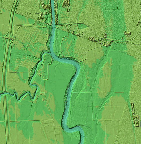
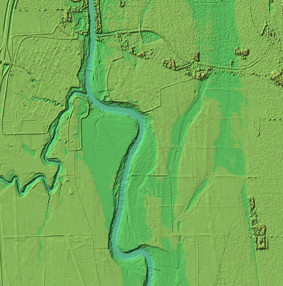
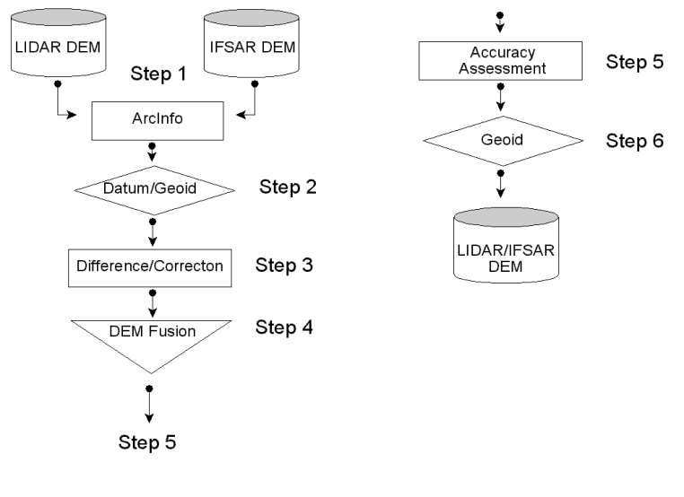