GPS, GIS, CADD integration for real property inventory and site modeling
Steve Morgan, Dan Jave, Luke Slings
Abstract: The Iowa Army National Guard is implementing an enterprise approach to capture, manage, and disseminate standardized, spatially accurate real property inventory and site modeling information. The core data is collected and processed utilizing Leica Survey-grade GPS, ArcInfo 8.1, ArcView 8.1, ArcIMS 3.1, and AutoCAD Land Development Desktop. The core data is incrementally updated as changes occur. The data layers are provided in Spatial Data Standard (SDSFIE) format with relational database connectivity. The final product is available to facility designers and managers, master planners, real property managers, training operations personnel, and environmental specialists for assessment and analysis purposes.
The Iowa Army National Guard is implementing an enterprise approach to capture, manage, and disseminate standardized, spatially accurate real property inventory and site modeling information. The core data is collected and processed utilizing Leica Survey-grade GPS, ArcINFO 8.1, ArcView 8.1, ArcIMS 3.1, and AutoCAD Land Development Desktop. The core data is incrementally updated as changes occur. The data layers are provided in Spatial Data Standard (SDSFIE) format with relational database connectivity. Spatial Data Standards for Facilities Infrastructure and Environment (SDSFIE) (formerly Tri-Service Spatial Data Standards) is a relational database structure developed by the CAD/GIS Technology Center. The final product is available to facility designers and managers, master planners, real property managers, training operations personnel, and environmental specialists for assessment and analysis purposes.
The enterprise approach is designed to reduce the volume of data entry by sharing core data to applications throughout the organization. The enterprise approach has several different components that are difficult to develop and become an effort to implement within themselves. The Iowa Army National Guard has begun implementing the system within the Construction and Facilities Management Office (CFMO). The architecture of the enterprise system relies on four basic elements including: Geographic Information System (GIS), Global Positioning System (GPS), Computer Integrated Facilities Management (CIFM), and Computer Aided Drafting (CAD). A typical architecture of the enterprise approach is illustrated in figure 1 (Figure 1 is a modified graphic from Booze Allen).
This paper will concentrate on the GIS and GPS portions of the enterprise approach. The Construction and Facilities Management Office is continuing to develop site plan models of all installations in a Geographic Information System (GIS). These facilities are located in over 50 different sites in the state, complicating data management. The Construction and Facilities Management Office also continues to develop highly accurate building models in CAD that reflect the current state of construction (See figure 2). These facility models are multi-use documents. They are used as "seed files" in production drawings and projects. Utilizing seed files reduces the level of effort required to develop new projects because the core layers are provided. When accessed by the GIS application, the file can be used to display data from the CIFM graphically. The CAD project drawings indicate changes that need to be incorporated into the model.
The GIS Site plan features are located using sub-centimeter grade GPS survey equipment and stored in Esri GIS format. The site plans are available to the GIS section for site development or environmental planning and to the Design Branch for production use in construction design, projects and construction documents.
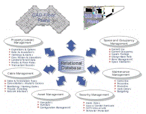
Figure 1. Enterprise Approach
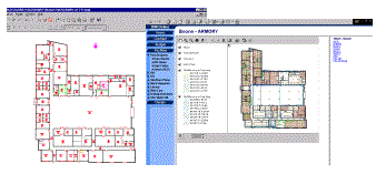
Figure 2. AutoCAD Building Models
These site plan models are intended for multiple uses. In addition to production CAD, Site Development Planning, and GIS projects, they are made available to other Iowa National Guard Directorates through an Internet Map Server (IMS) located on the CFMO Intranet web site. Most GIS attribute data is collected in the National CAD/GIS Center’s Spatial Data Standard.
The SDSFIE provides a structure for the creation of data layers with informative and appropriate attributes. Therefore the SDSFIE will be used as a data dictionary template for GPS data collection. This allows a smooth transition to an SDSFIE-compliant relational database structure in the future.
The Global Positioning System (GPS) consists of three major segments: space, control and user. The space segment consists of 24 operational satellites. The control segment consists of five Monitor Stations, three Ground Antennas, and a Master Control Station (MCS). The user segment consists of antennas and receiver-processors that provide positioning, velocity, and precise timing to the user. Of the three, we only deal with the user segment. Our goal was to combine the statewide readiness center sites, training sites, and cantonment site into a single theme.
The previously mentioned sites vary by location and intended use. There are 54 IARNG readiness centers across the state of Iowa. Readiness center sites typically include armories, storage buildings, maintenance buildings, and other assets. The readiness center sites serve as a place of work for several full-time guardsmen. The also serve as readiness center for specific IARNG units and detachments. The cantonment and training area sites refer to the Camp Dodge Iowa Army National Guard Military Reservation located in Johnston, Iowa. The Camp Dodge Military Reservation serves as the central training area for the State of Iowa. Camp Dodge is split into two separate areas geographically based on the intended use of the site. The training area is primarily agricultural fields with an existing gravel road network. The cantonment area is currently developed and primarily consists of the command, administrative, operations, and maintenance elements of the Iowa Army National Guard.
We chose to use differential GPS with a sub-centimeter Lieca survey GPS. The package selected includes both a base receiver and a roaming receiver. Using a combination of the two receivers allows for very accurate placement of a local benchmark derived from the state’s High Accuracy Reference Network (HARN). In future visits the benchmark is used as the location for the base.
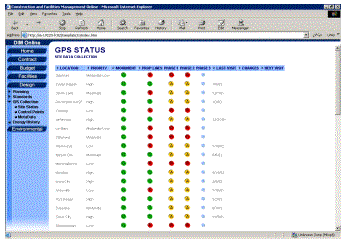
Figure 3. GPS Status-Site Data Collection
To achieve the highest level of accuracy and versatility from our data, GPS survey work for each installation is tied into Iowa’s High Accuracy Reference Network (HARN). Due to the distances between National Guard installations and suitable reference points, it is necessary to utilize the static survey capability of the Leica system to install a permanent control point on each installation. These control points also save time in the long run by eliminating the need for subsequent GPS survey crews to set up equipment off-site and broadcast differential corrections from long distances. The control point coordinates, location and recovery information, and processing parameters are compiled on the CFMO web page as hyper-linked text files. The control point installation status is also included on the GPS status-Site Data Collection web page (See Figure 3).
Once a control point has been established and the horizontal and vertical coordinates of that point are known, data collection can begin. By utilizing the real-time rover capability of the Leica system, points and nodes with accuracy better than five centimeters can be collected instantaneously. This accuracy is achieved through a differential correction broadcast from a unit located on the installation at the previously installed control point. The GIS data collection application in the Leica GPS system provides the ability to gather point, line and polygon information in the field. Feature attributes for population in the field are limited to those that are easily known or observable.
To ensure that the data used in projects is the most recent available, data follows an established path from initial capture to final output. GPS data is gathered and stored on PCMICA cards in the field equipment. These cards can be removed from the GPS receivers to allow raw GPS data to be imported to a PC. Leica SKIPro is used for processing static survey data as well as other point data. For points, lines and polygons gathered in real-time for site plans, Leica GISDataPro is used. With each import into the statewide model or independent project, new data from a card is automatically merged to existing data in the statewide installation site plan model. Also, by default the merged data is written into an Esri shape file format. ArcView 8.1 is the primary software used to modify the GPS collected data. There are strict parameters that are followed each time the GPS collected data is modified. The revised data is saved back to the statewide installation site plan model in shape file format and to personal geodatabase format. Both formats are available for use with ArcView, ArcIMS (through web Browser) and AutoCAD (through LDDT’s import shape file command). The personal geodatabase format is maintained to facilitate smooth transition to a relational database or spatial database engine (ArcSDE 8). The personal geodatabase is also used for area, perimeter, and distance analysis, which is automatically appended to the spatial data and editable in ArcView 8.1 or ArcINFO 8. The GIS information is updated by performing subsequent GPS data collection visits.
Site plan data is imported into CAD applications through AutoCAD Land Development Desktop’s shape file import command. Consistent with office CAD standards, this data is imported in the UTM Zone 15N, NAD 83 coordinate system. However, the LDDT project is assigned the UTM Zone 15N, NAD 83 US Foot coordinate system to convert the units from meters to feet and properly display the data due to the rotation of the NAD 83 projection using the dvvpoint command. The dvvpoint command refers to the ability to choose from two different viewing options including user coordinate system (UCS) orientation view and projected view. Future implementation of a relational database will allow CAD applications to access data directly through ArcSDE and CAD Integrator, without the import shape file command.
The integration of the GIS and CAD data is dependent upon the project that is being developed. The integration of this data is represented in figure 4. The union of CAD and GIS is demonstrated in CAD projects that incorporate a site plan managed in GIS or a GIS project displaying CAD objects. Each application has proprietary file formats but has the ability to import or read the other’s format through extensions. For example Esri’s ArcView can display AutoCAD files with the CAD extension. Likewise, AutoCAD can display Esri shape files with the AutoDesk Map add on.
The center or the union of CAD, GIS and Data is exemplified by a GIS project that displays a CAD floor plan and ties current data (like a room finish schedule) from a database to each room. The nature of the information connected to the rooms is only limited by imagination. Room finish, asbestos sample results and open work orders are types of information that can be queried using ArcView 8 or ArcIMS.
In this example, the Data ring contains the Facility Center database. In reality, any tabular data source is within this ring. The Real Property data set contains both floor plan and site plan data. The floor plan data is maintained through the CAD Integrator, while the site plan data is maintained manually through the GIS.
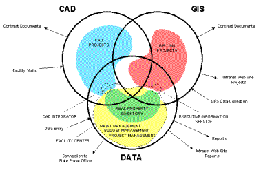
Figure 4. GIS, GPS, CAD Integration Model
The majority of GIS projects are within the GIS-only area of the GIS ring. The next largest volume of projects involves GIS with connections to various data sources. The inputs and outputs are not all inclusive; they are just to demonstrate the movement of information. GIS information is output through contract documents and Internet Map Server projects. The GIS-related projects that are developed using ArcView IMS or ArcIMS are automatically updated each time the relational geodatabase or TSSDS folders are re-populated (See Figure 5). Our office policy due to recent events is to make site and floor plans available only to known users, so it is specifically available to our Intranet.
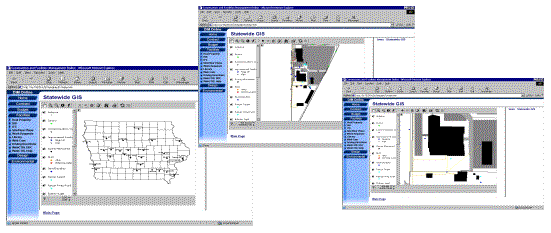
Figure 5. .ARCIMS Statewide Site Installation models
The utilization of an enterprise system to disseminate, manage, and capture real property and site model information can be very complex. The advantages of utilizing such a system, however, outweigh the complications. The implementation of this approach has enabled the Iowa Army National Guard to realize many of these advantages and will continue to do so as it progresses.