ª Instituto de Investigación de Recursos Biológicos Alexander von
Humboldt
Calle 37#8-40 Mezzanine, Bogotá
Colombia (South America)
b Departamento de Economia
Facultad de Ciencias Económicas y Administrativas
Pontificia Universidad Javeriana
Calle 40 N 6-23,
Bogotá
Colombia (South America)
* Corresponding author
The design and implementation of a biodiversity indicator system to follow up policies in the Colombian Amazonia was undertaken. We conducted a temporal and spatial analysis of biotic and abiotic data using remote sensing and geographical information systems. We tested the system in two moments of time (1980s and 2000) in five pilot areas of approximately 500,000 ha each. Both ecological and socio-economic indicators were calculated for local conditions and summarised in a simple way: the state, pressures and changes in biodiversity in the Amazon. On the one hand, we used a landscape ecology approach to calculate indicators of vegetation cover and forest fragmentation in terms of landscape metrics such as number of patches, mean patch size, mean shape index or mean nearest neighbour distance. On the other hand, we used indicators of human influence such as demographic pressure, quality of life and economic activities indicators. We analysed the changes in forest cover in terms of human pressure using these indicators. Results show that there has been a major forest loss and deterioration in the Amazonian areas nearer to the Colombian Andes in terms of natural ecosystem cover and fragmentation in the last 15 years. These changes coincide with areas where the population pressure and land use changes have been and are high.
Colombia is one of the most diverse regions for flora and fauna in the world and has been identified as a mega diverse country. The loss of biodiversity and landscape transformation is occurring at such a rate that today entire ecosystem types are under threat of disappearance. Humans have influenced the landscape and land cover throughout the entire country.
Because the loss of biodiversity and the alteration of ecological processes are difficult to measure directly, the implementation of landscape ecology and conservation biology concepts coupled with remote sensing and geographic information systems tools, offer a great potential to monitor and analyse landscape parameters that can be used as an approach in the evaluation of the state of conservation of a region. To determine landscape pattern state and tendencies makes possible to predict the ability of an ecosystem to maintain ecological processes and it becomes an analysis scale to be considered in the political decision making for the management of the natural resources (O’Neill et al, 1997; Dinerstein et al, 1995).
Additionally, and to analyse the state of biodiversity in a region is necessary to develop measures able to not only quantify landscape patterns but also to express relevant manifestations of the biodiversity in a moment in time of the pressures exerted on the biodiversity by the human activity and of the advance of the institutional actions oriented to change the state of the biodiversity and the pressures on it (Rudas et al, 2002). The role and importance of new technologies such as remote sensing and geographic information systems in assimilating, collating, and disseminating biodiversity data is widely acknowledged (Soulé & Kohm 1989; Lubchenco et al. 1991; Stoms & Estes 1993). These technologies are a research tool for the investigation of biological diversity and can make data readily available for scientists and decision makers to execute their biodiversity planning and lead to better conservation and management strategies.
Most studies on ecosystem cover and fragmentation are centred in the quantification of those changes (Vogelmann, 1994; Ranta et al, 1998; Steininger et al, 2001a, 2001b) and in the effects that these can have on the ecological processes from a local to a global level (Klein, 1989; Carvalho & Vasconcelos, 1999; Gascon et al, 1999; Davis & Margules, 1998; Laurance et al, 2000 Laurance et al, 1998; Nepstad et al, 1999).Some of these studies formulate in their conclusions hypothesis on the possible causes of the observed patterns, but few studies quantify these possible causes simultaneously to the changes in the state of the biodiversity of a region. In the Brazilian Amazonia exist some studies with an approach very similar to the goals in this study modelling the social and demographic determinants of the Amazonian deforestation (Wood & Skole, 1998).
Analysis involving both biotic and anthropogenic data are critical for understanding the consequences of human activities that alter our natural environment. Humboldt Institute has developed an indicator system to follow up policies regarding Biodiversity in Colombia. To develop this indicator system, we used remote sensing, GIS, and emerging technologies in the tropics to make a first attempt towards monitoring and analysing the state of natural ecosystems in the Amazonia, an approach that has not been undertaken previously in this part of the country. The model adopted is the state-pressure-response framework and the first pilot project took place in the Colombian Amazonian.
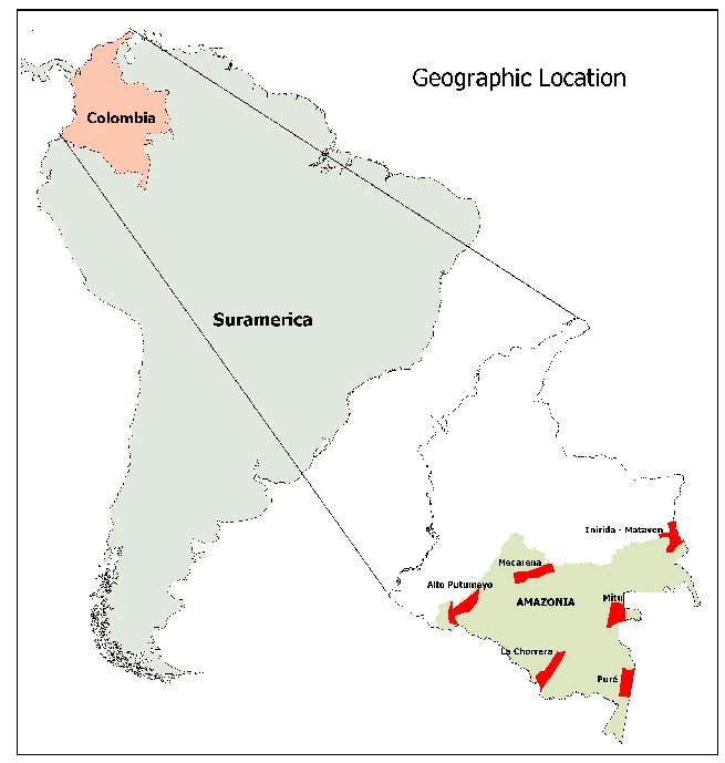
Colombia stretches through the north-western end of South America between 12º26’46 N, 4º13’30 S, 66º50’54 E and 79º02’33 W. It is the fourth largest country in South America, after Brazil, Argentina and Peru, and covers an area of approximately 1.142.000 km2. Colombia is a geographically variable country. The western part is mostly mountainous but major parts of the country are plains located below 500 m. One of Colombia natural regions embraces the Amazonian forest. The Amazonian region covers 7.1% of the whole Amazonian Basin. It is a highly diverse region, where climate, soils and topography determine the habitat and landscape complexity of the area. Tropical lowland rainforest, Tropical ombrophilous alluvial forest, Tropical ombrophilous submontane forest and rocky vegetation are the most important ecosystems. Ten protected areas represent 65.6% of all current protected areas in Colombia. Six pilot areas (11151.jpg) of approximately 500,000 ha were analysed using 1985 and 2001 Landsat Images.
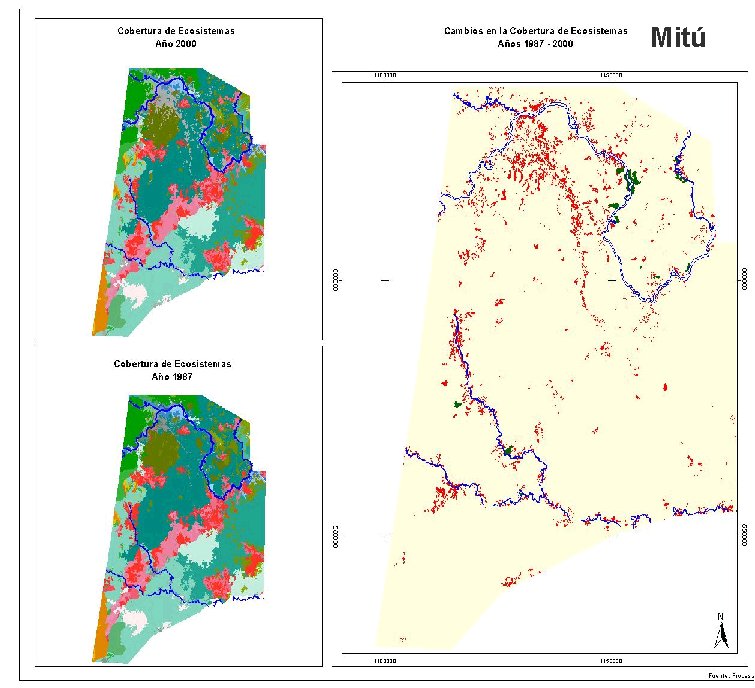
Ecosystem data was derived from remote environmental mapping. Major ecosystem types were determined by a combination of manual and automated interpretation of satellite images supplemented with secondary information and ground-truthing.We used both ERDAS Imagine (ERDAS Inc. 1999) remote sensing processing software and the GIS software Arcview(Esri 1998) to integrate all the data. Because of this interpretation, we obtained a map of ecosystems for two different moments in time of five of the six pilot areas at a scale of 1:250.000 and looked at changes in natural cover (11152.jpg).
Indicators are quantitative measures or expressions designed to provide clear information about something of interest in a simple and communicative way. During this research, we devoted our efforts to the development of a reliable and simple indicator system that could be able to inform quickly and easily about the state, pressures and responses that affect the status of biodiversity in the Amazonia.
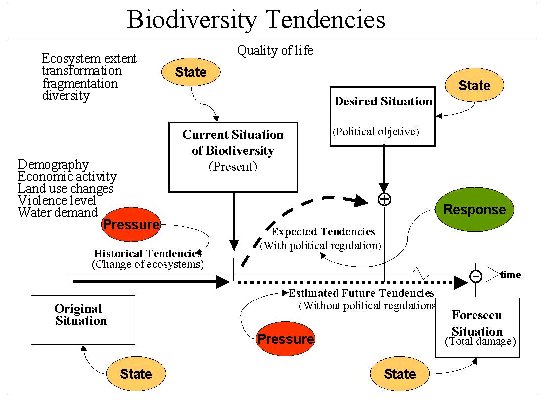
We compared status and trends of the indicators against a reference state used as baseline following the conceptual scheme summarised in 11153.jpg. We used a landscape level approach as “surrogate” for species and communities diversity indicators and developed indicators for monitoring over time to show conditions and trends assuming that the largest biodiversity changes caused by humans result from land use changes. The following Table (Table 1) summarises the indicators developed and measured in the six pilot areas of the Amazonia:
Table 1.
|
Category |
Type |
Source of information* |
|
|
State |
Ecosystems biological State Indicators |
Ecosystem Extent (80’s - 2001) |
Satellite images, secondary information, field work. |
|
Population quality of life State Indicators |
Quality of life of the population (ICV) |
Index developed from data on education, family size, household building quality material, water availability, garbage collection, household density, etc (DNP) |
|
|
Hydrological offer State Indicators |
Hydrological offer |
Hydrological information from IDEAM |
|
|
Pressure |
Demographic Pressure indicators |
Number of inhabitants (urban/rural) |
Census information 1951-1964-1973-1985-1993 (DANE) |
|
Pressure indicators due to farming |
Percentage of soil in farming |
Agriculture and Rural Development Ministry |
|
|
Economic intensity pressure indicators |
Economic activity (bank deposits per cápita) |
Fundación Social |
|
|
Pressure over hydrologic |
Water offer/demand |
IDEAM |
|
|
Pressure due to armed conflicts |
Levels of violence (percentage of deaths due to violence) |
Information SISD-DNP |
|
|
Response |
Protected Areas response indicators |
Areas declared of special management (AME)
|
UAESPNN |
* DNP, Departamento Nacional de Planeación; IDEAM, Instituto de Hidrologia, Meteorologia y Estudios Ambientales; DANE, Departamento Administrativo Nacional de Estadística; UAESPNN, Unidad Administrativa Especial del Sistema de Parques Naturales Nacionales
Indicators of demographic and economic structure were derived from a population and agricultural census. The quality of life information was obtained directly from the Departamento Nacional de Planeación and it is a synthetic index that includes information on education, family size, household building quality material, water availability, garbage collection, household density and income. We also used data such as the land area devoted to ranching and farming. Our goal was to offer information within the region relatively cheaply and rapidly and present it in an easily interpretable way in order to support decision-making in the Colombian Amazon. All these indicators were either measured or analysed using GIS and many of the state indicators were based on the ecosystem mapped. Fragmentation indicators were calculated using the software Fragstats (McGarigal and Marks 1995), most of the others were calculated using normal GIS and statistical analytical tools.
Although we have not completed the process of analysing all our findings, it is possible to present preliminary but very important results. In the six pilot areas, whose total extension is of 4,140,000 ha (9,39% of the Colombian Amazonia), the biomes more representative are tropical humid forests (61.81%) and helobiomes of the Amazonia (11.57%). Over the 15-year period of analysis (1985-2000) the pilot area with a higher percentage of natural ecosystems are Puré (99.23%), Inírida-Matavén (94,37 %) and Mitú (91.23%). The area with greater degree of transformation is the zone of Alto-Putumayo near the Andes, with only a 28% of natural ecosystems left in 2001, followed by Macarena with 68.57% (Figure 1). These agree with the results obtained on the annual rate of natural ecosystem loss for the same areas.The highest rate corresponds to the Putumayo(3,73%), followed by Macarena (0.86%) and further away Mitú (0.34%), Inírida-Matavén (0.23%) and finally Puré with 0,1% annual loss rate (Figure 2).
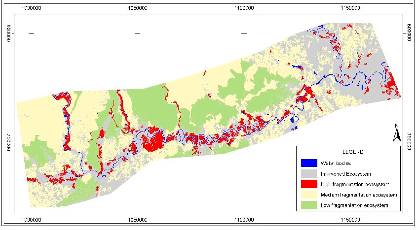
In general, the degree of fragmentation of each site follows the same order with highly fragmented natural ecosystems in Putumayo and Macarena pilot areas and less fragmentation in the other three. For each of the sites, a map of degree of fragmentation was made (1154.jpg), in which it can be clearly observed how the pattern coincides with the colonisation frontier through the only transportation network in the Amazonia: rivers. This pattern of fragmentation and deforestation is clearly very different to those of the Brazilian Amazonia where the construction of roads is one of the drivers of their particular pattern (e.g. Rhondonia).
Clearly, the Macarena and Alto-Putumayo are the two areas that have been more dramatically changed since the mid 1980’s mainly due to forest extraction, cattle farming and illegal cropping. Both of them are located near the Andes where more than half of the population live.
In the Putumayo region, in an area of around 500,000 ha studied there has been a major decrease in the percentage of natural ecosystems (from 42% to 28%), with the previously mentioned annual change rate of 3.73%. Fragmentation of natural forest has increased dramatically. Current rural population density is 9.98 habitants/sqkm but has increase from 1.98 (1951), 2.97 (1964), 4.63 (1973), 7.24 (1985). In the 1950’s oil extraction produced an immigration of population to this area. However since the 1970s and partly due to a lack of government policies, illegal activities outbreak (e.g.. coca growing and the presence of violent paramilitary and guerrilla groups). The patterns on the landscape are the result of forest extraction, followed by cattle farming combined with illegal cropping. In a similar way and despite of being slower in the Macarena region there has also been a substantial decrease in the percentage of natural ecosystems (from 79% to 68%) with an annual change rate of 0.86%. Natural ecosystems are becoming increasingly fragmented. Rural population density is lower than in the Putumayo pilot area: 2.45 habitants/sqkm increasing from 0.56 in 1973 and 1.51 in 1985. In the 1970´s and 1980´s began an unsuccessful slash and burnt attempt for establishing agriculture economies, which slowly led to a transformation into grazing areas partly encouraged by a land reform. Recently these areas have been transformed also into illegal cropping, partly due to the establishment for a few years of a peace talk territory without government presence.
The results also show how the areas that are more degraded coincide with areas of high population density pressure (Figure 3, Figure 4), low quality of life and high levels of violence allowing us to establish a clear relationships such as the one between population density and percentage of natural ecosystem cover in the different sites (Figure 5).
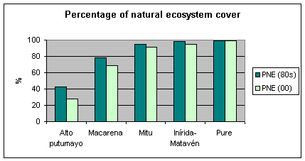
Figure 1. Percentage of natural ecosystems in the pilot areas (80´s and 00’s)
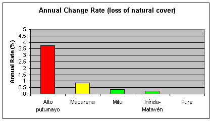
Figure 2. Annual natural ecosystem loss rate in the pilot areas for a 15-year period
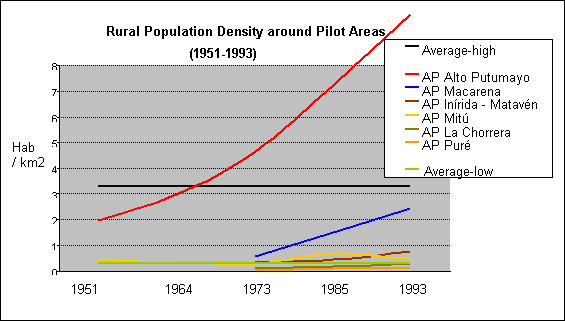
Figure 3. Rural population density around Pilot areas
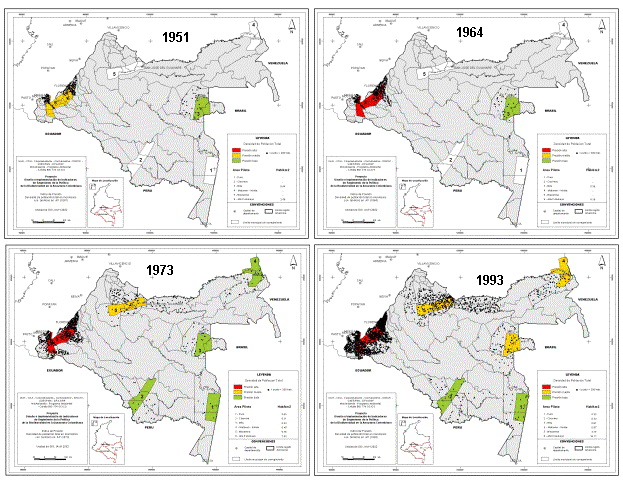
Figure 4. Population evolution around pilot areas from year 1951 to 1993. Colours indicate level of pressure (white, no info available; green, low; yellow, medium and red, high)
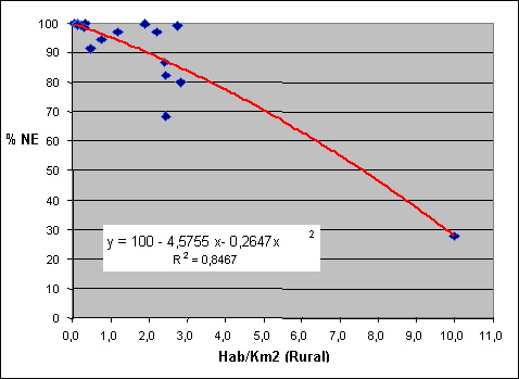
Figure 5. Relationship between rural population density and percentage of natural ecosystems left.
Analysts have applied different approaches to study changes and their causes in natural ecosystems. Over a 15-year period covered by the study, there has been an increase in the magnitude of natural ecosystem loss. This loss is a function of the level of pressures on the natural capital in the region. The indicator system proved to be valid to follow up the effects of socio-economic, political and productive pressures upon biodiversity at the landscape level (e.g. surface, diversity and ecosystem fragmentation). The GIS methods developed during this project will be a very valuable tool for policy and decision makers in the Amazonian, however it remains to be seen how successful this approach may really be. We expect that its use will focus on identifying further data and interpretation problems, and on developing further some of the indicators. We have only covered less than 10% of the Amazonia and clearly many important sites could be studied further. The biggest challenges are time and cost for some field sampling that need to be done to ground-truth the ecosystem mapping. Furthermore, we want to develop an indicator at species level that could eventually be added to the system. Nevertheless, taking a retrospective look to describe the state of an ecosystem proof to be useful to assess the need or effectiveness of biodiversity policy actions and remote sensing offers rapidly and accurate sampling and perhaps the only affordable means of looking at processes over large spatial areas. Obviously future spatial models using GIS can be used to make a variety of predictions about changes in this region and to indicate how these changes will affect biodiversity and that is where we are heading. However, there is no doubt that GIS analysis and outcome maps are a good way of communicating information and warning managers, keeping in mind that those indicators have to be quantitative so that the results can be compared over time and space in order to be useful, and that the future is in further interpreting, modelling and predicting the dynamics of our natural capital through analysis involving both remotely sensed and social data.
Further information on this project can be found in Spanish at http://www.humboldt.org.co
We want to thank Juan Carlos Betancourth, Pedro Botero, Carol Franco, Milton Romero, Jaime Forero for their work in this project. We also want to thank the participant institutions such as CDA, Corpoamazonia, Cormacarena, Instituto Sinchi, Unidad de Parques and the Ministerio del Medio Ambiente. Finally, we want to thank Ricardo Gonzalez for his contribution on the preparation of this document.
Carvalho, K. S. and H. L. Vasconcelos (1999) ‘Forest fragmentation in central Amazonia and its effects on litter-dwelling ants - analysis by ant communities’, Biological Conservation 91 (2): 151-157
Chaves, M.E. and N. Arango. Editors. 1998. Informe nacional sobre el estado de la biodiversidad 1997. Instituto de Investigación de Recursos Biológicos Alexander von Humboldt, PNUMA and Ministerio de Medio Ambiente. 3 vol. Bogotá, Colombia.
Davies, K. F. and C. Margules (1998) ‘Effect of habitat fragmentation on carabid beetles: experimental evidence’, Journal of Animal Ecology 67: 460-471
Dinerstein, E., D. Olson, D. Graham, A. Webster, S. Primm, M. Bookbinder y G. Ledec (1995). Una evaluación del estado de conservación de las ecorregiones terrestres de América Latina y el Caribe. Banco Mundial y Fondo Mundial para la Naturaleza. Washington, D.C.
Gascon, C., T. E. Lovejoy, R.O Bierregaard (Jr.), J.R. Malcolm, P. C., Stouffer, H. L. Vasconcelos, W. F. Laurance, B. Zimmerman, M. Tocher and Borges S. ‘Matrix habitat and species richness in tropical forest remnants’, Biological Conservation 91(2): 223-229
Klein, B. C. (1989) ‘Effect of forest fragmentation on dung and carrion beetle communities in central Amazonia’, Ecology 70(6): 1715-1725
Laurance W.F., P. Delamonica, S. G. Laurance, H.L. Vasconcelos and T. E. Lovejoy (2000) ‘Conservation: Rainforest fragmentation kills big trees’, Nature 404: 836
Laurance W.F., S. G. Laurance and P. Delamonica (1998) ‘Tropical forest fragmentation and greenhouse gas emissions’, Forest Ecology and Management 110(1): 173-180
Lubchenco, J., Olson, A.M., Brubaker, L.B., Carpenter, S.R., Holland, M.M, Hubbell, S.P., Levin, S.A., MacMahon, J.A., Matson, P.A., Melillo, J.M., Mooney, H.A., Peterson, C.H., Pulliam, H.R., Real, L.A., Regal, P.J. and P.G. Risser. 1991. The sustainable biosphere initiative: an ecological research agenda: a report from the Ecological Society of America. Ecology, 72: 371-412
Mcgarigal, K. and B.J. Marks. 1995. Fragstats: spatial pattern analysis program for quantifying landscape structure. Gen. Tech. Rep. PNW-GTR-351. Portland, OR: U.S. Departament of Agriculture, Forest Service, Pacific Northwest Research Station, USA.
Nepstad, D.C., V. Veroassimo, A. Alencar, C. Nobre, E. Lima, P. Lefebvre, P. Schlesinger, C. Potterk, P. Moutinho, E. Mendoza, M. Cochrane and V. Brooks (1999) ‘Large-scale impoverishment of Amazonian forests by logging and fire’, Nature 398: 505-508
O´Neill, R.V., C.T. Hunsaker, K.B.Jones, K.H. Riitters, J.D. Wickam, P.M. Schwartz, I.A. Goodman, B.L. Jackson and W. S. Baillargeon (1997) ‘Monitoring environmental quality at the landscape scale: Using landscape indicators to assess stability’, BioScience 47(8): 513-519.
Ranta, P., T. Blom, J. Niemela, E. Joensuu and M. Siitonen (1998) ‘The fragmented Atlantic rain forest of Brazil: size, shape and distribution of forest fragments’, Biodiversity and Conservation 7: 385-403
Rudas G., D. Armenteras, S.M. Sua and N. Rodríguez (2002). “Indicadores de Seguimiento de la Política de Biodiversidad en la Amazonia Colombiana –2001”. Informe Final de Resultados. Proyecto Diseño e Implementación del Sistema de Indicadores de Seguimiento de la Política de Biodiversidad en la Amazonia Colombiana. Instituto Humboldt, CDA, Corpoamazonia, Cormacarena, Instituto Sinchi, Unidad de Parques, Ministerio del Medio Ambiente (Crédito BID 774 OC/CO), Bogotá, Colombia.
Soule, M.E., and K.A. Kohm. (editors) 1989. Research Priorities for Conservation Biology. Washington D.C., Island Press, USA.
Steininger, M.K, C. J. Tucker, J. R. G. Townshend, T. J. Killeen, A. Desch, V. Bell and P. Ersts (2001b) ‘Tropical deforestation in the Bolivian Amazon’, Environmental Conservation 28 (2): 127-134
Steininger, M.K, C. J. Tucker, P. Ersts, T. J. Killeen, Z. Villegas and S. B. Hecht (2001a) ‘Clearance and fragmentation of tropical deciduous forest in the Tierras Bajas, Santa Cruz, Bolivia’, Conservation Biology 15(4): 856-866
Stoms, D.M. and J.E. Estes. 1993. A remote sensing agenda for mapping and monitoring biodiversity. Int. J. Remote Sensing, 14: 1839-1860.
Vogelmann, J. E. (1995)‘Assessment of forest fragmentation in Southern New England using remote sensing and geographic information systems technology’, Conservation Biology 9(2): 439-449
Wood, C. H. and D. Skole (1998) ‘Linking satellite, census and survey data to study deforestation in the brazilian amazon’. In: Liverman, D. (ed) People and Pixels: linking remotes sensing and social sciences. National Research Council, USA, 70-93.