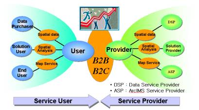
[Figure-1] Conceptual diagram of business model
Jay-joon Yoon, Chea-seung Kim, Ik-hoi Kim
Introduction to GeoNetKorea
GeoNetKorea is the
stage where GIS information is commonly used through the
modification of Geography Network of Esri whose purpose or
intention is to be suitable for Korean environment.
Spatial data and map service shall be provided by utilizing
the merit of ArcIMS and using the internet
network.
Its major services are Framework DB, DSP(Data Service
Provider), ASP(ArcIMS Service Provider), and Solution and so
on. Framework DB, which is the basic spatial data covering
over all the South Korea presents the strategy of building the
layer and it’s utilizing plans. DSP is for the
introduction on collection of members and metadata, and ASP
presents the collection of members and their activities.
Solution, a kind of map service, provides the services such as
guiding the demanded location, location of TOTO shops,
location of Homestaykorea’s host. We hereby introduce
our future plans to do with telling the difference from
Geography Network.
· Background and goal
CADLAND, the best
GIS Solution provider in Korea, has 2,077 clients in the
variety of fields such as government agencies, companies and
institutes. Currently, our clients utilize GIS
application systems in the variety of fields, and the spatial
data, the base to the system, is based on the layers of
variety of map scales.
Importance of spatial data is increased with the extensive
development of GIS application system, but overlapping
investments have been made, as the information on building
status of each spatial data is not shared. In addition
to it, numbers of application fields of GIS are not shared in
terms of
technology.
As previously stated, GeoNetKorea was planned for the common
use of spatial data and GIS technology. As described on the
following [figure-1], it is planned and designed to share the
GIS information to users and providers.
[Figure-1] Conceptual diagram of business model
Service User shall be the regular member using the simple map service or the one who is interested in GIS. The regular member may use the variety of services such as information on the spatial data, map service and internet GIS Solution and so on. The provider is the membership organization or a person that provides the user with internet GIS Service in the forms of B2B or B2C after enrollment as member of GeoNetKorea.
· Strategies and target business
For providing the stage of common use of GIS information, GeoNetKorea focuses on using numbers of extension layers based on Framework DB, and all the spatial data shall be applied to map service based on the locations information after preprocessing.
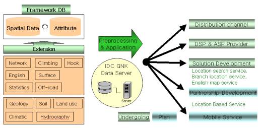
[Figure-2] Building strategies of framework DB and
applications
The major undergoing tasks are the production and distribution of Framework DB, acquisition of extension layers that are developed in company or through outsourcing by the membership of DSP, map service by ASP membership, and development of internet GIS Solution that are combined by DSP and ASP. Process of all the businesses or projects are made based on the following GeoNetkorea homepage. In the future, this site shall be improved as the one providing the common use of information on GIS with connecting spatial data provider and purchaser, developer of map service and common netizens in domestic or foreign countries.
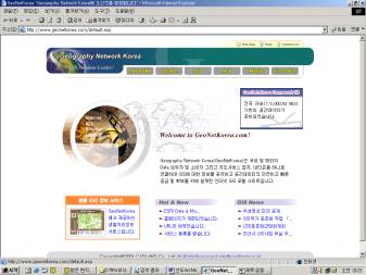
[Figure-3]
GeoNetkorea((http://www.GeoNetKorea.com)
Homepage
· History and implementation
•
History
- 2000. 8 : Submit
a paper for Business
Model
Patent
-
2000. 10 :
Homepage of GeoNetKorea was initially
developed
- 2001.
7 : Extension DB acquisition strategy based on Framework DB
was
established
- 2001. 10 :
Homepage of GeoNetKorea are upgraded
•
Implementation
- 2001. 5
: Map service for locating the place was
developed
- 2001.
7 : Framework DB for transportation and logistics are
accomplished
- 2001.
9 : GeoDataKorea framework DB is
building
- 2001. 12 :
Map service for locating TOTO shops was
developed
- 2002.
4 : Demographic and spatial data in English extension was
established
- 2002. 4 :
Locating map service for Homestaykorea Host in English was
initially provided
· Building strategies
Framework DB is the spatial data that is basic to all the GIS Application solutions and intended for covering all over the South Korea. Projection origin was adjusted to allow all the places in South Korea to be a positive and continuous spatial data. Overlapping the boarder lines of the roads and streets as the basic unit for revising all the layers maximizes the effectiveness in using and maintenance of all spatial data.
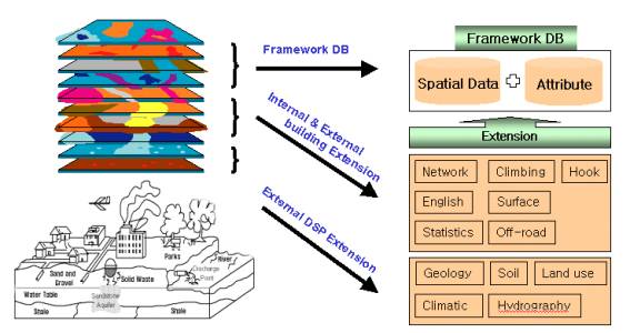
[Figure-4] Building strategies of Framework DB and Extension
DB
The GeoDataKorea
Framework DB is the spatial data whose scale is 1:5,000 based
on national GIS (NGIS) basic data. Long-term big
investment is required for building this spatial data, so we
proceed with this project with our business
partner.
Extension DB is the layers with scaleable and projective that
are available to be overlapped with the ones for Framework DB.
Commercial layers which are produced by GeoNetKroea or
external DSP members and variety of layers provided by DSP
Members are available to use, and if variety of Extension DB
and Framework DB are overlapped, their effectiveness shall be
maximized.
· Database contents
For the details of
layers for GeoDataKorea, refer to the following [Table-1], and
it consists of 11 layers and about 50 themes. ED field
is available for all the themes, and building method and
history are managed by the code. For example, for the
purpose of national security some area not took the aerial
photograph. In this case, paper map is used and management of
history is needed for this
area.
CNS(Car Navigation System) retains Framework DB providing the
logical transportation information with the structure of
link-node as the DSP member.
[Table-1] GeoDataKorea Framework DB
| Layers | Themes |
| Index | 1:5,000 / 1:10,000 / 1:25,000 / 1:50,000 |
| Rail | network of railway, railway station, station name of railway, railway bridge, network of subway, subway station, station name of subway, outlet numbers of subway station |
| Hydrography |
water system, reservoir, reservoir name, river, river name |
| Roads | express highways, tollgate, interchange, road width, inner part road of housing area, network of road, bridge, bridge name, tunnel, tunnel name, road name, over pass |
| Building | office building, government and public office building, apartment, tenement house |
| Tributary | Park, park name, open space, sports ground |
| Facilities | location of industrial park |
| Terrain | contour, height, under sea level |
| Boundary | province/city, city/county/district, dong |
| Annotation | descriptive text of POI(Point Of Interest) |
| Parcel |
the record of land registration |
Acquisition methods of Extension DB are Frame Data, Private Data and Public Data. Frame Data is the commercial layers that is closely related to Framework DB and is the Extension DB to be produced by us. Network, Statistics, and Annotation in English are available. Private Data is on the variety of themes such as mountain climbing, hook, surface and off-road those are handled by the company or agency specialized in producing the spatial data. The Public Data is the themes on geology, soil, land use, climatic, and hydrography, which are retained by the government agencies. For the details of extension DB, refer to the following [Table-2].
[Table-2] Extension DB
| Extension | Description | Acquisition type |
| Network | Link-node structure for transportation information | Frame |
| English | descriptive text information translated to English | Frame |
| Statistics | population and household statistics joined to Dong, city/county/district boundary |
Frame |
| Climbing | mountain climbing path, mountain peak, dangerous area, shelter | Private |
| Hook | fishing information of reservoir, dam, and seashore | Private |
| Surface | 3 dimension representation by TIN and lattice | Private |
| Off-road | mountain road, unpaved road | Private |
| Geology |
geology, earthquake, underground resources |
Public |
| Soil |
detailed soil map, cultivation suitability |
Public |
| Land use | land cover, land use properties | Public |
| Climatic | temperature, wind, wind velocity, humidity | Public |
| Hydrography | water system, drainage basin, reservoir description information |
Public |
All above spatial data and attribute data based on the location are the basic contents for the internet map service.
GIS related company, government agency, college institute or individual that is providing the GeoNetKorea with map service and spatial data shall become of Provider. Enrollment shall be processed through the internet and then Provider writing the subscription purpose and the ability of GIS developer. And also you may decide the field to act. The Provider may use or publicize the available spatial data and develop the map service with using the Framework DB. In addition to it, the Provider shall supply ArcIMS and Esri Software in the form of evaluation, which are required for building of internet map service and education and technical support as well.
· DSP(Data Service Provider)
Most of spatial data
represents physical shapes of surface. The intention or
purpose of DSP is to increase the effectiveness of all the
spatial data retained by group or agencies through the common
use. First, the various types of spatial data retained
by the enrolled members shall be publicized by the detailed
metadata. And also, it allows the user to verify the
contents of spatial data prior to using by sample data.
The following figure and diagram shows the process of looking
up the DSP spatial data. Everyone easily identify all of
spatial data based on metadata and verifying the sample data,
which is supplied by ArcIMS map service. When there is any
request from Provider, whole spatial data shall be available
to be serviced at the Provider’s server or GeoNetKroea server
using the ArcIMS.
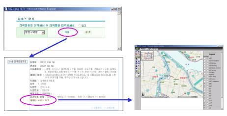
[Figure-5] Identify spatial data based on
metadata
Basically,
various themes to be supplied by DSP shall be overlapped and
used in the various ways on the Framework DB. In another
word, DSP enables to raise the value of it’s data based on
the location. For example, the provider
who provides the phone numbers enables to add the information
on the locations of the shops by address matching. In this
case, parcel theme need
necessary to
relate. This means that the locations of x and y shall be
added to the phone numbers so, the value of information shall
be raised.
There are various types of establishing the spatial data of
DSP such as Projection Data, Editing Data, Translation Data
and so on. Projection Data is the layer that is
available to be overlapped with Framework DB only by operating
in the projection method. Editing Data means the
production of layer through manipulation and revising works
for building the spatial data. Translation Data requires the
transformation work to be used at the Esri Software through
the modification of structure of spatial data and commonly
used the macro programs. At the DSP we may share the
information on AML and Avenue macro programs required for
building the spatial data, and supplying the evaluation
edition of Esri Software for Provider.
· ASP(ArcIMS Service Provider)
For ASP, group or
agency with products, client and technology in the field where
internet GIS application shall be applied shall be
involved. Development of software, hardware and spatial
data, and maintenance are required for developing the internet
GIS so, big investment is
needed.
Therefore, ASP members shall describe the reason for
enrollment of member and the required supports. And the
enrolled Provider shall have the lots of benefits needed for
developing the internet GIS. ArcIMS evaluation edition,
Framework DB by area/layer and educating opportunity on ArcIMS
shall be provided to the enrolled members. The completed
map service after development process shall be publicized
through the GeoNetKorea. We plan to draw
lots of interests and participation by holding the ArcIMS
developer competition at the CADLAND GIS Workshop for the year
of 2002.
[Figure-6] An example of ASP map service
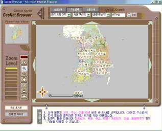
· Map service based on location
DSP and ASP are combined into the Internet GIS Solution. In another word, map service to be used for specific field was developed through the combination of Extension DB of DSP based on Framework DB for national wide map service.
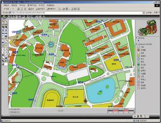
· Map service for locating the place
Map service for locating the place is the looking up service in national wise and shall be provided to internet user for nothing. Its’ major functions are looking up address, building and key word. If you want to look up the address, you may move to the place by entering the required parcel number after selecting the required province/city, city/county/district, dong in written order. When you want to look up the building, you may move to the place on the required building place by entering the name of building after selecting the province/city, city/county/district, dong in written order. For keyword looking up, enter the specific key word then you may move to the required place after searing for the annotation corresponding to the one of the required feature.
[Figure-7] Map service for locating the place
· Map service for Locating the shops
This is the map
service for the locations of Sports TOTO Shops. Its'
major functions are looking up the address, subway and key
word. Looking up the address is the service for looking
up the TOTO Shop, which is nearest to your address. (Select
the province/city, city/county/district,
dong).
Looking up the subway allows you to look up all the TOTO
shops within 300m from the selected subway station after
selecting the subway line number. Key word looking up
provides the user with the information on the selected shop
after searching for the name corresponding to the entered key
word with the names of
shops.
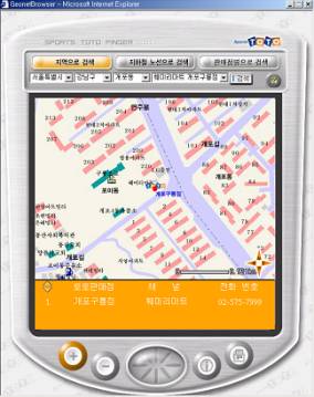
[Figure-8] Map service for locating TOTO shops
· Map service for Homestaykorea's host
We provide the map service for locating the Homestaykorea’s host in English. Its’ major functions are looking up the address, zip code and World Cup Stadium. You may look up the location of the available host by selecting the province/city, city/county/district, dong. Function of looking up the zip code allows you to look up the location of required host upon entering the zip code. The function of looking up the World Cup stadium provides the map service for 10 World Cup stadiums in Korea.
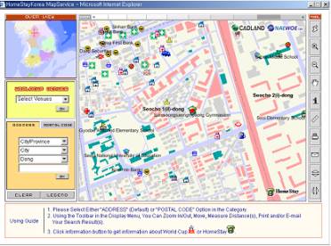
[Figure-9] Map service for Homestaykorea's hosts
Even if business model of Geography Network is used for GeoNetKorea, our GeoNetKorea is different from the Geography Network in terms of three points. First, we focus on the business to be used to the internet GIS application fields through the practical combination of various extension DB and framework DB, which is cover national wide. Second, spatial data becomes of the valuable data only when it is manipulated and revised. Third, data is not limited to the spatial data, various social and economical attribute information shall be included into it. In another word, more valuable spatial data may need additional information. There are phone numbers, statistic information, building information, apartment information and income information.
In the future, we, GeoNetKorea team, plan to proceed with the following fields.
• Map Contents
Service
- All the Extension spatial data
to be used with framework DB shall be
provided
- Numbers of spatial data and
metadata on the social and economical information shall be
provided
• Internet Map
Solution
- Differentiation from our
competing companies by developing geoprocessing map service
with using the function of ArcMapServer
• Mobile
Service
- Shall provide the cellular
phone and PDA with map service
• Link to the Geography
Network
- Is in cooperation with
Geography Network in spatial data and map service in
English
Hee-beom Lee, CADLAND, Inc., Executive director of special interest department
Alex Lee, CADLAND, Inc., Senior manager of internet GIS team
Seok-il Yoon, CADLAND, Inc., Manager of DSP and ASP
Cheol-seung Han, CADLAND, Inc., Application programmer of ArcIMS
Hyun-jo Kim, CADLAND, Inc., Application programmer of ArcIMS
Hyo-won Ban, CADLAND, Inc., Application programmer of Mobile GIS
Ho-Jun, Hwang, CADLAND, Inc., Application programmer of Mobile GIS
Web Site: http://www.geonetkorea.com