(Click graph to view full size)
To study coal quality and future mining costs at the coal bed level, staff at the U.S. Energy Information Administration and the U.S. Geological Survey have developed an analytic system that uses ArcView and Spatial Analyst to combine detailed geologic data, coal mining cost engineering models, and geostatistics.Ā Data, models, and user’s guides are being made available to the resource analysis community.Ā This paper describes the system in the context of an application to the Pittsburgh coal bed.
From 1995 to 2000, the U.S. Geological Survey (USGS) carried out an assessment of remaining coal beds and coal zones expected to produce the bulk of the Nation’s coal for the next several decades.Ā Coal bed and coal zone assessment models were produced in each of five regions:Ā (1) Northern and Central Appalachian Basin, (2) Gulf Coastal Plain, (3) Illinois Basin, (4) Colorado Plateau, and (5) the Northern Rocky Mountains and Great Plains, which include depth of overburden, bed or zone thickness, and bed elevation as Geographic Information System (GIS) layers.Ā In addition, geochemical data, including calorific values, ash yield, and sulfur content were assessed and mapped for all coal beds and zones.Ā Digital data and assessment results are available for three of the five assessment regions (U.S. Geological Survey, 1999; 2000; and 2001); the remaining studies are scheduled to be released before the end of 2002.
These detailed assessments represent the most comprehensive and scientifically credible estimates of selected in-situ U.S. coal resources.Ā However, the assessment results provide only an initial data set—albeit a very critical one--needed to understand how U.S. coal markets might evolve in the next several decades.Ā Ultimately, integrated assessment is needed that combines science-based resource assessment data, engineering models, economic structure, and regulatory constraints to represent an entire competitive market process (Kolstad and others, 1978; Nordhaus, 1979; ICF Inc., 1980; U.S. Department of Energy, 1984; and Watson and others, 1991).
To push in the direction of making the assessment results more useful for studying regional energy markets and assessing regional energy policy, the USGS commissioned several studies to combine the geologic assessment results with technical and economic data and models.Ā This paper summarizes one of these studies (Watson and others, 2002a) Two objectives were served.
One objective was to demonstrate that the application of GIS software to geospatially-located data could provide credible and useful results for relatively large geographic regions.Ā Prior to this latest assessment, USGS coal resource assessments were mainly conducted for selected USGS 7.5 minute topographic quadrangles.Ā In the past 16 years, the USGS conducted studies of 38 quadrangles in the Northern and Central Appalachian coal basins (Carter and others, 2001).Ā The area occupied by 38 quadrangles is small in comparison with the area of remaining Pittsburgh coal bed in the Northern Appalachian basin, an area encompassing approximately 5,000 mi2 and 200 7.5-minute quadrangles.Ā Yet, the example analysis presented in this paper, for the area of the remaining Pittsburgh coal bed, was completed in about the same amount of time previously required for a single quadrangle study.Ā This was made possible by improvements in the speed and efficiency of GIS software and hardware.Ā This is a significant advantage.Ā The 38 quadrangles represented too few samples for extrapolation to larger areas.Ā Each quadrangle was at best probably only representative of several adjoining quadrangles.Ā However, the quadrangle approach was so labor intensive that the USGS was never able to determine the conditions for credible extrapolation.Ā The GIS assessment demonstrated in this paper analyzes data for the entire area of a remaining coal bed.Ā The effort needed to gather initial data such as drill cores showing coal thickness for known coal beds will remain labor intensive.Ā But once such data are compiled, GIS methodology can be applied to a large area with about the same level of effort as required for a small subarea.Ā By using efficient GIS methods, resource assessments can produce meaningful and credible results for large areas based upon data, science, and analytic inference.Ā
A second objective was to develop tools to aid integrated assessment.Ā These tools are described in this paper by presenting example results obtained from an assessment of remaining coal in the Pittsburgh coal bed.Ā Three tools or methods are described:Ā (1) methods to determine the location and quantity of remaining coal available for future mining by specific mining technologies, (2) geostatistical methods to determine the sulfur content of the remaining coal, and (3) mine costing methods to determine the tonnage of recovered coal by mining cost.Ā Each tool was implemented using ArcView and Spatial Analyst GIS software.Ā
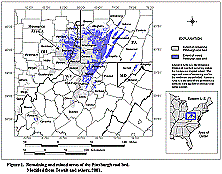
The Pittsburgh coal bed occurs in an area encompassing approximately 5,000 mi2 in the states of Ohio (OH), Pennsylvania (PA), West Virginia (WV), and Maryland (MD) (Ruppert and others, 1999a, 1999b; Tewalt and others, 2001) (fig. 1).Ā The Pittsburgh is the most extensively mined coal bed in the Appalachian Basin.Ā More coal has been mined from the Pittsburgh coal bed than any other coal bed in the U.S. and on an annual basis it remains the second largest producing coal bed in the U.S. (EIA, 2001a).Ā
|
|
|
Figure 1. Remaining and Mined Areas of the Pittsburgh Coal Bed. Modified from Tewalt and Others, 2001. (Click graph to view full size) |
The method to estimate available coal by mining method starts with the GIS layers developed by the Northern Appalachian Basin coal assessment team; adds layers needed for applying minability criteria; develops and applies minability criteria to determine the maximum amount of available coal; applies social and environmental restrictions to set aside some coal; and applies minimum mining block sizes to identify and put aside remaining contiguous coal that is too small and uneconomic for development.Ā The end result of applying the tool is a map and digital data that identify coal blocks in the remaining Pittsburgh coal bed available for mining by certain mining technologies.Ā
The USGS is making available a user’s guide that provides step-by-step instruction on the application of ArcView GIS and Spatial Analyst to estimate available coal (Watson, 2002).Ā Only a brief description of the application of the tool is provided in this paper.Ā Watson (2002) provides additional details on the use of the tool and reports additional example outcomes for the Pittsburgh coal bed.ĀĀĀĀĀĀĀ
The following GIS layers, compiled by the Northern Appalachian Basin coal assessment team, were used to characterize the location and quantity of the Pittsburgh coal:Ā (1) areal extent of original coal resources, (2) areal extent of remaining coal resources, (3) areal extent of mined areas, (4) isopach of coal bed thickness, and (5) structure contour, that is, elevation at the top of the coal bed (Tewalt and others, 1997).Ā New additional GIS grids for coal thickness, parting thickness, overburden thickness, and coal bed elevation were created specifically for use in the economic assessment of the Pittsburgh coal bed.
Various restrictions, based on social and environmental considerations defined by Federal and State regulations and industry practice, place some coal off-limits to mining (Carter and Gardner, 1989; Eggleston and others, 1990; Rohrbacher and others, 1993, 2000).Ā Features that are usually restricted from coal mining include urban areas, houses and buildings in populated places outside urban areas, streams, water bodies, parks, interstate highways, natural gas pipelines, and oil and gas wells.Ā The GIS data layers for urban areas, populated places, streams, water bodies, parks, and interstate highways were U.S. Geological Survey (USGS) digital line graph (dlg) coverages at 1:100,000 scale.Ā The natural gas pipeline coverage was obtained from the EIA (EIA, 1999).Ā The locations for oil and gas wells were obtained from a commercial source (Petroleum Information Corp., 1998).Ā Each protected feature and a buffer around its perimeter define the area where mining is prohibited (table 1).
Table 1.Ā GIS Restriction Layers Used to
Estimate Minable Coal in the Remaining Pittsburgh Coal Bed.
Buffers were added as part
of the analysis.
|
Layera |
Buffer |
Buffer (meters) |
Source |
|
Populated placesb |
300 |
96 |
Esric ArcData Online, 1999a |
|
Streams |
100 |
32 |
Esri ArcData Online, 1999a |
|
Water bodies |
100 |
32 |
Esri ArcData Online, 1999a |
|
Parks |
300 |
96 |
Esri Data and Maps, 1999b |
|
Urban areasd |
300 |
96 |
Esri Data and Maps, 1999b |
|
Interstate highways |
100 |
32 |
Esri Data and Maps, 1999b |
|
Natural gas pipelines |
100 |
32 |
EIAe (James Tobin), 1999 |
|
Oil and gas wells |
200 |
64 |
Petroleum Information Corp. 1998 |
|
a Boundaries for urban areas, populated places, streams, water bodies, parks, and interstate highways were developed from USGS dlg coverages at a 1:100,000 scale. USGS dlg coverages satisfy national map accuracy standards:ĀĀĀ http://mapping.usgs.gov/standards/index.html The natural gas pipeline coverage, developed mainly from industry data with incomplete documentation, has accuracy approximately equivalent to 1:100,000 dlg. Much of the coverage used USGS 1:24,000 hard copy maps as the base layer. The locations for oil and gas wells came from industry sources with unknown accuracy. However, because firms are required to file locations by government regulation, locations probably are reasonably accurate. ĀSee description of the Well History Control System at: http://geology.cr.usgs.gov/energy/resass/data_sources.html. b Populated places are towns and cities with population of 50,000 or less. c Esri - Environmental Systems Research Institute. d Urban areas is a geographic database of boundaries for urban areas with a populationĀgreater than 50,000.Ā e EIA - Energy Information Administration. |
|||
Five constraints were applied in the GIS analysis to delineate coal available for mining.Ā First, all remaining coal less than 12 in. in thickness was identified and removed from consideration for any mining application because coal this thin generally is uneconomical to mine.Ā Second, a 50 ft horizontal safety barrier was placed around historically mined areas and any remaining coal in the safety barrier was set aside by the analysis to simulate industry safety practices and regulations.Ā Third, GIS buffering and classification methods were applied to remove coal in restricted areas and buffers around restricted areas (Suffredini and others, 1994; Rohrbacher and others, 1993, 2000).Ā Fourth, technical considerations, for example, coal thickness, depth of overburden, and dip, specific to mining technologies were applied when the coal was delineated for those technologies.Ā Fifth, in order to meet operational efficiencies in mining, assessed coal blocks were required to have a minimum amount of coal.
The GIS analysis examined three alternate mining methods, first, surface mining, then longwall underground mining, and finally underground room and pillar mining using continuous miners.Ā At the end of each stage, the estimate of remaining coal was updated by removing the coal delineated for each mining method and the coal in 50-ft safety barriers extending around the delineated minable coal blocks.Ā A rolling revision guaranteed consistency in the amount of coal that fell into restricted areas, safety barriers, minable blocks, and remaining coal.ĀĀ As each mining technology was applied, it considered only the latest layer of calculated remaining coal.Ā Because longwall mining has high productivity and thus relatively low cost, the analysis assigned as much coal as possible to the longwall mining method.Ā In the last stage, all coal not previously allocated to restricted areas, safety barriers, surface minable blocks, or longwall minable blocks was evaluated to see if it could be mined by room and pillar methods using continuous miners.Ā
Each mining technology requires certain coal thickness ranges and minimum coal reserves for economically viable operations.Ā Past mining has split off some of the Pittsburgh coal into isolated blocks with tonnage too small to meet minimum reserve requirements for even a single economically viable mine.Ā Also, certain restrictions to mining, such as interstate highways and water bodies, fragment the coal into patches too small to meet minimum reserve requirements for viable mining.Ā Application of these conditions identified coal that was unsuitable for any type of commercial mining because its quantity was too small and coal in these categories was classified by the analysis as fragmented coal.
For each of the mining technologies shown in table 2 a mine life (column 6), run-of-mine coal production rate (column 3), mine production rate (column 4), and mining recovery factor (column 5) were specified to be consistent with current mining practices and mining equipment sizes (Rohrbacher, 2000a 2000b; Rohrbacher and others, 2000).Ā This information was used to estimate the minimum coal resource block needed for mining (column 7).Ā Each block of coal was required to have this minimum amount of coal resource (column 7) to be delineated as minable coal.Ā
Table 2.Ā Mine Model Configurations for the Pittsburgh Coal Mining Cost Analysis
|
(1) Mining Technology |
(2) Coal Thickness (in) |
(3) Run-of-mine Coal
Production |
(4) Mine Production
Rate Coal Only |
(5) Mining Recovery Factor |
(6) Mine Life |
(7) Minimum Resource
Tonnage Coal Only |
|
Surface |
||||||
|
Contour strip |
>12 <36 |
966,697 |
711,976 |
0.78 |
5 |
4.56a |
|
Contour strip |
>36 |
1,071,429 |
921,744 |
0.93 |
5 |
4.96a |
|
Small area |
>12 |
1,555,556 |
1,333,942 |
0.93 |
5 |
7.17a |
|
Auger |
>12 <36 |
87,500 |
71,017 |
0.30 |
5 |
1.18 |
|
Auger |
>36 |
175,000 |
150,427 |
0.30 |
5 |
2.51 |
|
Underground |
||||||
|
Longwall |
>42 <72 |
4,927,680 |
4,129,614 |
0.73 |
10 |
56.57 |
|
Longwall |
>72 <96 |
6,456,960 |
5,761,744 |
0.73 |
10 |
78.93 |
|
Longwall |
>96 |
6,082,500 |
5,301,150 |
0.75 |
10 |
70.68 |
|
Room and pillar mining with con- tinuous miners |
>24 <42 |
1,147,500 |
839,754 |
0.62 |
10 |
13.54 |
|
Room and pillar mining with con- tinuous miners. |
>42 <72 |
1,575,000 |
1,283,774 |
0.65 |
10 |
19.75 |
|
Room and pillar mining with con- tinuous miners. |
>72 <96 |
2,025,000 |
1,760,962 |
0.68 |
10 |
25.90 |
|
Room and pillar mining with con- tinuous miners |
>96 |
2,475,000 |
2,090,376 |
0.71 |
10 |
29.44 |
| aAs
explained in Watson and others (2002a), the minimum resource tonnage for
surface mines may be composed of disconnected coal resource areas, separated
by a maximum distance of two mi, that contain sufficient resources for
five years of mining. Notes: Run-of-mine coal production (column 3) includes coal (column 4) plus in-seam parting, and roof and floor dilution.Ā Mine sizes and recovery factors represent current practice for the Pittsburgh coal bed.Ā Source of columns 1 through 6:Ā Rohrbacher 2000a; 2000b; and Rohrbacher and others, 2000.Ā Column 7 derived as mine production rate (column 4) divided by the recovery factor (column 5) multiplied by mine life (column 6). |
||||||
Starting with the 15.6 bst estimated to remain in the Pittsburgh coal bed (Tewalt and others, 2001), the analysis applied the methods described above to place remaining Pittsburgh coal into three categories: (1) coal that is unavailable because it falls in an area where environmental and social considerations have high priority, (2) coal that is unsuitable for mining because technical minability requirements are not met, and (3) remaining, available coal by mining technology.
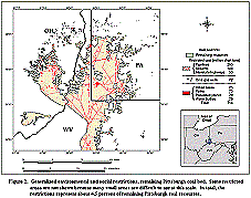
Environmental and Social Restrictions to Coal Mining. Environmental and social restrictions included natural gas pipelines, streams (surface mining only), interstate highways, oil and gas wells, urban areas, parks, populated places, and water bodies.Ā These features (augmented by buffers as appropriate) are responsible for setting aside about 714 mst of remaining Pittsburgh coal (fig. 2).ĀĀ Together, pipelines and streams account for about one-half of the restricted tonnage.Ā The other half of the restricted tonnage is spread over interstate highways, oil and gas wells, urban areas, populated places, parks, and water bodies.
|
| Figure 2. Generalized Environmental
and Social Restrictions, Remaining Pittsburgh Coal Bed. (Click graph to view full size) |
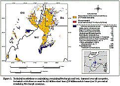
Technical Restrictions to Coal Mining. Technical restrictions include coal < 12 in. in thickness, coal in safety barriers, coal where the bed dips by more than 12 degrees (underground mines), coal where the surface slope exceeds 32 degrees (surface mines), coal not minable by any method, and fragmented coal.Ā Fragmented coal includes small segments of coal that have so few tons that they do not meet minimum resource requirements for even a single model mine (table 2).Ā It was estimated that 3.2 bst of remaining Pittsburgh coal would not meet technical requirements for minability.Ā Fragmented coal represented the bulk of the technical restrictions (2.3 bst).Ā Coal set aside by all other technical restrictions was estimated to be 0.9 bst (fig. 3).
|
| Figure 3. Technical Restrictions
to Coal Mining, Remaining Pittsburgh Coal Bed. (Click graph to view full size) |
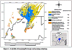
Available Coal by Mining Method. Out of the 15.6 bst estimated to remain in the Pittsburgh coal bed, 11.7 bst were estimated to be available for mining after subtracting 3.2 bst due to technical restrictions and 0.7 bst tons due to environmental and social restrictions.Ā The 11.7 bst of minable resources could potentially support mining operations at these levels: 7.6 bst from longwall mines, 3.5 bst from room and pillar continuous miner operations, and 0.6 bst from surface mining (which includes auger-mined coal).Ā Later, coal lost in mining and washing (estimated to be 3.9 bst) is subtracted from available coal resources (11.7 bst) to arrive at an estimate of 7.8 bst of recoverable Pittsburgh coal resources.Ā
The areas for longwall mining, extending across the thicker parts of the remaining Pittsburgh coal bed, comprise the largest acreage with remaining minable Pittsburgh coal (fig. 4).Ā Room and pillar methods using continuous miners would be applied to resources -- many of which adjoin the longwall-minable zones -- where overburden ranges from 100-600 ft.Ā Surface mining would occur at or near the outcrop.
|
| Figure 4. Availability of Remaining
Pittsburgh Coal by Mining Technology. (Click graph to view full size) |
GIS methods and geostatistical modeling were employed to estimate the sulfur content of remaining coal resources in the remaining contiguous Pittsburgh coal bed (resource area A, fig. 1).Ā The geostatistical software used was SPLUS and the ArcView plug-in for SPLUS (Mathsoft Inc., 1999).Ā The estimates were based upon 727 sample values of coal sulfur content spread unevenly across the spatial extent of both the remaining and mined portions of the Pittsburgh coal bed (Tewalt and others, 2001).Ā The analysis was designed to estimate coal sulfur content in the context of regional assessment.Ā
The main spatial statistical technique employed in the analysis of sulfur content was universal block kriging (Isaaks and Srivastava, 1989; MathSoft Inc., 1999).Ā The analysis was carried out on blocks, 2.7 mi on a side, representing coal tonnage of up to 70 mst, to adjust the analysis to a scale that generally matched the scale for delineating coal by mining method.Ā Because the sample data set is small relative to the size of the analyzed area and because it exhibits clustering, the data were adequate to support analysis only at a regional scale.Ā The estimates of the standard errors from the block kriging were relatively narrow compared to the ranges for point estimates, and, thus, the block-scale estimators proved to be useful indicators of generalized regional trends in sulfur content for the remaining Pittsburgh coal bed.Ā Like the regional-scale approach used to delineate minable coal, this analysis does not substitute for detailed mine and environmental assessments.
The estimates of average sulfur content by block were used to build a cumulative distribution of short tons of remaining coal in the Pittsburgh bed by average sulfur content.Ā Prediction error bars for the cumulative distribution were then built up from repeated simulations of the spatial correlation and regional trend in the sample data.Ā The stochastic model for the simulations was represented by the east-west trend and local variation (in coal sulfur content) captured in the block universal kriging model (Watson and others, 2001).Ā The simulations generated values in a geographical pattern that paired the fixed coal quantities with differing coal sulfur content distributions, to generate differing cumulative distributions for remaining Pittsburgh coal by sulfur content.Ā A large set of these alternate outcomes of the cumulative curve provided an estimate of the mean, upper, and lower limits of the cumulative curve for average sulfur content.Ā As illustrated below, this procedure was used to estimate a range of remaining Pittsburgh coal tonnages with average sulfur content equal to or less than a specified target average sulfur content.ĀĀĀ
Exploratory analysis of the sample data provided strong evidence that there was systematic spatial correlation between coal sulfur values at distances up to 24 mi.Ā To examine the data for spatial correlation, the sulfur content point sample data were grouped according to the distances separating them from other samples.Ā Then the average of the squared differences in coal sulfur contents for all the pairs grouped by a separation distance range was calculated.Ā When the sample pairs were located close to each other, they tended to have similar values and the calculated average of the squared difference was small compared to the squared-difference average when sample pairs were far apart.Ā This pattern indicated spatial correlation, implying that a new interpolated coal sulfur content value should be more similar in value to close-by known values than it should be to known values far away.Ā Block kriging, the spatial statistical method applied in the analysis, used this pattern of spatial correlation (translated into numerical estimates of spatial correlation that decline as distance to known sample points increases) to estimate sulfur content averages and standard errors.Ā The estimated block averages have the desirable statistical property of being “best linear unbiased estimators” or unbiased estimators with the lowest variance or most precision among all linear estimators (Cressie, 1993).Ā For example, kriged block averages have less variance than estimates derived as averages of the sample data or estimates that use inverse distance weights applied to the sample data.Ā And the kriged block averages are unbiased, that is, the kriging method does not systematically overestimate or underestimate the true coal sulfur content.Ā Estimates from alternate statistical methods, such as from numerical averages and inverse distance weighting, can be biased when the sample data are spatially correlated.Ā Because spatial correlation is often present in geologic data, standard statistical methods such as averages and inverse distance weights break down statistically, making it necessary to apply the more appropriate kriging methods (Cressie, 1993).Ā Watson and others (2002c and 2001) provide additional details on geostatistical methods applied to the Pittsburgh coal bed.
Estimates of average sulfur content are summarized by the contours shown in figure 5.Ā Each of the square gridded cells shown in fig. 5 occupies an area, 2.7 mi on a side, and could contain up to 70 mst of coal.Ā The sulfur contours are a prediction of the average sulfur content in blocks of that size.Ā In contrast, based upon a statistical model of point values (not the block average values from this study), new individual cores drilled in a given block can have sulfur values that cover a range of around 2 percentage points in sulfur above and below predicted point values.Ā But in the case of the block averages, high extreme values and low extreme values are averaged with other more-numerous intermediate values to form a block average.Ā Thus block averages ordinarily will have prediction errors for the average sulfur value of the block that are narrower than prediction errors for point estimates.Ā
 |
| Figure 5. Contours of Estimated
Average Sulfur Content (percent wt., as-received basis) for Blocks 2.7 mi
(4.34 km) on a Side, for the Remaining Un-mined Pittsburgh Coal Resources
in Resource Area A (see Figure 1). (Click graph to view full size) |
The block averages, of course, are estimates of the coal sulfur content averaged over entire blocks.Ā For regional analysis that type of average is of interest and utility.Ā The block average does identify areas where coal sulfur content could, on average, be relatively low.Ā Moreover, from the perspective of mine planning, mine operators are not looking to be assured that every bit of coal from a mine is low sulfur, rather that mined annual tonnage has a targeted average sulfur content. Given the large area of remaining Pittsburgh coal, the small set of coal sulfur sample values available to the analysis, the clustering of samples, and the concentration of many samples in mined areas (rather than in remaining resources), it is not surprising that the estimated standard error of the sulfur content for a new single coal sample is large.Ā But this finding is of little interest in the context of regional analysis where coal sulfur content averaged over an area potentially representing one or more large mining operations are more pertinent.ĀĀĀĀĀ
Figure 6 is a map of the standard deviations for the estimates of average sulfur content at the block level.Ā The most precise estimates (those with the smallest standard error) occur mainly for blocks in the areas where data samples are clustered.Ā The blocks with the smallest standard deviation (0.11 percent to 0.15 percent) are shown in dark blue.Ā There is a cluster of dark blue blocks near the southernmost extent of resource area A.Ā The relatively high precision is due, in large part, to the dense sampling pattern (not shown) in southernmost extent of resource area A.Ā In the northeast section of the coal field, the blocks with an average estimated sulfur content near 2 percent (see Figure 5) have an intermediate level of uncertainty; their standard deviations range from 0.42 to 0.69 percent.Ā As an example of interpretation, a block with an estimated average of 2.2 percent S and an estimated standard deviation of 0.5 percent S would have a 95 percent chance of having its true average sulfur content in the range between 1.2 percent and 3.2 percent S because the range is about ± 2 standard deviations at 95 percent probability.Ā Similar calculations can be performed for other blocks by combining estimates of average sulfur content and standard deviation from figs. 5 and 6, respectively.
|
| Figure 6. Uncertainty in the
Estimates of Block Average Sulfur Content for the Remaining Un-mined Pittsburgh
Coal Resources in Resource Area A (see Figure 1). (Click graph to view full size) |
Figure 7 combines the estimate of average sulfur content with an estimate of remaining coal tons (by blocks 2.7 mi on a side) to create a cumulative distribution of remaining tonnage by average sulfur content.Ā The upper and lower confidence limits shown in fig. 7 cover a 90 percent confidence range for average sulfur content, block by block.Ā Blocks at every level of predicted average sulfur content have wide variation in estimation precision.Ā Fig. 7 could provide a basis for prioritizing areas for additional core drilling to refine coal quality estimates.Ā For example, if it is thought that coal mining costs are relatively low for a particular block and the block has relatively low sulfur then mining companies or land brokers may find it worthwhile to undertake additional sampling to confirm the preliminary estimates provided by regional assessment.
|
| Figure 7. Cumulative Remaining
Unmined Coal Resources in Resource Area A (see Figure 1), in Order by Block
Average Sulfur Content, Including Upper and Lower 90 Percent Confidence
Levels. (Click graph to view full size) |
The spatial correlation and regional trend model was used to simulate other possible outcomes of the cumulative average sulfur content curve in order to estimate the expected cumulative curve and its lower and upper confidence limits (fig. 8).Ā Those estimates are useful for predicting the future availability of Pittsburgh coal by average sulfur content.Ā For example, fig. 8 indicates that there are between 3.1 and 7.4 bst, respectively, still remaining in resource area A at average sulfur contents between 1.4 percent and 3 percent, where the average and the limits are for the coal in blocks 2.7 mi on a side.Ā The expected estimate of available coal with block sulfur content of three percent or less is 4.9 bst.
|
| Figure 8. Cumulative Distributions
of Remaining Unmined Coal Resources by Average Sulfur Content, Block 2.7
mi (4.34 km) on a Side: Expected or Average, Upper 95 Percent Confidence
Level, and Lower 95 Percent Confidence Level Cumulative Distributions. (Click graph to view full size) |
The selection of an average sulfur content up to 3 percent in-situ (equal to about 2.3 lbs of S/mmBtu in-situ and 1.8 lbs of S/mmBtu post washing) is meant to highlight remaining Pittsburgh coal with economically attractive prospects for future development.Ā All of the remaining coal in the Pittsburgh coal bed has sulfur content above the Federal Clean Air Act sulfur compliance level of 0.6 lbs of S/mmBtu.Ā Nonetheless, currently there is an active market for Pittsburgh coal including coal with sulfur content up to about 4 lbs of S/mmBtu post washing, owing to relatively low mining cost (approximately $26/st or less for much of the coal), relatively low price, high calorific value, access to barge transportation, and close proximity to coal-fired power plants along the Ohio River and the Great Lakes, and in Ohio, Pennsylvania, New York, Massachusetts, New Hampshire, New Jersey, Delaware, Virginia, and Maryland.
Later, this analysis combines a cutoff of 2.3 lbs S/mmBtu in-situ and a coal price of $26/st as criteria for determining remaining coal with “high market potential.”Ā The tonnage meeting these criteria will be less than the 4.9 bst indicated in fig. 8 because the analysis imposes a mining cost of $26/st in addition to a sulfur content cutoff.
The analysis to estimate coal mining cost employed 12 mine models, designed to represent specific mining technologies within specific coal thickness ranges (table 2).Ā The estimates of tonnages available for mining by specific mining technologies, completed in an earlier step (discussed above), provided the initial data for application of the mine models.Ā
Each delineated block of available coal contains a total amount of coal that usually exceeds minimum requirements (shown in table 2) by several factors.Ā Also, each delineated block has its own amount of non-coal parting material based upon estimates from a GIS layer of parting thickness.Ā In any coal mining operation, the product that is mined includes pure coal, non-coal materials in partings, and, if it is an underground mine, rock mined from the floor and ceiling of the mine.Ā This volume of material—coal and non-coal material—is referred to as the run-of-mine coal volume.Ā Each mine model is designed to simulate a mining operation that processes a specific amount of run-of-mine coal.Ā
In the first stage of the analysis, each coal block delineated for mining is divided into smaller blocks containing run-of-mine volumes that match the design volumes for the mine models (as shown in column (3), table (2)).Ā Then this sub-block with its own distinctive volume of coal and non-coal material is “mined” by the model mine.Ā The mining costs for this operation are assigned to all the coal in the larger block.
The tons of product going to market are determined by the amount of material recovered when the coal is mined and further by the amount of material recovered when the coal is washed.Ā The model mine leaves behind some fraction of the coal in the delineated original block, for example, coal in pillars and barriers required to prevent cave-ins.Ā The percentage not recovered is a parameter set for each model mine according to mining technology.Ā
Also, because Pittsburgh coal normally is washed before it is shipped to market, the model mine includes coal washing.Ā In the simulated washing plant, different wash recovery percentages are applied to coal and non-coal material.Ā In the wash plant, a large fraction of the non-coal material is removed whereas most of the pure coal makes it through the wash plant and is included in the final market product.Ā These different wash recoveries are parameters set for each mine model.Ā
The different wash recoveries but constant total costs--as set by run-of-mine volumes--have important effects on coal price.Ā When a specific mine model was applied to estimate mining cost, it always handled the same total run-of-mine tonnage because each model mine has equipment, supplies, and manpower at the sizes required for each specific amount of run-of-mine production.Ā Assuming the application of the same mine model, a mine that encountered thick partings would incur the same costs as a mine with thin partings (because both would have the same run-of-mine tonnage) but the mine with thicker partings would generate a smaller amount of marketable product after coal washing and thus a higher cost per ton of coal to the market.
Each mine model contains a suite of equipment, manpower, and supplies representative of current engineering practice.Ā Equipment unit prices are taken from equipment lists (Gosling, 2000; Rohrbacher, 2000a) and updated to 2000 prices using the U.S. Bureau of Labor Statistics (2001) consumer price index for January 2000.Ā The model mines apply unit labor costs and unit supply costs as appropriate.Ā The mine models also assign costs for coal resource acquisition, site preparation, and site exploration.Ā The longwall mine models have configurations both for the longwall operations and for the development mining carried out by continuous miners in advance of longwall operations.Ā
A discounted cash flow (dcf) model with equipment phasing over the life of the mining operation was used to determine a coal price free-on-board (fob) that would return revenue equal to all discounted costs including a rate of return on investment.Ā The calculations in the dcf reflect all costs, taxes, reduction in tax liability from capital depreciation, and salvage value for equipment with remaining useful life. An after-tax real rate of return on investment of 12 percent was used in the calculations to estimate the opportunity or time-value cost for capital investment.Ā The costs in the model are in year-2000 dollars.Ā The mining costs or break-even fob minesite coal prices are representative of those seen in the coal market when capacity is maintained at levels sufficient to meet demand.
The coal mining cost model is a set of spreadsheets managed by a Visual Basic script.Ā The model is scheduled for release later this year (Watson and others, 2002d).Ā A detailed user’s guide (Watson and others, 2000b) will accompany the model.
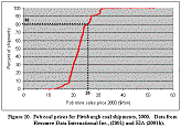
A cumulative distribution of the estimates (fig. 9) shows that about 83 percent of the 7.8 bst of remaining minable Pittsburgh coal resources are estimated to have mining costs of $26/st or less.Ā The estimated mining costs can be interpreted, alternately, as break-even fob mine sales prices.Ā These estimates agree closely with actual prices for recent shipments of Pittsburgh coal.ĀĀ Prices (spot and contract, fob minesite) in 2000 ranged from $9 to $52/st and 81 percent of 2000 shipments had an fob mine sales price of $26/st or less (fig. 10).
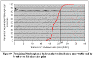
|
| Figure 9. Remaining Pittsburgh
Coal Bed Cumulative Distribution, Recoverable Coal by Break-even fob Mine
Sales Price. (Click graph to view full size) |
Each of the assessed blocks was assigned
an id to aid in determining remaining coal with the highest market potential.Ā
The geostatistical methods described earlier provided an estimate of average
sulfur content.Ā Average Btu/lb for the coal in each block also was estimated,
as was the average coal thickness.Ā The assessment results are summarized in
table 3.
|
| Figure 10. Fob Coal Prices for
Pittsburgh Coal Shipments, 2000. Data from Resource Data International Inc.,
(2001) and EIA (2001b). (Click graph to view full size) |
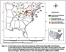
Pittsburgh coal is the second most produced coal bed in the U.S. (EIA, 2001a).Ā Pittsburgh coal is shipped primarily to electric power plants that are located close to the coal fields or can be reached by water transport.Ā In 2000, Pittsburgh coal was delivered to many close-by power plants in Ohio, Pennsylvania, New York, Massachusetts, New Hampshire, New Jersey, Delaware, Virginia, and Maryland.ĀĀ Also, Pittsburgh coal mines supplied power plants along the Ohio River, on the Great Lakes, and as far away as Tampa, FloridaĀ (fig. 11).Ā
About 47 percent of Pittsburgh coal shipments are going to power plants with SO2 scrubbers (Resource Data International Inc., 2001 and EIA, 2001b). ĀEven though its coal sulfur content and calorific values place Pittsburgh coal well above the Clean Air Act compliance level of 0.6 lbs of S/mmBtu, Pittsburgh coal is expected to remain competitive.Ā
Table 3.Ā Assessment
Results:Ā Prospective Mining Methods, Mining Costs, Sulfur, Btu, and Coal Thickness
for Remaining, Recoverable Pittsburgh Coal Resources
|
Coal Area ID |
Recoverable
Coal Resources (million short tons)
|
Break-even fob Mine Sales Price ($/ton) |
Average Sulfur Content (lbs of S/mmBtu) |
Average Calorific Value (Btu/lb) |
Average Coal Thickness (in.) |
| Coal areas assessed for undergound mining by longwall methods | |||||
|
101 |
101.012 |
$18.24 |
2.43 |
13,215 |
105 |
|
102 |
69.995 |
$18.29 |
2.12 |
13,381 |
104 |
|
103 |
104.425 |
$18.89 |
2.68 |
13,099 |
85 |
|
104 |
163.290 |
$20.56 |
2.58 |
12,820 |
80 |
|
105 |
122.802 |
$20.69 |
1.70 |
13,471 |
82 |
|
106 |
109.450 |
$20.79 |
2.64 |
13,341 |
86 |
|
107 |
124.144 |
$20.87 |
2.36 |
13,284 |
88 |
|
108 |
93.287 |
$20.96 |
2.00 |
13,525 |
86 |
|
109 |
88.668 |
$20.98 |
3.14 |
12,863 |
66 |
|
110 |
104.217 |
$21.01 |
2.28 |
13,106 |
77 |
|
111 |
122.328 |
$21.02 |
2.20 |
13,063 |
78 |
|
112 |
98.742 |
$21.33 |
2.79 |
13,079 |
66 |
|
113 |
146.308 |
$21.35 |
2.49 |
12,722 |
81 |
|
114 |
66.185 |
$21.36 |
1.83 |
13,120 |
75 |
|
115 |
137.925 |
$21.39 |
2.82 |
13,052 |
67 |
|
116 |
150.070 |
$21.42 |
2.31 |
12,968 |
68 |
|
117 |
102.463 |
$21.44 |
2.56 |
13,325 |
83 |
|
118 |
145.083 |
$21.48 |
2.70 |
13,106 |
86 |
|
119 |
129.242 |
$21.48 |
2.19 |
13,195 |
84 |
|
120 |
70.866 |
$21.50 |
2.35 |
13,087 |
78 |
|
121 |
123.755 |
$21.53 |
2.57 |
13,038 |
66 |
|
122 |
135.938 |
$21.63 |
2.66 |
13,058 |
67 |
|
123 |
78.399 |
$21.94 |
2.18 |
13,170 |
69 |
|
124 |
43.628 |
$21.97 |
2.69 |
13,311 |
65 |
|
125 |
115.697 |
$22.18 |
2.90 |
13,032 |
66 |
|
126 |
91.562 |
$22.84 |
3.46 |
12,727 |
64 |
|
127 |
61.991 |
$23.01 |
2.58 |
13,054 |
76 |
|
128 |
73.551 |
$23.14 |
3.34 |
12,627 |
63 |
|
129 |
89.640 |
$23.51 |
3.35 |
12,798 |
79 |
|
130 |
161.730 |
$24.08 |
1.47 |
13,359 |
66 |
|
131 |
153.518 |
$24.18 |
3.48 |
12,641 |
59 |
|
132 |
117.555 |
$24.21 |
2.84 |
12,648 |
56 |
|
133 |
62.070 |
$24.23 |
1.95 |
13,396 |
65 |
|
134 |
69.356 |
$24.32 |
2.74 |
12,535 |
57 |
|
135 |
70.887 |
$24.58 |
3.47 |
12,306 |
56 |
|
136 |
147.134 |
$24.72 |
1.68 |
13,086 |
64 |
|
137 |
110.340 |
$24.84 |
2.02 |
13,176 |
61 |
|
138 |
117.151 |
$24.85 |
2.26 |
13,031 |
56 |
|
139 |
139.977 |
$25.02 |
1.57 |
13,275 |
61 |
|
140 |
154.080 |
$25.22 |
1.61 |
13,155 |
63 |
|
141 |
98.690 |
$25.57 |
3.52 |
12,847 |
56 |
|
142 |
160.093 |
$26.13 |
4.20 |
12,253 |
60 |
|
143 |
59.289 |
$26.47 |
4.12 |
12,469 |
49 |
|
144 |
155.501 |
$26.74 |
3.41 |
12,350 |
57 |
|
145 |
84.458 |
$26.75 |
2.64 |
13,348 |
56 |
|
146 |
86.517 |
$27.12 |
4.08 |
12,203 |
52 |
|
147 |
116.184 |
$28.27 |
3.91 |
12,464 |
55 |
| Subtotal tons:ĀĀĀ 5,129.195 | |||||
|
Coal areas assessed for underground mining by continuous mining methods |
|||||
|
201 |
30.077 |
$19.22 |
1.95 |
13,556 |
91 |
|
202 |
51.172 |
$19.65 |
2.61 |
13,376 |
90 |
|
203 |
42.232 |
$19.76 |
2.73 |
13,391 |
103 |
|
204 |
40.743 |
$21.56 |
2.66 |
13,289 |
85 |
|
205 |
38.300 |
$21.61 |
1.20 |
13,508 |
83 |
|
206 |
20.916 |
$21.72 |
2.26 |
13,404 |
87 |
|
207 |
25.126 |
$21.76 |
2.63 |
13,402 |
85 |
|
208 |
44.099 |
$21.77 |
2.59 |
13,424 |
84 |
|
209 |
35.936 |
$21.80 |
2.74 |
13,349 |
82 |
|
210 |
27.961 |
$21.84 |
2.11 |
13,485 |
81 |
|
211 |
54.995 |
$21.94 |
2.16 |
13,518 |
86 |
|
212 |
43.319 |
$22.05 |
1.38 |
13,479 |
80 |
|
213 |
20.060 |
$22.10 |
2.89 |
13,103 |
82 |
|
214 |
47.164 |
$22.11 |
2.69 |
13,420 |
86 |
|
215 |
27.796 |
$22.12 |
1.41 |
13,376 |
79 |
|
216 |
30.413 |
$22.20 |
2.46 |
13,094 |
80 |
|
217 |
53.614 |
$22.33 |
2.64 |
13,402 |
87 |
|
218 |
25.681 |
$22.42 |
2.66 |
13,479 |
84 |
|
219 |
46.517 |
$22.43 |
2.62 |
13,145 |
78 |
|
220 |
27.658 |
$22.72 |
1.92 |
13,290 |
82 |
|
221 |
45.143 |
$22.96 |
3.18 |
12,958 |
66 |
|
222 |
54.894 |
$23.21 |
2.90 |
13,063 |
77 |
|
223 |
49.868 |
$23.35 |
1.34 |
13,365 |
79 |
|
224 |
51.525 |
$23.45 |
2.74 |
13,345 |
82 |
|
225 |
46.522 |
$24.22 |
3.75 |
12,621 |
77 |
|
226 |
19.515 |
$24.56 |
3.66 |
12,643 |
68 |
|
227 |
15.379 |
$24.61 |
1.08 |
13,191 |
66 |
|
228 |
35.282 |
$24.81 |
2.87 |
13,504 |
58 |
|
229 |
33.357 |
$24.84 |
3.78 |
12,501 |
64 |
|
230 |
21.940 |
$24.84 |
1.04 |
13,242 |
66 |
|
231 |
20.871 |
$24.96 |
3.13 |
12,262 |
59 |
|
232 |
39.027 |
$25.00 |
2.92 |
13,338 |
55 |
|
233 |
32.235 |
$25.04 |
2.92 |
12,525 |
60 |
|
234 |
17.878 |
$25.37 |
3.58 |
11,973 |
49 |
|
235 |
42.080 |
$25.40 |
2.41 |
12,956 |
58 |
|
236 |
39.374 |
$25.43 |
2.00 |
12,983 |
59 |
|
237 |
26.674 |
$25.46 |
1.39 |
13,098 |
59 |
|
238 |
26.315 |
$25.50 |
2.16 |
12,982 |
59 |
|
239 |
32.518 |
$25.51 |
1.67 |
12,996 |
62 |
|
240 |
24.214 |
$25.51 |
3.43 |
12,287 |
57 |
|
241 |
12.950 |
$25.58 |
3.14 |
12,433 |
37 |
|
242 |
21.154 |
$25.80 |
3.29 |
12,530 |
63 |
|
243 |
24.351 |
$25.85 |
2.75 |
12,394 |
59 |
|
244 |
20.614 |
$25.85 |
3.51 |
12,263 |
51 |
|
245 |
32.014 |
$25.94 |
3.29 |
12,545 |
53 |
|
246 |
24.309 |
$26.11 |
3.65 |
12,287 |
50 |
|
247 |
30.524 |
$26.13 |
3.56 |
12,317 |
53 |
|
248 |
38.305 |
$26.13 |
3.73 |
12,146 |
51 |
|
249 |
30.890 |
$26.19 |
2.97 |
12,691 |
56 |
|
250 |
14.602 |
$26.22 |
2.68 |
13,359 |
60 |
|
251 |
16.654 |
$26.24 |
2.97 |
12,303 |
57 |
|
252 |
32.874 |
$26.27 |
2.80 |
13,261 |
59 |
|
253 |
39.128 |
$26.49 |
3.82 |
12,128 |
50 |
|
254 |
26.329 |
$26.52 |
3.78 |
12,424 |
49 |
|
255 |
33.275 |
$26.54 |
2.83 |
12,556 |
61 |
|
256 |
42.223 |
$26.61 |
2.75 |
13,011 |
63 |
|
257 |
42.821 |
$27.08 |
1.38 |
13,379 |
59 |
|
258 |
42.975 |
$27.36 |
1.27 |
13,352 |
59 |
|
259 |
36.589 |
$27.65 |
3.81 |
12,610 |
37 |
|
260 |
31.281 |
$27.91 |
3.76 |
12,596 |
54 |
|
261 |
17.591 |
$28.12 |
3.55 |
12,502 |
57 |
|
262 |
30.593 |
$28.37 |
2.93 |
12,077 |
57 |
|
263 |
28.328 |
$28.90 |
2.54 |
13,223 |
34 |
|
264 |
21.609 |
$30.16 |
3.60 |
12,129 |
34 |
|
265 |
32.581 |
$30.22 |
1.34 |
13,273 |
34 |
|
266 |
16.676 |
$30.73 |
2.69 |
13,124 |
33 |
|
267 |
20.811 |
$33.84 |
2.75 |
12,306 |
30 |
| Subtotal tons:ĀĀĀ 2,170.439 | |||||
|
Coal areas assessed for mining by surface methods |
|||||
|
301 |
39.986 |
$21.30 |
2.44 |
12,239 |
61 |
|
302 |
8.913 |
$21.71 |
1.44 |
13,118 |
104 |
|
Ā 303* |
30.515 |
$21.75 |
1.86 |
13,582 |
87 |
|
Ā 304* |
68.310 |
$21.97 |
2.52 |
13,373 |
69 |
|
Ā 305* |
37.282 |
$22.08 |
2.74 |
13,355 |
58 |
|
306 |
10.299 |
$22.23 |
1.96 |
13,044 |
50 |
|
Ā 307* |
26.865 |
$22.24 |
1.94 |
13,341 |
65 |
|
Ā 308* |
50.003 |
$23.85 |
3.55 |
12,197 |
53 |
|
Ā 309* |
95.141 |
$24.01 |
1.33 |
13,397 |
60 |
|
310 |
17.443 |
$24.11 |
2.42 |
12,783 |
65 |
|
311 |
12.305 |
$25.48 |
2.26 |
12,388 |
58 |
|
312 |
44.719 |
$25.52 |
2.17 |
12,265 |
66 |
|
313 |
11.199 |
$27.39 |
2.68 |
13,143 |
26 |
| Subtotal tons:ĀĀĀĀĀĀĀ 452.979 | |||||
| Total tons:ĀĀĀĀĀĀĀĀĀ 7,752.613 | |||||
 |
|
Figure 11. Coal-fired Power Plants that Received Shipments
of Pittsburgh Coal in 2000.
|
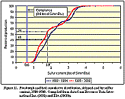
Estimates can be made of the quantity and location of that part of the remaining Pittsburgh coal resource, which could be mined at or below some specified mining cost and average sulfur content (lbs of S/mmBtu).Ā To complete these estimates, limits on mining cost ($26/st) and average sulfur content (2.3 lbs of S/mmBtu in-situ; approximately 1.8 lbs of S/mmBtu post washing) were set based on the sulfur content and prices for recent shipments of Pittsburgh coal, and general market conditions.Ā Because mining costs for low sulfur western coal are continuing to fall (EIA, 2000), companies operating in the Pittsburgh coal bed will have to target the lowest cost part of the Pittsburgh coal resource for future operations, to remain competitive.Ā A mining cost of $26/st or less represents a reduction (compared with the current price range) in the distribution of future Pittsburgh mining costs and prices, needed to keep Pittsburgh coal competitive with other coals and alternate fuels.Ā The national SO2 cap set under the Federal law requires higher abatement levels to stay under the cap.Ā The stock of banked SO2 allowances provides for some short term relaxation on abatement effort but once banked allowances are sold off and demand growth leads to more fossil fuel utilization, then abatement effort will have to be expanded.Ā This condition would imply a narrower spread in the sulfur content of coal mined from the Pittsburgh coal bed.Ā Recent shipments have contained coal with sulfur contents as high as 4 lbs of S/mmBtu post washing (fig. 12).Ā The chosen limit at 2.3 lbs of S/mmBtu in-situ (about 1.8 lbs of S/mmBtu, post washing) would narrow the distribution of sulfur content for the future needed to keep the Pittsburgh coal resource competitive.
|
| Figure 12. Pittsburgh Coal Bed Cumulative Distribution, Shipped Coal
by Sulfur Content, 1989-2000. (Click graph to view full size) |
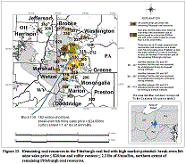
The minable blocks of remaining Pittsburgh coal that have prices and sulfur contents at or below $26/st and 2.3 lbs of S/mmBtu in-situ, respectively, were identified using the data in table 3.Ā Because each of the minable blocks meeting these limits was analyzed by GIS methods, the location of the coal can be shown (figs. 13 and 14).Ā At these mining cost and sulfur limits, minable Pittsburgh coal resources are estimated to total 2.4 bst or 15 percent of remaining Pittsburgh coal resources.
Most of this high-market-potential minable Pittsburgh coal is located in Greene and Washington Counties, Pennsylvania, (995 and 690 mst, respectively).Ā Monongalia, Marion, Kanawha, and Marshall Counties, West Virginia were estimated to have 200, 131, 111, and 85 mst, respectively.Ā Another 8 counties where the coal was estimated to be relatively small in quantity account for another 179 mst.
|
| Figure 13. Remaining Coal Resources in the Pittsburgh Coal Bed with
High Market Potential. (Click graph to view full size) |
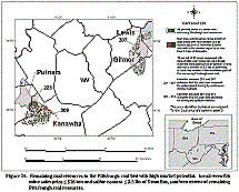
Out of the 2.4 bst, it was estimated that 70 percent would be mined by the longwall method, 20 percent by the room and pillar continuous miner method, and 10 percent by surface methods.Ā Pennsylvania has most (70 percent) of the 2.4 bst of remaining Pittsburgh coal resources classified as having high market potential, followed by West Virginia (28 percent) and Ohio (2 percent). ĀĀĀĀĀĀĀĀĀ
|
| Figure 14. Remaining Coal Resources in the Pittsburgh Coal Bed With
High Market Potential. (Click graph to view full size) |
Assuming a continuation of annual production from the Pittsburgh coal bed at the current rate of about 80 mst (EIA, 2001a), these recoverable resources (2.4 bst) could support production for about another 30 years.Ā Using the probability ranges developed for coal sulfur content, the remaining production life for the Pittsburgh coal bed is estimated to range from 19 to 45 years.
Sound analysis is predicated on the availability of data that has high quality and density sufficient for its application.Ā Certainly, the coal quantity and quality data being made available by the USGS through its latest national coal assessment program meet this standard.Ā Furthermore, the USGS is providing the data as GIS layers, further enhancing its use in future analysis.Ā
Three analytic tools also have been developed under USGS sponsorship:Ā (1) a tool to estimate coal available for mining by specific mining technologies, (2) a tool to estimate coal quality such as sulfur and heat content, and (3) a tool to estimate future coal mining costs.Ā The assessment data can be used with these analytic tools to address important issues related to regional coal availability, recoverability, and future prospects for production, as illustrated herein.
To support additional analysis, documentation for each of the tools is being made available by the USGS (Watson, 2002; Watson and others, 2002a; 2002b; 2000c; and 2002d).Ā Applications of the tools to other coal beds could be useful in determining future mining costs and the potential contribution of coal to regional and national energy mixes.ĀĀ ĀĀĀ
Carter, M. D. and Gardner, N. K., 1989, An assessment of coal resources available for development:Ā Reston, Va., U.S. Geological Survey Open-File Report 89-362, 53 p.
Carter, M.D., Rohrbacher, T.J., Teeters, D.D., Scott, D.C., Osmonson, L.M., Weisenfluh, G.A., Loud, E.I., Sites, R.S., Axon, A.G., Wolfe, M.E., and Lentz, L.J., 2001, Coal availability, recoverability, and economic evaluations of coal resources in the northern and central Appalachian basin coal regions: Reston, Va., U.S. Geological Survey Professional Paper 1625C, Chapter J, CD-ROM.
Cressie, N., 1993, Statistics for spatial data: New York, John Wiley, 900 p.
Eggleston, J.R., Carter, M.D., and Cobb, J.C., 1990, Coal resources available for development–a methodology and pilot study: Reston, Va., U.S. Geological Survey Circular 1055, 15 p.
Energy Information Administration (EIA), 1999, Natural gas pipeline digital spatial database:Ā Washington D.C., U.S. Department of Energy, available from james.tobin@eia.doe.gov.
Energy Information Administration (EIA), 2000, Annual energy outlook 2001 with projections to 2020: Washington, D.C., U.S. Department of Energy, DOE/EIA-0383(2001), 258 p.
Energy Information Administration (EIA), 2001a, Coal industry annual 2000 preliminary tables: Washington, D.C.,ĀU.S. Department of Energy, available at: http://www.eia.doe.gov/cneaf/coal/page/database.html.Ā
Energy Information Administration (EIA), 2001b, EIA form 7A database: Washington, D.C., U.S. Department of Energy, available at http://www.eia.doe.gov/cneaf/coal/page/database.html.
Esri Inc., 1999a, ArcData OnLine, Census 95 Tiger Data: [available from http://www.Esri.com/data/index.html].
Esri Inc., 1999b, Esri Data and Maps: Redlands, Ca., Esri (5 CD set).
Gosling, B.B. (compiler), 2000, Canada and United States taxes, in Schumacher, O.L. ed. Mining cost service: Spokane, Washington, Western Mine engineering, Inc., vol. 2. p. TA1-TA76.
ICF, Inc., 1980, Coal and electric utilities model documentation: Washington, D.C., ICF, Inc., 271 p.
Isaaks, E. and Srivastava, R., 1989, An introduction to applied geostatistics: New York, Oxford University Press, 561 p.
Kolstad, C.D., Hinman, G., Morris, G., Palmer, R., and Pendley, R., 1978, A minimum cost linear programming model for regional assessment of energy extraction, transportation, and use:Ā Los Alamos, New Mexico, Los Alamos National Laboratory Report LA-6689-MS.
MathSoft Inc., 1999, S+SpatialStats version 1.5: Seattle, WA., MathSoft, Inc., 84 p.
Petroleum Information Corp., 1998 [ current as of December 31, 1997],Ā Well history control system: Littleton, Co., Petroleum Information Corp., [database available from Petroleum Information Corp., 4100 East Dry Creek Road, Littleton, CO 80122].
Nordhaus, W.D., 1979, The efficient use of energy resources: New Haven, Connecticut, Yale University Press, 161 p.
Resource Data International, Inc., 2001, COALdat database: Boulder, Co., Resource Data International, Inc. [database available from Resource Data International Inc., 1320 Pearl Street, Suite 300, Boulder, CO 80302].
Rohrbacher, T.J., 2000a, Written communications based on proprietary data developed and interpreted by Foothills Engineering, under contract no. 99CRSA1075 U.S. Geological Survey, 2000, for Coalval mine models.
Rohrbacher, T.J., 2000b, Written communications with the coal industry and academia used to validate Coalval update statistics, 2000.
Rohrbacher, T.J., Teeters, D.D., Sullivan, G.L., and Osmonson, L.M., 1993, Coal Resource recoverability, a methodology: Washington, D.C., U.S. Bureau of Mines, Information Circular 9368, [available from http://energy.er.usgs.gov/products/papers/C9368/intro.htm].
Rohrbacher, T.J., Molnia, C.L., Osmonson, L.M., Carter, M.D., Eakins, W., Hoffman, G.K., Tabet, D.E., Schultz, J.E., Scott, D.C., Teeters, D.D., Jones, G.E., Quick, J.C., Hucka, B.P., and Hanson, J.A., 2000, Coal availability, recoverability, and economic evaluations of coal resources in the Colorado Plateau: Colorado, New Mexico, and Utah: U.S. Geological Survey Professional Paper 1625-B, Chapter F, CD-ROM.
Ruppert, L.F., Tewalt, S.J., Bragg, L.J., and Wallack, R.N., 1999a, A digital resource model of the upper Pennsylvanian Pittsburgh coal bed, Monongahela Group, Northern Appalachian Basin coal region, USA:Ā International Journal of Coal Geology, v. 4, p. 3-24.
Ruppert, L.F., Tewalt, S.J., Bragg, L.J., and Wallack, R.N., 1999b, Digital assessment of northern and central Appalachian basin coals:Ā Mining Engineering, Oct. 1999, p. 37-43.
Suffredini, C.D., Plis, M.N., Rohrbacher, T.J., and Teeters, D. D., 1994, COALVAL 2.0, A prefeasibility software package for evaluating coal properties using Lotus 1-2-3, release 3.1: Denver, Co., U.S. Bureau of Mines Open-File Report 35-94.
Tewalt, S.J., Ruppert, L.F., Bragg, L.J., Carlton, R.W., Brezinski, D.K., and Wallack, R.N., 1997, Map showing thickness contours of the Pittsburgh coal bed in Pennsylvania, Ohio, West Virginia, and Maryland; digitally compiled by Tewalt, S., Ruppert, L., Wallack, R., and Weiss, E.:Ā U.S. Geological Survey Open-File Report 97-748, scale 1:425,000, 1 sheet, [available from
Tewalt, S.J., Ruppert, L.F., Bragg, L.J., Carlton, R.W., Brezinski, D., Wallack, R.N., and Butler, D.T., 2001, A digital resource model of the upper Pennsylvanian Pittsburgh coal bed, Monongahela Group, Northern Appalachian Basin coal region, U.S.A.: Reston, Va., U.S. Geological Survey Professional Paper 1625C, Chapter C, CD-ROM.
U.S. Bureau of Labor Statistics, 2001, Consumer price index updates for January 2000, available at http://www.bls.gov/cpi.
U.S. Department of Energy (Energy Information Administration), 1984, National coal model (version 5): Washington, D.D., U.S. Government Printing Office, 90p.
U.S. Geological Survey, 1999, 1999 resource assessment of selected tertiary coal beds and zones in the northern rocky mountains and great plains region:Ā Reston, Va., U.S. Geological Survey Professional Paper 1625A, CD-ROM.
U.S. Geological Survey, 2000, Geologic assessment of coal in the Colorado Plateau:Ā Arizona, Colorado, New Mexico, and Utah:Ā Reston, Va., U.S. Geological Survey Professional Paper 1625B, CD-ROM.
U.S. Geological Survey, 2001, 2000 resource assessment of selected coal beds and zones in the northern and central Appalachian basin coal regions:Ā Reston, Va., U.S. Geological Survey Professional Paper 1625C, CD-ROM.
Watson, W.D., Medlin, A., Krohn, K., Brookshire, D., and Bernknopf, R., 1991, Economic effects of western Federal land use restrictions on U.S. coal markets: Reston, Va.,:Ā U.S. Geological Survey Circular 1042, 197 p.
Watson, W.D., Ruppert, L. F., Bragg, L.J., and Tewalt, S.J., 2001, A geostatistical approach to predicting sulfur content in the Pittsburgh coal bed:Ā International Journal of Coal Geology, v. 48, p. 1-22.
Watson, W.D., 2002, ArcView coal evaluation users guide, U.S. Geological Survey Professional Paper, forthcoming.
Watson, W.D., Attanasi, E., Freeman, P., Ruppert, L.F., Tewalt, S.J., Bragg, L.J., and Rohrbacher, T., 2002a, Mining cost and coal quality estimates for coal remaining in the Pittsburgh Coal bed:Ā a pilot economic study using the U.S. Geological Survey’s national coal resource assessment data, U.S. Geological survey Professional Paper, forthcoming.
Watson, W.D., Attanasi, E., Freeman, P., Ruppert, L.F., Tewalt, S.J., Bragg, L.J., and Rohrbacher, T., 2002b, Appendix A:Ā methods to derive coal resource cost curves, U.S. Geological Survey Professional Paper, forthcoming.
Watson, W.D., Attanasi, E., Freeman, P., Ruppert, L.F., Tewalt, S.J., Bragg, L.J., and Rohrbacher, T., 2002c, Appendix B:Ā geostatistical methods to estimate sulfur content, U.S. Geological Survey Professional Paper, forthcoming.
Watson, W.D., Attanasi, E., Freeman, P., Ruppert, L.F., Tewalt, S.J., Bragg, L.J., and Rohrbacher, T., 2002d, Appendix C:Ā spreadsheets, data, and programs used to estimate mining costs, U.S. Geological Survey Professional Paper, forthcoming.
Author Information:
William D. Watson
Team Leader, Coal Information Team
Energy Information Administration
U.S. Department of Energy
1000 Independence Ave. SW
Washington, D.C. 20585
Tel:Ā (202) 287-1971
Fax:Ā (202) 287-1934
E-mail:Ā william.watson@eia.doe.gov