For over a decade in Japan, about one thousand cases of illegal dumping have been reported and out of about 400 thousand tons are the total annual industrial waste1. In addition, it is supposed that many other cases of domestic illegal dumping have been left unreported. Local governments confronting such illegal dumping issues have been taking pains to work out countermeasures.
An important approach to environmental protection as a familiar subject matter of each region is to promote the enforcement of administrative policies assumingthe residents' improved awareness and deliberate participation. To understand visible changes to the environment such as illegal dumping, in particular, it is urgently needed to create a mechanism for monitoring through close collaboration between the residents and administration.
The progress in information technology (IT) in recent years has extended the environment surrounding geographic information systems (GISs) from professional spatial analysis tools conventionally used by research institutes and technical consultants to familiar information utilization tools using general PCs. The "e-japan" Strategy formulated by the Japanese Government in 2001 advocates the introduction of IT to the administration, aiming at the establishment of an infrastructure for the world's most advanced communications environment by 2005. "GIS Action Program 2002-2005" based on the e-japan Strategy includes the plan for effectively using GISs in various governmental fields to streamline administration and to provide higher-quality administrative services.
This paper introduces GIS-based support systems for the reduction of illegal dumping as preventive measures by local governments to study the effects of using GISs and thecooperation between authorities and communities.
A GIS can be applied to an environment monitoring system by getting information plotted such as images and location data collected by portable terminals (PDAs) and digital cameras. A system that collects environment information via the Internet and loads it onto a GIS can be expected to serve as a strong aid for residents or an NGO in starting activities for environmental protection.
Of all administrative measures against illegal dumping, patrolling and illegal dumping database management/analysis seems to be supported effectively by the use of GIS. From this standpoint, we proposed the following three GIS-based systems for a certain administrative organizations affected by illegal dumping:
(1) Patrol support system using ArcPAD
(2) Report support system using ArcIMS
(3) Illegal dumping analysis support system using ArcGIS
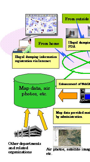
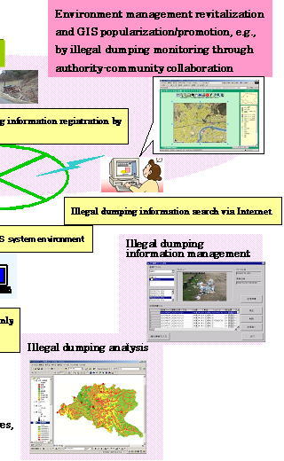
These GIS-based systems for supporting illegal dumping prevention are conceptually illustrated in Figure 1.
Figure 1 Concept of theadministrative systems
The following sections introduce GIS application points and describe the proposed systems, focusing on the current operations by the local government affected by illegal dumping.
2.1 Patrol Support System Using ArcPAD
A major activity for preventing illegal dumping is patrolling by administrative staff. Each case of illegal dumping discovered during a patrol is recorded on a field book or topographic map.
For conventional patrolling, it is important to prepare the map of the scheduled area and arranging the results of investigation as well as to collect site information. We developed a system for collecting and recording information using a PDA to improve work efficiency during patrolling. The PDA is utilized to display the current position obtained from a GPS and ArcPAD6 is used to display the registered map. We also provided the system with a feature of transmitting site photos taken by a digital camera, notes taken by administrative staff, and other information collected directly to the server by mobile data communication via HTTP, thereby offering a mechanism for supporting the arrangement of investigation results.
2.2 Report Support System Using ArcIMS
Illegal dumping is discovered in many cases by the reports on grievances from ordinary residents. Note, however, illegal dumping information from residents is given mainly by telephone and in many cases it takes time to locate the site and identify the conditions. It is therefore important for the administration covering the wide area to accurately transmit illegal dumping information collected at the window to the section in charge as soon as possible. We created a Web site using ArcIMS3.1 to develop a system for registering the discovered dumping sites and their conditions directly via the Internet.
2.3 Analysis Support System Using ArcGIS
For efficient patrolling, it is important to specify those districts in which illegal dumping seems to occur at higher possibility, which are currently spotted largely depending on the experience of administrative staff. Using a GIS, we analyzed the districts in which illegal dumping is apt to occur, through the records of illegal dumping sites discovered in the past and the questionnaires about investigation experience of administrative staff. From the results of this analysis, we created an illegal dumping hazard map using Spatial Analyst of ArcGIS8.1.
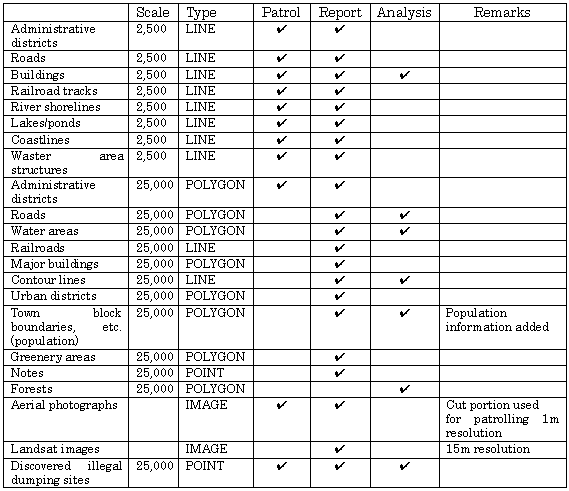
The following pieces of map data are used for the systems.
Table 1 Map data list
4.1 Effects of the Patrol Support System
Using the patrol support system, an administrative official goes to formerly discovered illegal dumping sites and enters the conditions of the past site using a PDA.
After arriving the site, the official first inputs the field investigation point using the PDA. When the official enters the point, the current location detected by the GPS is displayed on the ArcPAD screen. According to the current location on the screen, the official inputs the illegal dumping point using a stylus pen. The illegal dumping point is entered manually because one cannot trespass on illegal dumping site and might have to enter the points near the site. The official inputs the amount and type of illegally dumped waste along with the location information.
After entering information at each site, the official transmits the data using the PDA. The data is transferred to the server via PHS mobile phones. The transferred data is registered in the map so that staff can share the information by browsing over the Internet.
Compared to a conventional paper-based recording method, key benefits of the patrol support system are that the PDA displays the current location detected by the GPS and that the aerial photograph is displayed, making it easy to locate the specific dumping point. Through the field test, we found that the time for arranging materials in order, previously requiring tens of minutes, was reduced 70% as input data could be transmitted directly to and recorded in the system. The reduction in time means improvement in operation that cannot be provided by the conventional input method.
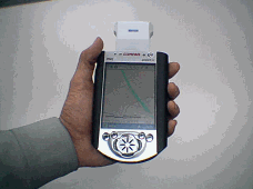
Figure 2 GPS built-in PDA
Figure 3 Digital camera
4.2 Report Support System
We developed a system for registering illegal dumping points using ArcIMS over the Internet.
We found that the report support system using the Internet reduced the time for staff to confirm the location of reported illegal dumping by about 40% of that time taken with the conventional method of reporting by telephone. Additional effects of the new system include that the system can accept reports at any time, records them as they are, and facilitates the arrangement of the fixed items of information collected from reporters.
This case study also found another effect that the system allows the administration to internally share information. The current measures against illegal dumping are performed by separate sections those are assigned for different waste types and dumping sites. Centralizing contacts results in time saving by improved internal work efficiency of the administration and in resident services improved by the integrated window.
Figure 4 System window
Figure 5 Reception of report
4.3 Effects of the Analysis Support System
We performed a case study of analyzing the characteristics of formerly reported sites at which illegal dumping was discovered frequently to work out the tendency in location of the occurrence of illegal dumping.
For this analysis, the system used ArcGIS8.1 and Spatial Analyst to create geographic data closely related to the occurrence of illegal dumping and narrow down those areas which have higher possibility of occurrence.
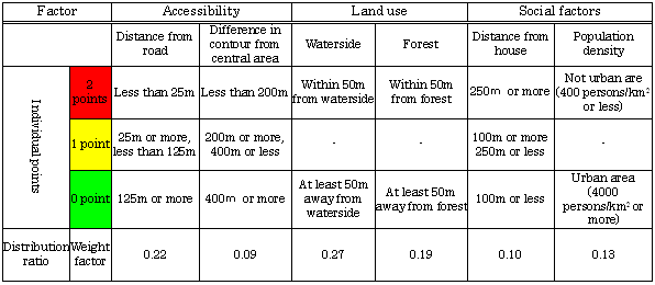
The system converts the target area into a grid of 25-millimeter squares and creates individual grid maps for six factors listed in Table 2. Each cell is given a score (0, 1, or 2) depending on the geographic condition for each factor. Table 2 lists the geographic conditions for individual factors and their respective scores.
As the six factors used for hazard maps had different weights, we calculated the weights through a questionnaire to staff. The questionnaire used a pair comparison method based on the AHP method in statistical analysis. The grid maps for six factors are overlaid to add the points for each cell together according to the weight ratio per factor. This results in the illegal dumping hazard map shown in Figure 6.
We had a hearing with staff for their impression of the hazard map and found that the tendency in range of locations seemingly apt to be subject to illegal dumping almost matched their experience. Obtaining the possibility of occurrence of illegal dumping contributes to efficient patrolling.
Table 2 Factors related to illegal dumping
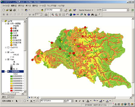
Figure 6 is an illegal dumping hazard map showing the areas with different possibilities of illegal dumping in different colors. The areas in red are where illegal dumping is apt to occur; those in green are where illegal dumping seems to be hard to occur.
Round dots on the map locate actually discovered cases of illegal dumping.
Figure 6 Illegal dumping hazard map
The case studies of the proposed systems raised the following problems to be solved:
1) As the PDA has a small data storage capacity, it is necessary to select the required map data and be capable of registering a wider range of data.
2) The carried equipment for the field investigation must be improved in waterproof and dustproof capabilities.
3) The server using ArcIMS must establish security for protecting information providers' privacy and formulate the rules for disclosing registered illegal dumping locations.
4) We should create the guidelines to more efficiently use information in the illegal dumping hazard map obtained this time.
The systems proposed this time successfully proved that the use of GISs was effective for illegal dumping reduction by the local governments. Using GIS-based IT contributes to discovering and handling illegal dumping earlier and to integrating illegal dumping information into databases leading to subsequent countermeasures. This improves services to the community suffering from illegal dumping, resulting in enhanced regional measures against illegal dumping to reduce it.
Beside the systems introduced in this paper, many GIS-based approaches have been taken to environmental issues in Japan. The "illegal dumping monitoring system using a satellite " being examined by the Ministry of the Environment is to discover illegal dumping sites earlier using satellite images. It uses a GIS to select the districts to be monitored predominantly. Another system was formerly examined, which aimed to monitor the IC card and GPS terminal mounted on each industrial waste truck to check whether it traced the authorized route for disposal.
In the fields of environmental protection, GISs can be applied not only to measures against illegal dumping but also in many other ways. A patrol system using PDAs can serve as a means of observing rare creatures and collecting their information. A system using the Internet can serve for collecting information as an environment monitoring system and for effectively providing information on natural environment management and air/water pollution monitoring as well. In addition, GIS-based systems can also be applied to the welfare fields demanding for the barrier-free environment and to the educational fields in need of the fulfillment of integrated study.
We wish to express our gratitude to staff City, Iwate Prefecture, for their cooperation to our fieldwork for evaluating the proposed GIS-based systems.
1) Actual condition survey on illegal dumping of national industrial waste (2001), Ministry of the Environment
2) GIS Action Program 2002-2005 (2002), Liaison conference between governmental bodies involved in Geographic Information System (GIS)
3) Investigation of development of the illegal dumping satellite monitoring system (2001), Ministry of the Environment
Akihiro Morita
Infrastructure GIS Department
Pasco Corporation
1-1-2
Higashiyama
Meguro-ku, Tokyo 153-0043
Japan
Telephone: +81-3-6412-2504
Fax: +81-3-6412-2573
E-mail: Akihiro_Morita@pasco.co.jp
Susumu Takagishi
Section Manager
Infrastructure GIS Department
Pasco Corporation
E-mail:
Susumu_Takagishi@pasco.co.jp