Kjersti Ruud
A new Discovery & Prospect Atlas for Statoil
From Paper to Web
Abstract
For many years, Statoil has relied on a paper based Atlas of Discoveries and Prospects.
Taking advantage of substantial developments in web based technology; a new Atlas has been implemented, allowing users to view up to date prospect resource data generated from seismic interpretation. This technology has also extensively enhanced our ability to access other corporate datasets relating to the exploration and production business.The Discovery & Prospect Atlas is an ArcIMS application displaying geographic
and tabular data extracted from Statoil’s Corporate Data Store (CDS)
and Resource Database (GeoX). This paper will address the requirements for the new Atlas, the architecture and
data flows, and the technological challenges encountered during design and
implementation.
Finally, the benefits to both the individual users,
and the greater business benefits to Statoil's worldwide operations will be
discussed.
Statoil ASA
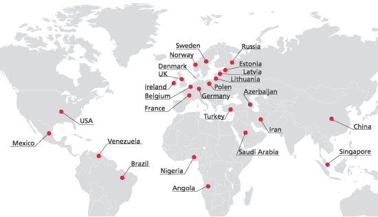
Statoil ASA is a Norwegian oil and gas company with business operations in 25 countries. As of 31 December 2001, the group had 16,686 employees.
On the basis of reserves
and production, we are an important player internationally and a leading retailer
of petrol and oil products in Scandinavia, Ireland, Poland and the Baltic
states. Every day we help to meet the energy needs of millions of people in
many countries.
Production of oil and natural gas on the Norwegian continental shelf is the
backbone of our business. But for more than a decade we have increased our
activities in other countries and aquired considerable petroleum reserves
amid stiff international competition (Statoil home page, 2002).
Statoil has the largest amount of data on the Norwegian Continental
Shelf. Almost all our seismic and drilling activities are located offshore,
and are often carried out under difficult weather conditions. We spend a lot
of money on data acquisition (mainly seismic surveys and logs). That should
give us a high motivation for taking good care of our data.
Internet Mapping in Statoil
Statoil has more than ten years experience using Esri technology. The first ArcInfo licenses were bought in 1991. There are several examples of former projects carried out in Statoil applying Esri’s internet mapping technology. The first of this kind was the “VISOK” Virksomhetsmodell Norsk Sokkel (Activity Model for the Norwegian Continental Shelf) project built on ArcView MapCafe. This project was established as a collaborating activity involving the Exploration, the R&D and the Information Technology Department. Details are described in the paper “Strategy and Implications of Utilizing Interactive WEB-based GIS as an Interface to Information in Large Organisations” (Fjell, 1999).
Also the “Halten Terrace WEB-Atlas” was a major inter- and intranet project (ArcView Map Café) This solution was in fact an electronical regional report and accompanied Satoil’s application for acreage in the 16th concession round in the Norwegian Sea (1999). It was delivered to the Norwegian Petroleum Directorate (NPD) via Secure Oil Information Link (SOIL) technology.
There is an increasing trend that E&P staff and others recognise the great opportunities and advantages of utilizing web mapping to distribute their geographical data.
Corporate Data Store
Over the last 3-4 years Statoil has put substantial resources into establishing the Corporate Data Store which contains subsurface information such as ‘Production data’, ‘Reservoir data’, Seismic data’, Well and wellbore data’ and ‘Fields and structures’ which in turn consists of several data types. In total more than 90 data types exist. The design of the data model was based on the specifications from Petrotechnical Open Software Corporation (POSC). One of the main goals of the Discovery & Prospect Atlas was to utilize the quality assured data kept in the CDS. A more thorough discussion on the issues addressing CDS and GIS can be found in the paper “Implementing the ‘Logical’ in the ‘Physical’ and making It Work” (Kvalvaag, 1999).
GeoX is Staoil’s official resource evaluation tool and data base. Resource data was initially meant to be stored within the CDS, but due to the high confidentiality issues regarding such data this implementation has not yet taken place.
CDS and GeoX are both Oracle data bases including Spatial Database Engine (SDE)
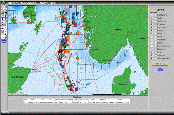
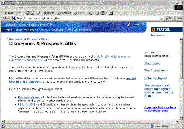
The Discovery & Prospect Atlas
Paper to WEB
The last paper edition of the Discovery & Prospect Atlas was published in 1998. The expenses of producing this book were considerable. This led to the decision not to produce it any longer. However, two years later, the constant need for easy access to this kind of information was recognised and the exploration department (NOM LET) decided to re-establish the Discovery & Prospect Atlas, this time as an interactive application.
Requirements
Apart from providing the same information as the old paper based version of the Discovery & Prospect Atlas, these were the requirements:
Map frontend
Based on corporate data (from CDS and GeoX)
Automatically updated (display current data)
Off the shelf software (no major programming)
Secure
Easy to use
Use experience from former IMS projects
Work process based on ‘prototyping’
Architecture and Data Flows
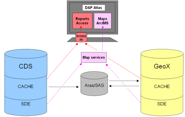
The complexity of the CDS made it very difficult to access the required data directly. This resulted in setting up a cache. Every night data is extracted from the CDS into the cache. The same was done for GeoX.
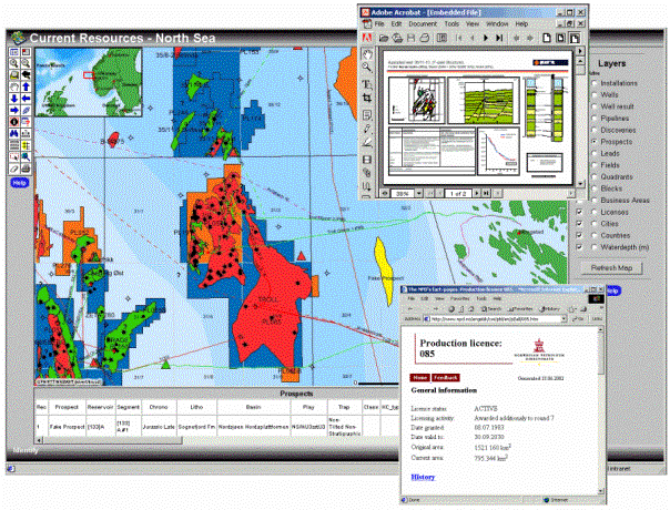
The DPA is opened from the DPA homepage. This intranet web page is set up using Domino, and is separated into two ‘sub-applications’. ArcIMS is the map interface, while Microsoft Access 2000 is the report interface. In Access, you select a license and open the desired report; ‘Work Program’, Activity History’ or ‘Resource Overview’. These reports are generated ‘on-the-fly’ by retrieving data from the cache.
No data is stored in Access, ODBC (Open Database Connectivity) is used to link tables from the CDS Cache and the GeoX Cache. Access is then acting as a client to Oracle which is the server. This paper will however not address the report interface of the DPA.
Wells
Installation
Pipelines
Discoveries
Prospects
Leads
Fields
Business Areas
Licenses
Cities
Countries
Quadrants
Blocks
The SDE-layers of the licenses and wells are generated via a ‘spatializer’ that puts together the coordinates and attributes (from the cache). Blocks, quadrants, pipelines, water depth, coastline and cities are maintained manually (by SDE versioning) and contain all the attribute-information needed within the layer.
Prospects, discoveries, and leads outlines are maintained manually directly on the SDE-layer using SDE-versioning. The attribute information from the GeoX cache, consisting of four tables, are joined to the prospect- and discovery-layers within the ‘map service’ (.axl-file).
Hotlinks are set up for four layers. Wells: links to ‘well result’ PDF files. Licenses, Business areas and Fields: links to NPD homepage.
Technical challenges
The Java Viewer was applied in the first phase of the project. This appeared to be rather unstable, and also required that the user installed the ArcIMS Viewer on his or her machine, which was not always straightforward. After testing the HTML Viewer, this seemed more stable, had the same response as the Java Viewer, required no installations for the end user, and also had a nicer user interface and better table viewer (when using the ‘identify’ tool). Therefore the HTML viewer was chosen.
Security is crucial as the resource data is highly confidential. In the first phase we managed to reflect the access on prospect and discovery layers by joining on a ‘user privilege view’ (defined in GeoX) that reflects individual access constraints. This solution became too complex to implement in the HTML Viewer. Therefore an alternative solution was implemented. This is, however, not the optimal solution.
We spent many hours trying to use SDE-views for the discoveries and prospects (where the tables had already been joined to the SDE-layer into a SDE-view). This did not work (in ArcIMS3.1)! So the solution was, as described above, to do the join within the ‘map services’.
In CDS the coordinates are stored in latitude/longitude (decimal degrees). For the Norwegian Continental Shelf the datum is ED50 with Spheroid International1909. There are three different UTM zones involved in the DPA. Zone 31, 32 and 34 respectively in the ‘North Sea’, ‘Norwegian Sea’ and the ‘Barents Sea’. Each zone needs a separate map service, as we were at the time unable to find a way of project the web sites ‘on-the-fly’. This means we need to maintain three ‘map services’ and ‘web sites’. Layers and symbolization are exactly the same for the three zones, so the ideal would be to have only one ‘web site’ which changed projection based on an ‘external parameter’.
Benefits
Availability of current data in a map interface is in itself a great benefit! Geoscientists find it extremely useful to compare and overlay different layers, and at the same time perform simple queries and click on object to obtain information about them. Distributing maps on the intranet implies that more employees become ‘enlightened’ by the power of using a Geographical Information Systems.
Visualising data using DPA also leads to improved data quality. Spotting errors on a map is much easier than in a table of numbers. Also the G&G personnel becomes aware of the importance of updating the data bases and reporting changes in the geographic objects.
Conclusion
The Discovery & Prospect Atlas is a very successful and appreciated application which allows users to easy access exploration data. It has also greatly enhanced our ability to perform strategic analysis. However we have yet not been able to distribute the Discovery & Prospect Atlas to as many users as desired due to the simple access control in ArcIMS.
Abbreviations and Definitions
ArcIMS: “Esri’s Arc Intenet Map Server”
MapCafe: “Esri’s ArcViev3.x Intenet Map Server (Map
Café)”
DPA: “Discovery & Prospect Atlas, Statoil”
GeoX: “Statoil’s official resource estimation application
and data base. Developed by Geoknowledge. http://www.Geoknowledge.com
”
SOIL: Secure Oil Information Link. http://soil.oilcamp.com
VISOK: “Activity Model for the Norwegian Continental Shelf, Statoil”
Gismap: “Statoil’s corporate tool for high-quality map
production (ArcInfo <8.0). An ArcGIS solution is about to replace Gismap”
SDE: “Spatial Database Engine (Esri)”
ACL: “XML file access control”
Spatializer: “Program that generates SDE layers with attributes”
Tomcat: “Servlet used with ArcIM. http://jakarta.apache.org/
“
Domino: “Lotus’ Web page server”
POSC: “The non-profit Petrotechnical Open Software Corporation.
http://www.posc.org ”
Statoil: “More information can be found at http://www.statoil.com “
Acknowledgements
This paper is based on contributions from the following:
Christian Ramuz Evensen, Svein Ivar Olsen, Tore Kvalvaag, Berik Davies, Egil Norbotn
References
Fjell, Knut-Olav (Statoil): "Strategy and Implications for Utilizing Interactive Web-Based GIS as an Interface to Information in Large Organizations", Esri User Conference 1999.
Kvalvaag, Tore (Statoil): “Implementing the ‘Logical’ in the ‘Physical’ and making It Work”, Esri User Conference 1999
Grimshaw, David J.: "Bringing Geographical Information Systems into Business". Longman Scientific & Technical, 1994