Veldic Vlado
ABSTRACT: This research sought to develop a practical approach for integrating the strength of GIS and Knowledge Based Systems (KBS) in supporting site suitability assessment and environmental impact prediction. It is in this respect that a prototype of Knowledge-based GIS (KBGIS), which is able to anticipate development-environment conflicts at an early stage of project planning, has been prepared. The research is an example of GIS-KBS integration in which the elements of KBS techniques are actually one of the subroutines available inside GIS. The idea of the prototype KBGIS system design was to put the model, data, domain knowledge, and the system's knowledge acquisition and reasoning mechanism together into environment of GIS.
A growing emphasis on environmental quality has prompted many counties to adopt legislation and guidelines that will ensure the consideration of the natural environment in land-use planning and site selection processes. This has resulted in considerable research and development of models that can support the location planning and decision-making processes. In most cases these models are based on the analysis of interaction between three sets of mutually related factors, namely, locations, development actions and environmental effects. This approach usually considers a comprehensive set of factors in determining vulnerability of land for various development activities and vice versa. Therefore, its effective use requires not only a flexible system capable of storing, manipulating and transforming a large volume of spatially oriented data into usable information, but also a mechanism for analysing relations and applying criteria related to environmental quality in land use planning and site selection process.
With the recent development of computer hardware and software technology, Geographic Information System (GIS) has emerged as a valuable computer-based tool in supporting a variety of spatial problem tasks. However, there is a widespread agreement that the current GIS technology does not yet provide sufficient capabilities needed to fully support complex spatial decision problems (especially those with imprecision and loose structure) (Chulmin, 1999; Fedra, 1997; Keenan, 1997). As argued by Chulmin (1999) the current GIS technology does not provide decision-making modules capable to reason about decision and are primarily based human judgments for problem solving. In other words, the user should have the decision rules in place before GIS can be utilized. To overcome these deficiencies some extensions to current GIS have been advocated, primarily through the integration with decision-making tools drawn from other disciplines (Chulmin, 1999; Openshaw, 1997; Armstrong and Densham, 1990; Goodchild, 1993).
One of the functional integration that was of particular interest in this paper is a linkage between GIS and Knowledge Based System (KBS), often referred as Knowledge Based GIS. The goal of this type of integration is to produce more useful computer tools that can assist in spatial problem solving, not only by conventional computing, but also by some sort of reasoning similar to those of human experts. Integration between GIS and KBS has been found particularly interesting in the environmental domain. Tasks in this spatial problem solving area are very often unstructured allowing heuristics and therefore knowledge based techniques to be applied.
The purpose of this paper is to illustrate how GIS could be used to support site suitability analysis for urban development. This was done by using an existing manual evaluation model developed by UNEP-UNCHS (Habitat, 1987) and converting it into a spatially enabled decision support system � a Knowledge Based GIS (KBGIS). The proposed prototype is intended to function as an intelligent - computer-based consultant in assisting screening and diagnostic processes in site suitability assessment and development-environment impact prediction. The purpose of its development was twofold, namely:
To demonstrate the usefulness of incorporating the elements of knowledge based techniques to enhance the level of intelligence of a �conventional� GIS and its ability to assist decision-makers in the process of deriving facts from existing data and conditions.
The rest of this paper is an effort to explain the strategy used to develop the prototype KBGIS. The first part
summarizes the basis of the model underlying the prototype KBGIS, while the second part explains the GIS-KBS interfacing strategy.
As mentioned in the introduction the existing UNEP/UNCHS evaluation model was chosen to develop the prototype KBGIS.
The main purpose of this model is to anticipate potential conflicts between proposed developments and the environment at an early stage of the planning
process. The model offers the possibility to identify potential problems and introduce environmental and social concerns. The early identification of these
problems and concerns allow the planners to study them and resolve the conflicts. The model has been found to be useful for regional or general
development planning activities but also for independent site suitability analysis. It has been used on several occasions as a part of environmental
planning and management routines with the main aim to make urban, regional and metropolitan development planning more responsive to environmental
considerations (UNEP/UNCHS-Habitat, 1987; Eigen,J. 1988).
From the user perspective the model can be understood as an �early-warning� procedure supported by an appropriate information system. It contains data and rules for determining compatibility between the environment and development within the area of concern. This information system is composed of the following components:
Environmental Zone Map - the composite map identifying all critical issues relating to environmental resources and hazards for each location within the study area.
Projects Impact Identification Checklists (PIIC) - grouped into two categories: (a) Impact of development (development actions classified by their potential impact on environmental sensitivity); (b) Sensitivity of development (development actions classified by their susceptibility to environmental hazards and resource shortages).
Once the above components of the model are adequately prepared and organized, the identification of potential development-environment conflicts can than be formalized and applied. Identification is done by relating the site-specific environmental resource / hazard characteristics to the proposed project, i.e. to its development implications that might affect environmental sensitivities or might be affected by environmental hazards (UNEP/UNCHS-Habitat, vol. 1, 1987). The evaluation procedure is based on:
Potential implications/sensitivities of the proposed development action (Project�s Impact Identification Checklist),
The outputs are reports containing the following information:
Potential development implications/sensitivities for the proposed project;
In this evaluation approach the emphasis is placed on the analysis of the interaction between three sets of
mutually related factors namely, location, development actions and environmental settings. It means that in the case of processing certain development proposals
it is possible to identify the most and least suitable sites for those proposals, or if the location and proposed development is known, then the
potential conflicts can be qualitatively listed. This concept incorporates a close connection between site suitability assessment and environmental impact
prediction and at the same time casts both in a larger perspective. (J. Lyle, P.
Stutz, 1986).
In the deliberation of the integration approach, it is appropriate to start the section with an overview of the basic
KBGIS functions. They can briefly be described as a set of computer assisted procedures with abilities to:
Store and offer an easily accessible repository of domain knowledge concerning various development actions (Project Impact Identification Checklist) along with a set of generic rules for assessing their potential conflicts with environmental resources/hazards (Development-Environment Interaction Matrix);
Provide automated procedures (reasoning capabilities) for identifying concerns in site-specific development-environment compatibility assessment;
Facilitate spatial data visualization, query and retrieval by the users not trained in GIS;
In order to provide an environment in which users are able to access the above functions it was necessary to combine the basic functionality of GIS with elements of knowledge based techniques. Various logical ways of linking GIS and KBS for spatial problem solving tasks have so far been identified. They range from the simplest �loosely coupled integration� that only exchange files between systems, up to a full integration of problem specific model into the GIS environment and vice versa.
The GIS-KBS linkage described in this paper is an example of the full-integration in which the elements of knowledge-based techniques are actually one of the functions available inside the GIS. The idea for the system design was to put the data, the model and the decision analysis (reasoning) process all together into a GIS environment and within one single application with shared communication routines and a common interface.
The software used for the prototype KBGIS development is ArcView desktop GIS. Data storage, query and retrieval capabilities of ArcView give the prototype KBGIS a convenient method to create a location-based inventory required for identifying the site-specific environmental constraints.
Three tools available within ArcView were employed in the prototype KBGIS system development. ArcView�s customisation
routines were used to develop the common window and icon-based menus. Dialog Designer extension was used to develop various forms and dialogues required for
interactive data and knowledge acquisition. Finally, Avenue was used to develop the system�s problem processor (inference mechanism) required for identifying,
grading and reporting concerns in the process of development-environment impact
prediction.
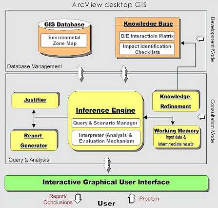
From the system design point of view, the prototype KBGIS can be thought of as a kind of Spatial Decision
Support System (SDSS) composed of four
modules (graphical user interface, database management module, analysis and query module, display and report generator). As illustrated in Figure 1 the
emphasis is on the integration of these modules within ArcView GIS.
Figure 1. Architecture of the prototype KBGIS
The graphical user interface is essentially a modified ArcView GUI designed to guide the user quickly and easily through program.
The database management module makes use of ArcView�s database management capabilities for: a) storing and manipulating the Environmental Zone composite
layer (core of the system�s spatial database) and b) creating, storing, manipulating and updating the Project Impact Identification Checklist and
Development-Environment Interaction Matrix (the system�s knowledge bases). The analysis and query module is the system�s key module. It is developed within
the �View� subsystem of ArcView, which provides tools for display, analysis, selection and retrieval of information from the system�s spatial and knowledge
databases. The role of the display and report generator is to report the evaluation results in a language familiar to the user.
As illustrated above, the prototype KBGIS has been created to function as a fully integrated GIS-KBS decision
support system aiming to replicate a specific domain of expertise. It was designed to include all of the necessary functions required for developing and
running the system.
What made this possible is the separation of the system�s database management module retaining specific knowledge on a problem domain, and its query and analysis module containing mechanism (inference engine) for applying that knowledge (see Figure 1). This feature could be interpreted as a �plug-in� architecture. It is characterized by editing functions for entering required GIS and knowledge databases that are coded separately from the system�s analysis and evaluation mechanism (inference engine).
The �plug in� architecture contributes to scalability of the system making it open and capable to reproduce a specific domain of expertise it is designed for without a need to rewrite any portion of the computer program. Consequently the prototype KBGIS can be regarded as an application specific and GIS-enabled Expert System Shell. It consists of two basic modes: (1) Development (Knowledge Acquisition) mode and (2) Consultation (Running) mode.
The KBGIS Development (Knowledge Acquisition) mode
is a collection of several tools designed to interact with the
expert in order to acquire all the components (i.e. data and domain knowledge) relevant for the evaluation. As illustrated in Figure
2, they are embedded in
an appropriate Knowledge Acquisition interface in various formats of interactive dialogues and input schemes. These input forms and dialogues tend
to emulate a �paper and pen� environment in which the user enters required information into dialogue fields shown on the screen, or selects options from
the list boxes and menus built into the system.
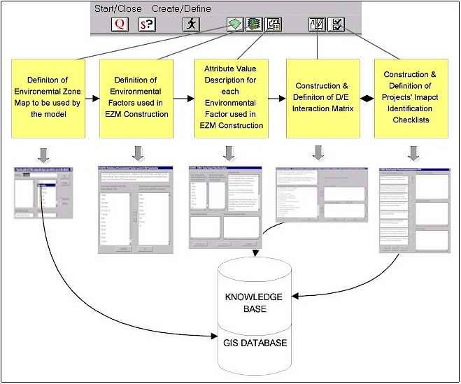
Figure 2. The KBGIS Knowledge Acquisition GUI and the steps involved in a typical
data and knowledge acquisition session supported by the system
The KBGIS Consultation (Running) mode aims at providing tools to support the identification of the site-specific development-environment concerns. It is the core of the system and consists of:
The problem-specific knowledge based reasoning system (KBS) - developed with the aid of Avenue programming language and embedded into ArcView GIS environment. It consists of the Knowledge meta-databases and the KBGIS inference engine (problem processor).
The GIS part, within this mode, is used as a slave to KBS. As indicated above, its function is to provide the means for displaying, managing, analysing and retrieving environmental data from a spatial database (�what� and �where�) and to pass them to the inference engine of the system for further analysis. The perceived role of the KBS, on the other hand, is to overcome the inferiority of GIS in analysing relations (�why�) by furnishing the system with domain knowledge as well as with the search mechanism and reasoning capabilities for identifying development-environment concerns in a language familiar to users.
From the functional point of view, the KBGIS consultation mode is nothing else but a collection of tools each serving a related set of functions that are controlled either by the user or the system itself. They are embedded into a common graphical user interface (GUI), which from the users perspective operates mostly as a window or icon-based graphic menu. The GUI provided by the consultation mode is essentially a generic ArcView GUI that is associated with its �View� subsystem and designed to provide a means for displaying, exploring, querying and analysing geographic data and their attributes. Those original tools from the GUI that are regarded as not vital for the consultation mode have been disabled and replaced by the new ones required by the system and developed with the aid of the Avenue. As illustrated in Figure 3 the new tools embedded into the generic ArcView GUI are: (1) The KBGIS query and scenario manager toolbox; (2) The KBGIS analysis and evaluation toolbox; (3) The KBGIS inference engine justifier tools; (4) The KBGIS knowledge refinement toolbox.
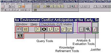
Figure 3. The KBGIS consultation mode toolbox developed with the aid
of Avenue
and embedded into the ArcView GUI
The first three toolboxes are essential parts of the proposed consultation mode. They basically represent the system�s control and reasoning (inference) mechanism, which is the brain of the whole system.
The purpose of the �query and scenario manager toolbox� is twofold, namely: (1) to interact with the user in order to get input information, and (2) to forward them to the working memory, which is hidden from the user and controlled by the system itself.
The purpose of the KBGIS �analysis and evaluation toolbox� is to provide reasoning mechanisms capable to direct (based on input data) the search through the system�s GIS and knowledge databases and to draw conclusions about the problem at hand. In essence it represents the KBGIS inference engine which is also controlled by the system for the benefit of isolating users from the �what next and how to do� type of tasks. The inference engine is composed of two components: (a) the scenario analysis, and (b) the evaluation mechanism (interpreter). The former has the purpose of interacting with the system�s working memory in order to acquire input data provided by the user and to enable the system�s scenario evaluation tools that are requested. The latter basically represents the computer algorithm that controls and carries out the reasoning process in order to generate final results for the problem at hand in a form of expert advice.
The purpose of the KBGIS �inference engine justifier tools� is to provide a variety of displays that allow the user to examine the reasoning process in order to refine it, if necessary, by means of updating or even changing the underlying assumptions.
Finally, the KBGIS �knowledge refinement toolbox� embedded into the consultation mode GUI acts as a
standalone unit separated from the system�s inference mechanism. It was primarily designed to allow the user to modify and update the knowledge bases
and to add new information (knowledge) about the domain even when using the consultation mode.
This section illustrates the basic steps of a typical consultation session as supported by the prototype KBGIS
along with the reasoning procedure that tries to reach conclusions at the end of the consultation stage.
|
The first step of a typical consultation session includes interaction with the user for the purpose of the input data acquisition. This interaction is controlled through the GUI, which provides two icon-based controls (Figure 4). They allow the user to simply point-and-click in order to invoke interactive data input procedures for the two basic types of information required by the system:
|
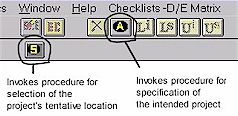 Figure 4. The KBGIS data input controls |
Specification of the intended project is accomplished through the interactive dialogue facility. It provides the user with the list of all projects (development activities) whose Impact Identification Checklists are already defined and stored within the relevant knowledge base. As soon as the project (development action) is identified, the system automatically takes over the control by passing on information to its working memory. The working memory furthermore forwards information to the inference engine, which automatically fires up the search through the relevant knowledge database in order to extract the project�s impact identification checklist and its pre-defined development sensitivities. It then enables the controls from the GUI that allow the user to re-view the project�s impact identification checklist and its development sensitivities.
The selection of the project�s tentative location is accomplished through the icon-based tool button (see Figure 4). When invoked, it firstly activates the graphic window containing the visual presentation of the study area and then prompts the user to move the cursor and pinpoint the project�s desired location. For this purposes the user is provided with various generic GIS tools (zoom, pan, etc.) in order to locate the project�s desired site as precisely as possible. As soon as the desired location of the project is identified, the system again takes over control and passes on the users inputs to the working memory. Then, on the basis of the data forwarded from the working memory, the system�s inference engine employs generic GIS search and data retrieval functions in order to acquire the environmental constraints at the proposed project site from the EZM composite layer. It then enables the control that allows the user to review the site-specific environmental constraints (see Figure 5).
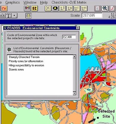
Figure 5. The screen snapshot illustrating the KBGIS ability to extract all
environmental constraints found at the selected location
Once the system has obtained all the information from the
user and the data and knowledge base it becomes �ready-to-reason� in order to
reach the conclusions and to provide the expert advice for the problem at hand.
For that purpose the user is provided with the two icon-based GUI controls that
allow him/her to simply point-and-click in order to invoke appropriate reasoning
procedure.
The following is an explanation of a typical reasoning process currently supported by the
prototype KBGIS. This applies to a situation where the system is required to evaluate and list potential conflicts with the proposed project of which the
tentative location is known. With the required user inputs (the proposed project and its location) stored into the working memory, the KBGIS inference engine
(triggered by the user through GUI control) starts the reasoning process. Firstly, it searches through the Environmental Zone composite layer in order to
extract environmental constraints (resources/hazards) found at the selected project�s location and places them into the working memory as part of the
problem description. Secondly, the inference engine also searches through the Projects
Impact Identification Checklists (PIIC) knowledge base in order to extract the list of development
implications and sensitivities attached to the proposed project. The list is then forwarded to the working memory as a part of the problem description. Once
the site-specific environmental constraints and the project�s development implications/ sensitivities are obtained from the GIS and knowledge databases and
forwarded to the working memory, the system starts the reasoning (evaluation) process and draws conclusions (e.g. to provide a list of potential conflicts
that might be expected for the proposed project at the selected location). This process involves the application of procedural (inference) rules, usually
called �pattern matching�. It basically refers to an algorithm on how to search the system�s D/E Interaction Matrix and infer conclusions on the basis of given
facts (site-specific environmental constraints and the project�s development implications) contained in the system�s working memory. An example of a
procedural rule, implemented by the proposed KBGIS inference engine is given below in its generic form:
IF development implication AND environmental constraints = TRUE (interacts)
THEN infer (return) interaction value significance ELSE continue
The inference engine provided by the prototype KBGIS uses a so-called forward chaining inference method. It operates by comparing the facts
available in the working memory to the premises of the inference rule illustrated above. In other words, all site-specific environmental constraints
found at the proposed project�s location and forwarded to the working memory are compared with each of the project�s development implications also stored in the
working memory. The comparison is done by means of searching the available D/E Interaction Matrix and inferencing the interaction values between them. If the
interaction (conflict) exists, the rule �fires� by extracting its attached significance and placing it in the working memory as a conclusion. (The
conclusion is basically an expression of the significance of the potential conflict forwarded to the working memory in a language familiar to user).
Finally, once the system has inferenced the existence and significance of all the interactions between site-specific environmental constraints and the
project�s development implications, it generates the report. This is done by extracting the intermediate inference conclusions stored in the working memory
and then ranking them on the basis of their significance. At least two lists can be generated containing different levels of significance of the inferred
conflicts that can be expected for the proposed project at the selected location. These lists are automatically shown to the user at the end of the
consultation (Figure 6).
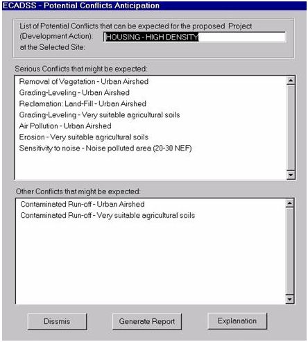
Figure 6. An example of the system's inference conclusions
provided in a language familiar to the user
Parallel to the inference conclusions described above, the system also keeps track of the whole consultation session by means of recording each and every line of the reasoning process. The results are stored in a temporary file controlled by the system and updated whenever the user restarts the consultation session. Its purpose is to allow both the user and the system builder to observe, clarify and, if necessary, enhance the assumptions underlying the reasoning process. Interaction with the user for the sake of reviewing or even printing the above-mentioned file is accomplished through the GUI control that becomes available as soon as the consultation session ends.
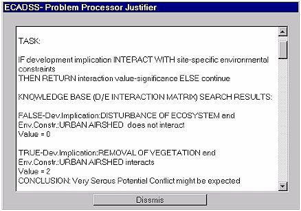
Figure 7. An example of a textual file generated by the system for the purpose
of storing assumptions underlying its reasoning process
The purpose of the paper was to present a practical example of using GIS to automate problem specific and unstructured decision making tasks and also to illustrate the approach and usefulness of incorporating the elements of knowledge based techniques to enhance the level of intelligence of current GIS systems and their ability to assist decision-makers. By applying the prototype KBGIS to a well established evaluation model (UNEP/UNCHS) the relevance and applicability could be tested and evaluated. The prototype proved that integrating different information technologies - in this case GIS and KBS - is a very useful approach to support screening and diagnostics tasks in site suitability assessment and environmental impact prediction.
Although the prototype KBGIS achieved a degree of effectiveness, it still should be
thought of as the first step towards a system with more
functions in supporting screening and diagnostic tasks in site suitability assessment and
environmental impact prediction. Much work remains to be done, especially in extending the system functionality and subsequently improving the capabilities
to assist all phases of the decision-making process.
I would like to express my sincere gratitude to Prof. Dr. Paul van Helden, Department of Geography, Geoinformatics and Meteorology, University of Pretoria for his assistance and support of this research.
Adelman, L., 1992: Evaluating Decision Support and Expert Systems. John Wiley & Sons, New York
Armstrong, M.P., and Densham, P.J., 1990: Database Organization Strategies for Spatial Decision Support Systems: International Journal of Geographical Information Systems, Vol. 4, No. 1.
Armstrong, M.P., De, S., Densham, P.J., Lolonis, P., Rushton, G. and Tewari, V.K., 1990: A knowledge-based approach for supporting locational decision-making. Environment and Planning, B 17(3).
Chulmin , J. 1999: Design of an Intelligent Geographic Information System for Multi-Criteria Site Analysis, URISA, 1999
Cowen, D.J, and G.B. Ehler, 1994: Incorporating Multiple Sources of Knowledge into Spatial Decision Support System", Proceedings of the 6th International Symposium on Spatial Data Handling, Edinburg, Vol. 2.
Eigen,J. 1988: Land Suitability and Physical Constraints to Urban Development, Master Plan for Metropolitan Lagos, Nigeria: LSG/UNCHS/UNDP/WSA.
Fedra,K. 1997: Decision Support for Natural Resource Management: Models, GIS and Expert Systems, International Institute for Applied System Analysis (IIASA), Laxenburg, Austria
Findikaki, I. 1990: SISES: An Expert System for Site Selection, in Kim, T.J., L.L.Wiggins, J.R. Wright (editors), 1990, "Expert Systems: Applications to Urban Planning", Springer-Verlag.
Goodchild, M.F.,1993: The state of GIS for environmental problem-solving, in Goodchild, M.F., B.O. Parks, and L.T. Steyaert (eds.) Environmental Modeling with GIS. Oxford University Press, New York.
Gruber,R. and Cohen,P.R. 1988" Design for Acquisition: Principle of Knowledge-system to Facilitate Knowledge Acquisition , J.H. Bosse and B.R. Gaines, Editors: Knowledge Acquisition Tools for Expert Systems, pp.131-147. London: Academic Press.
Han, S.Y., Kim, T.J., 1989: Intelligent Urban Information Systems: Review and Prospects , Journal of American Planning Association, 55(3).
Ignizio, J.P. 1991: Indroduction to Expert Systems: The development and Implementation of rule-based expert system , McGraw-Hill, Inc. New York.
Keenan. P. 1997: Using a GIS as a DSS Generator , Department of Management Information Systems, Faculty of Commerce, University College Dublin, Ireland.
Kim, T.J., L.L.Wiggins, J.R. Wright (editors), 1990: Expert Systems: Applications to Urban Planning , Springer-Verlag.
Lyle,J. And F.P. Stutz, 1986: Computerized Land Use Suitability Mapping , GIS for Resource Management: A Compendium, ACSM.
Openshaw,S., Openshaw C., 1997: Artificial Intelligence in Geography , (John Willey & Sons).
Turban, E., Aronson, J. 1998: Decision Support Systems and Intelligent Systems , 5th Edition Prentice-Hall Inc.
UNCHS (Habitat)/UNEP, 1987: Institutionalizing Environmental Planning and Management for Settlement Development" - In Environmental Guidelines for Settlement Planning, vol. 1, Nairobi, Kenya.
UNCHS (Habitat)/UNEP, 1987: Environmental Considerations in Metropolitan Planning and Management - In Environmental Guidelines for Settlement Planning, vol. 2, Nairobi, Kenya.
Veldic Vlado
Principal Planner (Research) - GIS Specialist
MLH&E
P/Bag 0042, Gaborone
Botswana
Phone: (+267) 327 535 ; 365 8607
Email: veldic@info.bw ;
vveldic@gov.bw