Kim Hodge and Neil Gilson
Abstract
This study examined the utility of using limited datasets to delineate environmentally sensitive areas in a rural municipality (M.D.) in Alberta, Canada.The subject M.D. spans an extremely diverse ecological community along the eastern slopes of the Canadian Rockies, is located adjacent to a major urban community and is subject to intense development pressures. Limited, existing, ecological data were overlaid to delineate environmentally sensitive "hotspots".Hotspots were compared to existing ecological, biodiversity and wildlife habitat data and to current patterns of development. Project outputs provide useful planning information appropriate for identifying areas of concern, scoping environmental issues, and guiding further analysis and study.
1.1 Study Area
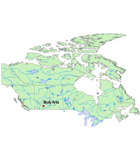
Figure 1: M.D. of Foothills
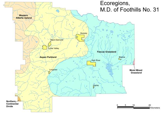
Figure 2: Ecoregions in the MD of Foothills
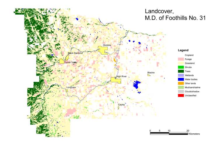
Figure 3: Landcover
in the MD of Foothills
The vegetation communities within the Ecoregions include three primary types of grassland communities, ranging from the rough fescue-sedge communities of the Western Alberta Uplands to parry oatgrass-rough fescue communities of the Foothills Fescue grassland Ecoregion. Plant species more commonly associated with the needle and thread-blue gramma grass - wheat grass communities of the Mixedgrass Prairie Ecoregion can also be found well into the central part of the M.D. on suitable sites. Forest cover in the M.D. is also diverse with lodgepole pine-white spruce dominating undisturbed sites in the western portion of the M.D. and giving way to limited aspen-balsam poplar communities in the central and eastern portions of the M.D.. Willow and birch shrublands also make up a considerable portion of the native plant cover in the western and central portions of the M.D..
2.0 Background
There has been considerable work at the provincial scale to identify environmentally-significant areas (http://www.cd.gov.ab.ca/preserving/parks/anhic/esa.asp) in the province. These areas are based on their representativeness, diversity, naturalness and ecological integrity. This work has resulted in the identification of areas at a provincial, national, and international scale within the province. Designation at this scale is of limited use for management and protection of natural resources and ecosystem processes at the scale of the M.D.. This project refines the environmentally significant areas evaluation process to identify environmentally-sensitive areas at a scale useful for planning for the M.D..
For the purposes of this study, environmentally sensitive areas (ESA's) include key physical ecosystem components and complexes that are vulnerable to the potential impacts of a broad range of land use, development and management activities, particularly, the alteration, disruption or destruction of fish and wildlife habitat, permanent or temporary soil disturbance, the removal or modification of native vegetation cover, or the release of biological or chemical contaminants. Environmentally-sensitive areas also include ecosystem or landscape elements where the impacts of land use, development or management activities as described above may directly or indirectly affect ecosystem areas or features.
Despite a number of individual studies to identify candidate environmentally-significant areas the biophysical and climatic variation found within the M.D. remains under-represented by proposed environmentally-significant models. Past work related to the designation of protected spaces or environmentally-significant areas in the M.D. has resulted in a series of proposed areas primarily concentrated along the western boundary of the M.D. These areas have also been identified for portions of the Sheep, Highwood and Bow Rivers and for a portion of Pekisko Creek. Other small areas in the central and eastern portions of the M.D. have been identified as environmentally-significant areas including Frank Lake and the Okotoks Erratic. Generally however, the grasslands and boreal forest ecoregions, and their associated wildlife and plant populations are poorly represented in past environmentally-significant areas studies. In addition, past studies have not considered environmentally-significant areas in the context of a larger connected reserve network, in terms of habitat fragmentation or patch size.
3.0 Methods
This project
identifies environmentally sensitive area within the M.D. of Foothills
based on the evaluation of limited spatial data, such as groundwater, surface
water and terrestrial ecosystem components. Natural resource and
cultural data were collected to provide the baseline information for evaluation.
Sensitive environmental features and sensitive zones surrounding those
features were identified based on professional judgment and reviews of
related literature and existing information. The relative sensitivity
of any given land location within the M.D. was evaluated by ranking each
feature and sensitive zone using a simple numerical index (Table 1).
Sensitive features were then overlaid with each other using a GIS.
The relative sensitivity of a given area was established by simply calculating
the sum of total index values of the overlapping sensitive features occupying
any given area.
Table 1: Environmental
Sensitivity Ranking Criteria
|
Variable
|
Rank
|
Description
|
|
Aquifer Vulnerability
|
1
|
Low
|
|
2
|
Medium
|
|
|
3
|
High
|
|
|
4
|
Very high
|
|
|
BSOD
|
4
|
All Locations
|
|
Landcover
|
4
|
Trees
|
|
4
|
Grassland
|
|
|
4
|
Shrubs
|
|
|
1
|
Forage
|
|
|
1
|
Cropland
|
|
|
1
|
Other Lands
|
|
|
Roadless Lands
|
1
|
0-300m from nearest road
|
|
2
|
>300-700m
|
|
|
3
|
>700-1000m
|
|
|
4
|
>1000m
|
|
|
Parks and Protected Areas
|
2
|
500m buffer
|
|
4
|
Inside Administrative boundaries
|
|
Riparian Sensitive Zones
|
30m
|
100m
|
200m
|
|
|
2
|
2
|
1
|
Provincial Code of Practice Class D
|
|
|
3
|
2
|
1
|
Provincial Code of Practice Class C
|
|
|
4
|
3
|
2
|
Provincial Code of Practice Class B
|
|
|
4
|
4
|
3
|
Provincial Code of Practice Class A
|
|
|
4
|
Lakes-Ponds-Wetlands
|
Numerically higher values
indicated more potential sensitivity
3.1 Groundwater Sensitivity Analysis
The groundwater sensitivity analysis for this project does not deal with the issues of groundwater sourcing, groundwater allocation, or aquifer depletion. While these are important and legitimate issues with respect to development plans and approvals, for the purpose of an environmentally-sensitive lands evaluation they are excluded because this type of information does not exist for the M.D. Identification of aquifers at risk of depletion is a time and money-intensive task requiring considerable fieldwork beyond the scope of this project. Groundwater withdrawal is controlled and licensed by the Government of Alberta and as such, decisions with regard to allocation are beyond the direct control of the M.D. For the purpose of identifying environmentally sensitive areas, this evaluation considers groundwater sensitivity from the perspective of potential vulnerability to contamination as a result of land development or land use activities only.
For this study, the approximate regional vulnerability to contamination (Figure 4) has been estimated using surficial geology data. Materials of coarser texture such as river-lain sands or gravels are more permeable and allow more rapid infiltration of contaminants to shallow groundwater. These areas have a relatively higher contamination risk. Conversely, thick lacustrine clays are relatively impermeable and pose a very low contamination risk to shallow groundwater. Fractured glacial tills pose a moderate to low risk.
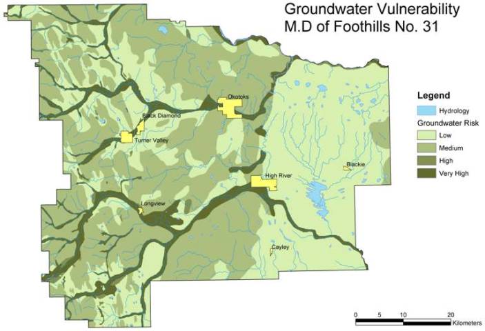
Figure 4: Groundwater
Vulnerability
These areas were ranked into one of four risk categories (Low, Medium, High or Very High) based on the assumed vertical permeability of the geological material. Each groundwater sensitivity category was also assigned an environmental sensitivity value ranging from 1(Low) to 4(Very High). This value was used to contribute to the calculation of overall environmental sensitivity in combination with other factors (see Section 3.3). Areas at Very High or High vulnerability to shallow groundwater contamination may be considered to be of considerable environmental sensitivity due to potential effects on groundwater and surface water resources.
The regional-scale vulnerability information is used most appropriately to gauge the relative vulnerability of an area. This evaluation should not be considered a definitive or quantitative evaluation of the actual risk of groundwater contamination for any given area. However, an area may be judged to be more sensitive to contamination than another area under the same development conditions. Actual risk for individual projects can only be determined by a site-specific investigation under the direction of a groundwater professional.
The vulnerability evaluation identifies groundwater contamination as an issue that should be specifically addressed within development proposals through alternative site selection and /or mitigation strategies and identifies the need for additional groundwater studies. The groundwater vulnerability evaluation also contributes to an understanding of regional environmental sensitivity when evaluated in concert with other intrinsically connected factors such as surface water resources and fish and aquatic wildlife habitat.
3.2
Surface Water Sensitivity Analysis
A variety of literature was reviewed to identify methods or procedures for mapping environmentally sensitive lands surrounding surface water features (lakes, ponds, wetlands, and streams). The review was concentrated primarily on Provincial and Federal Government Guidelines, Codes of Practice, and Standards related to petroleum, forestry, and livestock operations as well as subdivision developments. A limited review of related scientific literature was also conducted. Ecological and distance criteria for the designation of riparian buffer zones were identified as the primary result of the review.
3.3 Terrestrial Environment Sensitivity Analysis
Despite these limitations, the BSOD is useful in that it identifies potential wildlife issues within the accuracy limits and suggests potential wildlife use of similar sites in the general area of the observation. Multiple observations in the same location over time are likely a reasonable indication that the area serves as important habitat for sensitive species. Observation data was buffered using the accuracy field in the database to identify the radius within which the observation occurred.
3.3.2 Alberta Natural History Information Centre (ANHIC) Rare Plants Database
3.3.3 Environmentally Significant Areas
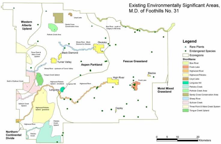
Figure 5: BSOD, Rare Plants, and Environmentally Significant Areas
3.3.4 Landcover/Vegetation
3.3.5 Parks and Protected Areas
3.3.6 Roadless Lands
Considered in isolation, roadless or undeveloped lands do not necessarily indicate environmentally sensitive lands. However when considered in combination with other factors such as vegetation cover and the presence of species at risk, roadless lands may indicate prime areas for the designation of protected areas or the implementation of environmental protection and conservation management measures. For this project roadless lands were calculated and mapped based on 1:20,000 transportation data (Figure 6)
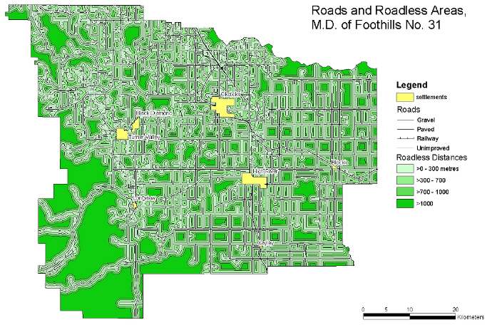
Figure 6: Roadless Areas
3.3.7 Steep Slopes
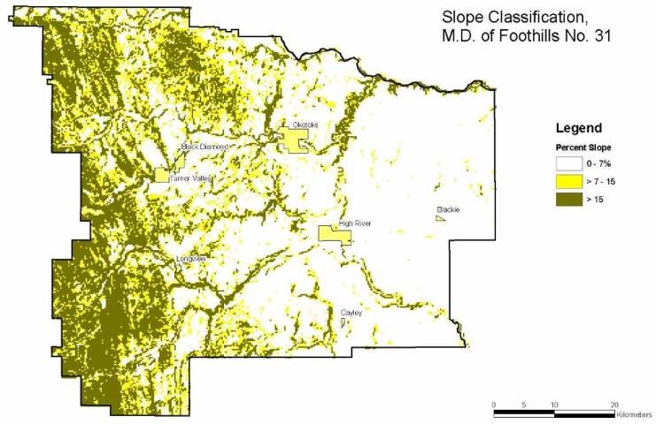
Figure 7: Slope Classification
3.4 Environmentally Sensitive Lands Analysis
The purpose of the environmentally sensitive lands analysis is to provide the Environment Committee with a way to evaluate and compare the relative environmental sensitivity of lands across the M.D.. The analysis accomplishes this task by mapping and ranking concentrations of sensitive ecological variables from the groundwater, surface water and terrestrial evaluations.
Ecological variables included the analysis are:
- Aquifer vulnerability
- RSZs ranked by fish habitat sensitivity
- BSOD data
- Landcover
- Roadless lands
- Parks and Protected Areas
The sensitivity values for each variable occupying any given cell were summed to yield a total score for each cell (ArcGIS 8.1 GRID). The possible score for any given cell ranges from 0 (sites with no data) to 24 (sites where the value for every variable = 4). The data were classified into 4 classes using the Natural Breaks default classification method in ArcView 3.2. This method identifies breakpoints between classes using a statistical formula (Jenk's optimization). The Natural Breaks method finds groupings and patterns inherent in the data. The resultant map provides a graphic representation of the location, pattern and concentration of sensitive ecological variables across the M.D. (Figure 8).
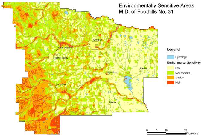
Figure 8: Environmentally
Sensitive Areas Analysis