Using GIS for Development and Processing of Surface-Water Data for the TWDB GAM Models
David L. Jordan, PE
Abstract
INTERA Incorporated is assisting the Texas Water Development Board with its Groundwater Availability Modeling project.� The focus of the GAM project is to provide a methodology to evaluate groundwater supplies over a 50-year planning horizon.� A large volume of data must be processed, analyzed, and converted to MODFLOW format for the GAM project.� In particular, information on a large number of streams must be processed into input data for the MODFLOW stream-routing package, which simulates both stream flow and stream-aquifer interaction.� We have developed a variety of automated techniques for creating the MODFLOW stream-routing package input files from ArcView GIS data.
Introduction
The focus of the TWDB GAM project is to evaluate potential groundwater management strategies for the state of Texas over a 50-year planning horizon (see http://www.twdb.state.tx.us/GAM/). The GAM models are large, complex, and regional in nature. The simulated areas are typically tens of thousands of square miles. The MODFLOW code (McDonald and Harbaugh, 1984) is being used to simulate groundwater flow. The MODFLOW code requires input of a variety of data including aquifer properties, geologic structure, recharge from rainfall, pumping, and information on surface- and groundwater interaction.
For the GAM simulations, the MODFLOW stream-routing package (Prudic, 1989) has been used to simulate stream-aquifer interaction. The stream-routing package routes surface water from streams and rivers using the Manning�s equation, and also allows each stream to gain water from, or lose water to, the underlying aquifer. The Manning�s equation is used in civil engineering to represent open-channel flow based on properties of the channel, such as slope, channel geometry, roughness of the channel, and depth (stage) of water in the channel (see, for example, Roberson and Crowe, 1985). The stream-routing package is not a true surface-water flow model but rather is an accounting program that tracks the surface flow in streams and their interaction with groundwater. The stream-routing package allows tributaries to merge and sums the flow from tributaries into the resulting confluence. Streams are represented as segments and reaches. Each reach corresponds to a single MODFLOW grid cell, and each segment consists of a group of reaches combined in a downstream order. That is, a segment represents a single stream, and the reaches represent that stream discretized onto the model grid. The stream-routing package performs routing of the surface water in the stream channel using the Manning equation, and allows gain or loss from the stream via a streambed leakance term.� The MODFLOW reservoir package was used to simulate lakes and reservoirs, but this aspect of the project will not be discussed here.
The Reach File Version 1.0 (RF1) from the U.S. Environmental Protection Agency (US EPA) was used as the source of digital stream data. The RF1 data are currently distributed as part of the US EPA BASINS surface-water modeling tools (see http://www.epa.gov/waterscience/basins/ ). The RF1 is a vector database of approximately 700,000 miles of streams and open waters in the conterminous United States. It has been used extensively by US EPA, State agencies, the US Fish and Wildlife Service and the National Weather Service. The RF1 was originally prepared by the US EPA in the early 1980s from 1:500,000 aeronautical charts from the National Oceanographic and Aeronautical Administration (NOAA). These charts included all hydrography shown on the 1:250,000 scale United States Geological Survey (USGS) maps, with extensive additions and corrections made by NOAA from aerial photography and satellite imagery. The RF1 data are attributed with a variety of stream characteristics, including stream name, width, slope, depth (stage), Manning�s roughness coefficient, and mean flow. The mean flow values were determined using a graphical regression technique by utilizing available USGS stream-gage data and extrapolating to ungaged streams (W.E. Gates and Associates, undated). The attributes included with the RF1 data set allow it to be used as the source data for the MODFLOW stream-routing package. Since the RF1 data are available in a GIS-ready format that could be utilized by ArcView (Esri, 1996a), this provided a convenient process by which GIS could be used to automate processing stream location and attribute data for development of MODFLOW input files.
One of the GAM models currently under development is the simulation of the northern portion of the Carrizo-Wilcox aquifer (Fig. 1). This is an area with a substantial number of major rivers (Fig. 2). One of the challenging aspects of developing the northern Carrizo-Wilcox was developing a methodology to convert available GIS data (the RF1 data) into MODLFOW ASCII input file format.
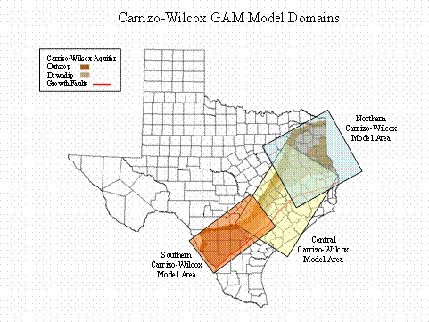
Figure 1. Carrizo-Wilcox aquifer GAM model areas
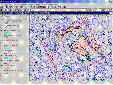
Figure 2. Streams in the northeast Carrizo-Wilcox model area.� Carrizo-Wilcox outcrop areas are shaded.
Stream Numbering
The first step in processing the RF1 data is to number the streams sequentially and in a downstream order, as required by the MODFLOW stream-routing package. In the northern Carrizo Wilcox model domain, there are approximately 900 streams, or segments (Fig. 3). This presents a substantial accounting problem when one considers the need to number each stream sequentially in a downstream fashion. Fortunately, the RF1 data have a sequential stream number associated with each stream (Fig. 4) that can be used to order the stream segments. These segment numbers cannot be directly used since the MODFLOW stream-routing package requires that the stream numbering start with 1, but the RF1 segment numbers can be used to implement a sorting and ordering routine using ArcView. The sorting routine implemented in ArcView is written in Avenue (Esri, 1996b) and accessed via a menu item that is added to the ArcView interface. The user simply selects the streams in the ArcView shapefile to be numbered, and runs the numbering routine. A segment number attribute is then added to each stream in the model domain.
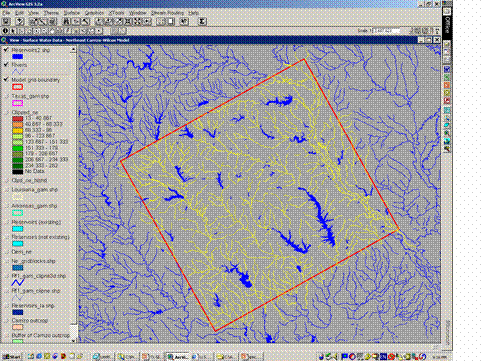
Figure 3. Streams shown in yellow will be simulated in the model.
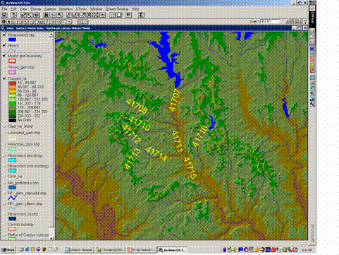
Figure 4. Sequential numbering of streams from the RF1 data.
The second step in the stream numbering routine is to identify tributaries of each stream, if they occur. The MODFLOW stream-routing package requires that tributary connectivity be identified for each stream segment (Fig. 5). The topology of the RF1 data is such that a stream can have either two, one, or no tributaries. These attributes can then be added to each stream. Tributary connectivity within the RF1 data are determined using two ArcInfo relics that are contained in the data. These two attributes are called the �from-node� and the �to-node�. When the RF1 data were originally developed in ArcInfo, the endpoints of each line were given a unique ID number: the �from-node�, and the �to-node�. Therefore, a stream which has a �to-node� that matches the �from-node� of another stream is connected to that stream (Fig. 6). Using a relatively simple sorting routine, it is then straightforward to determine, for each stream segment, the segment numbers of its tributaries (if there are any).
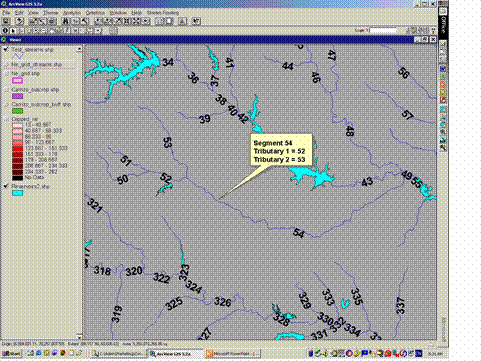
Figure 5. Example showing segment and tributary numbering.
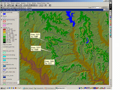
Figure 6. Illustration of topology of �from-node� and �to-node� to determine connectivity of streams.
Transferring Streams to the MODFLOW Grid
The next step in building up the data set for the MODFLOW stream-routing package is to transfer the numbered stream segments onto the model grid. This is not just a simple overlay technique whereby grid cells that intersect stream segments are selected as stream cells. The process has been optimized to filter out model cells that stream segments cross only a small portion of, so that only the minimum number of model cells necessary to represent each stream is used. Figure 7 shows the results of transferring numbered stream segments onto the model grid. The grid cells are color coded based on segment number. Next each reach, or each model grid cell along each stream segment, must be numbered in a downstream fashion (Fig. 8). This was implemented in ArcView using Avenue to subdivide each stream segment by intersecting it with the grid blocks along the segment, then sorting the midpoints of each subdivided segment along the original stream segment line. This ordering process was used to assign reach numbers to each grid cell along a particular stream segment. This process depends on the topology of the RF1 data in that all of the lines in the ArcView shapefile representing stream segments are pointing consistently in the upstream fashion. This topology allows each reach to be sorted and numbered correctly along a stream segment. Also, during the process of reach numbering, the elevation of the top of the streambed in each reach is spotted from a digital elevation model (DEM) of topography. Figure 9 shows a completed section of model grid, with the associated attributes that have been generated for each grid cell. To give an idea of scale, for the northern Carrizo-Wilcox model, there were approximately 9,000 reach cells in the model domain (Fig. 10). The automated procedure described above makes simulating large and complex stream networks much more viable than having to hand-generate the data.
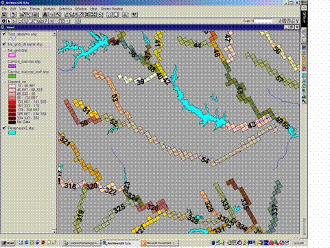
Figure 7. Stream segments shown transferred onto the MODFLOW model grid.� Grid cells are color coded by segment number.� Note that reservoirs are treated separately using the MODFLOW reservoir package.
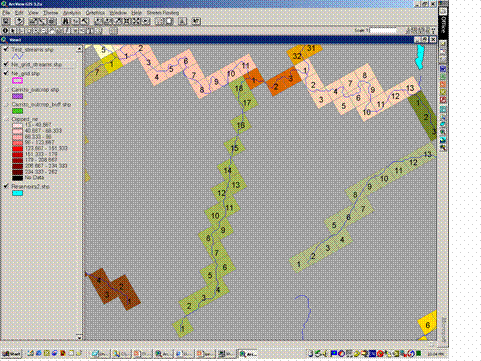
Figure 8. Reach numbering of the MODFLOW model grid.� Note that reaches are numbered in a downstream fashion.
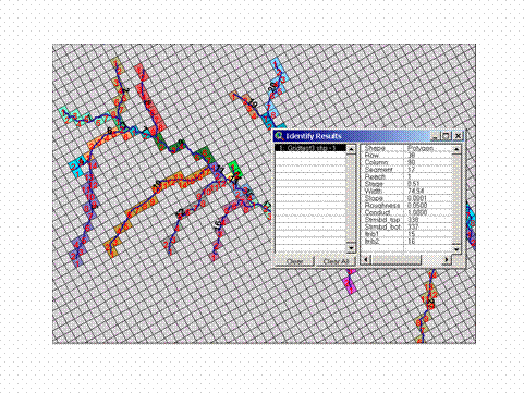
Figure 9. Illustration of attributes that have been associated with each reach (model grid cell).

Figure 10. Detail of a portion of the northeast Carrizo-Wilcox model area with stream reach cells highlighted.
Building the MODFLOW Input File Using MS Access
Once the attributes for each stream reach have been assigned to the MODFLOW grid using the automated routines in ArcView, the data are then passed to a series of automated routines, written in Visual Basic for MS Access, via Excel tables. The attribute tables from the ArcView shapefiles are simply imported into Excel, and can be subsequently read by MS Access. As shown in Figure 9, each stream reach cell is attributed with the necessary information needed to build the MODFLOW stream-routing package input file:
� Row (based on the design of the MODFLOW model grid)
� Column (based on the design of the MODFLOW model grid)
� Segment (generated during the stream numbering process)
� Reach (generated during the reach numbering process)
� Stream stage (from the RF1 data)
� Stream width (from the RF1 data)
� Streambed slope (from the RF1 data)
� Stream width (from the RF1 data)
� Manning�s roughness coefficient (from the RF1 data)
� Streambed conductance (calculated from stream width and length)
� Streambed top (taken from DEM of topography)
� Streambed bottom (calculated using the streambed top and an assumed streambed thickness)
� Tributaries of the stream segment (generated during the stream numbering process)
The MODFLOW stream-routing package requires that streamflows be specified for each starting segment. That is, each segment that is the most upstream point on any stream network (those having no tributaries), must have its flow specified. The stream-routing package then routes flows to downstream segments and calculates flows for them. For the steady-state, pre-development model of the Carrizo-Wilcox aquifer, mean streamflows from the RF1 data were used for the starting segments. For the transient model, we will develop monthly flows for each starting reach using existing USGS gage data and a regression technique to evaluate flows on ungaged streams based on flows on nearby similar streams that are gaged.
To create the final MODFLOW input file, two Excel tables are then passed to the MS Access routines. One table contains the attributes described above, and one table contains the streamflows for each starting segment. The Excel tables are then read and processed by an automated routine developed in Visual Basic for MS Access (Figure 11), which subsequently generates an ASCII text file that can be read directly by MODFLOW.
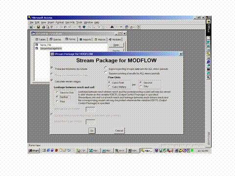
Figure 11. The MS Access interface used for processing the ArcView data and producing the MODFLOW ASCII text input files.
Conclusions
A variety of automated techniques for creating the MODFLOW stream-routing package input files from ArcView GIS data were developed. These methods allow a great deal of flexibility in adding or deleting streams from the model during model construction and calibration. Available attribute information from the US EPA RF1 data have been leveraged to provide the necessary input parameters for the stream-routing package. The utilities developed using the Avenue programming language for ArcView will automatically number stream segments and reaches, and determine connectivity between tributaries and their confluence. MS Access has then been used to generate ASCII text input files that can be read directly by MODFLOW. Using manual methods, stream segment numbering, reach numbering, and determination of tributary connectivity could be very labor-intensive. However, these operations are greatly simplified and accelerated using automated GIS and database techniques.
Acknowledgements
This work has been funded by the Texas Water Development Board (TWDB) under their Groundwater Availability Modeling (GAM) program. The author would like to extend his thanks to the staff of the TWDB for funding this project.
References
Esri, 1996a, Using ArcView GIS: The Geographic Information System for Everyone: Redlands, CA, Environmental Systems Research Institute, Inc., 340 p.
Esri, 1996b, Using Avenue: Customization and Application Development for ArcView GIS: Redlands, CA, Environmental Systems Research Institute, Inc., 240 p.
Gates, W.E., and Associates, Undated, Estimation of streamflows and the reach file: Report prepared for U.S. Environmental Protection Agency, 52 p.
McDonald, M.G., and A.W. Harbaugh, 1984, A modular three-dimensional finite-difference ground-water flow model: Report prepared by U.S. Department of the Interior, U.S. Geological Survey, National Center, Reston, VA, 528 p.
Prudic, D. E., 1989, Documentation of a computer program to simulate stream-aquifer relations using a modular, finite-difference, ground-water flow model: U.S. Geological Survey Open-File Report 88-729, 113 p.
Roberson, J.A., and C.T. Crowe, 1985, Engineering Fluid Mechanics: Boston, Houghton Mifflin Company, 712 p.
David L. Jordan, P.E.
Senior Hydrogeologist
INTERA Incorporated
One Park Square
6501 Americas Pkwy NE, Suite 820
Albuquerque, NM� 87110
(505) 246-1600 voice
�(505) 246-2600 fax
www.intera.com
djordan@intera.com