An arc of diversity, both ecological and cultural, spans the subcontinent of Africa. It stretches from coast to coast and desert to wetland, where rivers have cut deep into the continent’s substrate. Ecosystems that traverse international boundaries straddle this arc, providing glimpses of animal movement from days gone by. In addition to the wildlife that roamed the subcontinent, there were ancient cultures that made use of the alluvial deposits from the meandering rivers. Traces of these societies have given an extra dimension to a string of diversely rich habitats that, although crossed by man-made boundaries, remain undisturbed by them.
On 27 May 1990, Anton Rupert, the President of WWF South Africa (then called the Southern African Nature Foundation) had a meeting in Maputo with Mozambique’s President Joaquim Chissano to discuss the possibility of a permanent link being established between some of the protected areas in southern Mozambique and their adjacent counterparts in South Africa, Swaziland and Zimbabwe. As a result of the meeting, WWF South Africa was requested to carry out a feasibility study, which was completed and submitted to the Government of Mozambique in September 1991 (Tinley and van Riet, 1991). The report was discussed by the Mozambique Council of Ministers, who recommended that further studies were required to fully assess the political, socio-economic and ecological aspects of the feasibility study. The Government of Mozambique then requested the Global Environment Facility (GEF) of the World Bank to provide assistance for the project, which was granted. The first mission was fielded in 1991, and in June 1996 the Bank released its recommendations in a report entitled Mozambique: Transfrontier Conservation Areas Pilot and Institutional Strengthening Project (World Bank, 1996).
The report suggested an important conceptual shift away from the idea of strictly protected national parks towards greater emphasis on multiple resource use by local communities by introducing the Transfrontier Conservation Area (TFCA) concept. In short, TFCAs were defined as relatively large areas, which straddle frontiers between two or more countries and cover large-scale natural systems encompassing one or more protected areas. Very often both human and animal populations traditionally migrated across or straddled the political boundaries concerned. In essence, TFCAs extend far beyond designated protected areas, and can incorporate such innovative approaches as biosphere reserves and a wide range of community based natural resource management programs. The Peace Parks Foundation subsequently adopted this new paradigm.
As a result of the political constraints prevalent in southern Africa at the time of the initiation of the GEF funded programmes in Mozambique, only limited attention could be given to the development of formal links between the three main participating countries i.e. Mozambique, Zimbabwe and South Africa, and unfortunately this persisted throughout the duration of the study. Two years after the election of Nelson Mandela, South Africa was experiencing a rapid and significant growth in its nature-based tourism industry, but very few of the benefits associated with this growth were being made available to Mozambique. These concerns prompted Anton Rupert to request another meeting with President Chissano, and this was held on 27 May 1996. At this meeting, Rupert emphasized the significant economic benefits that Mozambique could accrue if the proposed TFCAs were implemented. The Maputo discussions were followed by a Transfrontier Park Initiative meeting in the Kruger National Park on 8 August 1996, where it was agreed in principle that the two countries, together with Zimbabwe and Swaziland, should co-operate to realize the economic benefits of the proposed TFCAs.
Towards the end of 1996, it became clear to WWF South Africa that interest in the peace park concept was not only growing within the country but also in the neighbouring states. For the first time, southern Africa was being recognised as a tourism destination, not just South Africa or other countries on their own, and an integral part of this vision was the development of TFCAs or peace parks involving all of countries in the Southern African Development Community (de Villiers, 1994; Pinnock, 1996). There was a growing recognition that tourism is the one industry that has the potential to aid the economic engine in creating jobs that are so urgently needed in the sub-continent.
The Peace Parks Foundation has been constituted and established in South Africa as an Association incorporated under Section 21 i.e. a company “not for gain”. It has virtually all the powers of a normal company, but cannot have shareholders, and no profits can be paid to supporting members. The Foundation is managed by a Board of Directors under the Chairmanship of Anton Rupert, and has eight Honorary Patrons namely President Mbeki (South Africa), President Mogae (Botswana) His Majesty King Letsie III (Lesotho), President Muluzi (Malawi), President Chissano (Mozambique), President Nujoma (Namibia), His Majesty King Mswati III (Swaziland), and President Mugabe (Zimbabwe). President Mandela (South Africa) is Patron Emeritus. The overall objective of the Foundation is to facilitate the establishment of Transfrontier Conservation Areas focusing on the Southern Africa Development Community (SADC) supporting sustainable economic development, the conservation of biodiversity; and regional peace and stability. TFCAs involve a unique level of international cooperation between the participating countries, particularly on sensitive issues related to the opening of international boundaries within each region, thus support from the top political level is required. The Peace Parks Foundation has received endorsement from the highest political levels in order to further the first phase of this programme, which involves Botswana, Lesotho, Malawi, Mozambique, Namibia, South Africa, Swaziland, Tanzania and Zimbabwe.
Specific objectives include the following:
1. Facilitate the establishment of TFCA by appointing full time coordinators to drive the processes required.
2. Raise and allocate funds to projects (essentially of a capital nature) which will further the establishment and management of TFCAs. These projects will have been approved and recommended to the Foundation by the relevant conservation agencies responsible for managing the TFCAs.
3. Negotiate loans to the TFCA conservation agencies for approved projects.
4. Negotiate with governments and semi-government bodies with regards to political and land tenure/legal issues associated with TFCAs.
5. Promote the development of TFCAs on a commercial basis (including private sector development) as and when appropriate within the parameters imposed by environmental and conservation practices and principles, and to involve local communities.
6. Promote the case for TFCAs nationally and internationally in terms of their economic viability, ecological sustainability and their contribution to the conservation of global biodiversity. Every effort will be made to promote the recognition of TFCAs as World Heritage sites if applicable. Special attention will be given to promoting broad-based education programmes for residents in or adjacent to the TFCAs.
For TFCAs to become a reality, support is required at five levels, namely:
1. Political. TFCAs involve a unique level of international cooperation between the participating countries, particularly on sensitive issues related to the opening of international boundaries. An open commitment by each Head of State is an essential prerequisite for the TFCA to succeed.
2. Regional. Within each region, the relevant international bodies have a key role to play in facilitating the process. SADC’s support for the TFCA process is of paramount importance.
3. Technical. Within each TFCA all the relevant “technical” responsible agencies must be consulted and involved, including the conservation departments and government departments responsible for immigration, police, home affairs, customs, health, etc.
4. Local communities. All local communities in and adjacent to the TFCAs must be consulted at the start of the development process and every effort should be made to make them partners in the business opportunities that will open up.
5. Financial. TFCAs are expensive to establish and run successfully. Financial support must be forthcoming from the State, with perhaps the bulk of the funding coming from private sector investments and bilateral and multilateral aid agencies.
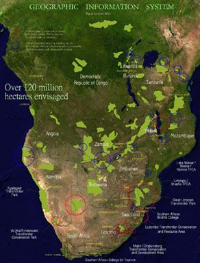
The dream to create Transfrontier Conservation Areas (TFCAs) in southern Africa is fast becoming a reality. Countries across the region are joining hands to share in the benefits of transfrontier conservation. In many instances the process is now moving to the next level, namely planning the implementation of TFCAs and the actual development of the areas selected. For all of this, detailed information is required.
Aware of this need for information, the Peace Parks Foundation has brought to the table a new component to assist in the facilitation and planning of TFCAs. A Geographical Information System (GIS) was established at the Foundation to support the development of each of the TFCAs.
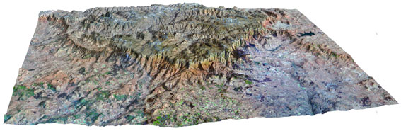
Satellite imagery is used to visualize the surface of the land and to derive information. This technology and information can also be used to monitor animal movements and the ecological patterns of the proposed TFCAs.
To ensure that this new service is effective, the Foundation has set up a GIS laboratory and appointed various specialist staff members. Information is the basis for any decision and now TFCA facilitators and planners will have detailed information at their disposal to make the correct decisions to bring these TFCAs to fruition. This support will enable conservation authorities involved in the various TFCAs to jointly plan and develop the establishment of each one.
The procedures employed by the PPF GIS are the following:
1. Awareness
As most of these regions lie “hidden” in the corners of the countries and some being relatively inaccessible or off the beaten track, it is important to visually locate not only the whereabouts of individual Parks, but to look at the placement of each park in relation to surrounding protected areas.
2. Initial Planning
Data from the various regions are analyzed and an initial management and tourism zonation plan is derived. The relevant involved parties then use this initial plan for decision-making purposes. Information layers are updated and kept in the information loop.
3. Contribution to Park Management
Transfrontier Conservation Management: the derived information is made available to the relevant involved parties of each TFCA. Spatial Information has been used for, amongst others, the following:
Wildlife translocation; Determining fence line placement and removal; Lodge site identification; Wildlife tracking; Determining surface areas; Identifying prioritized land for additional expansion; Identifying community location and ensuring their involvement.
4. Customized Software
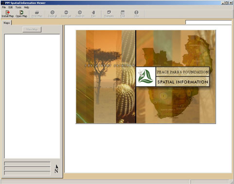
The importance of disseminating information into the field is an important factor, and although hard copy maps are an important medium, the PPF GIS identified the need to disseminate both spatial and attribute information into the field. For this the PPF GIS have developed two software packages. One being the ‘PPF Spatial Data Viewer’ and the other being the ‘new world GIS Viewer’.
PPF Spatial Data Viewer
This Software developed in Visual Basic with MapObjects Lt allows for the basic functionality of any viewer such as pan, zoom and query, but in addition it allows for a spatially linked reporting on all attribute information of the TFCA project. This has given the role players information at their fingertips.
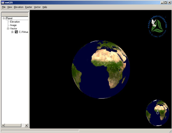
new world GIS Viewer
This application has been developed with C++ and makes use of primarily Digital Elevation Models (DEM) and satellite imagery to allow for real-time virtual fly through of a landscape. Further development is in progress to overlay shape files and to render different textures.The development of this software is to ensure that there is an understanding of the landscapes in which these TFCAs are located, additionally and as importantly, many rural people have understood more clearly the TFCA concept when viewing the various parameters in 3D.
The Peace Parks Foundation focuses on four legs to ensure that the drive towards Transfrontier Conservation is sustainable, these are:
Management of space; Management of training; Accommodation; Accessibility
GIS support is offered to each component to ensure that spatial information and knowledge is available to each.
The management of spaces is as discussed, and is relevant to the Transfrontier Conservation of Protected Areas.
For the management training aspect, the Southern African Wildlife College has been established to facilitate the training of managers for wildlife areas. The PPF GIS contribute an ‘Introductory to GIS’ course for 10 days to each group of diploma students. This is offered together with GIMS (Esri’s Southern Africa’s distributor), who start the course with an “Introduction to ArcView GIS” course. The course briefly introduces spatial concepts and the fundamentals for GIS for wildlife management.
The support offered to accommodation and accessibility has not yet been fully implemented, but the PPF GIS are looking to formalize partnerships with other organizations that are working in those sectors.
The PPF GIS is now eighteen months into its program, and although the groundwork has been setup and put in place, many challenges and limitations are encountered. GIS has offered significant support to the Transfrontier Conservation and has put it on the map.
Although the functionality of the PPF Spatial Data Viewer in getting information into the field in a user friendly and effective manner is substantial, we would like to move further toward the Internet as our preferred means of disseminating information. As most of the sub-continent of Africa still does not have satisfactory Internet access, Internet mapping has not been implemented. The work, which is being done, is planned and structured in order to allow for future deployment on the Internet.
The results we hope to achieve with the training offered at the SAWC is firstly to introduce GIS/GPS to the people who will be directly involved with management in Wildlife Areas, and secondly to offer a standard and foundation for GIS work to take place. From our experience we have determined the lack of a standards driven and a standards based means of GIS work in Southern Africa.
Esri CP; PPF Executive Director Prof. Willem van Riet; PPF Board of Directors; Pierrette Schlettwein; GIMS (Patrick McKivergen, Ingrid Landman).
As the awareness for Transfrontier Conservation moves further north into the remainder of Africa, we would like to see the use of GIS grow and continue to offer the necessary information for the sustainability of biodiversity and socio-economic growth for the African continent. This will allow the accessibility of GIS and spatial information to proliferate and resultantly introduce new and innovative methods of going about spatial information work in Africa. The current segmentation, which seems to be prevalent in the GIS sector in gathering and deriving information, will then seek to reduce work duplication, wastage of resources and seeking common goals.
We hope the role that the PPF play in the identification and facilitation of TFCAs in southern Africa (and worldwide) will allow for the PPF GIS to embark on a similar program to bring together fragmented data and facilitating its use and function. By offering the future managers of these wildlife areas an introduction to the technological benefits and processes of GIS and other related technologies, a contribution will be made to bring about a more effective approach to conservation GIS in southern and all of Africa.
Hamilton et al, 1996; Westing, 1993
Tinley and van Riet, 1991
World Bank, 1996
De Villiers, 1994; Pinnock, 1996
P.O. Box 12743, Die Boord, Stellenbosch, Western Cape South Africa, 7613
Tel: +27(0) 21 887 6188 Fax: +27(0) 21 887 6189 cbeech@ppf.org.za