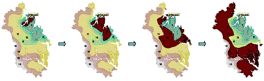
(a) April 7 a.m. (b) April 7 p.m. (c) April 8-10 (d) April 10-12
Figure 2. Forest fire spreading over times in Samcheok city
Seung-Ho LEE, Cheol-Min KIM, Dai-Kyun RHO
ABSTRACT
The tremendous huge forest fire broke out along the East Coast in Gangwon Province, Korea and lasted over a week in April 2000. More than 16,000 hectares of forest area was assumed to be burnt and damaged by forest fire. In order to detect and assess the forest ecosystem changes of forest burnt area over times, multi-temporal Landsat TM data obtained in May 20, 1998(before fire occurrence), May 25, 2000(a month later after fire extinction) and May 28, 2001(a year later after fire) were used, respectively.
After image to image registrations, NDVI values were derived from time series image data set and Image Differencing algorithm was applied to detect changes. The NDVI value of burnt forest was revealed to be 151.2 in 2000 image and this value was extremely lower than 191.8 of 1998 image. But the NDVI(178.8) of 2001 image, just one year later was higher than that of image 2000. This result indicates that the vegetation cover of burnt forest area was getting recovered after forest fire.
Key words : Forest Fire, Multi-temporal Landsat TM, Change Detection, NDVI, Image Differencing
Nowadays the global environments are becoming the hot issues to human beings in the world. Environmental pollution and vast deforestation due to the industrialization and urbanization, natural disasters such as flooding, drought, and especially forest fire caused by global warming are in common. Since UNCED conference in 1992, forest is one of the most important global concerns in addition to environment. Forest absorbs and sinks the carbon dioxide from the air, and has a role to dilute the global warming influenced by green house effect.
Forest fire is very important and sensitive in Korea as one of major disturbances resulting in changes of forest ecosystem function. The climate and topography in mountainous region provide more chances for ignition. In fact, dry periods from late of autumn to spring that result in dry fuel, vegetation that is vulnerable to ignition, and wind drive flames. By effectively suppressing fire in the past 30 years, humans have influenced the fire-dependent forests in Korea. As a result, species composition and stand structures have changed, leaving the forests more prone to higher intensity of fires.
Once forest fire occurred, it spread out very rapidly as to bring about the tremendous damages. It is too difficult to access the fire place and to control the fire occurred in rugged and remote mountains. Moreover it is not easy for the surveyor to investigate the damage status after fire suppression.
Meanwhile, satellite can repeatedly observe the wide area at once and continuously acquire the information about the ground features and environmental changes. Satellite sensors can detect the electro-magnetic radiation energy reflected from the earth over a wide range of spectrum with a visible and infrared wavelength, and record it in digital image. Moreover, as most of satellite images are analyzed through computer systems, it has many advantages to acquire the various information simultaneously rather than visual interpretation. So to speak, it can effectively detect the inner phenomena which are not recognizable with eyes as well as the outer ones.
Likewise the spectral reflectivity of the ground features detected by satellite sensor can show the characteristics of phenomena about damaged forest current and after fire. Thus, it is more useful to use satellite images to investigate the ecological damage affected by forest fire and to monitor the recovering process. However, considering the mortality of vegetation and leaves, it is more appropriate to use the image acquired in several weeks later rather than few days after forest fire(Jakubaukas etc., 1990).
Therefore, the objective of this study was to detect and evaluate the forest damage and recovering process over times after forest fire occurred in Samcheok city, using multi-temporal Landsat TM image data obtained in 1989, 2000 and 2001. In order to monitor the vegetation changes over times, NDVI values were derived from time series image data and Image Differencing algorithm was adopted for change detection. In the next stage, with the integration of GIS techniques we are going to find out the relations with vegetation recovery involving the site conditions and topographic factors.
Multi-temporal Thematic Mapper image data obtained from Landsat-5 launched by NASA, USA were used. Landsat TM image has 7 bands with 3 visible and 4 infrared channels including one thermal band. The spatial resolution of one pixel of TM image is 30m by 30m except thermal band with 120m by 120m.
| Image Data | Date of receiving | Remark |
|
Landsat TM |
May 20, 1998 | two years before forest fire |
| May 25, 2000 | one month later after forest fire | |
| May 28, 2001 | one year later after forest fire |
(a) April 7 a.m. (b) April 7 p.m.
(c) April 8-10 (d) April 10-12
Figure 2. Forest fire spreading over times in Samcheok city
Raw satellite images usually contain geometric distortions so significant. Image distortions come from the change of satellite orbit and variations in the altitude and velocity of the sensor platform, and eastward rotation of the earth beneath the satellite during imaging and so on.
Geometric correction is implemented to adjust the unknown random distortions to a real world map coordinate system. Number of ground control points(GCPs) were selected from the topographic maps for geometric correction and transformed to a Transverse Mercator coordinate system adopted in Korea.
Some major parameters used for map projection are as follows :
- Spheroid and datum : Bessel, Tokyo
- Origin of projection : E 129ˇŁ in longitude, N 38ˇŁ in latitude
- False Easting at central meridian : 200,000m
- False Northing at origin : 500,000m
In order to obtain the precise X,Y coordinates for each GCP point, topographic maps at the scale of 1:25,000 were scanned by Contex color scanner and converted to the digital image maps which has the same coordinates with digital topographic maps produced from National Geographic Institute, Korea.
For rectification second order polynomial transformation equations were derived and bilinear interpolation resampling method was used to determine the pixel values of new rectified image with a size of 30m by 30m.
Image registration is the process of making an image conform to another image and involves georeferencing if the reference image is already rectified to a particular map projection. Thus image to image registration is usually used for time series data like multi-temporal images over the same region in order to place the same coordinate system to disparate images.
Therefore, 1998 image data was rectified to a Transverse Mercator projection and the other two images acquired in 2000 and 2001 respectively, were co-registered with image to image registration method. The total root mean square error(RMSE) of the registered images was 0.25 pixel, which was quite low to accept the RMSE limit required for the change detection. In general, RMSE limit for the change detection is preferred less than 0.5 pixel when registering the images.
Vegetation Index is often used to explain the vegetation phenomena in the image data as a means to interpret the differences among various vegetation types, and between vegetation and artificial objects. As every object shows different reflectance values and reflectivity patterns according to varying wavelength, vegetation index can be computed with a algebra function compromising these characteristics.
For example, spectral reflectance curves for healthy green vegetation almost manifest the "peak-and-valley" configuration. In the visible portion of the spectrum chlorophyll strongly absorbs energy in the wavelength bands centered at about 0.45(blue) and 0.67§(red), while the high reflection of green energy. In the near infrared portion of the spectrum at about 0.7 to 1.3§, healthy vegetation shows a very high reflectance values at about 40 to 50 percent of the energy incident upon it. On the other hand healthy plants shows relatively low reflectivity in red band.
Likewise, many plant stress alter the reflectance in both visible and near infrared wavelengths, and sensors operating in this range are often used for vegetation stress detection such as damaged forest by fire, insect and disease attack.
Therefore, based on this reflectance pattern of vegetation, various models of vegetation indices are developed to explain the healthiness, vigor, vegetation cover, and biomass of the plants. Various mathematical combinations of the Landsat channel 3(Red band) and channel 4(NIR band) data have been found to be sensitive indicators of the presence and condition of green vegetation. These mathematical quantities are thus referred to as "vegetation indices". The normalized difference vegetation index(NDVI) is preferred to the simple index for vegetation monitoring because of the compensation for changing illumination conditions, surface slope, aspect, and other extraneous factors.
The typical NDVI is computed from the equation below. Vegetated areas will generally yield high values for VI index because of their relatively high reflectance in NIR and low in visible wavelength. On the contrary, water and bare soil areas have higher reflectance in visible than NIR, thus these features yield negative(-) and near zero(0) indices.
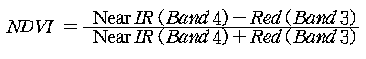
As mentioned above, NDVI values varies from (-)1 to (+)1 according to vegetation conditions. Likewise, as NDVI image has a very low contrast, radiometric enhancement such as contrast stretching was introduced to the NDVI image. Finally the transformed NDVI image having the 8bit data from 0 to 255 was produced using the formula below.
In order to detect and to assess the forest ecosystem changes of forest burnt area over times, multi-temporal Landsat TM data obtained at a year before forest fire, a month later after fire extinction and a year later after forest fire were used, respectively.
Change detection involves the use of multi-temporal image data sets to
discriminate the changes between dates of imaging.
There are two ways to detect the changes in case of using satellite image data
; 1) post-classification comparison and 2) pre-classification
interpretation. In latter one numerous change detection methods such as
composite analysis, image differencing, principal components
analysis(PCA), and change vector analysis are employed in common.
But every method has its own advantage and disadvantage, thus the choice of
most appropriate one depends on the objectives of change detection,
expectation level of probability and status of the image acquired and so on.
In the image differencing procedure for change detection, the corresponding pixel values(DNs) from one date(t1) are simply subtracted from those of the other(t2) as shown in the equation below.
DXkij = Xkij
(t2) - Xkij (t1)
where, Xk : pixel value(DNs) of band k,
The difference in areas of no-change will be very small approaching zero(0), on the other hand areas of change will manifest larger negative(-) or positive(+) values. When image differencing is employed, the analyst must find meaningful "change/no- change threshold" within the data. This can be done by compiling a histogram of normal distribution with a mean value at zero for the differenced image data, and noting that the change areas will reside within the tails of the normal distribution. This method is widely used for as one of the change detection algorithms for various kinds of environmental assessment in relation to topographic factors.
Figure 3 shows the data sets of Landsat TM images covering the study area located in Samchuk city, Gangwon Province. Image (A) was obtained in May 20, 1998(before fire occurrence), image (B) was acquired in May 25, 2000(a month later after fire extinction) and image (C) was acquired in May 28, 2001(a year later after fire extinction), respectively. Most of the individual triplicate data sets were acquired in the same season to avoid the variation of seasonal plant phenology and its radiometric characteristics. False color composite with a combination of band 4(NIR), 3(Red), 2(Green) was made to discriminate the vegetation conditions clearly, and in Figure 3 vegetation covers with high vigor will appear bright reddish color in this image. On the other hand, burnt forest and non-vegetation area look as cyan and yellowish green in false color composite image.
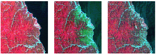
(A) May 20, 1998 (B) May 25, 2000
(C) May 28, 2001
Figure 3. Satellite image data used for change detection
When evaluating and monitoring the change conditions of burnt forest by using image differencing method, the difference of the pixel value in every pair of 7 bands of image data set can be calculated theoretically. In case of necessity, it is more efficient to compare the differences between new component bands obtained from NDVI and PCA. To do this, we investigated the 6 bands except thermal Band 6 and NDVI for each image data. Referring to the previous researches, NDVI was one of the most effective ways to detect the burnt forest using bi-temporal satellite image, and when classifying the burnt forest using multi-temporal satellite image, Kauth-Thomas Tasseled Cap analysis gave better result in classification accuracy rather than PCA(Green etc., 1994 ; Patterson and Stephan, 1998).
The differences were computed for each corresponding band and NDVI from two dates of imaging; May 25, 2000(a month later after fire) and May 20, 1998(before fire), and the resultant image were shown in Figure 4. Thus to some extent the burnt forest area would be detected through the comparison of differences in this new image data.
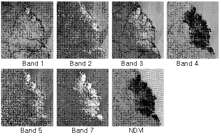
Figure 4. Image differencing between two dates of imaging, before
(May 20, 1998) and a month later(May 25, 2000) after fire
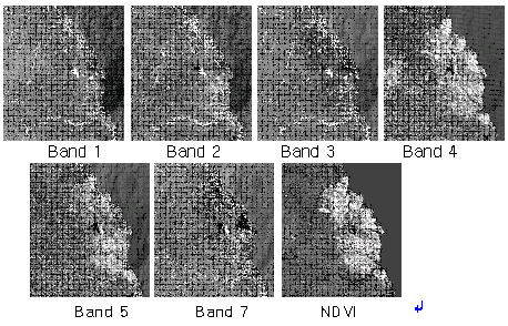
Figure 5. Image differencing between two dates of imaging, a month later
(May 25, 2000) and a year later(May 28, 2001) after fire
In the same way, Figure 5 shows the result acquired from image differencing of two dates between current year of fire occurrence and a year later after fire. The differences of changes were distinctively appeared in both Band 4 and NDVI.
Based on NDVI values, the forest conditions of two dates between before and after fire were analyzed for damaged forest area where the joint inventory unit delineated the boundary of burnt forest. The area extent of total burnt forest area was revealed to be approximately 16,118.5 hectares.
Table 2. NDVI change of burnt forest area over times
| Categories | Date of Imaging | NDVI Statistics | ||||
| Mean | S.D. | Minimum | Maximum | |||
| Before Fire | 1998. 5. 20 | 191.8 | 14.0 | 82.6 | 217.5 | |
| After Fire | Current | 2000. 5. 25 | 151.2 | 23.6 | 97.7 | 213.7 |
| One year later | 2001. 5. 28 | 178.8 | 20.5 | 61.2 | 227.4 | |
Table 2 shows the some statistics of NDVI values over times. The mean NDVI value of burnt area was revealed to be 151.2 in the image of May 2000, just a month later after fire extinction, and this value was much lower than 191.8 of May 1998, before fire. While, the NDVI(178.8) of May 2001, just one year later was slightly higher than that of image 2000. This result means that the vegetation cover of burnt forest area was getting recovered after forest fire. But due to the cloud and cloud shadow effects for some places, the NDVI value of 2001 image had extremes in minimum and maximum statistics. Because, cloud area showed very high NDVI values and on the contrary shadow part of cloud had very low values.
Considering the NDVI change of corresponding pixels in bi-temporal images, the restoration of damaged forest was evaluated over times between the current year of forest fire and one year later after fire extinction.
Forest burnt area were classified into 4 categories such as "increase", "moderate increase", "no-change", and "decrease" of NDVI change. The most appropriate threshold value among the candidates is determined by evaluating the standard deviation(SD) of NDVI values. For classification of burnt forest according to NDVI value it is very important how to determine the threshold level(Fung and Ledrew, 1988). The threshold value of 0.9ˇżSD gave desirable result for detecting the burnt forest, and the overall accuracy of classification was 93.8% and Kappa coefficient was 0.82, respectively. Finally the change level of NDVI values were shown on Table 3. Here on Table 3 the increase of NDVI means the fact that the condition of vegetation was getting better and better since the fire was controlled and also it plays a indicator to reveal the forest recovery.
As a result, 46.4% of burnt forest with a size of 16,118 hectares was appeared to the area of NDVI "increase". But comparing the increase rate of 3.1% for undamaged forest, it was assumed to indicate the vegetation recovery without doubt. Nevertheless, any further research and investigation for the area of both "no-change" and "slightly change" may need to how to differentiate them from the area of NDVI "increase". Moreover, some factors such as topographic features and intensities of forest fire also seem to influence the result a little. The NDVI decrease for burnt forest was the area affected by clouds.
Table 3. NDVI change between current year and one year late after fire (unit: ha)
| ˇˇ | Total |
Increase (High) |
Increase (Moderate) |
No Change | Decrease |
| Damaged Forest | 16,118.5 (100%) |
7,483.2 (46.4%) |
5,726.0 (35.5) |
2,376.2 (14.7) |
533.1 (3.3) |
| Non-Forest | 13,080.6 (100%) |
406.5 (3.1) |
2,673.6 (20.4) |
8,186.2 (62.6) |
1,814.3 (13.9) |
Multi-temporal Landsat TM data were used to monitor the forest ecosystem changes of burnt forest area where the strong forest fire broke out in April 2000.
After image to image registrations, NDVI values were derived for each image and Image Differencing algorithm was applied to change detection.
The NDVI value of burnt area was revealed to be 151.2 in 2000 image and this value was extremely lower than 191.8 of 1998 image. But the NDVI(178.8) of 2001 image, just one year later was higher than that of image 2000. This result shows that the vegetation cover of burnt forest area was getting recovered after forest fire.
Forest burnt area were classified into 4 categories likewise "increase", "moderate increase", "no-change", and "decrease" of NDVI change. As a result the 46.4% of burnt forest was appeared to the area of NDVI "increase", it was assumed to indicate the forest recovery to some degree.
Fung, T. and E. Ledrew. 1988. The determination of optimal threshold levels
for change detection using various accuracy indices. Photogrammetric
Engineering & Remote Sensing 54(10) : 1449-1454.
Green, K., D. Kempka and L. Lackey. 1994. Using remote sensing to detect and
monitor land-cover and land-use change. P.E. & R.S. 60(3) : 331-337.
Jakubaukas, M.E., K.P. Lulla and P.W. Mausef. 1990. Assessment of Vegetation
Change in a Fire Altered Forest Landscape. P.E. & R.S. 56(3) : 371-377.
Koutsiast, N. and M. Karteris. 1998. Logistic regression modeling of
multi-temporal Thematic mapper data for burned area Mapping. Int. J. of remote
Sensing 19(18) : 3499-3514.
Koutsiast, N. and M. Karteris. 2000. Burned area mapping using logistic
regression modeling of a single post-fire Landsat-5 Thematic Mapper image.
Int. J. of remote Sensing 21(4) : 673-687.
Patterson, M.W. and Stephan R. Yool. 1998. Mapping Fire-Induced Vegetation
Mortality Using Landsat Thematic Mapper Data: A Comparison of Linear
Transformation Techniques. Remote Sensing of Environment 65 : 132-142.
Won, Kangyung and Jungho Im. 2001. Fire Severity Mapping Using a Single
Post-Fire Landsat-7 ETM+ Imagery. J. of the Korean Society of
Remote Sensing 17(1) : 85-97.