 Temporal variations were also significant,
seasons being characterised by different emissions (patterns of travel and
heating of buildings changing), photochemical activity, wind and rain. ��
Temporal variations were also significant,
seasons being characterised by different emissions (patterns of travel and
heating of buildings changing), photochemical activity, wind and rain. ��M.J. Mineter, A.N. Skouloudis
Sustainability indicators aid in the understanding, monitoring and management of the environment. We discuss the methods used within our work for the processing of geographical data in order to derive spatially discretised indicators, held in nested rasters, the most coarse representing Europe using cells of 0.3 degrees.� The paper describes the early stages of processing using ArcObjects and ArcMap to extract areas, lengths and values expressing the contributions of polygon, line and point data (respectively) from a variety of input datasets to each raster cell, achieved by an intersection operation.
For some years sustainability indicators have been used to simplify the representation of the complexities of the environment, in an attempt to facilitate the creation and validation of environmental policy.� They are generated in describing the current state of a system, the pressures upon the system, and the responses that are or could be made in seeking sustainability. �Indicators are used in addressing problems such as desertification, pollution ��and agriculture.� The Cities Environment Reports on the Internet (CEROI) programme utilises indicators seeking �to support sound decision-making and general awareness-raising in cities�. �Each different indicator is a representation of one or of many environmental, geographical, or socio-economic factors.
It is widely recognised that great caution must be exercised in the use of these indicators. In general the simpler is the presentation of complicated data, the more complete and precise must be its communication � a lesson well-known to GIS professionals who are alert to their� power to inadequately but attractively present poor data so derailing informed discussion.� Indicators do have potential for illuminating complexities, as Jochen Jesinghaus explores for many countries (Dashboard).�
Financial indexes can be considered as an analogy for indicators. In the financial markets the NASDAQ index or FTSE index represents an overall trend in prices of a set of companies� shares.� A sufficient number of companies are involved in each index that one does not dominate the index (in general), but the behaviour of one aspect of the economy can be inferred from the index fluctuations, so making discussion of the economy more accessible and stream-lined� instead of every share being monitored, economists can for many purposes refer only to the index.� One skill of the economist is knowing the bounds of these appropriate purposes, and ensuring those they advise do not transgress them.�
Indicators have a similar function � but their construction and suitability for task is more fraught.� The similarity between share prices is much greater than that of the data that some indicators aggregate.� The desire to synthesise distinct environmental pressures into a summary indicator is problematic: one cannot in general add or average indicators to derive a meaningful summary.
�For an indicator to be useful, it must respond to changes in the aspect of the system which it represents, and must identify circumstances demanding special attention. For example, prompted by climate change, one could imagine creating an indicator that estimated costs to the USA of consequences of climate change. If based on national averages,� Washington might consider this to be a �price worth paying� for short-term stability.� However national averages, in this mythical indicator,� might mask local consequences, such as the submerging of much of Florida.� It is necessary to utilise spatially referenced data to derive indicators that take account of spatial variation.
Where sustainability indicators include data concerning pollution, whether in air or water or on land, �the need for spatial data is accentuated, especially where chemistry is concerned, as local fluctuations may have non-linear impacts.
Again, we are not alone in contending that the spatial structure of indicators should be respected. �Sindre Lingmas, in 1997 wrote that �the spatial dimension has often been neglected or been given low priority by groups preparing environmental or sustainable development indicators. The reasons for this are several. One main reason is missing or low capacities and skills to handle georeferenced data and information among those in charge of indicator work. �.. Another principal reason is that the spatial heterogeneity for many ISDs [Indicators of Sustainable Development] have been considered rather irrelevant compared to the temporal dimension. A notable exception is if sub-regional differences, whether internationally or nationally, are of interest.�� The conclusion was �In an ISD work context, whether on the municipal, national, international, or global level, the question is not whether to think spatially and use GIS. The question is - to what extent?�
In summary, indicators can be effective in representing aspects of a system being studied.� Our concern is with the cases where the spatial averaging distorts results. In the next section we illustrate the issues further with the example of urban air pollution, and then describe the use of ArcObjects and ArcMap as the first step in creating georeferenced indicators with a chosen spatial resolution.
This section follows Kassemenos et al. (1999), who proposed a methodology for deriving urban air pollution indicators. The characterisiation of air pollution by means of a reference scale is a complex process (Skouloudis and Kassomenos, 1995). This complexity arises from several pollutants requiring diverse abatement strategies, the physical and chemical processes associated with them, the different aims for which standards are set, the number of competent authorities introducing standards or guidelines and the frequent modifications of such standards introduced by these authorities.
Due to the different consequences of each pollutant on human health the reference scale must treat each pollutant separately. For the establishment of this scale the principal idea is to utilise, whenever possible, established air-quality standards and at the same time account for local conditions assessed via statistical analysis of data recorded in each monitoring station separately. �Directives of the European Commission characterise various levels of exposure for humans and/or vegetation, as follows:
� "Limit Value";�������� This value is the limit to be avoided in order to prevent or reduce harmful effects on human health and/or the environment as a whole.
� "Target Value"; ����� A value to be attained wherever possible.
� "Alert Threshold"; Level indicating risk to human health.
� "Guide Value";������� The value recommended below which environmental effects are insignificant.
Based on their specific �values, a classified index for each pollutant was derived giving the severity of the pollutant in terms of its risk to population, flora and fauna..��
Kassemenos et al. (1999), applied this to the urban area of Athens, using an archive of measurments of the major pollutants (SO2, Black Smoke (BS) and NO2, NO, and O3.) amalgamating data from 11 measuring stations, with results as shown in table 1.
Table 1. Air Quality Characterisation (% occurrence) for the period 1983-1995.
| Index |
O3 |
NO2 |
CO |
SO2 |
BS |
| Extreme |
0 |
0 |
0 |
0 |
3 |
| Severe |
3 |
7 |
1 |
1 |
12 |
| Bad |
43 |
48 |
17 |
8 |
26 |
| Critical |
12 |
16 |
11 |
5 |
6 |
| Poor |
9 |
11 |
12 |
6 |
11 |
| Moderate |
21 |
13 |
29 |
25 |
6 |
| Good |
12 |
5 |
30 |
55 |
36 |
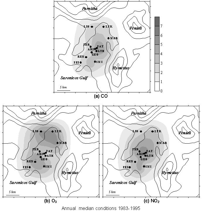
Further analysis of spatial variation showed strong dependencies on traffic volumes, on land use (pollutants in urban areas tend to reduce ozone concentrations) and population densities in particular. (Figure below, with the scale 1-7 corresponding to the Index in Table 1)
Temporal variations were also significant,
seasons being characterised by different emissions (patterns of travel and
heating of buildings changing), photochemical activity, wind and rain. ��
The above discussion shows that in order to adequately describe air pollution, indexes such as those of Table 1 need to be derived for specific areas, utilising best available data for emissions.� �In the event that indicators are required for impact upon, for example vegetation, or population the distributions of these needs to be known.� Utilising average figures over the metropolitan area will, as we have seen, be inadequate.� We therefore need the ability to synthesise various layers of geographical and socioeconomic data.� We choose the raster format to represent the spatially discretised indicators, and thus need to:
The remainder of the paper outlines software developed for ArcMap.� ArcMap� provides on-the-fly transformation of projections and its display capabilities allow ready verification of processing in the tools that were developed with ArcObjects.
Software has been developed to support the first step in deriving sustainability indicators associated with each cell of a raster. Examples of inputs to sustainability indicators are total lengths of roads, total areas of fresh water and total populations � 1-D, 2-D and 0-D data respectively.� In order to derive indicators for each cell of a raster, sampling is necessary to obtain the contributions to each raster cell.
Efficiency is clearly enhanced by achieving this is one operation for all cells, rather than sampling data for each cell in turn.
The goals of the initial software development were to:
� �create additional tools in ArcMap to derive spatially indexed feature data, where each feature is within one cell of� a template-raster (that defines cell sizes, and raster extent and projection) and includes an attribute indentifying the associated raster cell.
� �allow data for each feature (including area or length as appropriate) to be written to a text file and exported for further processing, using the indexing attribute as a key.
It is achieved as follows, using ArcObjects:
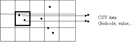
�The CSV file enables generic processing tools to further analyse the data.� The data comprise a cell index, a quantity (length/area/value for line/polygon/point data respectively) and possibly additional attribute data.
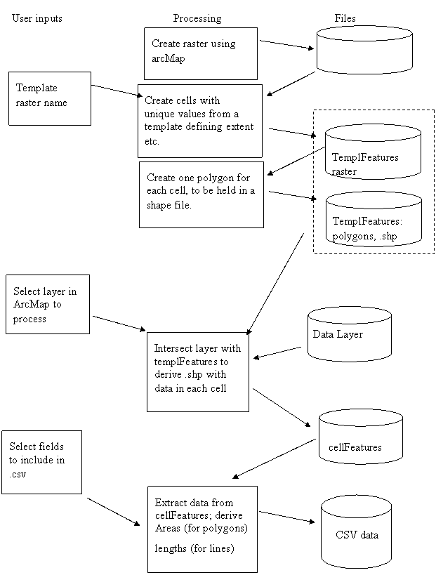
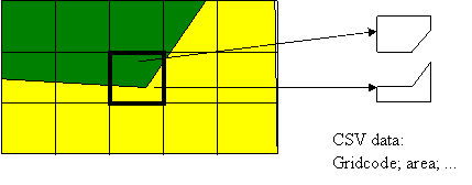
Features comprising areas are processed as described above, by� intersecting the data with the templateFeatures to derive features within each template cell.� This is to be done using a map and data in the Lambert-Azimuthal projectin.� Results in the CSV file comprise the area of each cellFeature, and the attributes previously associated with the feauture.
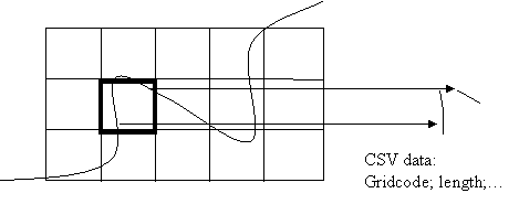
Features comprising lines are processed as described above, by� intersecting the data with the templateFeatures to derive features within each template cell.� This is to be done using a map and data in the Lambert-Azimuthal projection.� Results in the CSV file comprise the length of each cellFeature, and the attributes previously associated with the feature.
Features comprising points are processed as by� using a map in geographical coordinates, and inferring the gridcode associated with each point from its coordinates.� The cellFeatures thus comprise the same dataset, with additional fields of information (the gridcode). Results in the CSV file comprise the value at each point, together with its coordinates and the attributes previously chosen
Points outside the template are given gridcode -1.
Concerns about the use of indicators for environmental sustainability have been discussed. Amongst these the need for appropriate spatial resolution was emphasised� with reference to the characteristics of air pollution in metropolitan areas.
As a first step towards generating spatially discretised indicators, software that utilises ArcObjects has been developed.� The software intersects features and polygons corresponding to raster cells, exporting the resulting areas/lengths/values (for polygon, line or point input features, respectively) for external processing. The software will be used both in understanding observed patterns of pollution and in exporting suitably spatially referenced data as inputs to the indicators.
A.N. Skouloudis and P. Kassomenos, 1997,� �EMMA Air Quality Indicators�, Users Requirements Report. EN 1005, DGXIII, pg. 87.
P.Kassomenos, H. Flokas, A.N. Skouloudis, S. Lykoudis, V. Asimakopoulos, M. Petrakis,1999; "Status of Air-Quality at the Athens Metropolitan Area from 1983-1995; Relationship between synoptic scale atmospheric circulation and air-quality indicators�, Atm. Environment, Vol 33, pp 1861-1879.