Paper Title: Web-Based
Data Distribution Systems
Author: Mr.
Don Murray
Presenter: Dr.Kevin
Wiebe
Abstract
This paper
describes the challenges and benefits surrounding a web-based data distribution
system.
Implementing a web-based
spatial data distribution can be a challenge, but many organizations are doing
it successfully and reaping the benefits. Before enterprises undertake such
projects however, they must first allocate time to understanding the quality
of their data, and the target audience.
Traditionally, it has been
very difficult for an enterprise to consolidate its disparate map data into
a single, seamless database, and integrate this significant asset into the decision
making process. For the past 30 years, organizations around the world have been
capturing spatial data digitally in a wide variety of data formats. With thousands
of data formats, sharing mapping data is a complete process. Industry sectors,
governments, and even departments often work in data formats that most appropriately
address their needs.
Recent developments in spatial database technology from a variety of vendors
are making it possible for organizations to realize the dream of integrated
spatial and attribute corporate databases. Although the transition from mapsheet
files into a spatial database can be difficult, many organizations are now successfully
doing this in order to leverage their significant spatial data investment. This
article provides guidance in preparing for such a migration, independent of
spatial database type.
Web-Based
Data Distribution Systems
Quick links:
Overview
Spatial Database-Based
Open
and Standards-Based Architecture
User-Directed
Scalable
Secure
Reliable
Cost-Effective
Summary
SpatialDirect
and Esri ArcIMS Support - How it works
Case
Study
Presenter
Biography
Company and Contact Information
Overview
Spatial
data is being used by an ever-increasing number of organizations · from
city to national governments, and from small companies to large corporations
· who all view spatial data as a strategic asset. As spatial data increases
in importance, both businesses and governments need to disseminate and have
access to the latest data as cost-effectively and as fast as possible.
As the need for spatial
data grows, there is also an increasing number of web-based mapping systems
that enable users to view data, and perform simple analyses and other basic
GIS operations. The focus of these mapping systems was on providing GIS-based
functionality over the Internet/intranet; however, the products have a limited
native ability to distribute data.
Historically, spatial data
has been distributed using physical media; and, since spatial data is voluminous,
data providers were often forced to provide the data in a single format and
a single coordinate system. As a result, data consumers who wanted the data
in a different format or coordinate system had to convert the data either by
writing customized software or by using a commercial data translator such as
Safe Software's Feature Manipulation Engine (FME) or Blue Marble Geographics'
Geographic Translator.
The growth of Internet and
web-based technologies provides new distribution possibilities for spatial data
users and providers. Web-based data distribution products, such as Safe Software's
SpatialDirect for ArcIMS, are now hitting the market.
When you are choosing a
web-based data distribution product, you will need to consider some key points
to ensure that the system satisfies both your immediate and future needs.
Top
Spatial
Database-Based
Spatial database-based systems
provide superior performance in addition to the benefits of a Relational Database
Management System (RDBMS). While it is possible to distribute data via the web
from data holdings that are not stored in spatial databases, spatial databases
such as Oracle Spatial and Esri's ArcSDE, provide much better functionality.
Web-based data distribution
systems that are built on spatial databases are also in no way limited or complicated
by file boundaries or other tiling issues: the complete data holding can be
represented as one contiguous dataset. The first generation of web-based data
distribution systems often requires that all the data be periodically dumped
into a proprietary file format. This restricts first-generation systems to smaller
datasets and to systems that do not require live updates. It also means extra
work is necessary since the data has to be copied from the data source to the
web-based format on a regular basis.
Top
Open
and Standards-Based Architecture
The web-based data distribution
system must be based on OpenGIS® Consortium (OGC) standards so that it can
easily work with other standards-based products, and have an open architecture
that enables integration with third-party products.
In particular, the web-based
mapping server should be able to act as both an OGC Web Mapping Server (WMS)
and an OGC Web Feature Server (WFS).
The Web Mapping Server specification
is the simplest of the OGC Web Services. It defines three operations:
- GetCapabilities (required):
Obtain service-level metadata, which is a machine-readable (and human-readable)
description of the WMS's information content and acceptable request parameters.
- GetMap (required): Obtain
a map image whose geospatial and dimensional parameters are well defined.
- GetFeatureInfo (optional):
Request information about particular features shown on a map.
The OGC WFS specification
defines the following operations for a Web Feature Server:
- GetCapabilities (required):
A web feature server must be able to describe its capabilities. Specifically,
it must indicate which feature types it can service and which operations are
supported on each feature type.
- DescribeFeatureType (required):
A web feature server must be able, upon request, to describe the structure of
any feature type it can service.
- GetFeature (required):
A web feature server must be able to service a request to retrieve feature instances.
In addition, the client should be able to specify which feature properties to
fetch and should be able to constrain the query spatially and non-spatially.
- Transaction (optional):
A web feature server may be able to service transaction requests. A transaction
request is composed of operations that modify features (that is create, update,
and delete operations on geographic features).
- LockFeature (optional):
A web feature server may be able to process a lock request on one or more instances
of a feature type for the duration of a transaction. This ensures that serializable
transactions are supported.
The OGC divides WFS implementations
into two categories:
- Basic WFS -implements
the required operations (a read-only implementation), and;
- Transaction WFS -adds
the Transaction capability, and possibly the LockFeature capability, to the
Basic implementation.
When selecting a web-based
data distribution system, it is definitely worth knowing what level of compliance
the system has with the OGC and what the future direction with the product is.
Top
User-Directed
The data export operation
must allow the user to select the data to be exported. This should, at a minimum,
allow the user to do the following:
- view the data
- perform simple mapping
operations such as pan and zoom,
- select the themes that
are to be delivered,
- select the format for
the delivered data,
- select the projection
for the delivered data,
- specify the geographic
extent of the delivered data.
Once the data is selected,
the system should only send the data that the user selects. This requires the
system be able to do on-the-fly data extraction, and data clipping. It's a more
efficient use of communications bandwidth if as little data as possible can
be packaged for shipping to the user.
Top
Scalable
The system must be able
to satisfy clients using the smallest single CPU machine data distribution systems
to large clients using multi-machine systems, and must be able to easily grow
from one extreme to the other without causing organizations to lose their investment.
The architecture must thus be flexible enabling software components to be easily
moved from one machine to another with minimal change to configuration files.
Top
Secure
The system must be secure
in two ways:
- it must not allow users
to see any restricted data, and
- it must guard against
requests for too much data that, if processed blindly, would result in loss
of or degradation in service.
Since the Internet can be
a very hostile environment, there must be a layer of software between the underlying
database and users, ensuring that users cannot find ways to sensitive data.
If the system detects any attempts to thwart the security, then it should log
this information with as much user and/or IP information as possible, and notify
system operators.
The system must also be
capable of handling requests for too much data. For example if there is a theme
named "Roads" that contains all the roads in the continental United
States, the system should guard against a misinformed or hostile user that requests
all the roads for a particular state or for the whole country. This is too much
data for a real-time request and processing such a request would greatly degrade
the system performance.
Ideally, systems administrators
should be able to define the size of data that is to be distributed on a layer-by-layer
basis and provide for different levels of service based on the amount of data
that is requested. An example of one possible set of different levels is described
below:
- Real-time Service: This
is for small requests. This value is dependent on a number of factors: server
bandwidth, client bandwidth, number of expected simultaneous clients, and throughput
of server. For these requests, the system processes the request immediately
with a turnaround time that would be acceptable for a user waiting at a browser.
- E-mail Service: These
requests are the next level in size. The server still processes the requests
immediately, but it is recognized that the delay is beyond the threshold of
a user waiting at a browser. The user is sent an e-mail message with an ftp
link that points to the extracted data.
- Physical Media Service:
This level of service is for data requests that are performed off-line and then
put on physical media. These results are deemed to be simply too big to be sent
via the communication infrastructure.
Prohibited Service: This
is for requests that are deemed too large to process. The request is logged
and the client is simply notified that the data request is too big for the data
distribution system.
Top
Reliable
The system must be reliable,
and at the same time it must have an administrative capability that catches
and reports faults. It must also have a statistics reporting capability so that
administrators can see how the system is performing. If any bottlenecks exist;
administrators need to know where they are located so that future performance
issues can be identified before there is a serious impact on the users.
Top
Cost-Effective
The data distribution system
must be cost-effective, providing a cost based on server configuration or number
of concurrent users and not on the total number of users.
The data distribution system
must also be able to be used without requiring software be installed on the
client machine. For Internet-based solutions, it is best if the software can
run from a standard browser such as Internet Explorer or Netscape without requiring
plug-ins.
Top
Summary
The move to web-based data
distribution systems builds on the trends to move spatial data into databases
and GIS functionality to the web. When choosing a web-based data distribution
system, an organization must ensure that the system meets both their immediate
and future needs. The chosen data distribution system must have an open architecture
and must adhere to industry standards so that it can easily work with the web
mapping solutions from both current vendors and future standards-based products.
The product must be scalable so it can grow with the need to distribute data.
It must also be priced on server configuration and not on number of users so
that it remains cost-effective. This way, the deploying organization can benefit
from the continual decline in computer hardware pricing.
Top
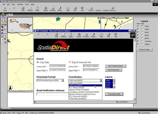
SpatialDirect and Esri ArcIMS
Support - How it works
SpatialDirect is a Web-based data delivery system, enabling users to distribute
data from their ArcIMS system. Users can specify an output data format from
dozens of GIS, CAD, and database formats. Additional information and demonstrations
available at www.spatialdirect.com.
| |
|
Step
1 |
|
|
|
|
|
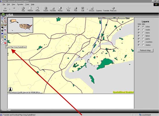
The
SpatialDirect ArcIMS for Esri integration adds a "download"
button to your applications toolbox.
|
|
Click
on the SpatialDirect icon to display a Download Manager box.
|
| |
|
|
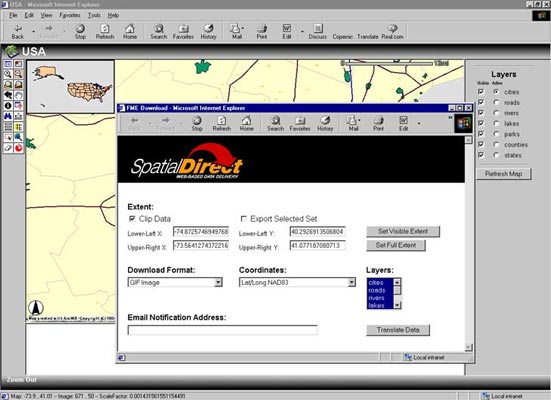
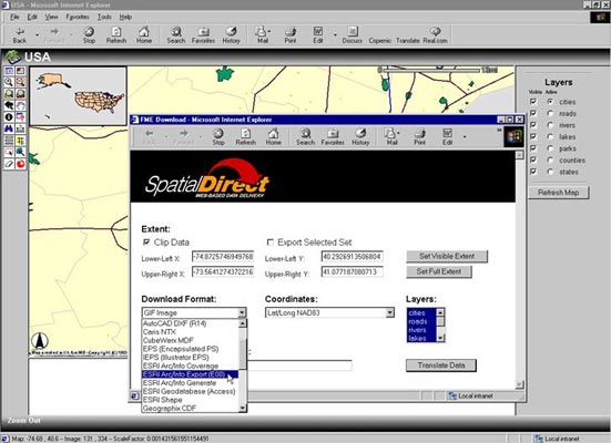
| Step
2 |
|
Step
3 |
|
|
|
 |
|
Select
an output format.
|
|
Choose
a coordinate system, and press the Translate Data button.
|
| |
|
|
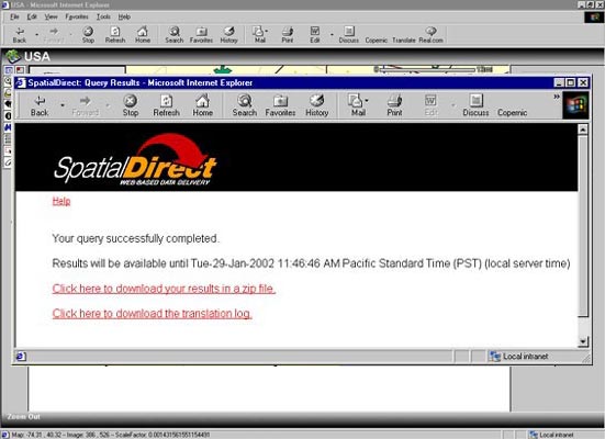
| Step
4 |
|
Step
5 |
|
|
|
 |
|
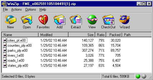
SpatialDirect
clips the data, zips the data....
|
|
...and
ships the data - right to the desktop.
|
| |
|
|
Top
Case
Study
The following solution
was achieved by a Safe Software customer using SpatialDirect:
EnCana (formerly PanCanadian)
/ IHS Energy Case
Situation
Safe Software worked with EnCana (formerly PanCanadian) to integrate ArcSDE
data with IHS Energy's Oracle Spatial database, and deliver it in real-time
using their web-based data distribution system MapWiz. A key issue included
inconsistency between systems, which hindered data access and the ability to
share information.
Challenge
The new web-based system had to allow users to quickly, easily, and consistently
access up-to-date information from different storage centers. Data then had
to be securely retrieved and distributed accurately over the network, all in
real-time. Implementing any new system required that work-flow disruptions were
kept to a minimum, and that the company could measure a reduction in cost and
time.
Solution
EnCana identified Safe Software's SpatialDirect as the best solution for its
needs. Safe Software assembled a small team of developers to customize and implement
its web-based data delivery system. Details of the design, implementation, obstacles,
and the end results of the project will be discussed.
Top
Presenter
Biography
Dr. Kevin Wiebe
received his Ph.D. in image manipulation and translation from the University
of Alberta. He has been a University Computer Science instructor and is also
an experienced Software Engineer. Dr. Wiebe has worked at IBM as well as Sony's
Research and Development lab in Japan, and currently leads the formats development
team at Safe Software Inc. in Surrey, BC, Canada.
Top
Company
and Contact Information:
Author: Mr. Don Murray President,
Safe Software, Suite 2017-7445 132nd Street Surrey, BC Canada V3W 1J8
Presenter: Dr. Kevin Wiebe, Lead Developer, Safe Software, Suite 2017-7445 132nd
Street Surrey, BC Canada V3W 1J8

Safe Software provides data translation
solutions. The company's products and services allow organizations to translate,
share and enhance their spatial data between over 100 GIS, CAD and database
formats. Users can choose to receive seamless data delivery to their desktop
or over the Internet.
Safe Software
Suite 2017 7445- 132nd Street
Surrey, BC, Canada
V3W 1J8
Ph: (604) 501-9985
Fax: (604) 501-9965
info@safe.com
www.safe.com
Top