Enhancements to the DLA Electronic Catalog of NIMA Maps, Charts and Related Products
Paul Christensen
ABSTRACT
This paper is an overview of the very first custom MapObjects - Java application. This project is the next generation for the Department of Defense Catalog of National Imagery and Mapping Agency (NIMA) Maps, Charts and Related Products produced by Defense Logistics Agency (DLA). By utilizing MapObjects - Java, DLA, in partnership with Environmental Systems Research Institute (Esri), has produced an extremely user-friendly electronic catalog of all available NIMA Global Geospatial Information & Services (GGI&S) products. The graphical user interface (GUI) allows the most novice catalog user to locate the desired maps, obtain all attributes for those maps and then electronically order the necessary maps from the Defense Supply Center Richmond (DSCR).
BACKGROUND
In April of 2001, Defense Logistics Information Service (DLIS) released the first electronic version of the Department of Defense Catalog of NIMA Maps, Charts and Related Products on a CD. This electronic catalog (E-cat) utilized a hypertext markup language (HTML) and represented all previous hardcopy NIMA Geospatial Information & Services (GI&S) product catalogs. It was a great improvement over the hardcopy paper catalogs that were very cumbersome to produce, maintain and use.
Hardcopy paper catalogs required customer knowledge such as country location, product availability, and map scale. This research entailed flipping back and forth through all of the different catalogs (topographic, aeronautical, digital, hydrographic, etc). Next, the customer had to manually write down the NIMA Reference Number (NRN) and use a cross-reference table to find the National Stock Number (NSN) needed to order the map. Finally, they had to fill out a Military Standard Requisitioning and Issue Procedures (Milstrip) order and send it to Defense Automatic Addressing System Center (DAASC) in Dayton, Ohio.
Developing and
prototyping an HTML based catalog was the brainchild of Nick Bekanich of NIMA's
Analysis and Production Directorate. Mr. Bekanich passed his design
recommendations, software, and test data to Defense Mapping School
personnel who then passed it directly to DLIS. DLIS recognized the advantages of the
recommended design and made it a reality.
Steve Jalbert, on
DLIS' NIMA Catalog Team, was instrumental in making the E-cat a reality. This first E-cat
provided a digital representation of all NIMA hardcopy and media-based product catalogs.
The
customers now had a compact
Enhancements to the Electronic Catalog (E-cat)
While the E-cat was a great step forward, I felt that it still had room for improvement. The customer interface needed to be simplified and more intuitive. The map search utilities needed to be much more capable than the current E-cat. I proposed that we change the customer interface to utilize icons and drop-down menus rather than building SQL queries. With our varied customer base, it is unreasonable to expect everyone to be able to build an SQL query, to know the U.S. State Department Country Codes, to know the proper spelling of country names, or to know various country locations.
I felt that interactive tools were necessary that allowed click-and-drag radius, route, and rectangles. I shared my ideas with Michael Hodge of NIMA's Information Services Directorate and he recommended an interactive tool which would allow customers to perform Boolean queries by a click-and-drag irregular polygon. Also needed was a dialog box that allowed the customer to select by geographic coordinates, map series, and major command areas for specified map products.
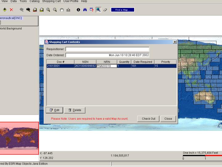
Another quantum leap forward is the ability to electronically order over the web. With this new application, the user can browse the catalog, select map products and then add them to their virtual shopping cart. The shopping cart is an editable listing that can be electronically routed to the correct depot. This portion eliminates the tedious requirement of writing down the NRNs, translating to the NSNs, filling out the forms, and mailing them.
I compiled the list of requirements and contacted Esri to create the custom application that would provide these capabilities for our customers. I contacted Dave Brooks of Esri's Washington DC Defense Group and he reviewed the requirements and recommended Lee Peterson at their Redlands' office. Lee manages a unit that works on a variety of Department of Defense programs and was currently working with the Marine Corps on a custom application for them. After speaking with Lee, he felt that Esri could develop a custom product based on their new MapObjects - Java application. Brian Levy, along with Ivan Cheung, and Mingji Chu created the superb custom application for us. This is a milestone for Esri as well, as it is their very first custom application developed using MapObjects - Java.
Below is a screen shot of the front page of the application:
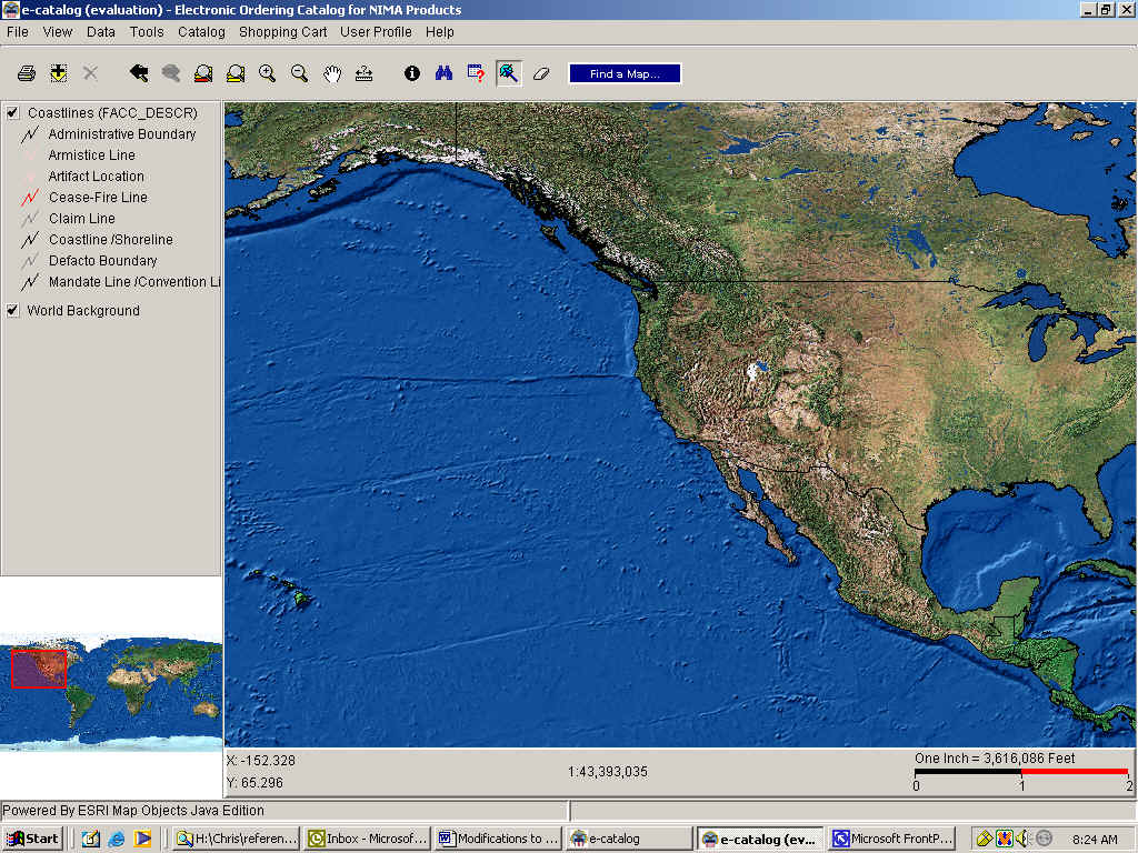
Find a Map
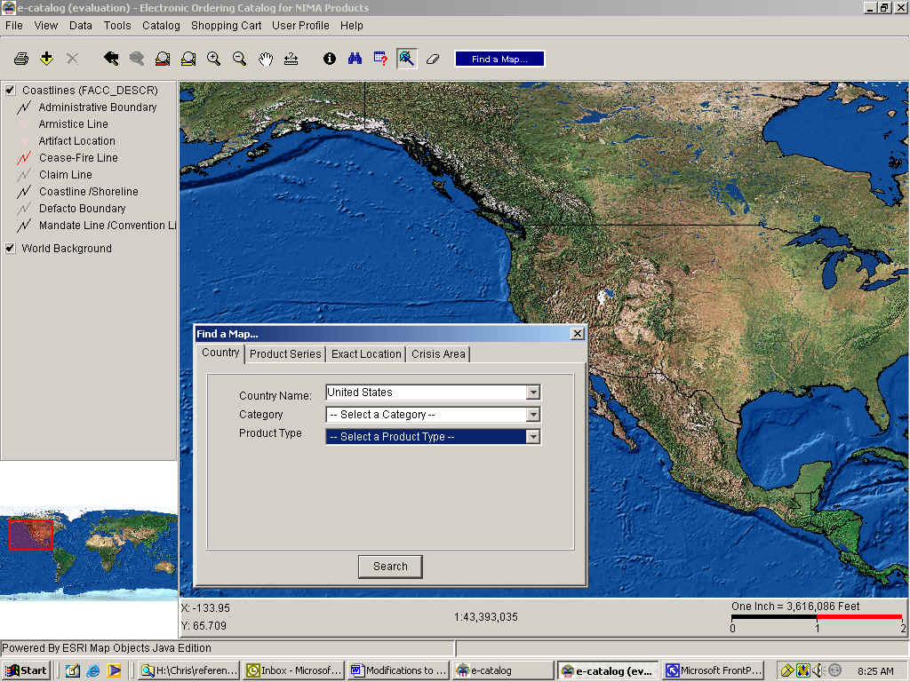
I required a very visible/intuitive icon and termed it 'Find a Map'. After clicking on this icon, the customer will see a dialog box which has tabs that would allow them to search for a map by drop-down menus that listed all of the countries of the world, all of the available map series, and the major military command areas.
Also, by utilizing interactive tools, they would be able to geographically define a bounding box or a point and radius by degrees-minutes-seconds, decimal-degrees, or UTM. Another drop-down menu would provide the customer with interactive tools such as a click-and-drag bounding box, point and drag radius, a route defined by a polyline, and an irregular polygon. Once an area is defined, the user then clicks on the product category (topo, aero, digital, or hydro) on a drop-down menu. Next the customer selects the product type (i.e. - JOG, TPC, TLM, City) and clicks 'search' to begin the query. The display zooms in to the defined area and the requested items are highlighted. The items can then be added at will to the shopping cart.
Menus
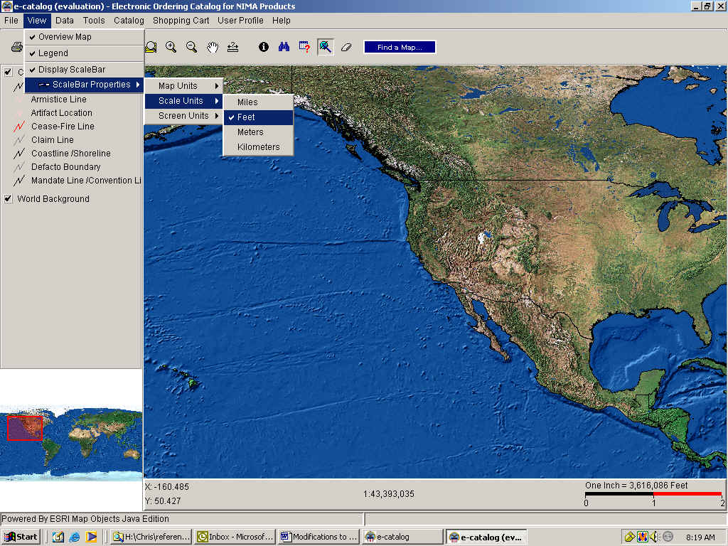
Under the VIEW menu, the legend, display and overview map can be turned on or off. The user can change the symbology for each layer within the legend and define the units for the display. When the customer zooms in on an area within the display, the overview map references the display area with a red bounding box.
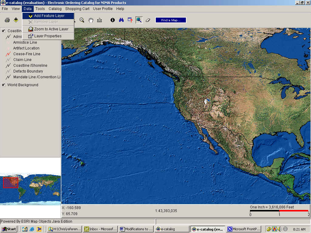
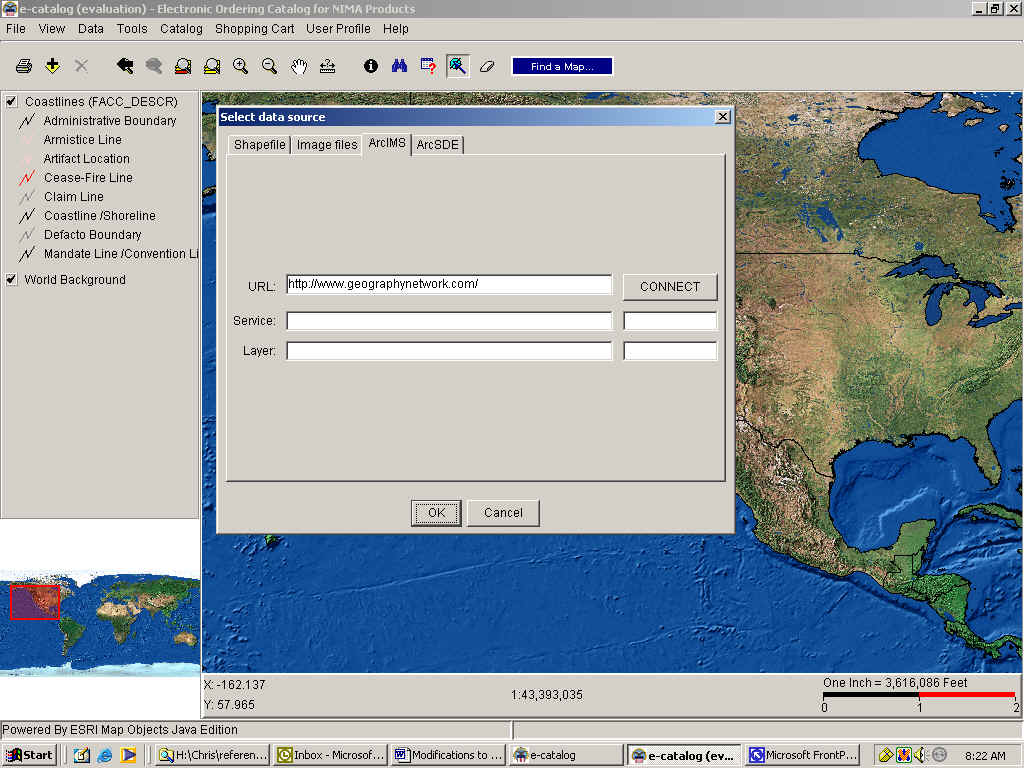
Under the DATA menu, layers can be added to or deleted from the
legend. The 'Add Feature Layer' option is a very powerful tool for the
customer. This option allows the customer to add shapefiles, images, or data from
external sources. The external sources can be a Spatial Data Engine (SDE)
or an Arc Internet Map Service (IMS) URL. Once the DLIS E-cat website is
operational, this will enable our customers to download the most current data
whenever they desire. They
will no longer require a CD for updates nor will they have to wait a month for
the next Edition release as updates will approximate real-time.
The catalog customer can define all of the layer properties (i.e. symbol color, size, shape, visibility and position). They can also define the label's font size, style, and scale range for display. 'Zoom to active layer' is also available under this menu.
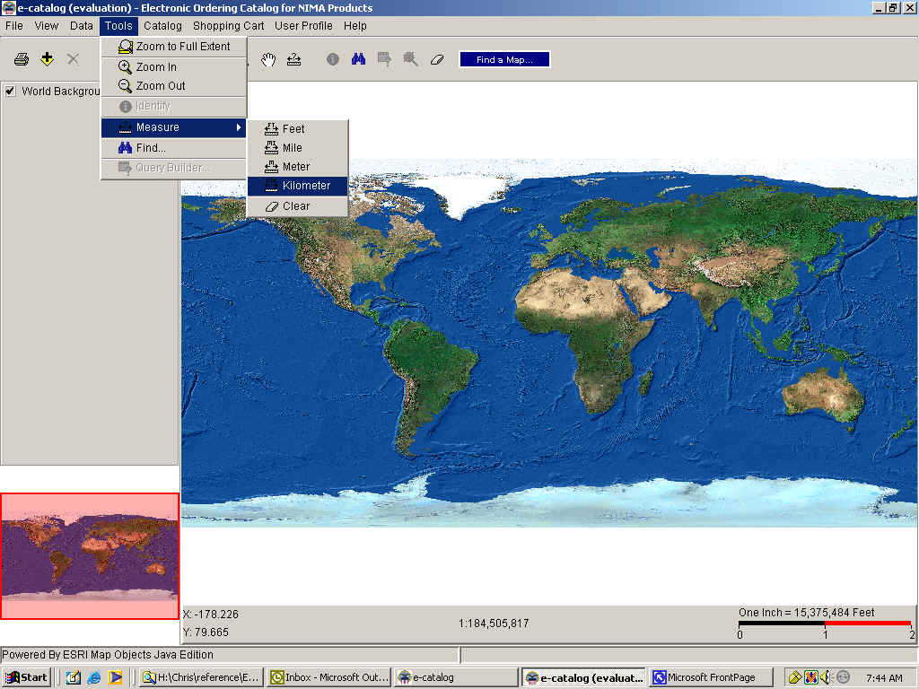
Under the TOOLS menu, the catalog user has zoom capability, can identify map items from the current highlighted layer, measure distances by a variety of units, find an item by specifying a value within any field of attributes or by building a traditional SQL query. With these tools, they can locate a certain NSN, NRN, country, or build an SQL query that will define all products that fulfill a very specific need.
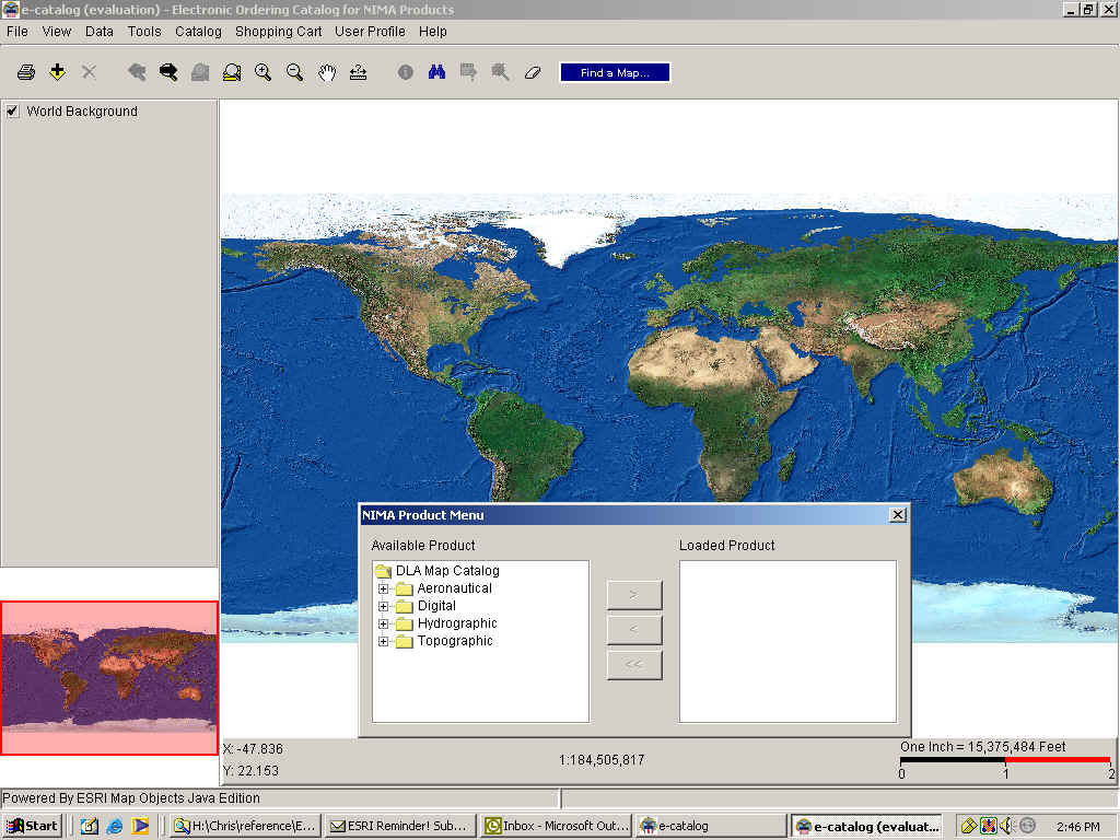
Under the CATALOG menu, the user can access the 'Find a Map' option. It gives them another route to get to the same option. The 'view search results' brings up the window that shows which products are currently selected within the display. The last item, NIMA Product Menu, displays a window that lists all of the map product layers available in the catalog. They can transfer them to the legend and display by moving them to the loaded product column.
The SHOPPING CART menu, offers the options of viewing the shopping cart or to launch Web requisitioning (WebReqs) which is the avenue for online ordering.
Under the USER PROFILE menu, the user can manage the user profiles. This allows them to create a custom profile, edit an existing profile, or select a user profile from a drop down list for the current ordering session. The user profiles are used to auto-populate the information specific to the requisitioner in the Milstrip order. Multiple users can use the same system and each individual user can set up and use a custom profile to order map products or multiple users can use a single profile. This allows for greater flexibility and time savings for those who repeatedly order map products.
Under the INFORMATION menu, you will find all of the general textual information. It contains a tutorial on how to use the catalog, a dictionary of terms used within the catalog, ordering procedures, agency points of contact, reference tables, frequently asked questions (FAQ), look-up tables, electronic web links, special notices and a list of changes from the last edition.
Ordering a Map
If the catalog user has Web connectivity, they can electronically order the maps they need once they have set up the appropriate accounts. First, they select a map product, which is then added to a selection list. Next, add it to the shopping cart by simply highlighting one or more items on the selection list and clicking on the 'Add to Cart' button. When the desired products are added to the shopping cart, the catalog user is able to set the shipping priority code, copies needed, and the date they are needed. To complete the ordering process, they click the 'Check out' icon, which opens a Webreqs link and a Milstrip order is automatically completed and sent to DAASC. DAASC then automatically routes the digital order to the correct depot for completion.
If the catalog customer does not have Web connectivity, they can print out a completed hardcopy form and send that to their supply person or use their proper hardcopy channels.
Whether or not the user has connectivity, the new ordering process is a vast improvement over the days when the user was required to copy all of the numbers down on a piece of paper and hope that they did not transpose any numbers.
Conclusion
This custom MapObjects - Java application is the next generation "Department of Defense Catalog of NIMA Maps, Charts, and Related Products". DLIS will continue to improve this product and intends to make it the most complete, accurate and timely product possible for America's military.
Author Information
Paul B. Christensen, Cartographer, Dept. of Defense, DLIS, 74 Washington Ave. N, Battle Creek, MI 49058, (616)961-4773, fax (616)961-4983, email pchristens@dlis.dla.mil