An Integration of GIS Technologies for Ice Hazard Warnings:
Awtar Koonar and Brian Scarlett, Ice and Marine Services
Branch, Meteorological Service of Canada
This paper presents the current and future application of mission-critical
GIS technology in the Canadian Ice and Marine Services Branch (IMSB) for
supporting the marine community. IMSB provides timely and accurate ice
information for day-to-day decision support in Canadian waters. The acquisition,
processing and integration of real-time data is essential for this task.
A typical day at the IMSB involves the real-time acquisition, processing,
and analysis of geographic data; the integration of vector, raster, and
alphanumeric information; generation and the dissemination of text,
chart, image and spatially enabled products to clients and partners. All
products are deposited in a central repository and are made available
to public and partners via a geo-spatial web service.
IMSB is also responsible for an extensive archive of the Canadian maritime
cryosphere; specifically sea ice, lake ice and icebergs. This information
is an integral component of monitoring global climate variation since the
cryosphere is especially sensitive to minute changes in environmental conditions.
The Ice and Marine Services Branch (Canadian Ice Service)
The Canadian Ice Service of the Meteorological Service (MSC) of
Environment Canada is responsible for providing sea ice and iceberg information
under the Canadian Federal Ice Program.
Water transit is vital to the economy of Canada. Each season,
ships face many challenges traveling the waters of the Gulf of St. Lawrence,
Labrador Sea and the Arctic Ocean. Ice floes and icebergs clog
shipping lanes, delaying transit and creating hazards for both the ships
and those on board. These floes and icebergs can also damage drilling platforms
and fishing vessels and are hazards for northern communities.
To fulfill its mandate, the Ice and Marine Service Branch (IMSB)
in Ottawa, Canada is dependent upon integrated GIS and supporting technologies
for the rapid processing and dissemination of navigation products generated
from the data acquired from satellites, airborne radars, ice/ weather models
and other data sources. The Integrated Spatial Information System (ISIS)
satisfies the IMSB requirement for a system which is reliable in a real-time
production environment yet flexible and scalable to adapt to new data sources,
products, platforms and evolving business requirements.
The ISIS is built around a core of commercially available software packages
which have made it easier to incorporate established and evolving geospatial
standards and to integrate, generate and disseminate a wide variety of
GIS based products.
The IMSB provides a variety of services including;
-
daily ice hazard warnings and charts describing ice conditions in active
navigable waters
-
warning service for extreme ice events
-
weekly and monthly analyses of all Canadian ice covered waters for transportation
planning, climate monitoring and sustainable development
-
an ice and iceberg archive for climatological studies
-
and contribution of Canadian ice data to the World Data Centre for Glaciology
Integrated Spatial Information System: Functionality
As illustrated by Figure 1, ISIS can be viewed as being comprised of seven
subsystems, each providing the following functions:
-
Data Acquisition Subsystem receives data from different sources
and platforms, distributes data to other systems, triggers ice models or
classification tasks, performs automatic geolocation, performs image compression,
enhancements and contouring of satellite, imagery and model outputs and
stores everything in a central data repository. Load balancing, distributed
databases and parallel computing are used to meet daily processing requirements
and for meeting strict production and delivery deadlines.
-
Data Management and Metadata Repository is composed of a relational
database management system (RDBMS) and a database based upon the Content
Standard for Digital Geospatial Metadata (CSDGM) as defined by the US Federal
Geographic Data Committee (FGDC). The repository ensures the metadata access
to the records is controlled and constraints are strictly enforced. The
repository is comprised of a catalogue which is streamlined for a daily
production environment and long range catalogue for archiving and trend
analysis.
-
Ice Analysis Subsystem is the high-end ISIS workstations that provide
access to all data referenced by the Metadata repository. Custom tools
are developed for sorting, displaying, and analyzing of data in order to
generate electronic and hardcopy products such as navigation charts and
bulletins. Analysts can enhance imagery and then annotate with text and
line objects to reveal ice characteristics and iceberg targets. This
client/server subsystem is based on high availability UNIX servers and
Windows 2000 clients and makes extensive use of ERDAS Imagine, ArcGIS
and ArcView3 software. There are three primary components
of this subsystem;
-
Geospatial Metadata Browser is a visual directory of the
real-time data repository. A user can view metadata associated with a data
object in a tabular format and/or graphical format showing the coverage
'footprint'. A variety of temporal and spatial data filters are available
for data discovery and drilling. With geospatial metadata the footprint
of the data can be superimposed on a globe which allows the user to see
the geographic context of the data.
-
the Image Analysis component provides the user with multiple
image display, analysis using Esri shared libraries, mosaics and
generation of annotated image products.
-
the Data Integration and Product Generation component integrates
GIS data from various sources including model prognosis, previous or archived
analyses, analyses from partners and observations from ships, aircraft
and remote operation offices. Topology and product generation as defined
by World Meteorological Organization (WMO) standards and business rules
are integral within this component.
-
Berg Analysis and Prediction Subsystem is comprised of three software
components; Geospatial Meta Browser, Image Analysis and Iceberg Product
Generation. The Browser and Image Analysis
are identical to the Ice Analysis Subsystem.
-
Iceberg Product Generation provides capabilities for validating
and correcting iceberg locations received from aircraft and ships, integrating
recently reported icebergs with Most Recent Observation File (MROF), generating
now cast and prognosis products based on model outputs and MROF.
-
Product Dissemination Subsystem receives products generated by Ice
Analysis Subsystem or from other systems, formats these products based
on client profiles and then delivers via their preferred communication
methods such as FTP, e-mail or Fax. A product database and client standing
orders maintain all deliveries and provide tracking and performance details.
The subsystem supports delivery in GeoTIFF, MrSid, PDF, Encapsulated PostScript,
JPEG, GIF, bundled Shapefiles, Esri export files and ERDAS IMG formats.
-
Field Decision Support Subsystem is the low-end ICE-VU workstations
that are deployed on Canadian Coast Guard (CCG) vessels, remote ice operation
offices, on board reconnaissance aircraft, and at the IMSB. ICE-VU workstations
were designed specifically as marine decision support applications and
provide Coast Guard and Ice Service Specialists with the capability to
receive real-time Synthetic Aperture Radar (SAR)/ Side Looking Airborne
Radar (SLAR) data or to download compressed MrSID imagery and GIS products
provided by the IMSB. ICE-VU is stand-alone system and has its own data
acquisition, processing and catalogue functions to enable user to plan
navigation routes and deviations.
-
Climate Support Subsystem provides access to operational analysis
tools for meteorological and ice trend analysis and support for analysts
producing long range forecasts and seasonal outlooks. This subsystem has
direct access to long range archive repositories, based on CSDGM Metadata
search criteria. It supports other tools for producing ice climate products
and an annual ice atlas.
-
Data Order Subsystem provides tools for planning aircraft flight
paths, planning data transmissions during flights to ships and to Ice Reconnaissance
Data Network (IRDNET) ground stations for subsequent broadcasts to CCG
and MSC. This subsystem also provides tools for planning Radarsat and ENVISAT
data acquisitions and for ordering data frames to meet IMSB operational
requirements.
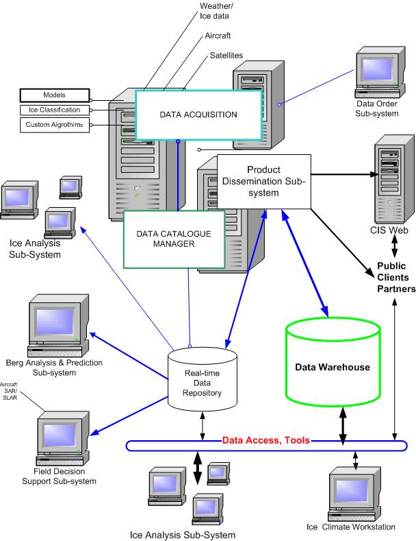
Figure 1: Integrated Spatial Information System (ISIS)
Integrated Spatial Information System: Architecture
As illustrated by Figure 2, ISIS software architecture is based on four
layers;
-
Layer 1 – Application Layer that provides Human Machine Interface (HMI)
and data interfaces to meet business requirements based on operational
workflow and scenarios. This layer makes extensive use of components in
the service layer.
-
Layer 2 – Service Layer that provides reusable software components and
common system wide functions. Examples of service components are, print/plot
services, malfunction detection/reporting, error reporting, logging, communication
software, Database services, interfaces to COTS, Help facilities, etc.
This layer also contains encapsulation modules for interfacing with various
models.
-
Layer 3 –Architecture Layer that provides generic mechanisms and structures
for managing data and control for the system as a whole. This layer also
contains RDBMS, commercial software and functions required for distributed
processing and parallel processing.
-
Layer 4 – Implementation Layer which defines hardware platform, operating
systems, networking environment, and storage networks.
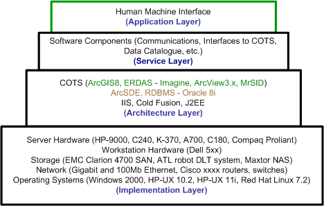
Figure 2: ISIS Software Architecture
Integrated Spatial Information System: Moving Forward
This summer, three high-speed Bell Express-Vu direct satellite links will
be installed on coast guard ships, which will enable the cost-effective
transfer of imagery, GIS and other datasets with improved performance.
This will significantly improve the amount of information to navigators
who are often restricted by unreliable and slow analogue connections.
As well, a new OnBoard Analysis Subsystem is in the concept stage. This
subsystem is intended to have capabilities between the high-end ISIS and
low-end ICE-VU Ice Analysis Subsystems. Data integration and analysis will
be based on Ice Analysis Subsystem described above. Visual data entry
will be based on pen computers that will use GIS technology for attribute
and feature inputs and for topology creation. CCG will be installing pen
computers onboard ships and helicopters for generating ice observation
charts.
To assist the IMSB personnel on the aircraft, the OnBoard Analysis Subsystem
will be configured with a small network linking server, workstation(s)
and pen computers. This will allow the analysis of newly acquired SAR/SLAR
imagery in real-time, generate an analysis enhanced by visual and other
sensor data and then transmit the product directly to coast guard ships,
commercial ships or satellite broadcast stations for delivery to IMSB and
to CCG Ice operation offices. Beyond the standard ice duties, there would
be opportunities in which aircraft equipped with the OnBoard Analysis subsystem
could assist in disaster assessment (flooding and pollution) and wildlife
management.
Another area where IMSB has begun to focus is accessible, on-line data
archiving. IMSB is responsible for extensive archive of the Canadian maritime
cryosphere, specifically sea ice, lake ice, and icebergs. This information
is an integral component for monitoring global climate variation since
the cryosphere is especially sensitive to minute changes in environmental
conditions.
Currently the IMSB is saturated with various charts, images, and analysis
and it is necessary to collect all of this together into state-of-the-art
archive accessed through ArcSDE and ArcIMS. ArcSDE and the geodatabase
will provide the centralized mechanism for managing and sharing information
with clients and partners using XML protocols. This archive will be accessible
through Web and other data infrastructures. To provide complete interaction
with the new archive, the IMSB plans to replace the current ArcView3.x
based Browser with a new Visual Basic (VB) and MapObjects (MO) application.
The new Browser will allow the user to query and retrieve information not
only a focused operational catalogue but also a large GIS enabled data
warehouse of cryosphere resources.
IMSB production is based on a product based paradigm in which products
are generated by IMSB staff for specific geographical areas. With a near
real-time data warehouse, IMSB can generate products in the future based
on product and geographic region templates and provide the capability for
generating charts on demand. This approach will require automated tools
for having a continuous spatial database.
The open, scalable architecture of ISIS will enable IMSB and MSC and
their partners to offer new products cost effectively for meeting clients,
public and partners needs and deliver these products via the web as part
of the Canadian e-government initiatives. The ISIS framework can be easily
adapted to implement other applications and disaster management systems
such as pollution control, agriculture, coastal management, flood forecasting,
and many more.
REFERENCES OR ACKNOWLEDGMENTS
Koonar, Awtar, Navigating Icy Waterways with GIS, ArcNorthNews, 2002.
Koonar, Awtar and B.Scarlett, GIS Technology: Canadian Ice and Marine
Service, 2001.
Koonar, Awtar, and Ziqiang Ou, Aircraft OnBoard SubSystem Architecture,
2001.
Koonar, Awtar, and ISIS Development Team, ISIS Conceptual Overview,
1997.
Awtar Koonar, Chief – Technology and Development
Ice and Marine Services Branch, Meteorological Service of Canada
www.ice-glaces.ec.gc.ca
E-mail: Awtar.Koonar@ec.gc.ca