Abstract
The International Centre for Integrated Mountain Development (ICIMOD) through its Mountain Environment and Natural Resources Information Systems (MENRIS) program has been focusing on GIS capacity building and networking of the national institutions in the Hindu Kush-Himalayan (HKH) region to promote the development of geographic information, its sharing and effective use of GIS and RS since early 1990. The development in Internet Mapping technology such as Esriĺs ArcIMS has leveraged the potential to publish geographic and associated information through the Internet. To take advantage of this, an integrated system - ICIMOD Metadata/Data Server System has been designed and developed with an aim to provide a platform to share databases and metadata residing in ICIMOD and its partners and stakeholders through the Internet.
The system includes a metadata editor for customized entering and viewing metadata. The editor has been developed using Visual Basic and integrated within the ArcCatalog environment. It has an easy-to-use interface that is targeted to the groups in the region who need basic but relevant information. A custom XSL stylesheet has also been created to display the metadata information pertinent for MENRIS. The editor produces metadata compatible with FGDC XML format which can be viewed though the Internet browser as a client. Users can view the metadata using the MENRIS stylesheet or other default stylesheets within ArcCatalog such as FGDC, Esri or Geography Network.
Next, a metadata server has been defined. Within it, an ArcIMS 3.1 application has been developed to define information required by a prospective user to determine whether or not the particular geospatial data is available, and the means of accessing them on-line. A keyword search engine has also been made available to view the metadata and the associated data, where available. A major advantage of the system is to be able to use Internet browser as a client to view the metadata with the same look and feel of ArcCatalog, as they are in XML format and also access data on-line through ArcIMS 3.1 application.
The system should help in organising, documenting and sharing geographic data in the region. Its potential will be realized when all ICIMOD partners in the region will join together to publish their data and metadata using the system. Such a network will make it possible for a user to know about any existing geographic information in the HKH region, an important step towards realising the vision of a Regional Geographic Information Infrastructure (RGII). Further, this can contribute to bridging the data gap in the region and aid in global data sharing initiatives such as Geography Network.Com and others.
The International Centre for Integrated Mountain Development (ICIMOD) has been working for poverty alleviation and sustainable development in the Hindu Kush-Himalayan (HKH) region since 1984. It has been promoting the use of Geographic Information Systems (GIS) and Remote Sensing (RS) technology and its applications for sustainable mountain development in the region. The growing awareness of the usefulness of these tools and technology in planning and resources management has increased the demand of these systems. However, the major hurdle faced in successful implementation of projects with GIS is unavailability of appropriate data. The region faces with the isolated development of databases due to the lack of a proper framework. As a result, information is often dispersed, heterogeneous, and inaccessible and the available information is not sufficiently relevant in terms of continuity, reliability and the nature of parameters. Although ample amount of geographic information on the region has been prepared and compiled by various institutions and individual researchers, this valuable information is hardly accessible or shared. Without formal mechanisms for data sharing, much time and resources are wasted in duplication of efforts for data collection and digital data conversion process.
ICIMOD, through its Mountain Environment and Natural Resources Information System (MENRIS) program, has been focussing on GIS capacity building and networking of the national institutions in the region to promote the development of geographic information, its sharing and effective use of GIS and RS in the region. The advent of Internet technology has
revolutionized the concept of networking and information sharing. Internet provides a big potential for efficient and effective ways in obtaining, using and sharing geographic information. The rapid developments in Internet Mapping technology have further leverage the potential to publish geographic information and associated data so that user can have access to them through the Internet.
Mountain GIS Portal ľ a common framework for sharing geographic resources
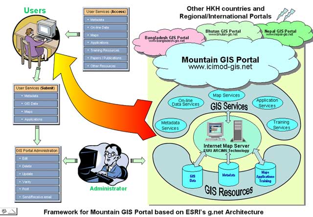
A Mountain GIS Portal has been developed to serve the GIS resources that address sustainable mountain development issues in the HKH region. The portal serves as a common framework for sharing geographic resources in the region. The GIS resources include training and educational resources, database and meta-database resources, map resources, and application resources. More importantly, it is aimed at serving a common platform to access and share information and knowledge about the GIS technology and its applications in mountain development. The portal is envisaged as an important step in accomplishing towards a Regional Geographic Information Infrastructure (RGII) thus facilitating the sharing, integration and use of geographic information across a broad user-base, giving particular consideration to standardised datasets, using the potential of modern information and communication technologies, particularly the Internet. The portal will be a virtual platform for sharing data and information by the users and producers, offering a new one-stop experience for geographic data needs in the region.
Practically, there would be different national nodes linking to the regional portal with similar look and capabilities of the regional portal as portrayed in the figure below. This will take the form of collection of GIS national portals along with a single regional portal. The national portal will give room for National Geographic Information Infrastructure (NGII). In other words the regional mountain portal aimed for Regional Geographic Information Infrastructure will be the aggregation of National Geographic Information Infrastructure. This idea is derived from the g.net architectural vision of Esri, as well. You may recall that g.net is a network-based architecture visioned by Esri that is multi-participatory, collaborative and enabling organizations to openly share and directly use GIS information from many distributed sources at the same time.
Figure 1: Mountain GIS Portal Framework based on Esriĺs g.net architecture
Any user can connect to the portal for accessing GIS services and resources available. These include useful information such as metadata, on-line data, maps, applications, training resources, papers, publications. Users can also submit their data and the above resources. It is not that once submitted the resources are immediately available. The whole portal is managed by a separate, back-end application available for the administrator who verifies, edits if necessary, and then serves them into the portal. The portal thereby has a participatory approach. It is hoped that the portal will be a basis for discussion on use of GIS, sharing data and knowledge for the benefit of mountain people in general, and use of GIS for sustainable development of the HKH region, in particular.At its most basic level, a geographic information infrastructure is realized through a catalog holding metadata about available data. Therefore the role of metadata, metadata server and search tools become critical for the portal. Though there are many important resources being shared via the portal, this paper is focussed on sharing of the metadata and/or data resource via the portal and the technicalities involved.
Metadata are the comprehensive, systematic, and deductive information about the content, structure, relationships, representation, and use context of the data stored in the underlying database. It is a mechanism for informing the people of the existence of data sets or some other form of information.
Metadata are important because they document existing data holdings and act as a focal point for data sharing. They reduce the volume of typically very large spatial data sets to a searchable, while meaningful size. Metadata represent a set of characteristics about the data that are normally not contained within the data themselves and quite frequently only exist in the memory of the persons involved in data collection and use. Metadata provide a synoptic view on what is available in the area of interest, where the information is, what format it is in, and what use constraints apply.
Metadata standard establishes the names of data elements to be used for documenting a data set, the definitions of these data elements, and information about the values that are to be provided for the data elements. The definition of a dataset can also be adjusted to meet a given organization's requirements but it generally corresponds to the smallest identifiable data product (e.g. file) for which metadata are customarily collected.
After going through the different standards and the requirements of ICIMOD, and in view of its institutional affiliations with strategic alliances, it was decided to follow FGDC Ĺstandardĺ with extension. Some additional elements were added to gather metadata pertinent to ICIMOD focus and the region requirements. The basic metadata is compliant with the FGDC standard, even with the additional elements. These additional elements include information on mountain specific keywords, data coverage, simplified projection and attribute information, and some attributes for raster data. It should be noted here that, the standards do provide conversion of common and core elements from one to other.
Simply because so many different standards exist, there are many editing tools along the same line for entry of metadata and enforcing standards. Using ArcGIS via ArcCatalog, metadata can be created with ease and effectiveness. However, we have used a customized metadata editor within ArcCatalog to include custom elements and to make it simple with basic and relevant information. These metadata are compliant with the FGDC standard, even with the additional elements, because the ArcCatalog makes a note in the item's metadata that an extended profile is being used. Because we have built an editor that add custom elements to the metadata and we want to see them in ArcCatalog, therefore we had to also build a new stylesheet to view these elements.
To share the metadata, a metadata server is envisaged. Metadata server is developed from the perspective of defining the information required by a prospective user to determine the availability of a set of geographic data and to determine the means of accessing it. In this respect, clearly there must be a mechanism by which this information is organized as well as the means by which this information is transmitted, communicated, or presented to the user. In simple terms, it facilitates serve, search and point facility.
The metadata server that we have put in place is harnessing the power of GIS itself on the Internet to determine the means of accessing the metadata and/or then to access geographic data on-line, using either spatial or keyword search tools. The metadata created by the metadata editor above when published on to the metadata server, along with the stylesheets is giving the same look and feel as that within ArcCatalog when viewed. Further, one can also access data on-line from
metadata.
The major features of the system are:
a metadata database modelled on the extended FGDC standard
metadata entry system
administration of metadata database
interface to submit metadata
a metadata server integrated with the metadata and /or data
keyword search facility
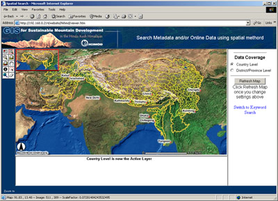
spatial search facility using standard tools of GIS
In totality, the system uses the following major software packages - Esriĺs ArcGIS 8.1, Esriĺs ArcIMS 3.1, IIS HTTP Server. XML has been the underlying database for metadata and its administration. The system is tied together through a number of XSL, ASP, JavaScript programs and various web pages.
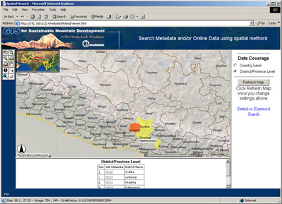
Prospective users must have access to a current web browser to the metadata server, residing on the portal. One can query the metadata, either defining an area graphically or by providing a keyword textually. While in the graphical search, a number of standard ArcIMS tools such as zoom, pan, identify are available to focus precisely on the area of interest. One of the advantages of the system is to be able to use web browser as a client to view the metadata with the same look and feel of ArcCatalog with interchangeable stylesheets on-line. The other advantage is that from the metadata, the data also can be accessed, where provided, using the standard tools of a GIS available in ArcIMS.
The system includes a Metadata Editor for capturing metadata. The editor has been developed using Visual Basic with the type for creating an ActiveX DLL. It references the Esri Object Library and contains a class that implements EsriCore.Imetadata editor. Once registering the DLL on a machine, it becomes integrated within the ArcCatalog environment. It has an easy-to-use interface that is targeted to the groups in the region who need only basic but relevant information as explained earlier. To link up with the metadata server to facilitate query and consistent presentation a special ID is also assigned inside the metadata.
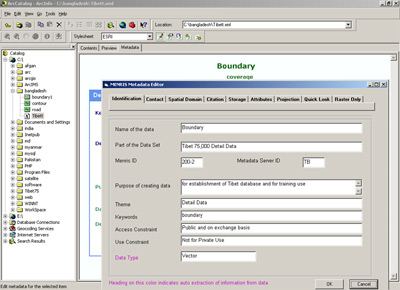
Figure 2: Customized Editor
Metadata created with the customized editor is stored as XML data in a file alongside the data. XML (extensible markup language) is a markup language similar to hypertext markup language (HTML). HTML defines both the data and how it's presented whereas XML lets you define data using tags that add meaning. Stylesheets define how XML data is presented. They are created using extended stylesheet language (XSL). XSL elements query and evaluate XML data. Stylesheet retrieves specific values from an XML document, formats them, and then defines how they are presented. To see metadata with added elements via the above editor in ArcCatalog, we have also build a new stylesheet named MENRIS stylesheet to include these elements. Therefore, you can interact with metadata as you would interact with any web page in a browser.
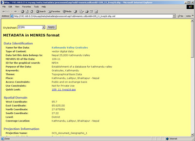
Figure 3: MENRIS Stylesheet with Interchangable Option
Because the presentation information is stored separately, you can change the metadata's appearance using different stylesheets. XML is an emerging industry standard that is being used to transfer data across the Internet. Many different applications can be used to view XML files and this capability is used by this system to make it available on the Internet. In fact, the maps, applications resources on the portal also use XML as the underlying technology.
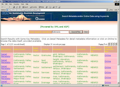
The metadata server is a web server in combination with Esriĺs ArcIMS 3.1 application and metadata as XML database. Customised interfaces for data query have been developed using ArcIMS tools. The whole metadata database is managed by a separate XML application available for the administrator. Searching for metadata is quick as users can perform searches graphically by defining their area of interest with drawing tools available within ArcIMS or make searches by providing a keyword. When searching graphically, the different datasets available in the user area of interest is presented first and then selecting a dataset takes the user to metadata.
|
|
|
|
Figure 4: Spatial Search Interface |
Figure 5: focused Area of Interest after zooming in |
Whatever may be the search option, the user can view the data title, theme, and key elements initially and choose to view the full metadata for any interested data, which also includes quick look of the data. To change the stylesheet that is currently being used to transform the metadata, simply the user can choose a different stylesheet from the dropdown list available. This way you get the look and feel of viewing the metadata as of in ArcCatalog.
|
|
|
|
Figure 6: Keyword Search with brief metadata |
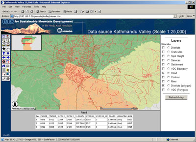
Figure 7: Accessing data from metadata via ArcIMS 3.1 |
As mentioned earlier, geographic data can be accessed by going through the metadata into the data served by ArcIMS as illustrated in Figure 6 and Figure 7. There is also the option to view directly the data on-line, hence the name Metadata/Data Server.
At minimum, a geographic information infrastructure is realized through a catalog holding metadata about available data. The main objective of metadata is to document and catalogue the existing geo-spatial database and facilitate its use for the prospective users. The task of creating metadata of these databases is a cumbersome task which requires commitment as well as resource allocation. The system designed with all the latest technology will have no meaning if information about the databases are not entered or shared in the first place.
Another important factor is that different countries of the region have different data policies and the users may not have access to many databases even when they exist with some government departments. ICIMODĺs approach has been to work through a network of partners. The willingness of the partners to share their data and their commitment to build and publish their metadata using the system will be a very important factor towards the development of a Regional Geographic Information Infrastructure.
Development of metadata serves as the basic and important component in accomplishing a Regional Geographic Information Infrastructure. ICIMOD has put into place a comprehensive metadata system using the tools of GIS itself developed mainly by Esri to document GIS databases as well as to facilitate its sharing among the national and regional institutions and researchers through the portal framework. This system when fully operational outlines creation of a common place on the Internet offering a new one-stop experience for all the geo-informatics data needs in the HKH region. ICIMOD, through close contact and collaboration especially with Esri, is committed to advancing the use and capabilities of this framework needed to facilitate the sharing of geographic information among users in this part of the world. It is not the intent of ICIMOD to create a centralized data system or repository but to facilitate and point to distributed current stores of spatial data through metadata against searches.
Its potential will be realized when all ICIMOD partners and GIS stakeholders in the region will join together to publish their metadata using the system. Such a network will make it possible for the user to know about any existing geographic information in the HKH, an important step towards realizing the vision of a Regional Geographic Information Infrastructure. Further, this can contribute to bridging the data gap in the region and aid in global data sharing initiatives such as Geography Network.Com and others.
ICIMOD: Mountain GIS Portal in the Hindu Kush-Himalayan Region, 2002, ICIMOD, Kathmandu, Nepal
Department of Science and Technology, Government of India, 2001: National Spatial Data Infrastructure (NSDI) Strategy and Action Plan. Task Force on NSDI, Dept. of Science and Technology, Govt. of India.
Shrestha, B. and Bajracharya, B.: ICIMOD's Approach Towards a Regional Geo-Information Infrastructure (RGII) in the Hindu-Kush Himlayan (HKH) Region, National Geospatial Data Infrastructure: Towards a Road Map for India, 5-6 February, 2001, New Delhi, India.
NASA: Directory Interchange Format (DIF) Formal Syntax Specification v6.0. http://gcmd.nasa.gov/software_docs/dif_syntax_spec.html
Bajracharya, B, and Pandey, S.: A metadata system for Geographic Information in the HKH, Regional Seminar on Geo-Informatics for Asian Eco-systems, 3-4 Dec. 2001, Kathmandu, Nepal
Dangermond, J.: g.net ľ A New GIS Architecture for Geographic Information Services, Spring 2001, ArcNews Online, Esri, http://www.Esri.com/news/arcnews/spring01articles/gnet.html
Bitter, P. and Shrestha B., 1999: Regional Geographic Information Infrastructure in the Hindu Kush ľ Himalayan Region, ICIMODĺs Perspective. http://www.gisdevelopment.org
Bajracharya, B.: Development of Geo-Information Infrastructure, issues in the Hindu Kush-Himalayas, Issues in Mountain Development, 2/2000, ICIMOD, Kathmandu, Nepal
Esri Profile of the Content Standard for Digital Geo-Spatial Metadata, An Esri technical paper, August 2001
Esri Manuals and Software on ArcIMS 3.1 and ArcGIS 8.1
Sushil Pandey
System Officer, MENRIS, ICIMOD
Kathmandu,Nepal
Tel:977-1-525313
Fax:977-1-524509
Birendra Bajracharya
GIS Officer, MENRIS,ICIMOD
Kathmandu,Nepal
Tel:977-1-525313
Fax:977-1-524509
Basanta Shrestha
Acting Division Head, MENRIS, ICIMOD
Kathmandu,Nepal
Tel:977-1-525316
Fax:977-1-524509