Implementing a Web-Based Document for NASA Research Center
Dana Dwyer
CONTENTS:
ABSTRACT
BACKGROUND
INTRODUCTION
METHODOLOGY
B. Map Creation
a. Contents
b. Maps
PRODUCTS
DISADVANTAGES / PROBLEMS
CONTUATION OF PROJECT / PROPOSED UPDATES/ SCOPES
ACKNOWLEDGMENTS
ANNEXES
REFERENCES
ABSTRACT
The NASA Langley Research Center is in the process of developing an entirely
web-based Master Plan application that allows the user to view and query interactive maps generated from spatial, financial, and asset data in the Oracle database. This project will integrate all tabular and spatial data to support future Center planning. Using ArcIMS, Oracle Spatial, and ArcGIS, the development procedure will be discussed including the customization needed to accomplish such an application. Solutions focus on cross-browser compatibility using the HTML viewer, integration with ArcSDE and Oracle's Application Server. Finally, the advantages of a dynamic web-based application over the static historical approach will be reviewed.
_______________________________________________________
NASA Langley Research Center
PROJECT BACKGROUND
The GIS Team developed the project for the Capital Investment Planning Office, as part of an initiative on creating an Online Facilities Master Plan (FMP). This is part of Executive order 12906, which calls for implementation of a coordinated National Spatial Data Infrastructure to support public and private sector applications of geospatial data. The LARC FMP acts as an effective information management guide for future infrastructure planning. The primary objective of the project is to catalog existing Center data and access it all using geographic information systems online.
INTRODUCTION
CIPO interfaces with NASA Headquarters on all space utilization activities and assists other LaRC organizations with strategic long range facility planning. Oracle RDBMS maintains all space utilization data along with tight coupling to the Arc/Info GIS. This system allows for extensive generation of reports and provides excellent graphical representations of every imaginable facility use.
The GIS architecture used for the FMP will provide a means to capture knowledge and display it for use by Center personnel to make informed decisions for accomplishment of our strategic blueprint objectives.
The ability to track, report, and compare Center information is enhanced with query options to more specific activities, or to roll-up information for high level situations. Reporting these results is made easily accessible and quick. Data can be obtained from one database tool and then used for analysis as needed by that same tool.
METHODOLOGY
Data
Development of the GIS portion of the project involved a multi-step process. The GIS Team's development engineers set up information in an SDE database, which technicians use in designing quality maps. The Centers data sets were collected from several sources; maintenance facilities, full cost values that support center requirements and maintenance, etc. Esri software was used as a base to meet project requirements.
Coverages existed in different formats and/or units, hence the initial processing for each of these involved decompressing, converting, and/or re-projecting the data into NAD 83 Harn.
LARC's some 300 facilities, 4000 employees, and $4 billion price tag carries a lot of information to catalog. Major data sets are formed into base map coverages and imported into GIS SDE software format. Listed are a few of the features data sets.
local and regional information
Map Creation
Center maps are organized into 12 sections of the FMP guidelines. The series are based on pre-determined categories and geographic detail of the LARC area mapped. Examples of these sections are Center Missions, Regional Data, Buildings and Structures, Transportation, Safety, Environmental, and Security.
Base map coverages consist of the same staple coverages such as roads, buildings, and parking lots. Additional layers specific to the FMP section map are then added.
ArcCatalog allows for creation of new layers and management of existing data. ArcMap was used to display these layers and edit them if needed. After these steps to correct the layers, they were then be added in ArcIMS Author.
The development stage of ArcIMS Author is the first vital step in the process of creating a new map or revising an existing one.
The technicians utilize map generalization techniques such as cartography to display data from the master SDE database. For example, wetland classifications and transportation entity classes are based on the Army Corp of Engineer's SDS/FMS Browser specifications. Buildings and roads must appear in many maps, so it is important to maintain standards.
Once the designer finished a layout, it was time to finalize the design by manually adding elements that highlighted the map�s important features. The highlights
included a selection of highway shields to indicate the main road network for a regional map or labels scaled to render at different zoom levels to prevent clutter.
Esri provided regional data on local hospitals, churches, etc. Depending on the map, additional features such as state and/or city boundaries and the coloring of main roads to highlight them would be added as well. Author's functionality enables the designer to put together a professional quality map with relative ease.
In order to achieve its objective, the design must communicate the most important features of the map. It also provides the precise map view dimensions as well as their respective scales for the users to produce the maps they desire. At this stage, individual map layers were added and their respective extent polygons that would later become part of the map extents (i.e. the West and East Area extents of Langley Research Center are set zoom factors for quick access).
NASA LARC Online FMP INTERFACE
The designer then creates map services using ArcIMS Administrator. From here, the web-page design process begins. ArcIMS Designer allows for the existing mapservices to be passed down the assembly line, through a template, and spits out a functional map.
Other pre-fabricated map elements such as the legend and layer boxes were created in the template as a special customization for the NASA LARC FMP maps. Map elements such as the tool bar options were fitted into place on the main view. Depending on what functions the provider wants to be available for the user, will dictate how many tools are present on the final website.
Approved designs were then put on the FMP website where planners could examine them and give input. Submitting revisions to the Master Plan is made easily accessible to users of the FMP. They become involved in the process by submitting comments, concerns, and criticisms. The first draft frequently underwent major revisions due to this feedback. When it came to colors of buildings, comments from the peanut gallery were usually not appreciated by the designer.
The FMP web page itself is designed for allow the user to select a map from either a table of contents or a list-of-maps page. A separate window will open when a certain map is selected. When the user is finished with the map, they can return to the original page easily.
ANALYSIS OF ONLINE FMP MAPS
DATA QUALITY
The owners of the original data sets maintain information integrity. Contractors and other NASA organizations coordinate with the GIS Team to make sure the displayed maps are 100 percent correct. The updates that they perform are continuously being refreshed. The most current tabular data is linked to the displayed points, lines, and polygons. The electronic submittal of updates maintains its accuracy. The mapservices need to be refreshed in Administrator in order for these updates to display on the web page.
SPATIAL ANALYSIS
Query capabilities of the ArcIMS program allow the user to identify points, lines, and polygons displayed. They can also search the map for a known attribute and the query function will automatically zoom to its extent. Strategic decisions can then be made from the displayed map. The user can then manipulate the map and display exactly what information they need. A print out of this map is easily obtained by using the PDF print tool on the web page.
DISVANTAGES / PROBLEMS
The GIS Team decided to make the map design and compilation process its first test for the new Esri ArcGIS/ArcIMS platform. A large amount of customization was coded specifically for the FMP web site. Maps that were in the GIS Teams ArcMap files had to be recreated in Author. This was a very time consuming process that seemed redundant. The latest version of ArcIMS didn't recognize all the code customization that the GIS Team performed on the original out-of-the-box ArcIMS. Having this in mind, and given the promise of an easier user experience, the GIS Team is working on not having to go through and rewrite the new ArcIMS.
FUTURE USES
As the FMP ArcIMS website gains more users, more feedback allows for further improvement. New maps are expanding the site and revisions will continue. Currently, suggestions call for limited selection of Zooms to optimize printing efficiency and help to keep production costs down. Together, the map type and the available paper sizes provide the framework that allows the designer to begin assembling a new map.
Buildings broken down by floor level with links to employee information are another idea. The possibilities seem endless.
CONCLUSION
Development of the online FMP for Langley demonstrates one solution for the Agency and is a pilot for other Centers to use geospatial applications in development. The revised Master Plan incorporates new content as well as links to more in depth information pages than the former paper version.
During the information acquisition stage, processed and analyzed using a global perspective, the technical data obtained pinpoints missing information and distinguishes the need to further investigation for further improvement to plans and strategies for infrastructure planning. The expansion of this tool can only lead to a more efficient system.
ACKNOWLEGDEMENTS
I would like to acknowledge my mentor, Mary Gainer, for all her guidance while working on this project. The GIS Team members: Brad Ball, Mike Golub, Berch Smithson, Robert Gage, John Meyer, Ray Gates, and Wanda Barnes were all advisors along the way.
ANNEXES
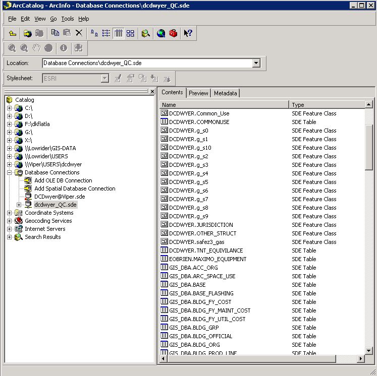
Figure 1. Existing or newly created layers are kept in ArcCatalog. Center data can easily be previewed here for later use in ArcIMS.
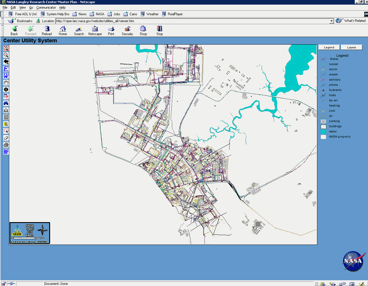
Figure 2. The online Facility Master Plan Utility Map. The customized tool bar on the left of the screen allows the user to manipulate the map. A layer and legend tab to the right explains map attributes.
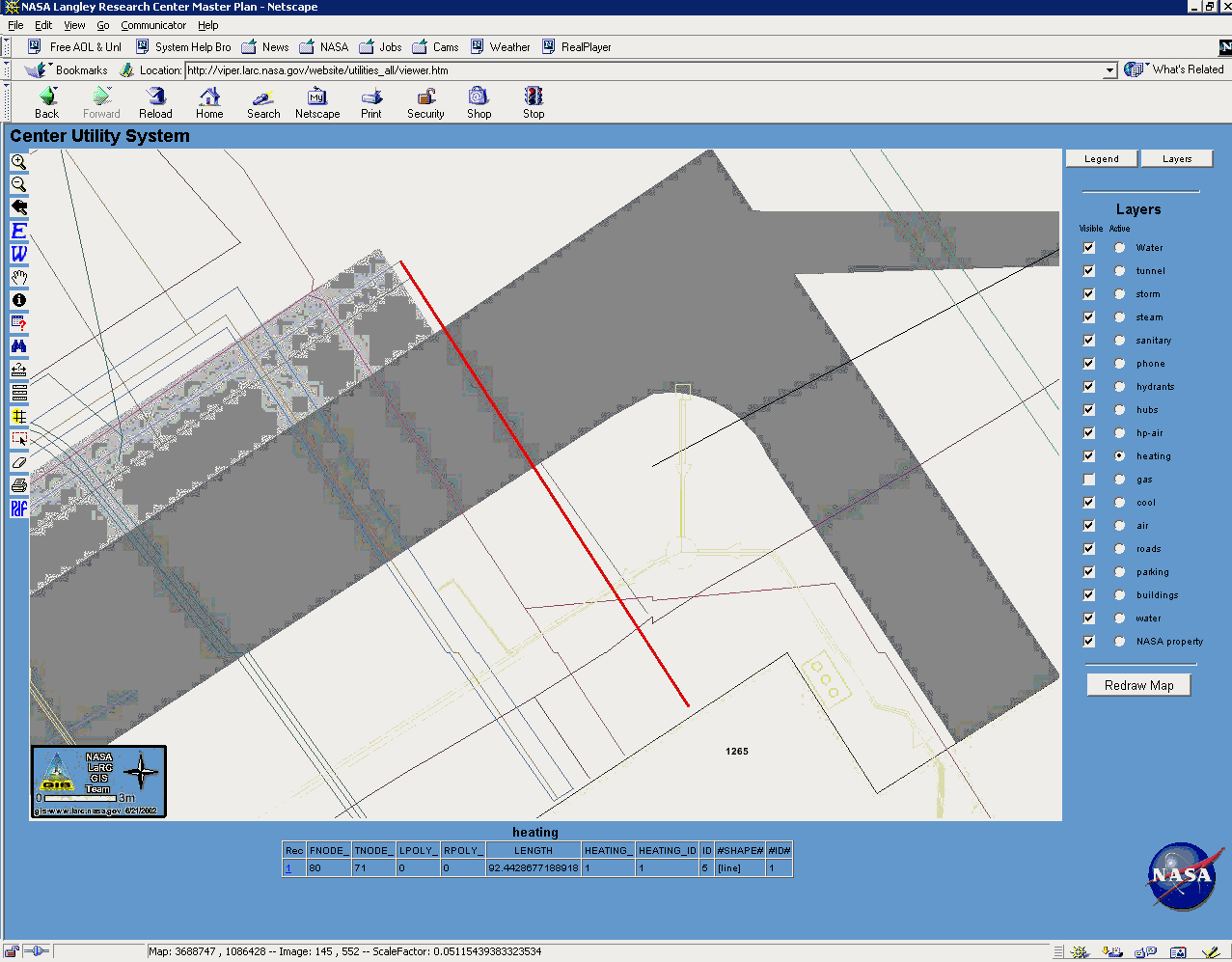
Figure 3. A query can identify a heating system pipe and it's attributes. Here, the user searched for a pipe with a specific length. The tool allows the map to zoom in and highlights the desired pipe in red.
References:
Gainer, Mary, William B. Ball, and Rodney Harris. Continuous Improvement Proposal. A Center Facilities Master Plan Management Information System. February 2002.
NASA Langley Research Center Facilities Master Plan Executive Document. 1993
NPG 8820.XX Appendix F: Master Planning
Author Information:
Dana Dwyer
NASA Langley Research Center, Mail Stop 445 Branch CIPO , Hampton, VA 23681
(Phone) 757-864-6816 (Fax) 757- 864-8463 d.c.dwyer@larc.nasa.gov