M. Murata
In the last few decades, the electric power industries in Japan have been developing power transmission systems to follow up with the rapid growth of the power demand. On the other hand, the suitable site for new transmission lines has been getting restricted, because of development of rural areas and the growing concern over environmental issues. A GIS application system was developed to support planners and engineers in the environmental and engineering analyses for transmission line siting. ArcInfo, GRID, TIN and NETWORK were implemented to perform various analyses such as the selection of suitable areas, the optimum path finding, the profile analyses, the engineering design of towers and wires, and the cost estimation. The purpose of this paper is to describe the outline of this system and the methodology of analyses performed.
A transmission line is one of essential infrastructures of the power supply system. In the site evaluation process for those facilities, it is necessary to carefully consider not only technical issues, but also the impact on natural environment, the influence on local communities, and various regulations.
However, it is getting difficult to find the preferable site for a transmission line, because of the increasing cost of constructions, the increasing concern on environmental issues and the growing consciousness of land owners. In addition, the number of experienced planners and engineers engaged in the siting process is decreasing with generational changes.
To solve those problems, a computer system has been developed employing GIS technology. The system integration project started in 1988. The feasibility studies had been made for three years to evaluate the merit of GISs in the transmission line siting. Development of applications started in 1992 and will be completed in 1995.
ArcInfo, TIN, GRID, NETWORK are used to perform various analyses on geographic database which is necessary for the site evaluation. This paper describes the outline of the system, and mentions technical topics on methodologies.
In general, the process of the planning and design of transmission lines consists of the following 5 phases.
The computer system developed here supports phase 1 to 4, and consists of 5 subsystems. FIGURE 2.1 shows the outline of the system.
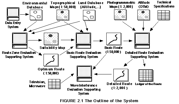
The function of each subsystem is described as follows.
This subsystem is to install, check and edit the geographical database used in all subsystems. The database includes the following.
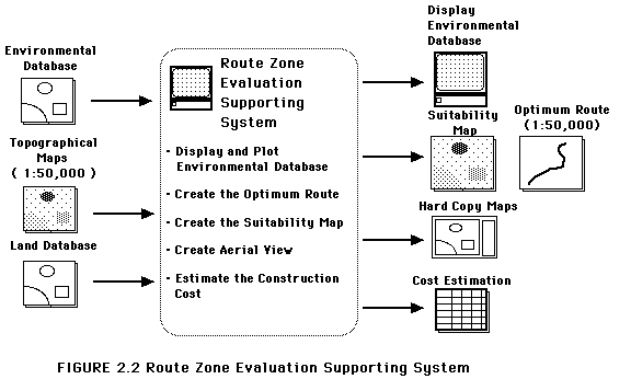
The purpose of this subsystem is to select the zone, called the "route zone", which is considered suitable for a transmission line in terms of environmental impact and regulations. The route zone is determined in the scale of 1:50,000. The functions of this system are described in FIGURE 2.2.
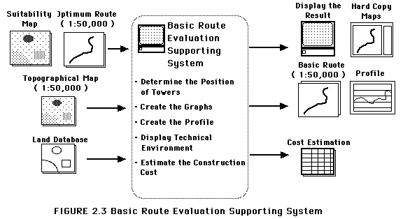
The position of each tower is determined interactively referencing the topographical maps, the suitability maps and the optimum route computed above. The system has the following functions. (FIGURE 2.3)
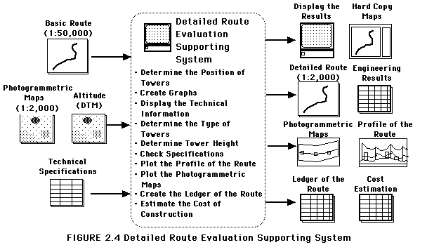
Once the basic route is determined, the photogrammetric surveying is performed along the route to make planimetric and topographic maps, and DTMs in the scale of 1:2,000. Based on the database, the detailed position of each tower is determined in the scale of 1:2,000. Furthermore, the system has various functions to perform the engineering analyses. FIGURE 2.4 shows the functions of this subsystem.
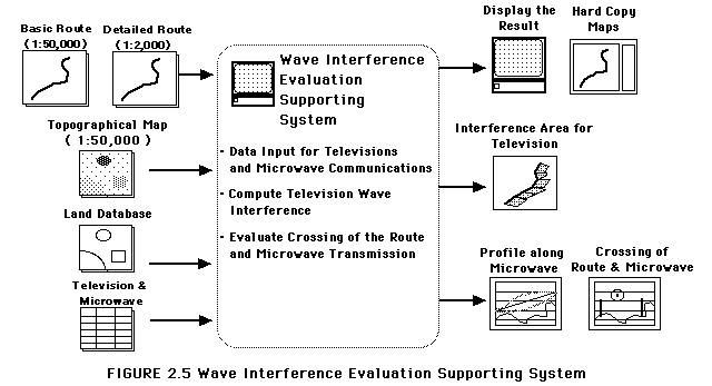
A transmission line may cause the interference in television and microwave communication. The purpose of this subsystem is to predict the wave interference caused by the determined transmission line. The system has functions as shown in FIGURE 2.5.
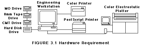
The hardware requirement of the system is described in FIGURE 3.1.
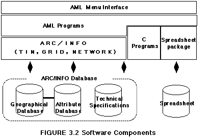
ArcInfo, TIN, GRID and NETWORK are implemented in this system. In addition, a spreadsheet package is employed to perform the cost estimation. For engineering computations, original programs are coded using C language.
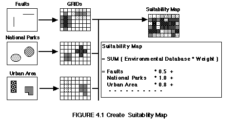
The existing process of the site evaluation was reviewed for this project. As the result, the environmental information was classified into three categories, natural, social and technical environment. Each of those categories contains such layers as follows.
An index is introduced to represent the relative difficulty of the route construction, which had been determined by experienced engineers before. The index is defined as described below.
The index number is assigned to each polygon feature of the environmental database, according to the difficulty of route construction. For point or line features, a sort of buffer procedure is performed using GRID function, and the index number is assigned according to the distance from the center.
The suitability map is created by overlaying and summing up all indexed layers. This procedure also utilizes GRID functions, and is shown in FIGURE 4.1.
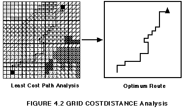
The resulted suitability map is considered to represent a sort of impedance for route construction. Using GRID COSTDISTANCE functions, the optimum route is computed based on the suitability map as shown in FIGURE 4.2.
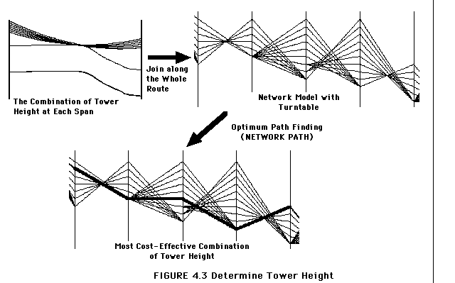
In the detailed route, height of each tower is determined to minimize the cost of construction of the whole route. It is accomplished as shown in FIGURE 4.3.
First, the possible combination of tower height is computed for each span. The required clearance of wire should be ensured over the ground and structures.
Then, the combinations of tower height are joined along the whole route. The result is constructed as a network model with a turntable. The cost of each turn is computed, which depends on the tower height and the tower type.
Finally, the optimum path is derived using NETWORK PATH command, based on the cost at each turn. The resulted path corresponds to the most cost-effective tower height combination.
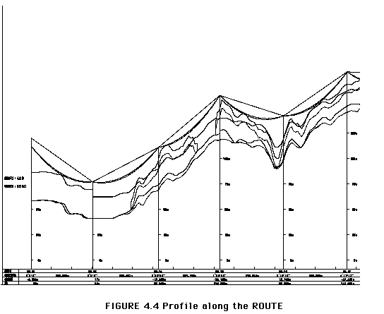
Once the detailed route is determined, the profile along the route is plotted as one of the final results. This plot includes the profile along the route, the structures under wires, the required clearance, the dip of wires, and the towers. FIGURE 4.4 shows an example of the profile plot. Those features are plotted using GRAPH commands in ARCPLOT. The curves of structures, clearance and wire dip are computed by original programs coded with C language.
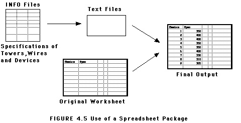
The cost estimation is accomplished using a spreadsheet package. The specifications of towers and wires, which are stored in INFO files, are converted to text files to be read by the spreadsheet, as shown in FIGURE 4.5. Use of existing packages makes it easy to create a ledger of the route or to estimate the construction cost.
A GIS-based application has been developed for transmission line siting. This system supports from the planning phase to the engineering design phase and provides total solution for the siting process.
ArcInfo is employed as a powerful toolbox in this system to perform complex analyses based on geographic database. Furthermore, the combination with other applications, such as a spreadsheet package and original programs coded with C language, makes it possible to support various phases of transmission line siting.
Several extension of the system are planned in the next phase of this project. The extensions include the automatic siting of each tower, the use of the result of detailed filed surveying and the simulation of realistic views using CAD packages.
I deeply appreciate Tohoku Electric Power Corporation and Tohoku Computer Service Co.,Ltd, who provided the opportunity to present this paper. Also, I would like to appreciate the generous assistance of my colleagues.