David Henry and Even Husby
Wilderness Quality is in this project defined as the extent to which the nature is changed or disturbed due to influence from modern society. This project has attempted to assess wilderness quality in the Barents Region by applying methodology developed by the Australian Heritage Commission.
Wilderness Quality is assessed in terms of remoteness and naturalness. The concept is based on the fact that it is possible to have a continuum of values across the landscape ranging from urban to pristine. Ideally four separate indicators are measured. Three indicators have been measured to date; remoteness from settlement, remoteness from access and apparent naturalness. The fourth indicator, biophysical naturalness, has yet to be measured, but will form part of a future data acquisition exercise. A wilderness quality index has been calculated by the addition of standardised class values for the three measured indicators. Maps have been produced which show wilderness quality and each indicator measured.
The potential of using the wilderness quality assessment in a management context has been examined through the analysis of protected areas in relation to the apparent naturalness indicator. Other aspects addressed include; data issues; other potential applications; and suggestions for the future direction of this pilot project.
Disclaimer: The views presented in this document are of the authors, and does not necessarily represents the view of DN, UNEP/GRID or NRSC.
The goals of the project are:
The target audience of a wilderness quality map are planners and managers working within the Barents Region. The methodology is also developed as a general framework for such work within the Arctic region and globally.
Wilderness is a priority issue in international environmental management. The Convention on Biological Diversity, mentions Wilderness as a priority item. "Each party shall ... identify components of biological diversity important for it's habitats ... containing high diversity, large number of endemic or threatened species or wilderness." (Convention on Biological Diversity, 1992).
Wilderness quality is defined in this project as the extent to which the nature is changed or disturbed due to the influence from modern society. This definition is based on a purist's understanding of what "wilderness" means. Wilderness can, based on this, be expressed in terms of two key components, - remoteness and naturalness. I.e. an areas degree of remoteness from human activities, and an areas degree of modification from a natural state due to human impact through cultivation, pollution, development, etc.
The project is being developed as a joint activity between GRID-Arendal, The Norwegian Directorate for Nature Management (DN), and the National Remote Sensing Centre (NRSC). The initiative was based on DN's interest in an assessment of wilderness in the Barents Region, and GRID-Arendal's general ambition regarding assessment of Arctic environmental conditions. NRSC's interests lie in developing environmental management systems through the application of GIS and have provided a generous contribution to the project in terms of manpower and other resources.
There are several initiatives underway focusing on the issue of wilderness status or wilderness reduction. The most comprehensive one is perhaps the Australian Heritage Commission's (AHC) National Wilderness Inventory. This inventory was initiated by AHC in 1986 "as a result of community concern over the rapid decline in area and quality of relatively remote and natural land in Australia" (Lesslie et.al, 1993). The inventory is seen as the first step in a process to develop strategies for wilderness conservation.
The methodology applied is described by R.G. Lesslie et. al. (Lesslie et.al., 1993). Wilderness is defined as "the extent to which land is remote from, and undisturbed by, the influence of modern technological society". AHC derives a wilderness quality index based on the evaluation and integration of the following four components:
The methodological framework used by AHC is also the one which forms the basis for the Barents Region study.
One of the first broad attempts towards a wilderness assessment of Norway was in relation to an Official Report to the Parliament (NOU) from the State Nature Conservation Council (Statens Naturvernråd) regarding a country-wide plan for national parks and nature parks (NOU, 1986). Three maps were presented, showing "wilderness" (urørt natur; pristine/unmodified) areas for the years 1900, 1940 and 1980. This has later been extended by GRID-Arendal in co-operation with the Norwegian Mapping Authorities to include the year 1992 (Report to the Parliament, nr. 62, 1991-1992). These maps, when shown together, give a dramatic picture of how the wilderness has been reducing throughout the century. The criteria for choosing "wilderness" areas is: all areas with a distance of 5 km or more from the closest road, railroad, populated place, hydropower development site or power lines.
The national wilderness mapping gave a national overview, but more detailed information is required in order to utilise wilderness maps as a management tool. A new project has been initiated by the Directorate for Nature Management in order to do similar, but more detailed studies at the county level. This activity is underway at the Norwegian State Mapping Authorities Aust-Agder office, and they expect to present the maps during spring 1995. The methodology will be similar to the national survey, but include several types of encroachment. The analysis uses different distances in order to establish a more representative picture.
An evaluation of world wilderness areas has been compiled by the Sierra Club and the Centre for Earth Resource Analysis of the World Bank. The compilation process used the Jet Navigation Charts (scale 1:2,000,000) of the US Defense Mapping Agency as a primary data source. The inventory was undertaken to provide an answer to the question "how much of the land surface of this planet still is predominantly influenced by the forces of nature" (McCloskey, 1989). The methodology was to analyse Navigation Charts in order to identify areas showing no development. The development status was identified by the presence of roads, settlements, buildings, airports, railroads, pipelines, powerlines, canals, causeways, aqueducts, major mines, dams and reservoirs, and oil wells. The primary source maps are used for commercial and military aeronautical navigation, and show more detail with respect to human made structures in sparsely settled areas. Only blocks of more than 400,000 hectares were identified.
This project has not attempted to define what a wilderness area constitutes. To attempt this would be at best contentious and at worst impossible.
Recent research carried out in New Zealand (Kliskey and Kearsley, 1993) has recognised that the concept of wilderness lies in different peoples perceptions. "... while the environments in which wilderness might be found have an objective ecological reality ... what makes the reality explicitly 'wilderness' rests very much with the individual, and her or his personal cognition, emotions, values and experiences." (Kliskey and Kearsley 1993, Stankey and Schreyer 1987).
Wilderness was assessed for a national park area in the north of South Island, New Zealand. The work looked at measuring four properties; artifactualism (absence of human impact), remoteness, naturalness (aspects of forest and vegetation) and solitude; across four backcountry user groups (as previously identified by Stankey (Stankey 1973)). These groups cover a range from non-purist to strong purist. By looking at four different user groups differing perceptions of wilderness can be considered.
The work carried out in this project acknowledges the importance of perception in defining wilderness. However, the objective of this project was to produce factually measured indicators which can then be interpreted in the most appropriate way by whoever uses them. Perceptions may then affect the use of this product.
The study area for this project, the Euro-Arctic Barents Region, encompasses the counties of Nordland, Troms and Finnmark in Norway, Norrbotten in Sweden, Lappland in Finland, Murmansk and Arkangelsk Oblasts in Russia and the Republic of Karelen.
Wilderness quality is assessed in terms of remoteness and naturalness. The concept is based on the fact that it is possible to have a continuum of values across the landscape ranging from urban to pristine. The methodology adopted requires that four separate indicators be measured; two for remoteness and two for naturalness. Three indicators have been measured to date; remoteness from settlement, remoteness from access and apparent naturalness. The fourth indicator, biophysical naturalness has yet to be measured, but will form a part of a future data acquisition exercise.
The sections below describe the results of each indicator measured. Maps have been produced for each indicator and for an overall wilderness quality index.
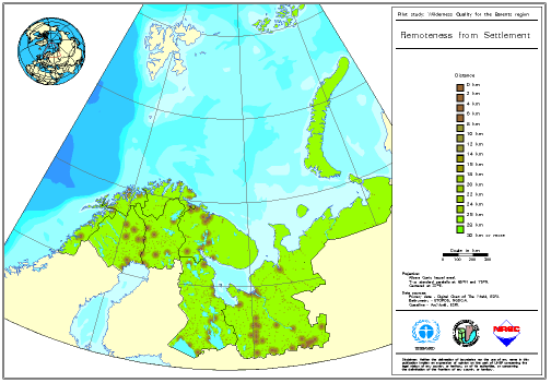
The remoteness from settlement map, Figure 1, shows the influence of areas of permanent human habitation on wilderness quality. The scale on the map represents distance from settlement features. These features constitute major urban areas through to small hamlets and groups of holiday huts. Within the primary data it has been apparent that there is an element of inconsistency in the grading of populated places. However, in general, when viewed at scales in excess of 1:3 million this data is sufficiently accurate to obtain a regional picture. If management decisions are to be made at a larger scale then it is appreciated that more accurate data is required.
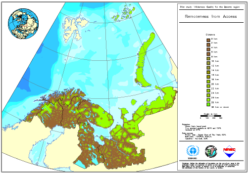
The remoteness from access map, Figure 2, shows the influence of established access routes on wilderness quality in terms of distances measured from such features. Access features include roads, rail lines, tracks and airports. Access features are weighted depending on their perceived level of importance. The effects on reducing wilderness quality are more pronounced by this indicator when compared with remoteness from settlement.
The reduction in wilderness by the apparent naturalness indicator can be seen in Figure 3. This figure shows distance from structures associated with modern technological society. Features in this indicator include pipelines, telegraph poles, power stations, together with all access and settlement features.
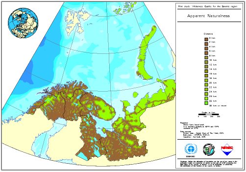
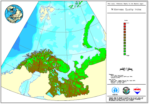
Figure 4 shows a wilderness quality index calculated for the whole study area. This index is calculated by the addition of standardised class values for the three measured indicators. This map does not show measured distances in the same way as Figures 1 to 3. For this reason it is not directly comparable with the previous maps.
A more accurate indication of wilderness quality would be achieved if a biophysical naturalness indicator could be incorporated into the index. Ideally this could include biophysical effects important to the Barents Region; such as vegetation stress due to over-grazing, effects of timber harvesting and the damage caused by pollution.
A few areas appear to retain a significant level of wilderness. These include the inner regions of the Kola Peninsula, Novaya Zemla and the western regions of Archangelsk Oblast. An area of north west Sweden also stands out as free from the influence of access routes. Within this area lies the Abisko and Vadvetjakko national parks.
The potential applications for this product are many. The ability to catalogue wilderness areas will help to meet the requirements of Agenda 21 (United Nations Conference on Environment and Development, Rio de Janeiro, 1992). This could then be useful in helping to identify areas of important biodiversity that may require protected status.
The Barents Region has been identified as a region that can support increased economic activity, particularly across national borders. Protection of the environment in the context of such economic activities will be paramount. The monitoring of temporal effects on the areas of high wilderness quality will be possible using the methodology developed.
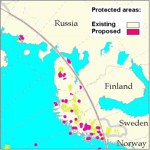
To demonstrate how the wilderness quality assessment data can be used in a management context the apparent nauralness indicator has been compared to areas receiving protected status within the Barents Region. A map showing the location of protected areas can be seen in Figure 5.
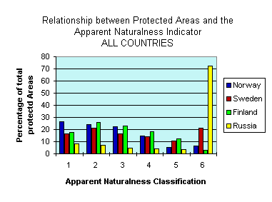
To undertake this analysis the apparent naturalness indicator has been reclassified from a 0 to 30 km continuous distance data set into a equally spaced six category classification, with 1 representing the lowest distance (0 to 5 km) and 6 the greatest (25 km and over).
The protected areas data encompasses only land based areas as presented in "The state of Protected Areas in the Circumpolar Arctic 1994" (CAFF, 1994). These areas were available per country which has enabled some comparison to be made between nations. It must be emphasised that the analysis undertaken reflects the resolution and quality of the primary data. The results give only broad indications and it is recognised that the distance away from structures associated with modern technological society (apparent naturalness) does not fully define or give reason to designate an area "protected".
Looking at all land based protected areas some national variations can be seen for average apparent naturalness indicator values. Protected areas within Norway (2.7), Sweden (3.4) and Finland (2.9) have similar average apparent naturalness values, whereas Russia (5.0) has a much higher average value. For Sweden the percentage spread across the apparent naturalness categories is fairly even, while Norway and Finland both diminish as the category increases. Russia shows a fairly even and low spread across categories one to five with a significantly large proportion in category six (72%). This high value is probably caused by the status of Franz Josef Land as a protected area together with other large areas on the Kola peninsular. Large average indicator values could be caused by the general size of a particular countries protected areas. This in turn might be reflective of the policy determining which areas receive protected area status.
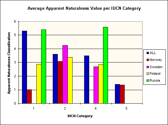
The World Conservation Union (IUCN) categorisation (as of 1993) for protected areas has also been compared to the areas apparent naturalness classification. Figure 7 below shows the average apparent naturalness value for each IUCN category. This can be seen for the region as a whole and for each individual country. It should be noted that not all protected areas in this region have an IUCN categorisation. IUCN categories I, II, IV and V are present in this region. A category I area is a strict nature or scientific reserve; category II is a national park; category IV is a managed nature reserve or wildlife sanctuary and category V is a protected landscape.
Not one country has protected areas in each of the four IUCN categories. There are no striking results from this analysis except to note the high apparent naturalness values seen in Russian IUCN grade's I and IV. Category II, national parks, shows similar apparent naturalness values for Norway, Sweden and Finland. For each of the Scandinavian countries the highest average apparent naturalness values can be found in IUCN category II. This may show similar ideas as to what constitutes a national park?
It should be emphasised once more that the results obtained, not just from this statistical analysis, but from the overall wilderness quality assessment, must be viewed as a demonstration of a methodology. This work was undertaken as a pilot project using low resolution primary data. Any omissions in the primary data set will have knock on effects in the results of the wilderness quality assessment and any subsequent statistical analysis.
A significant known omission is that of the biophysical naturalness layer. If available, this could paint an entirely different picture with the effects of pollution, logging and grazing incorporated. It was for this reason that it was decided to carry out a comparison using the apparent naturalness indicator rather than the wilderness quality index.
The ability to combine the wilderness quality assessment with other relevant data sets is just one way in which this methodology can be used in a management context. If the resolution of the primary data allowed, it would be advantageous to examine an individual countries protected areas or even a single area in more detail. At this level it would be possible to address, for example, how the effects of building a new dam or closing a road modifies the overall wilderness quality.
The methodology adopted for the Euro-Arctic Barents Region has been based on similar work carried out by the Australian Heritage Commission (AHC) for assessing wilderness quality in Australia. This work has attempted to replicate the AHC methodology as closely as possible given the data available and the geographic conditions relevant to this region.
A sites wilderness quality is assessed in two ways, by it's remoteness and it's naturalness. To achieve this four separate and distinct indicators are calculated. These are as follows:
Three of the four indicators were developed with biophysical naturalness being the exception. Primary data was not available for this indicator although potential data sources have been identified for future collection.
For each of the three indicators a distance was calculated to the nearest feature of interest for each grid point in a lattice of points equally spaced across the study area. Weightings were then applied to features depending on their level of significance. Grades, descriptions and weightings are tabled for each indicator in the sections below. A single distance measurement can then be attributed to each grid point for each indicator.
The primary data used throughout this project was obtained from "The Digital Chart of the World" (DCW), first edition (Esri, 1992). All primary data is from DCW unless otherwise stated. Relevant issues concerning this data source are discussed later in this paper.
Remoteness from settlement shows how remote a site is from places of permanent human habitation. It is calculated as a distance from each grid point to the nearest settlement feature. This measurement does not take into account potential obstructions such as those created by relief or water features. These effects could be modeled if suitable data were available. Four grades of permanent habitation have been defined although no data was available for the "Intermediate" level. The four grade structure has been retained to allow comparison with work carried out by AHC. Also this allows data to be included if future data sources can be identified and acquired. The following DCW database layers were used; PPPOLY, PPPPOINT and CLPOINT.
Remoteness from access shows how remote a site is from established access routes. It is calculated as a distance from each grid point to the nearest access feature. Four grades of access are defined according to the level of access they provide. Access features were graded on their perceived level of importance based on information supplied with the DCW data set. No information was available to assess the frequency of use for each class of access feature. The following DCW database layers were used; RDLINE, RRLINE, AEPOINT and LCPOLY.
Apparent naturalness considers the degree to which a site is free from permanent structures associated with modern technological society. Three grades of structures are defined according to their scale and prominence. Included within this indicator are linear features such as pipelines, telegraph poles and aerial cableways and point features such as quarries, dams, mines and power stations. Also included in this layer are access and settlement features from the first two indicators. The following DCW database layers were used; UTLINE, CLLINE, TSLINE, CLPOINT, DNPOINT, LCPOINT, RDLINE, RRLINE, AEPOINT, LCPOLY, PPPOLY and PPPOINT.
A sites biophysical naturalness is the degree to which it is free from biophysical disturbances caused by the influence of modern technological society. This indicator is not a distance measurement to a feature but rather a consideration of the intensity of influence at any given point. The intensity is measured on a predetermined scale between 5 and 1, where 5 is no influence an 1 is the highest level of influence. In the work carried out by AHC the intensity of two major influences on land use were considered; grazing of stock and timber harvesting.
In a Barents Region context decisions need to be made to determine what are the important biophysical influences. Initial thoughts suggest that, although the Australian and Barents environments are dissimilar in many ways, the important biophysical disturbances are the same. Grazing is particularly important in Northern Scandinavia. Timber harvesting is also a major industry, across large areas of the southern part of the region. Probably the most important influence for parts of this region are the effects of pollution. Various forms of pollution need to be considered; air pollution such as the effects of acid rain; oil spills on land and sea; and the effects of nuclear and chemical waste disposal (legal and illegal).
The project to date has not acquired data for this indicator. Several potential data sources have been identified and will in time be incorporated into the database.
It is the view of the authors that experts from within the region should assist the process of deciding what affects wilderness quality. In this process it would be unrealistic to incorporate influences which are too localised. Specific issues which relate to only a small area of the region could be added into the equation when making specific management decisions and would not form part of the core database.
The wilderness quality index is a simple combination of the three indicators measured to date; remoteness from settlement, remoteness from access and apparent naturalness. The three indicators are converted from distance measurements to class values to make them comparable with the biophysical naturalness indicator. The class values are then added to produce a wilderness quality estimate.
The indicators measured and the overall wilderness quality index have value in the management of wilderness at a national and regional level. However, it would be beneficial to base the assessment on primary data of a higher resolution. Layered digital topographical mapping at scale of 1:250,000 would be ideal to improve accuracy and resolution.
New data sources are required to assist in the production of a biophysical naturalness indicator for the Barents Region. Initially data is required at a scale of approximately 1:1 million. At the present moment in time it is perceived that the types of information required would cover the effects of grazing, logging and pollution. Other data sources would be pursued if the need to include them was identified.
When determining what should be included and what should be left out, it is better to leave out primary data if the effects on wilderness quality are not known. It is possible to remove areas of wilderness at a latter date if the inclusion of a data set is necessary. On the other hand if it is decided that a data set is invalid it is far harder to remove it.
The primary data source applied in this project is the Digital Chart of the World (DCW). It is a digital cartographic database based on the Operational Navigational Chart series (ONC), scale 1:1,000,000, in general, and the Jet Navigation Charts (JNC), scale 1:3,000,000. DCW represents one of the most comprehensive global digital cartographic databases available.
GRID-Arendal is currently working together with the Agricultural University of Norway (NLH) on a quality assessment of the DCW. The results from this will be presented in 1995. The Wilderness project has not initiated a detailed study of DCW quality issues, but will await the results from this study. Even so it is evident that the interpreter of results should bear some points in mind.
DCW was derived from flight charts made for the purpose of aerial navigation. Undocumented statements indicate that the positional accuracy may vary considerably. A rough estimate, by visually comparing a 1:250.000 road map for Finnmark county with the DCW road layer, indicated errors of approximately 2 km in some areas.
The completeness of layers within the DCW is questionable. The road network present in DCW was not in total agreement with the 1:250,000 road map of Finnmark. Part of the reason for this is the lack of update on the ONC map sheets of interest. Some date back to the end of the 1960's.
The general conclusion made in the wilderness assessment project is that the DCW gives a reasonably complete picture of the region as a whole, and it is also currently the best data set available which covers the region. Better data are needed if an assessment at a higher scale is required, e.g. for a single county.
A problem with an assessment like this is to be general and at the same time be useful and representative within different regions. This project has focused on a limited set of general wilderness quality indicators, which eventually could be compared on a larger regional or global basis. Each of these are underpinned by different general themes of spatial data. Additional layers of information representing variables of particular importance for one region could be included in order to strengthen the assessment.
It is evident that more accurate data are needed in order to improve the assessment. In particularly this is important for the biophysical naturalness indicator. There are several projects currently underway which attempt to identify both new and old data in a form which can be useful for this project. The joint Arctic database activities of World Conservation Monitoring Centre and GRID-Arendal are examples of such. The Arctic Monitoring and Assessment Programme (AMAP) and Conservation of Arctic Flora and Fauna (CAFF) within the Arctic Protection Strategy will also become important sources of relevant data.
Remote sensing may potentially be an important data source within such a project. A pilot study assessing the usefulness, technically and economically, of remote sensing for wilderness assessment, is underway at GRID-Arendal. This project will deliver a report by end of August, 1995.
This section will provide brief details of how the methodology has been implemented using a geographical information system (GIS). The primary data structure will be explained, the analysis process described and the steps undertaken to enable the results to be visualised will be detailed. The GIS software used was ArcInfo v.6.1.1 running on a Sun workstation.
An ArcInfo map library was created to cover an area between 55°N and 85°N latitude and between 0° and 75°W longitude. This area was divided into 15 map tiles, each 15° longitude by 10° latitude in size. The map library tile structure was projected from its defined projection of geographic into an Albers Conic Equal Area projection.
The primary data was extracted from DCW in 5° by 5° tiles and appended so that one coverage existed for each layer feature type. Each data set was then projected from geographic into an Albers Conic Equal Area projection. The primary data sets were then inserted into the map library.
Analysis is undertaken for a single map tile at a time. All of the primary data associated with that tile is extracted from the library. A lattice of grid points is then created to cover the tile area. From each grid point distances are measured to the nearest features of interest for each primary data layer using the ArcInfo "NEAR" command. The wilderness indicators are then calculated using INFO database programs. These programmes compare weighted distances measured from all the relevant layers to determine the nearest feature of influence. The associated database file for the final lattice of grid points contains, for every grid point, least measured distances for each indicator.
To enable the results of the analysis to be visualised raster grids were created for each tile. One grid for each indicator was generated using the relevant value from the lattice of grid points. Grids for a single indicator were then merged to create a single grid for the whole study area.
The significance of maintaining undisturbed, pristine areas has been identified as a central issue by both national authorities and within international nature management and conservation fora. The general approach for wilderness assessment applied in this study could, in a relatively straight forward way, be adapted to different regional settings. The main data source used in this project, the DCW, can be applied for different areas of the globe. Even so, better data are needed in order to make assessments at a more local scale.
The following are potential priority areas for future work regarding wilderness quality assessment.
When considering the future direction of this work, technological improvements should be identified and explored in an effort to improve the product. A number of improvements have been identified and could be explored if the project continues. These are listed below.
These improvements, and any others requested, would be initial goals of any future work carried out.
The aim of the project was to develop a methodology for assessing wilderness quality in the Euro-Arctic Barents Region. This aim has been achieved with the adaptation of a proven methodology developed by the Australian Heritage Commission for similar work carried out in Australia.
The database has been created and includes primary data that has been analysed to produce three indicators of wilderness quality; remoteness from settlement, remoteness from access, and apparent naturalness. Maps of these indicators have been created and are presented here. Data requirements for a biophysical naturalness indicator have been identified and data is currently being acquired under the auspices of a separate GRID-Arendal project. The results will be incorporated into the analysis when available.
The desired use of this product is two-fold. Firstly the results exist to enable the assessment of wilderness quality in the Barents Region. Secondly the database, and the maps produced from it, can be used to influence environmental decision making processes within the region. Perhaps more importantly, it can be used to motivate decisions where the need to protect, or even recreate, pristine areas is the prime issue.
Some simple statistical analysis has been carried out to compare protected areas in the region with the results from the apparent nauralness indicator. In this example it can appreciated how such results cold influence decisions, or provoke further enquiry, at a regional level.
It is important to be aware of the quality and resolution of the data used in any spatial analysis. Maps derived from such analysis should be used carefully and with regard to the scale that they were developed for. In the context of this work the database and maps are intended for use in a regional context, at scales of 1:1,000,000 and smaller. It would be desirable to use primary data at a larger scale, say 1:250,000, to enable wilderness quality to be assessed in a more local context.
Maps, such as those produced for this project, can become powerful tools for presenting ideas or arguments. The effects of human influence on wilderness quality can be assessed from the maps produced for this project. Future aims of this project would include the following; to see the output used for positive environmental management; to have the opportunity to use the methodology to assess the Barents Region in more detail with greater resolution data; and to cast the net wider and analyse new areas of the globe.
Lesslie R. & Taylor D. & Maslen M. 1993. National Wilderness Inventory, Handbook of Principles, procedures and Usage. Australian Heritage Commission.
Kliskey A. & Kearsley G. 1993. Mapping multiple perceptions of wilderness in southern New Zealand. Applied Geography 13: 203-223.
McCloskey, J.M., H. Spalding 1989. A reconnaissance level inventory of the amount of wilderness remaining in the world. Ambio, 18(4), pp 221-227.
Norges Offentlige Utredninger, 1986:13
Stankey G. 1973. Visitor perception of wilderness recreation carrying capacity. Ogden, UT: USDA Forest Service, Research Paper INT-142.
Stankey G. & Schreyer R. 1987. Attitudes toward wilderness and factors affecting visitor behavior: a state-of-knowledge review. National Wilderness Conference: 246-293. Ogden, UT: USDA Forest Service, General Technical Report INT-220.
Report from the Norwegian Parliament, 1992:62
Directorate of Nature Management 1994. Conservation of Arctic Flora and Fauna (CAFF). The State of Protected Areas in the Circumpolar Arctic 1994. Caff Habitat Conservation Report No. 1.