Abstract.
Indoor radon hazards in Nevada have been investigated by the staff of the Nevada Bureau of Mines and Geology in conjunction with the Nevada Division of Health under grants from the U.S. Environmental Protection Agency. Using the GIS software ArcInfo, a potential indoor radon hazard map of Nevada was generated by combining data sets consisting of indoor radon measurements, geology, soils, and aerial radiometric gamma-ray surveys. Analyzing these data with GIS techniques, three indoor radon hazard zones were defined for Nevada: a High zone, an Intermediate zone, and a Low zone. The High zone comprises 19% of the area of the state, the Intermediate zone 71% of the state, and the Low zone 10%. The procedures used in data capture and creation of the potential indoor radon hazard zones are presented.
Radon in Nevada has been studied by the Nevada Bureau of Mines and Geology (NBMG) in conjunction with the Nevada Division of Health (NDOH) under grants from the U.S. Environmental Protection Agency (EPA). A part of this study has been the use of geographical information system (GIS) technology in the analysis of radon data and the characterization of radon hazards. This report presents procedures used in the capture and analysis of radon data for the state of Nevada, and the creation of an indoor radon hazard map of the state. A more complete version of this report is contained in NBMG Special Publication 17 (Christensen, 1995).
The major software package used in the Nevada study was ArcInfo, produced by Environmental Systems Research Institute, Inc., (Esri). For this project, ArcInfo Versions 5.0.1 through 6.1.1 were run on a Sun workstation network consisting of a SPARC Station 2 server and two SPARC Station IPC terminals. In addition, three PC DOS compatible microcomputers running PC ARC/INFO revisions 3.3 and 3.4D were used for digitizing, editing, and preliminary analysis of data. Manual digitizing was done on one Calcomp 9100 and two CalComp 9500 series digitizing tablets. Hard copy plots were produced using a Hewlett-Packard HP-7585B pen plotter and an Encad Novajet II inkjet plotter. Other software used in the manipulation of data include the spreadsheet Lotus 1-2-3 and PC-File, a database manager.
A major part of a GIS is the acquisition and conversion of data into coverages. Many times, how the data are to be used in the analysis is not apparent until after the coverages have been created and the limitations determined. The accuracy of the data is one of the factors that determines usability. Every map has inherent error that can compound in the conversion to digital format. Errors can be introduced from the map projection, drafting errors, instability of the media, and the digitizing methodology. For the Nevada radon project many sources and scales of data were converted to digital format, each with its own accuracy limitations. The major use of GIS was to create a radon potential hazard map for the state. With this in mind all data were collected with the intent of analysis at a scale of 1:500,000. This matches the base data layers. Later the publication scale was changed to 1:1,000,000, but the ability to recreate the data at an accuracy level of 1:500,000 was maintained.
The data used in developing the Nevada radon project GIS coverages were acquired from three sources: data previously published, unpublished data developed by other agencies, and the results of NBMG studies. Descriptions of the coverages used and the methods of creation follow.
In order for thematic coverages to be useful, base data layers used for reference purposes must be compiled. The first coverage created for the Nevada study was location tics. The statewide tic coverage was based on 30 by 60 minute quadrangles. Tics were spaced at one degree longitude and 0.5 degree latitude, generating a coverage of 93 tics in the state of Nevada. This coverage can be converted, using the project command, (all ArcInfo commands are in bold print or underlined depending upon the reader used) from geographic coordinates to any one of the map projection coordinate systems supported by ArcInfo. The most common projections used for statewide coverages of Nevada are Universal Transverse Mercator (UTM) zone 11, and Lambert Conformal.
State and county boundaries were digitized from the U.S. Geological Survey (1984) 1:500,000-scale topographic map of Nevada printed on scale-stable mylar. This coverage and all others that were digitized in-house were created in digitizer units with the same tic numbering system as the projected tic coverages. After editing, the coverage was converted into the map projection of the published map using the transform command and the proper projected tic coverage. For the state and county boundaries the projection is Lambert Conformal.
The digital road network used in the study was the U.S. Census Bureau Topologically Integrated Geographic Encoding and Referencing (TIGER) data format. TIGER was created to support census programs and surveys. It consists of geographic and political data such as hydrography, roads, voting districts, and census tracts developed at the county level. Roads, streams, and other water bodies were digitized from the U.S. Geological Survey (USGS) 1:100,000-scale topographic maps of the 30 by 60 minute quadrangles. The accuracy of the TIGER coverages is no greater than the standards for the original data (U.S. Bureau of Census, 1990a, 1990b).
Indoor radon coverages were created from the results of three surveys conducted by NBMG (Rigby and others, 1994): the NBMG screening survey of 1989, the joint EPA/NDOH/NBMG survey of 1990-91, and the NBMG/NDOH targeted community survey of 1992. In each survey, short-term (two to seven day) charcoal canister radon detectors were sent to homeowners throughout the state. Each home tested was assigned a unique house code for identification. Some homes received more than one canister to test the variation of radon in the basement, ground floor, or other levels of the home. In the EPA/NDOH/NBMG 1990-91 survey, 200 of the approximately 2,000 homes were sent seasonal canisters every three months to track seasonal variation in indoor radon. Each canister was accompanied by a questionnaire regarding canister placement, house type, house construction, age of house, and a descriptive location of the house to be returned with the canister. Pre-GIS development of the indoor radon data consisted of entering questionnaire responses and canister analysis results in databases managed by PC-File and indexed under the unique house code. Files were exported from PC-File into the Lotus 1-2-3 spreadsheet for statistical analysis.
In preparation to create point coverages, homes with unusable results (examples: overexposure of the canister, delay in returning canister, or results voided due to analytical errors) were omitted from the databases. The total of homes with usable results from the three surveys was 2,095.
The next step in the process of creating point coverages of the indoor radon data was to determine the exact location of the test houses with usable results as accurately as possible. This was done by using the responses on the questionnaire for address, nearest cross street, township, range and section if known, and in some instances a map drawn or reproduced showing house location. If all these were inadequate, the test participant was contacted for a location description, or a physical location of the home was made where feasible. The locations with the house codes were then plotted on the paper copy map that best depicted the home location. These maps consisted of USGS topographic quadrangles, commercially produced city street maps, Chamber of Commerce city and county maps, city parcel maps, and Department of Transportation city and highway maps.
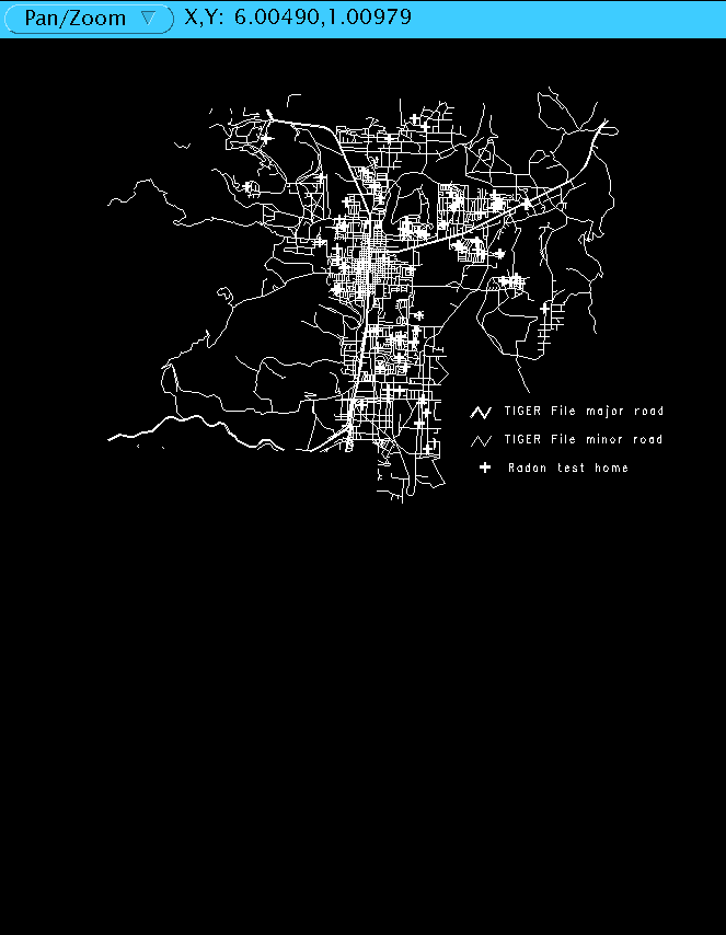
The conversion of test home location paper maps to point coverages was done by on-screen digitizing using the TIGER road network as the background coverage (backcoverage). The level of accuracy of the TIGER files maintained the confidentiality of the test participants. At a scale of 1:100,000, areas of high indoor radon could be shown but individual houses could not be identified. As an example, figure 1 shows the TIGER roads network and radon test homes for a portion of Carson City, Nevada.
Indoor radon point coverages were created for each county, and given the following attributes: canister radon activity (in picocuries per liter of air--pCi/L), canister placement, and type of house tested. The items in the Point Attribute Table (PAT) are shown in table 1. In houses where concurrent tests were made on different levels, the radon activities or readings were entered with lowest level as read1, next lowest level read2 and so forth. Two letter abbreviations used for the character field attributes are shown in table 2.
TABLE 1. Indoor radon coverage Point Attribute Table items and
explanations. See table 2 for abbreviations used for character attributes.

Item         Type         Explanation

house_code   character    Unique identification code
read1        numeric      First canister result
place1       character    Placement location of first canister
read2        numeric      Second canister result
place2       character    Placement location of second canister
read3        numeric      Third canister result
place3       character    Placement location of third canister
read4        numeric      Fourth canister result
place4       character    Placement location of fourth canister
house_type   character    Type of house tested.
TABLE 2.  Explanation of abbreviations for placement and house type used in
the indoor radon Point Attribute Table.

Placement             House Type
BA    basement        SI      single family dwelling
CR    crawl space     AP      apartment
GR    ground floor    CO      condominium
SE    second floor    MO      mobile home
TH    third floor     OF      office
The maximum number of canister tests conducted on a home in any of the three surveys was four. Because the fields for readings are numerical, a value of 0.0 is automatically entered by the software. A value of 0.0 is also a valid result for a canister test. For the former case, the abbreviation NT (no test) was entered in the placement field, and a value of -9999 was entered in the reading field. This allowed easier analysis by selecting reading values greater than -9999, or all points where place2, place3 and/or place4 are not equal to NT.
Using the append command the county coverages were joined to form statewide coverages for each survey. The three survey coverages were likewise joined to form a master statewide coverage. Because the indoor radon potential hazard map was to be an assessment of the potential for radon in living areas of buildings with permanent foundations, a second statewide radon coverage was made in which measurements in crawlspaces and mobile homes were omitted, leaving a total of 1,831 data points.
The role of the U.S. Department of Energy (DOE) National Uranium Resource Evaluation (NURE) aerial gamma-ray survey data in the initial classification of radon hazard potential has been discussed by Duval (1989). For some areas of Nevada these were the only data available for determining radon potential due to the unavailability of indoor radon data. The following description of the data collection and processing is adapted from Duval and Pitkin (1988).
Aerial surveys of the one by two degree quadrangles of the state were flown at a nominal altitude of 400 feet above the surface. East-west flight lines were spaced 1 to 3 miles and north-south tie lines were spaced 12 to 15 miles. Gamma-ray spectrometers recorded the radioactivity of the isotopes bismuth-214 (Bi-214), thallium-208 (Tl-208), and potassium-40 (K-40). The spectrometer measurements are of surficial concentrations to a depth of about 18 inches. The data were corrected for background radiation, altitude variation, and airborne Bi-214. Assuming equilibrium in the uranium and thorium decay series, the concentration of parts per million equivalent uranium (ppm eU) was calculated from the Bi-214, parts per million equivalent thorium (ppm eTh) from Tl-208, and percent potassium (%K) from K-40.
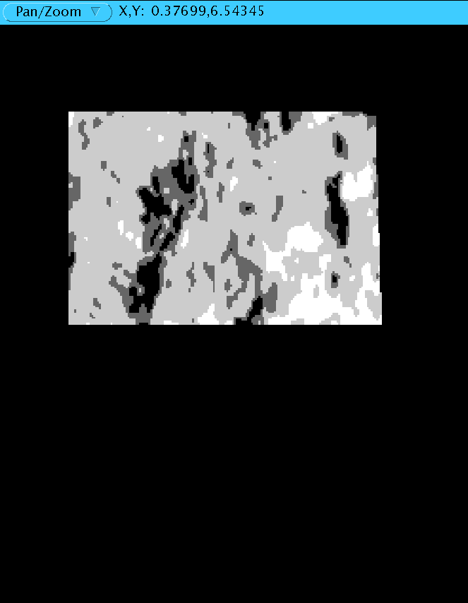
Two versions of the NURE data for Nevada were provided by Joseph Duval of the USGS. The first was a single variable file (SVF) produced from a raster image of Nevada taken from the Equivalent Uranium Map of the Conterminous United States (Duval and others, 1989). The cell size of this image was 1,016 meters and each cell was coded with an eU value. The SVF data were converted to a polygon coverage using the gridpoly command. (The direct conversion from SVF to polygon coverage was done in ArcInfo version 5.0. For version 6.0 and above, svfgrid converts the SVF file to a grid, then the gridpoly command is used.) The resulting coverage had a total of 124,719 polygons for the entire state. Comparing the polygon coverage to early published versions of the Nevada uranium concentrations (Duval, 1988) showed that the data had been through a low pass filter and other standardizing methods in the construction of the national map. While the areas of high and low uranium concentration were the same, the magnitude of the anomalously high areas was decreased. Because of this factor and the difficulty of manipulating such a large number of polygons, we decided that the polygon coverage was unsuitable for analytical purposes. Later on in the project, when GRID modules were added to ArcInfo, the SVF data were transformed into a raster data set using ARC/GRID. The grid was used to produce maps for display purposes only. Figure 2 is a black and white version of this raster data set showing the Elko one by two degree quadrangle. Lighter areas indicate near-surface rock and soils with relatively high uranium content, darker areas indicate low uranium content.
The second version of NURE data provided by Joseph Duval consisted of flight line data of one by two degree quadrangles for the state (18 total) from the national data set. This data set had been resampled from the original continuous measurement along each flight line to one point measurement approximately every 600 feet. The resampling process consisted of the following steps (J. Duval, personal commun., 1992):
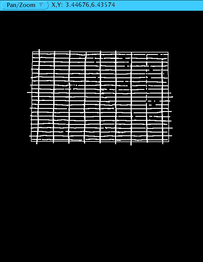
1. A 5-point median filter for removing spikes.The files for this version of the NURE data were provided in ASCII space- delimited format; each line consisting of the information for one data point. The items for each line consist of longitude (decimal seconds), latitude (decimal seconds), potassium (%K), uranium (ppm eU), and thorium (ppm eTh). All values were expressed to six significant figures in scientific notation. Before point coverages could be produced the data had to be manipulated to the correct format. Using Lotus 1-2-3, text editors, and UNIX operating system commands, the files were manipulated into two files per quadrangle. The first file was a location file that contained three items per record: a point identification number, longitude in decimal degrees, and latitude in decimal degrees. The second file was a value file that contained two items per record: the same point identification number as in the location file, and the equivalent uranium concentration (thorium and potassium were not used). Conversion of the location file to a point coverage was accomplished using the generate command with the input specified to be from the location file. (Another method developed later from more experience with ArcInfo and UNIX operating systems simplified the above procedure. The data columns were rearranged and output to ASCII files using the UNIX command "awk." The point coverage was generated using the base tic file units converted to decimal seconds.) Figure 3 shows the flight line point coverage for the Elko one by two degree quadrangle.
Point topology was created with build. In tables, a data table with two items was created using define. The first item was named and defined exactly as the identification number item in the PAT. The second item was defined as numerical with the item name EU for ppm eU. The value files was transferred into the data table using add with the from option specifying the value file. The PAT and the data table were combined on the identification number using joinitem. This procedure was repeated for each of the eighteen one by two degree quadrangles. The eighteen separate point coverages were combined into one large statewide coverage with append. The resulting coverage contained a total of 534,580 points. Using statistics, the following characteristics of the statewide NURE point coverage were calculated: minimum value of 0.0 ppm eU, maximum value 69.2 ppm eU, mean value 2.7 ppm eU, and standard deviation 1.12 ppm eU.
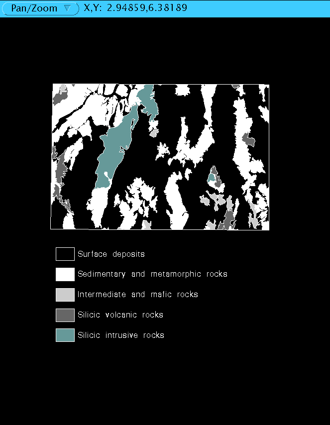
The statewide geologic base used in the analysis was the 1:500,000-scale geologic map of Nevada (Stewart and Carlson, 1978). A digitized representation of this map was produced by the USGS and distributed on CD- ROM (Turner and Bawiec, 1991). The coverage consisted of geologic formation polygons. ArcInfo limits the number of vertices in the arcs of a polygon to 5,000. Because of that limitation, the large areas of Quaternary alluvium on the geologic map were divided into several polygons. Arcs representing faults were present but not attribute-tagged as such. For analytical purposes, a simplified version was created in which fault lines that did not define polygon boundaries were deleted. Totals for the simplified coverage were 20,151 polygons and 102 geologic formations. Figure 4 is a highly simplified version of the resulting digital geology coverage for the Elko one by two degree quadrangle.
The statewide soils coverage used was the Natural Resources Conservation Service (formerly the U.S. Soil Conservation Service) State Soil Geographic Data Base (STATSGO). The STATSGO Data Users Guide (U.S. Department of Agriculture, 1991) states, "This database was designed to be used primarily for regional, multistate, river basin, state and multicounty resource planning, management, and monitoring." The following procedure on the creation of the database is condensed from the Data Users Guide. The soil data were compiled on 1:250,000-scale USGS one by two degree quadrangle maps. Data on detailed soil survey maps were generalized. Where detailed soil survey maps were not available, data on geology, topography, vegetation, and climate were assembled together from LANDSAT images. Soils of like area were studied, and the probable classification and extent of the soils was determined. The map unit composition was determined by sampling areas on the more detailed maps and expanding the data statistically to characterize the whole map unit.
The line data were provided in USGS Digital Line Graph (DLG-3) Optional Distribution Format. The empty INFO attribute files were provided in ArcInfo exchange format. The data to fill the INFO files were provided in variable-length, tab-delimited ASCII format. The DLG-3 files were converted into coverages using the dlgarc command with the optional format designated, and built for polygon topology. The ASCII files were formatted and placed into the attribute files using the shell script provided and INFO commands. This procedure produced 15 attribute tables that provided information such as the composition, layering, and taxonomy of the soil units. Each soil polygon has a map unit identification (MUID), as does each attribute table. The PAT and attribute tables are connected on the MUID using relate.
Preliminary procedures in the production of the state radon hazard map included combining coverages and statistical analysis to determine general characteristics and usability of the data. The first procedure involved standardizing all statewide coverages to match the Lambert conformal projection of the 1:500,000-scale topographic base map of Nevada published by the USGS (1984).
The relating of point data (NURE, indoor radon) to polygon data (geology, soils) was done by the intersect command with the point option. The result was a point coverage where points have the attributes of the underlying polygon. In order to maintain a unique number for geology and soil polygons items geopoly and soilpoly were added to the respective coverage polygon attribute table using additem. This item was calculated to a value unique for each polygon that would carry through the intersections and other processes. The following intersects were done: indoor radon with geology, indoor radon with soils, NURE uranium with geology, and NURE uranium with soils.
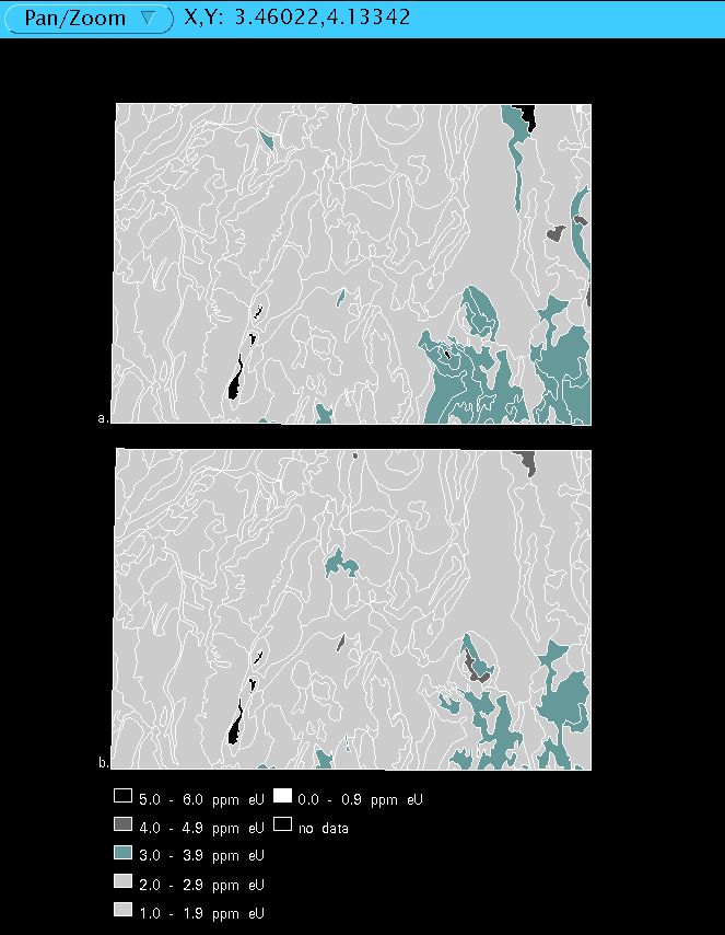
The statistical analysis was done in two ways: averaging for all occurrences of a formation and soil unit, and averaging for individual geologic polygons and soil polygons. Averages calculated over all occurrences of a unit were eventually discarded because, while the occurrences are generally similar, there may be some specific differences affecting radon that could be lost in the generalities. For example, the statewide distribution of Tertiary rhyolitic flows and shallow intrusive rocks (Tr3 on the map of Stewart and Carlson, 1978) is defined by age and general rock composition. However, within this general formation are rock units that have different source magmas with varying amounts of uranium. This would also apply to the alluvium and soil units derived from this source rock. Treating each soil or geologic polygon individually overcomes this problem, but does not allow extrapolation to polygons with no data. Figure 5 shows the difference in the two methods for the Elko one by two degree quadrangle. Figure 5a is the soil unit method, and figure 5b is the soil polygon method.
The following were calculated with geopoly or soilpoly as the appropriate case item: average uranium concentration for each geologic polygon, average uranium concentration for each soil polygon, average indoor radon activity for each geologic polygon, and average indoor radon activity for each soil polygon. The resulting INFO data files were linked back to the polygon coverages using relate. The relate item was geopoly or soilpoly as appropriate. Other numerical analysis consisted of determining the maximum indoor radon measurement, and the percent of indoor radon measurements equal to or greater than 4.0 pCi/L for each soil and geologic polygon. These results were placed in an INFO data table and related to the polygon coverages as for other statistical data tables.
Another preliminary analysis on the statewide data was finding the correlation between soil unit and geologic formation. In order to accomplish this the two statewide polygon coverages were joined using the command union. Because the two sets were created at different scales (geology 1:500,000, soils 1:250,000) the boundaries did not match. The combined coverage was trimmed to fit the 1:500,000-scale state boundary using clip. Further cleaning of the combined coverage entailed removing sliver polygons with areas less than 0.4 square km with the eliminate command. Using the frequency command with geologic formation and soil map unit as the frequency items resulted in a table with 5,989 pairs. The frequency of the pairs ranged from 1 to 875. Graphical representation with ARCPLOT showed that the high frequency pairs occurred in localized areas rather than in a statewide distribution. This analysis reinforced the decision to do analysis on individual polygons.
Preliminary analysis in urban areas consisted of plotting the indoor home survey results with road networks and other geographic features. The purpose of this analysis was to show indoor radon as measured in all types of homes, so the coverage that contained all useful home readings was used. The reading for the lowest livable level of the home was selected and given a symbol to represent the indoor radon activity. The first urban area examined was the western portion of the state. This included the cities of Reno, Carson City, Minden, Gardnerville, and the Lake Tahoe area. Las Vegas and surrounding communities were also analyzed using the same method. The original activity intervals were based on the EPA recommended action limits for indoor radon (U.S. Environmental Protection Agency, 1992); 0.0 to 1.9 pCi/L, 2.0 to 3.9 pCi/L, and equal to or greater 4.0 pCi/L. Before the production of this graphical representation of radon occurrences in urban areas, the data had only been known statistically (maximum, minimum, mean, standard deviation, and percent equal to or greater than 4.0 pCi/L) for geographic areas (state, county, city, and zip code). The graphical representation provided detailed areas of elevated radon activity within zip code areas. In order to determine very high areas of indoor radon, the intervals of 4.0-9.9 pCi/L, 10.0-19.9 pCi/L, and 20.0 pCi/L or greater were added. These are the intervals used in producing the community maps in the NBMG bulletin on radon (Rigby and others, 1994) and an NBMG open-file report of radon occurrences in western Nevada (Christensen and others, 1995).
Where possible the indoor radon potential hazard zones were based on the results of the indoor radon data. In the large rural areas of the state where no indoor data existed, the factors that contribute to indoor radon were evaluated and used to estimate the potential hazard. The first factor considered was uranium content in rocks and soil. No communities in Nevada were close to any significant uranium deposits, so only the NURE data were used in determining radon potential from uranium concentration in soils and near-surface rocks. Joseph Duval (personal commun., 1987) estimates the following radon hazards in homes and buildings from uranium concentration:
0-0.5 ppm eU = very low radon hazard (0% above 4 pCi/L),Three indoor radon hazard zones were defined for Nevada on the basis of indoor radon data and data on likely uranium distribution in soil and near- surface rocks:
High, any one of the following conditions:The polygon attribute table of the combined soil-geology coverage was modified to reflect the above criteria using additem. The attributes and their explanations are listed in table 3. Using the relate command in tables or ARCEDIT, the values in the INFO data tables created by the statistical analysis were placed in the appropriate item in the combined soil-geology coverage polygon attribute table.
TABLE 3. Attribute items and explations of combined soil-geology coverage
         Polygon Attribute Table.

Item        Type                   Explanation

MUID       character     soil map unit identification from STATSGO
soilpoly   integer       unique soil polygon number
eusoil     numeric       average ppm eU for the soil polygon
rnsoil     numeric       average indoor radon for the soil polygon in pCi/L
soilp      numeric       percent indoor radon measurements in the soil polygon
                         equal to or greater than 4.0 pCi/L
soilmax    numeric       maximum indoor radon measurement for the soil polygon
                         in pCi/L
fmatn      character     geologic formation from Stewart and Carlson (1978)
geopoly    integer       unique geology polygon number
eugeo      numeric       average ppm eU for the geology polygon
rngeo      numeric       average indoor radon for the geology polygon in pCi/L
geop       numeric       percent indoor radon measurements in the geology polygon
                         equal to or greater than 4.0 pCi/L
geomax     numerics      maximum indoor radon measurement for the geology polygon
                         in pCi/L
Each criterion was selected and plotted separately. Then the method of selecting the entire potential indoor radon hazard zone was determined. The high and intermediate zones would require the linking of the criteria by using or statements. The low zone criteria would be linked by using and statements. The high hazard zone would be selected by the following logical argument using reselect in the ARCPLOT module:
eusoil >= 4.0 or eugeo >= 4.0 or soilmax >= 20.0 or geomax >= 20.0 or rnsoil >= 4.0 or rngeo >= 4.0 or soilp >= 0.25 or geop >= 0.25.
The intermediate zone would be selected by the following logical argument:
eusoil >= 2.0 and eusoil < 4.0 or eugeo >= 2.0 and eugeo < 4.0 or soilmax >= 4.0 and soilmax < 20.0 or geomax >= 4.0 and geomax < 20.0 or rnsoil >= 2.0 and rnsoil < 4.0 or rngeo >= 2.0 and rngeo < 4.0.
The low zone would be selected by:
eusoil < 2.0 and eugeo < 2.0 and soilmax < 4.0 and geomax < 4.0 and rnsoil < 2.0 and rngeo < 2.0.
Each hazard zone was selected individually and plotted. The resulting maps were overlaid to find areas of overlap. Areas of overlap were reconciled by checking the selection and attribute calculating processes, and any errors were corrected. Once the selection process was corrected an integer item was added to the polygon attribute table of the combined soil-geology coverage called hazard. The zones were selected and calculated to the following values: low zone 5, intermediate zone 10, and high zone 15. All water bodies were selected and given a hazard value of 1. To clean up the coverage the dissolve command on the item hazard was used. Figure 6 is the hazard coverage for the Elko one by two degree Quadrangle.
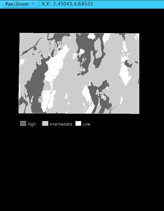
The coverage was plotted at 1:1,000,000-scale for visual inspection. The shade pattern representing hazard zone for polygons with areas less than 10 square km was difficult to distinguish. These small polygons were removed using eliminate. The last change in the hazard coverage was making the hazard attribute a character item with hazard zone being distinguished by high, medium, low, or water. This elimination of the numeric hazard code made the coverage self explanatory to anyone using the hazard zone map. Figure 7 is a simplified version of the radon hazard map.
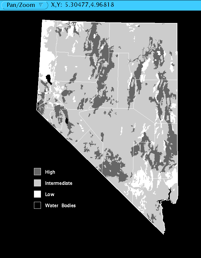
After reviewing the entire GIS process and inspecting the hazard map, we are aware that extensive unpopulated or sparsely populated areas of the state were classified on the basis of uranium content of soils and rocks alone, because no indoor radon measurements were made in these areas. Most of the area of the state was classified as Low or Intermediate radon hazard. The lack of indoor radon measurements introduces some statistical bias into the determination of the hazard of these areas because, if indoor radon data were available, high indoor radon measurements could increase the hazard rating but low measurements would not decrease the rating. This bias is also responsible, to some extent, for the tendency for the High hazard zones to be located in the valleys, where a large majority of Nevada homes are located.
After the indoor radon potential hazard map was refined, some basic analyses on the extent of the zones were made. The areas of each zone were totaled and percentages of the state were calculated. Excluding bodies of water, 19% of the state is in the High hazard zone, 71% is Intermediate, and 10% is Low.
We gratefully acknowledge Don L. Sawatzky of the U.S. Geological Survey Reno Field Office, Lorri Peltz-Lewis of the U.S. Geological Survey Water Resources Division Carson City Office, and Jonathan Price and David A. Davis of NBMG for reviewing the NBMG Special Publication from which this report is taken.
Any use of trade names in this report is for descriptive purposes only and does not imply endorsement by the Nevada Bureau of Mines and Geology or the State of Nevada. Esri is the registered trademark of Environmental Systems Research Institute Inc. Redlands, CA. ArcInfo, Workstation ArcInfo, PC ArcInfo, and ARC/GRID are registered trademarks of Environmental Systems Research, Inc., Redlands, CA. UNIX is a trademark of AT&T. CalComp is a trademark of CalComp Group, Sanders Associates. PC INFO and INFO are trademarks of Henco Software, Inc. Hewlett-Packard is a trademark of Hewlett-Packard. Sun and SPARCstation are trademarks of Sun Microsystems, Inc. PC-File is a trademark of ButtonWare, Inc. Lotus and 1-2-3 are trademarks of Lotus Development Corp. Novajet is a trademark of Encad, Inc.
The soils data used for maps in this report are from the U.S. Soil Conservation Service 1992 State Soil Geographic Data Base (STATSGO), which was compiled at 1:250,000 and designed to be used primarily for regional, multistate, and river basin resource planning, management, and monitoring.
Christensen, L.G., 1995, Geographic information system (GIS) analysis of radon data: Nevada Bureau of Mines and Geology Special Publication 17, 35p.
Christensen, L.G., Johnson, G.L., La Pointe, D.D., Rigby, J.G., and Price, J.G., 1995, Distribution of indoor radon measurements in Carson City, Washoe, Storey, Lyon, and Douglas Counties, Nevada: Nevada Bureau of Mines and Geology Open-File Report 95-1.
Duval, J.S., 1988, Aerial gamma-ray contour maps of regional surface concentrations of potassium, uranium, and thorium in Nevada: U.S Geological Survey Geophysical Investigations Map GP-982, scale 1:750,000.
Duval, J.S., 1989, Indoor radon prediction using gamma-ray spectrometric data [abs.]: EOS, Transactions American Geophysical Union, v. 70., p.496.
Duval, J.S., and Pitkin, J.A., 1988, Interpretation of aerial gamma-ray data for Nevada: U.S. Geological Survey Open-File Report 88-288, 11 p.
Duval, J.S., Jones, W.J., Riggle, F.R., and Pitkin, J.A., 1989, Equivalent uranium map of the conterminous United States: U.S. Geological Survey Open-File Report 89-478, 12 p.
Rigby, J.G., Price, J.G., Christensen, L.G., La Pointe, D.D., Ramelli, A.R., Desilets, M.O., Hess, R.H., and Marshall, S.R., 1994, Radon in Nevada: Nevada Bureau of Mines and Geology Bulletin 108, 76 p.
Stewart J.H., and Carlson, J.E., 1978, Geologic map of Nevada: U.S. Geologic Survey, scale 1:500,000.
Turner, R.M., and Bawiec, W.J., 1991, Geology of Nevada - A digital representation of the 1978 geologic map of Nevada: U.S. Geological Survey Digital Data Series DDS-2.
U.S. Bureau of Census, 1990a, TIGER/Line precensus files, technical documentation: Washington D.C.
U.S. Bureau of Census, 1990b, TIGER/Line precensus files, [machine readable data file]: Washington D.C.
U.S. Department of Agriculture, 1991, State Soil Geographic Data Base (STATSGO) Data users guide: Soil Conservation Service National Soil Survey Center, Lincoln, Nebr., 84 p.
U.S. Environmental Protection Agency, 1992, A citizen's guide to radon (2nd ed.) - the guide to protecting yourself and your family from radon: U.S. Environmental Protection Agency pamphlet ANR-464, 15 p.
U.S. Geological Survey, 1984, State of Nevada [topographic map]: U.S. Geological Survey, Reston, Va., scale 1:500,000.