The Lake Mead National Recreation Area (LMNRA), a unit of the National Park Service (NPS), consists of approximately 0.6 million hectares (1.5 million acres) of aquatic and terrestrial habitats. The management of these resources is complicated by a wide range of issues. With 9.5 million visitors per year, Lake Mead is one of the most highly visited National Park units. Lying at the junction of the Great Basin, Mojave and Sonoran deserts, LMNRA is home to over two dozen species of rare, threatened, or endangered animals and plants. Key responsibilities of the National Park Service (NPS) are to understand, preserve, and manage the variety of landscapes, ecosystems and cultural resources while providing for the public enjoyment of these lands. A Geographic Information System (GIS) can provide excellent tools to address the needs of the NPS for resource management. ArcInfo was the GIS program used because of synergies with other agency activities, data sharing and program development. In the process of developing the program, data sets were obtained in many different formats and brought into the ArcInfo environment. Activities to be facilitated by this program include identification of unique habitats, planning efforts in environmental remediation and restoration evaluation; design of park infra-structure; resource management; impact assessment (abuse/misuse/overuse); and enhancement of communications through graphical displays of resource management alternatives. Project objectives, system configuration, data issues and an example application are discussed in this paper.
Lake Mead National Recreation Area (LMNRA), consists of approximately 0.6 million hectares (1.5 million acres) of aquatic and terrestrial habitats. This area includes Lake Mead and Lake Mohave reservoirs, portions of the lower Colorado River and the surrounding desert uplands of Nevada and Arizona. The LMNRA stretches 210 kilometers (130 miles) from the mouth of the Grand Canyon to Davis Dam, and includes 1240 kilometers (770 miles) of shoreline. The park attracts 9.5 million visitors per year, making it one of the most highly visited units within the National Park System (NPS).
The primary recreational focus of LMNRA is Lake Mead. Approximately 80% of the Park (about 0.5 million hectares or 1.2 million acres) consists of terrestrial areas, which range in elevation from 180 to 2130 meters (600 to 7,000 feet). Portions of this terrestrial area abide as primary habitat for sensitive species such as bighorn sheep. Many of these habitats are relatively inaccessible. As such, only limited natural resource inventories of the terrestrial portion of the LMNRA have been undertaken, and these have mainly been concentrated in the more heavily utilized portions of the Park. LMNRA also contains a number of restricted or specialized habitats (e.g., riparian areas, marshes, spring-fed systems, gypsum outcrops, etc.) that are critical for maintenance of Park biodiversity by serving as habitats for wildlife or for narrow endemics. Many of these specialized habitats have not been adequately inventoried, and so their physical characteristics and biological attributes are not presently known.
Management of 0.6 million hectares (1.5 million acres) of terrestrial and aquatic habitat in the LMNRA is complicated by various issues. Key responsibilities of the National Park Service (NPS) are to understand, preserve, and manage the variety of landscapes, ecosystems and cultural resources while providing for the public enjoyment of these lands. The primary responsibilities of the National Park Service (NPS) are to understand and preserve the variety of landscapes, ecosystems and cultural resources while providing for the public enjoyment of these lands. At project initiation, an interdisciplinary team of research scientists convened at the University of Nevada, Las Vegas (UNLV) to assess and prioritize research, monitoring and mitigation activities needed to ensure protection of the LMNRA's natural resources. Using a planning process known as step-down diagram, the group identified numerous outside influences with potential for degradation of park resources, existing undesirable resource conditions, and basic resource inventories necessary to address resource issues. This step-down process now allows Park resource management to address these resource issues in a systematic manner.
To support a step-down process and to utilize all the pertinent information available for a wide range of resources, a system that can centralize and integrate resource data to support decision making by park managers is needed for the LMNRA. A Geographic Information System (GIS) will be able to meet NPS's need for resource data management and integration. GIS is a computer based information system designed to allow users to collect, store, manage, analyze and display the results of spatial analyses for geographically referenced data.
A GIS plan will facilitate the overall development of the LMNRA information management system by providing short and long term operational guidelines. This GIS plan will outline project objectives, directives and provide recommendations.
The project objective for implementation of GIS at the LMNRA include:
The project boundary for the GIS data base consists of the park area and a buffered area beyond. The extension or buffer provides the ability to capture data which may lie just outside the park boundary which by character may influence areas within the park boundary. The project boundary for LMNRA is shown in figure 1. The boundary consists of areas within Universal Transverse Mercator (UTM) Zone 11 and UTM Zone 12. The project boundary resides within the following eight U.S. Geological 30 by 60 minute series maps:
Figure 1: The LMNRA project boundary.

In the early stages of GIS data base development, a late 1992 initiation through a co-operative agreement with UNLV and the park service has identified the computer hardware requirements, data base structure and resource themes necessary for a GIS system. The UNLV Transportation Research Center (TRC) utilizes a 486 based micro- computer, two X-terminal stations and a SUN 6-690 mini-computer for this project. The 486 computer and X-terminals exist within the TRC lab while the SUN 6-690 resides at National Supercomputer Center for Energy and the Environment (NSCEE) at UNLV. Access to the SUN 6-690 is made possible through connection of high speed data transmission cable directly to SUN 6-690 mini-computer. TRC also has a 3 by 4 foot Calcomp digitizer that is connected to the micro-computer with PC ARC/INFO software. This PC also facilitates coverage creation and hardcopy output. A Hewlett Packard DraftMaster II (eight pen carousel plotter) that is capable of producing large E size plots, and two HP DeskJet 500C color DeskJet printers/plotters capable of producing legal size plots are utilized at the TRC for this project.
The rapid change in GIS and computer technology has made it difficult to predict the characteristics of equipment that will be needed in the future. Currently, mass storage data needs are provided by magnetic media and hard drive technology. As data storage requirements grow, other technologies such as Optical Laser Disks may be assessed. The existing coverages currently occupy more than one gigabyte of hard disk space. Additional storage space is required as new data layers are created for the project. It is also important to note that there is a difference between the computer memory needed to store data, and the computer memory needed to run applications. Since running an application often involves the creation of numerous intermediate and derivative files and data sets, total memory requirements can be many times as large as the simple data storage requirement. Hardcopy output improvements may be obtained by using more sophisticated output devices such as an electrostatic plotter.
Software needs include maintaining licensing agreements and evaluating new software packages. The ArcInfo software licensing agreement and other software modules that perform various analytical tasks are constantly upgraded with improvements.
Global Positioning System (GPS) receivers have been utilized by the LMNRA since 1993. GPS can be a good tool to identify and correct the location(s) of major error(s) in the GIS data base. The GPS can also be used to accurately map and identify locations of archaeological sites, threatened and endangered plant species, property boundaries, facilities and landscape features. Through a cooperative agreement, LMNRA utilizes a base station maintained by the Bureau of Land Management for high accuracy differential positioning.
The goal of this GIS Plan is to have a system that will integrate geographic data from a variety of sources which also has a comprehensive digital information system. Several GIS software packages were reviewed, including GRASS and ArcInfo. ArcInfo provides the means to manage, manipulate, analyze, import/export, and convert varying data and generate product output. More specifically, the capabilities of ArcInfo for the LMNRA GIS Plan include: (1) inventory data assessment of park resources, including the identification of unique habitats; (2) guidance for planning efforts in environmental remediation and restoration evaluation; (3) design and maintenance of park infra-structure; (4) water resources management; (5) resources trend analysis; (6) impact assessment (abuse/misuse/overuse), and (7) product generation or spatial analyses of resources in graphical or tabular formats.
ArcInfo also contains various sophisticated individual software modules for specialized applications. GRID, a raster based geoprocessing tool for simple and complex grid-cell analyses and TIN, a surface modeling package for creating, storing and analyzing surface information are two specific modules applicable to the LMNRA GIS program. The GRID module is capable of performing spatial modeling by dividing space into discrete units know as cells. GRID can manipulate both vector and raster data sets utilizing Boolean and Map algebra. The Triangular Irregular Network (TIN) module allows users to make use of Digital Elevation Models (DEMs) to conduct surface analyses. Another module, a Data Integrator, provides the connection capabilities with external data bases such as ORACLE, SYBASE and INGRES.
There are a number of possible ways that an off-site facility can establish a communication link to the system located at UNLV. Connectivity options to ArcInfo include: internet, modem and laser hardware. An internet connection would be the most favorable of the three. A more common method is by dialing into the system from a remote site using a remote host computer with a high speed modem and graphic emulation communication software. Dedicated transmission lines will provide faster transmission rates. For facilities that are within the immediate vicinity of the UNLV campus, laser technology can provide connectivity for short distances.
Another way of obtaining access to an ArcInfo computing system and data sets by the park service is to have complete on-site hardware peripherals and ArcInfo software. Coverages, data and customized menus created by TRC that are stored at UNLV facilities can be transferred to park service facilities electronically or by magnetic tapes. The compatibility issue in hardware peripherals such as tape drives is also critical for data interchange and transfer. Other software issues that need consideration include operating system and data file storage directory paths. The selection of an operating system will ultimately affect commands to be used in customized menus and how files are handled. It is suggested that all existing park service hardware peripherals and software be evaluated before acquiring a new system or choosing a system configuration set up.
One of the early priorities of data acquisition is to inventory the resources of the LMNRA authority expeditiously to obtain a comprehensive data base that will enable resource management staff to make informed decisions and to direct further research efforts in the Park. To accomplish this goal, ArcInfo will be utilized to provide digitized maps of the geology, topography, hydrology, vegetation and wildlife of LMNRA, all of which can be linked to a digital geographic location. Scientists and engineers at UNLV are already acquiring information on the Park using ArcInfo. This should provide an important baseline for efforts to inventory the resources of LMNRA.
At this stage in the development of a GIS for LMNRA, efforts are being concentrated on the development of accurate base data. Comprehensive base information is needed to assist resource managers in their mission of protecting valuable sensitive resources and the biodiversity of the desert ecosystem within and adjacent to the boundaries of LMNRA. 7.5" Digital Elevation Models (DEMs) produced by USGS are an important component of this database. In the GIS, elevation, aspect, and slope information will allow searches for highest probability of archaeological sites, likely lambing grounds of bighorn sheep, possible locations of hazardous mine shafts, probable habitat of desert tortoise, bear paw poppy, gila monsters and other species of concern. LMNRA has worked with UNLV over the past several years to develop base data for the park and surrounding areas. The data base is currently housed at UNLV.
Most of the existing data in TRC were obtained from the NPS Service Center in Denver, Colorado. These data consist of boundaries and locations of features in the format of Digital Exchange File (DXF) and 1:24000 scale Digital Elevation Model (DEM) and Digital Line Graph (DLG). Most of the data were obtained in DXF format that originated from SAGIS files that were imported into AutoCAD. These DXF data are referenced using Universal Transverse Mercator (UTM) Zone 11 and Zone 12. DXF data are created by exporting AutoCAD files. These DXF data are then imported into ArcInfo.
A list of themes have been suggested by the Park Service as primary candidates for GIS digitization within the LMNRA. These Themes include:
Digital data is definitely the most expensive element of the GIS. Funding will be sought to acquire existing data sets that conform to the park's requirements and NPS standards. All input data must be compatible with the established GIS format before it is used. The precision and accuracy of the input data, and the procedures used to import data into the GIS will be documented according to standard procedures.
Files were obtained from the NPS Service Center in DXF, DLG and DEM formats. Most of these files contain boundaries for various zones and data themes. Such themes include vegetation, trails, washes, geology, rare plant locations, endangered wildlife species, and Township-Range-Section boundaries. All these files have been converted into an ArcInfo format. However, these coverages were in different scales and coordinate systems. Almost all boundary, point and line coverages currently do not contain attribute data. Though efforts were made to identify the degree of accuracy of these data themes, the exact accuracy level is yet to be determined.
Other hardcopy maps that contain geology and vegetation themes provided by the Park Service are currently being digitized into ArcInfo coverages. Since supplementary attribute data are not available in digital format for these coverages, manual input of attribute data is required. Most GIS system parameters such as projection type, coordinate system, units and zonal type were identified by project investigators for the LMNRA mapping program. A master reference file at 7.5 minute intervals in a Universal Transverse Mercator projection at Zone 11 was created for referencing. Some of the data layers and themes needed by project investigators were partially identified. Agencies other than the Park Service were contacted for potential data sources.
GIS specialist(s) will maintain current metadata documentation on each data layer in accordance with federal government standards. The documentation will include information such as: storage location, source, dates of collection, themes, coverage creation, scale, projection type, map units, principal investigator, USGS quad, property ownership and known deficiencies. In addition to maintaining metadata documentation, a data dictionary containing a list of coverages with location and format information are stored in a WordPerfect format.
A primary benefit provided by a GIS is the capability to integrate data derived from a wide variety of sources. The quality of the analysis is defined by the scale and precision of the source material. The multiple conversion of files from SAGIS to AutoCAD, and from AutoCAD to ArcInfo has brought attention to data accuracy. Data quality should be made a primary concern.
From the inception of data collection, there are problems, concerns and questions associated with data accuracy. First, is the integrity of a feature compromised? Second, is the feature identified, or attributed correctly? Several steps can be taken to ensure data accuracy. These include the following:
NSCEE is currently responsible for routinely backing up the data base and operating system. Data storage cartridges or magnetic tapes are used as backup media and are dated, labeled and stored in a safe and secure place. It is recommended that during the periods of intensive data conversion, backups be performed daily.
LMNRA maintains a close working relationship with other federal, state and local agencies responsible for managing lands adjacent to its boundaries. It is recommended that data requests be made in a documented format to the Superintendent of LMNRA defining data needs and proposed use. A non-disclosure agreement will be required to guard against unauthorized data use.
Due to various sensitive issues, not all of the data developed are available for distribution. Data that are part of an ongoing project or that contain sensitive information will not be released.
A considerable amount of time and effort is required to effectively learn how to use a GIS system. Though almost all GIS vendors are developing more user friendly software products, a substantial amount of time is required to familiarize users to a system before performing sophisticated analysis. To fully develop the GIS system, the NPS has created, and filled, a full-time GIS specialist position. The GIS specialist will create new data layers when needed and perform data base design and management.
The great amount of data layers and application analyses that are required by the park service and other interdivisional cooperative project investigators may require more than one GIS analyst. For security purposes, it is therefore recommended that a system administrator be designated to oversee data base integrity and security. The system administrator will be responsible for systematically backing up data and software and updating software when new releases are available.
This interdivisional cooperative project will have users from all divisions that will access the same data sets. There will also be instances where data sets are being accessed by more than one user at any one time. All project investigators and system users must coordinate their activities with the system administrator. When a part of the system is not being used to complete a project, and it will not interfere with a priority project, other users may sign on to the system and access the data. Working on projects will take priority over teaching others on how to use the system. In a multiple user networked environment, there will also be instances when the network is saturated with processes that create bottle-neck situation. During this period, the central processing unit usually will experience a tremendous delay in data information processing and the ability to generate results. With assigning priority levels to different users, network bottle-neck situation can be avoided.
The evolutionary advances in computer hardware and software technology have and will continue to affect the development of GIS technology. GIS technology is in a very dynamic stage and is constantly being updated with new capabilities. To maintain a high degree of expertise, and to keep up with changes in GIS technology, a continuing GIS training and education program needs to be implemented. The training and education program will include specific software and its application. All park service personnel responsible for resource management are recommended to be part of an application training program.
GIS can be an efficient analytical tool, providing solutions for resource management problems. It is recommended that all park service personnel involved in resource management and the GIS analyst be exposed to the various possibilities of GIS applications. This can be achieved by attending GIS workshops, user conferences and seminars. Participation and attendance of GIS user group meetings will develop an awareness of the wide possibilities of applications and techniques in GIS technology. Most software vendors also provide one person registration each year to attend their user conference with the renewal of the software license. Many local entities such as county agencies and community college also offer GIS workshops and classes.
It is the intent of the NPS to work cooperatively with other agencies that are involved in this project. It will be the responsibility of the system users to share ongoing applications, and display the graphics and tabular results of analysis. Proper planning with other organizations, and meeting with project investigators before the beginning of a project will derive a better result. During the planning process, data themes required by individual project investigators and training needs required by staff members must be identified. All project investigators must coordinate with GIS analysts for all GIS related activities and update data bases whenever new data becomes available.
User-friendly menus and interfaces will be developed by TRC staff to assist other related organizations in performing their analysis. TRC will help train the staff of other organizations to familiarize and use the ArcInfo easy-to-use menus and interfaces. It is important that modular approach be used when developing these menus and interfaces. Functions performed in a module are usually isolated from other modules, and if changes are required, only one module needs to be modified.
All project related organizations could also provide research assistants to assist the TRC in achieving these goals and the areas of their particular needs. Project investigators and their research assistants should also provide the GIS analyst with detailed information regarding format of the data set(s) required for their application(s).
In 1992, the National Park Service (NPS) set aside 198,253 acres of LMNRA as a Desert Wildlife Management Area (DWMA). This conserved habitat, managed under more restrictive land use guidelines, was established as part of the Habitat Conservation Plan (HCP) for the threatened desert tortoise (Gopherus agassizii) in Clark County, Nevada.
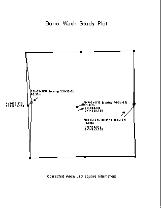
In order to develop a long-term monitoring program for desert tortoises, a number of permanent study plots have been established. Two one square mile study plots were established in 1992 using conventional surveying techniques. In 1995, six additional one square kilometer plots were set up using Global Positioning System (GPS) receivers. Through a cooperative agreement, LMNRA utilizes a base station maintained by the Bureau of Land Management for differential positioning. As the differential corrections were not available to field personnel in real time, setting up the plots required two field trips. GPS receivers were used to navigate as close as possible to the predetermined corner coordinates of the study plots. These corners were marked and GPS position fixes were taken for each. When differential corrections were made to these positions, the coordinate geometry functions of ArcInfo GIS software were used to quickly determine the final bearing and distance corrections required in the field (Figure 2). These corrections were made, corner markers were moved accordingly, and final GPS positions were taken in a second trip to the field. This procedure has proved to be a cost effective and sufficiently accurate method of setting up study plots for long term monitoring.
LMNRA has been using GPS receivers since 1993 to systematically collect locational and specific attribute data on desert tortoises within the permanent study plots. ARCPLOT has been used to construct maps of the study plots to assist field personnel in planning the tortoise surveys. Although detailed analysis is still forthcoming, the data has been input into an ArcInfo GIS database and maps have also been developed to visualize the survey results (Figure 3). Extensive transects for tortoise sign will be conducted in 1995 using GPS technology. All of this data will be entered into LMNRA's developing GIS in order to define the extent of tortoise habitat and relative population densities within the DWMA.
In 1994, an extensive burro inventory was conducted by helicopter using a GPS receiver to collect location and attribute data. This data, incorporated into the park's GIS, will help resource managers to identify and plan for potential impacts to sensitive resources, including critical habitat of the desert tortoise. Detailed analysis of this data will begin once the park has acquired the necessary GIS hardware and software in 1995.
Figure 2: A tortoise study plot with corrections calculated using ArcInfo coordinate geometry functions.
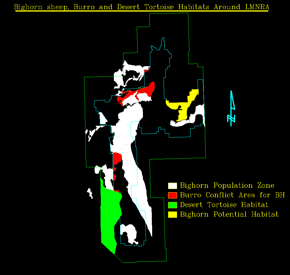
An example of various habitats around the LMNRA.
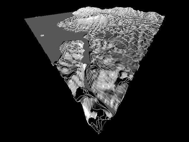
A 3 dimensional graphic display generated from the Hoover Dam Quadrangle DEM with a 50 meter contour overlay.
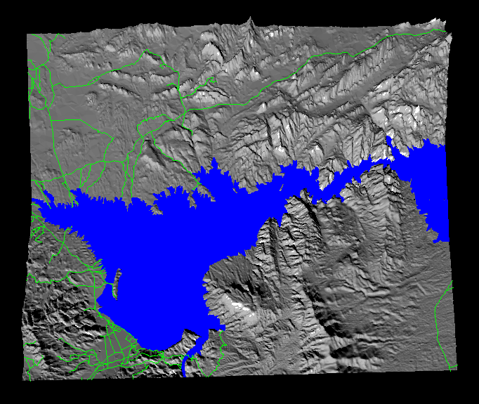
A 3 dimensional graphic display of the Lake Mead lower basin generated from a DEM showing water boundaries and roadways.
The authors are grateful to several organizations and individuals who have played significant roles in various capacities related to the project that formed the basis of this paper. They include the National Park Service, Kent Turner and Bill Burke; National Park Service Cooperative Park Studies Unit, Charles Douglas; UNLV National Supercomputing Center for Energy and the Environment, Mike Ekedahl and Joe Lombardo; and UNLV Transportation Research Center, Jeffery Jensen, Soon-Tin Lim, Said Sadri, Reginald Souleyrette, and Xiao-Hui Yu.