This paper summarizes the three types of real world applications of the GIS/GPS
technologies.
A discussion of some real world issues such as GPS data accuracy, efficiency and effectiveness, and availability of quality maps and attribute data in applying GIS/GPS technologies are presented.
GIS is an information technology that analyzes, stores, and displays both spatial and
non-spatial data. It combines the power of a relational database software and the
power of a CAD package. It offers the potential to assemble and process data from
diverse sources and present it in an easily understood graphical format. Geographic
Information Systems (GIS) are recognized as a very useful tool in transportation
planning, engineering and management. A Global Positioning System (GPS) is a
positioning and navigational system.
A GPS receiver receives the signal broadcast by satellites and uses information
contained in the signal to calculate the position of the receiver. The positional
accuracy that can be achieved with GPS ranges from 100 meters to millimeters,
depending on the type of receiver used and if the data collected are differentially
corrected either in real time or in a post process fashion. This space-age technology
has found a variety of applications in natural resource management, urban
development/analysis, agriculture, and social sciences.
For the past several years, Lee Engineering has been actively exploring these new
technologies in solving a variety of transportation problems. Our GIS/GPS
experiences can be summarized into three general types of applications: 1) GPS as a
data collection device, 2) GIS as transportation database manager, and 3) GPS as
traffic design aid.
GPS AS A DATA COLLECTION DEVICE
Travel Speed Data Collection
GPS was used to collect travel speed data for a network travel speed study in the
metropolitan Phoenix area. The study included data collection for 61 routes which
comprised over 900 miles of arterials, freeways and HOV lanes. For each route, a
minimum of three runs were made during a designated time period (either AM, Mid-
day or PM). The data collection vehicles or test vehicles were equipped with GPS
units which were set to record the date, time, vehicle position and velocity of the
vehicle on a two-second sampling interval. Each test vehicle was also equipped with
a portable computer used to record any event that caused a stop delay (defined as a
speed of five miles per hour or less) other than general intersection delays. The data
collection effort resulted in the collection of more than forty-mega bytes of GPS and
event data. The GPS data were downloaded into a PC and differentially corrected
using base station data which was provided by Maricopa County. The corrected GPS
data were overlaid on a base map of the metropolitan Phoenix area for validity
checking in ArcInfo before being further processed by ArcInfo, FoxPro and SAS
packages. The full description of GPS data collection and processing can be found
in "A GIS/GPS System Design for Network Travel Time Study" presented at the 74th
Annual Meeting of the Transportation Research Board, preprint number 950332, 1995.
Traffic Sign Inventory Data Collection
GPS was used as the primary data collection tool for traffic sign inventories for the
White House/Washington Mall areas and for Mount Rainier National Park. To
accomplish the data collection activities, a program was developed, using the GPS
vendor's software, to query the data collector for sign attribute information. The
position of the sign was determined by the GPS unit while the data collector entered
the attribute information into a hand-held computer which is part of GPS unit. At the
end of each data collection day, the data was downloaded to the PC and differentially
corrected (post-process). As part of the data collection activities for the White
House/Washington Mall areas, a sketch was made and ultimately drawn in CADD, of
each unique sign. For the Mount Rainier project, a color digital image of each unique
sign was collected using an 8mm video recorder. For both inventories the sign image
was related to attribute and location information through a sign code. A unique sign
code was assigned to each unique sign legend and layout.
Roadway Inventory Data Collection
GPS was used to collect existing roadway features for several design projects which
did not have complete as-built roadway inventories. In one data collection effort for
a 17-mile-long scenic route, the existing no-passing zone striping and signing, location
of turnouts and pull-outs, mile post markers and locations (beginning and end) of
bridges were collected. To increase efficiency, bar codes were defined for different
roadway features of interest before the data collection. To collect data, two data
collection personnel used a vehicle equipped with a GPS unit. One data collector
drove the vehicle and notified the second data collector of an approaching feature.
The second data collector recorded the feature by scanning the matching feature code
using a bar code reader as the vehicle passed by. To increase accuracy, more than one
run was conducted. After differential correction, the GPS point data representing the
events were processed through dynamic segmentation in ArcInfo. The analysis
resulted in a mile-log report of all the events collected with satisfactory accuracy when
checked against the available milepost log of the route.
GIS AS TRANSPORTATION DATABASE MANAGER
Identifying Roadway Needs
The Arizona County Roadway Needs Study project recently completed by Lee
Engineering created an improved system for estimating needed improvements on more
than 20,000 miles of county roads in the state of Arizona. GIS was used primarily to
establish the roadway inventories and to map the terrain conditions. While all the
counties kept fairly complete roadway databases, only a few have their roadway
database tied to GIS. In order to create a uniform GIS-based roadway database, Lee
Engineering used TIGER maps from the 1990 census as the base map for those
counties that did not have a GIS mapping of their own.
Two major obstacles were encountered in creating the GIS county roadway inventory.
The first was the map deficiencies. For this project the map accuracy was not as an
important issue as the completeness and correctness of the map for the study. Manual
effort went into updating the base map as well as connecting the unconnected
roadways in the map. The second and the biggest challenge was mapping the existing
roadway segments stored in the various database or spreadsheet formats into the base
maps. Since there were no consistent county road naming conventions and very few
roads in the TIGER base maps had names assigned, automatic segment mapping was
out of the question. Lee Engineering had roadway inventory segments manually
mapped out onto paper maps and had a unique identification number assigned to each
segment. Then the segments identified on the paper maps were mapped into the base
map manually through the help of AML (ArcInfo Macro Language) programs.
Generating Universe Roadway Segments for HPMS
The Highway Performance Monitoring System (HPMS) is a federally mandated
program to track the features of roadways in the entire United States. The aim of the
HPMS project for the Maricopa Association of Governments (MAG) was to set a
spatial database of both the universe roadway segment and the sample panel segments
in Maricopa County. The HPMS does not require state agencies to maintain the data
on every segment of roadway within a state; however, it does require the state to
maintain information on those segments which are not functionally classified as local
roads.
One major challenge was to inventory the universe roadway segments in a specified
format. The two major segmentation criteria were homogeneity and the limited-
length criteria. This required that functional and physical features, including
ownership or jurisdiction, of a segment be uniform within a roadway segment of a
limited length. The information available to Lee Engineering was a couple of
boundary maps and two roadway network base maps for Maricopa County.
The two base maps were maintained by the MAG Transportation Planning
Organization and by the Maricopa County Department of Transportation. The maps
had different file formats, different topological accuracies and different data attributes.
The base map which contained the most important road segment attribute - roadway
functional classification - had inferior accuracy. Adding further to the challenge, the
two maps did not share the same street naming conventions and the physical roadway
features such as number of lanes and presence of roadway medians were not available
in either map.
The aim of the inventory process was to create a list of segments conforming to the
HPMS criteria using the best data and highest geographical accuracy available to Lee
Engineering. A four step segmentation process was defined. The first step assigned
jurisdiction codes to the nodes in the functional classification map by overlaying
boundary coverages representing the three areas: urban and small urban, air quality,
and rural areas. Having both functional classfication and HPMS area information, the
map was then broken into segments homogenous in functional classification and
jurisdiction through programming. The second step was the creation of a street name
look-up table for converting street names used in one map to the names used in the
other map. The segment reference names (in the form of on-street from-street to-
street) of roadway segment database generated in step one were then converted to the
names used by the more accurate map. The third step mapped the segments created
and modified in the previous two steps into the more accurate map through a mapping
program developed by the Maricopa County Department of Transportation. This
mapping process resulted in a new coverage with both desirable topological accuracy
and functional classification information. This also resulted in a smaller coverage in
which each arc represented one segment homogenous in both ownership and
functional classification. The forth step added the physical features along defined
segments. Data collection personnel field checked the roadway physical features and
the unpopulated database features were manually coded into the GIS database.
User Information Management Systems
For the White House/Washington Mall and Mount Rainier projects, a GIS based sign
inventory/management system was created to query sign attribute information,
including sign location and sign images, on a base map. The management system
allows the user to easily pan and zoom into areas of the coverage and display the
attribute information and a picture. For the Mount Rainier project, a PC database
management system was also created which allows the user to access and view the
attribute information and issue maintenance work orders.
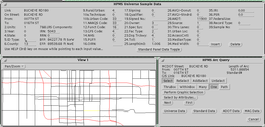
For the HPMS project, Lee Engineering developed a user interface for maintaining
and reporting the complicated and voluminous HPMS data. The main functions are
a) geographical editing of the HPMS database. b) generating various roadway feature
maps. c) reporting data in user-defined formats as well as the format required by the
Federal Highway Administration. d) calculating vehicle-miles of travel for various
boundaries. Figure 1 shows a screen of the HPMS interface system.
GPS AS TRAFFIC DESIGN AID
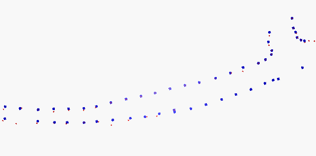
GIS and GPS are generally used as tools for inventory management systems. However, Lee Engineering recently experimented with integrating the traffic sign data captured through GPS with CADD for signing design. For a 17-mile long signing project, Lee Engineering used GPS to collect such sign information as sign dimensions, legends, sign codes, post types, number of posts, orientations and sign locations. Following differential correction, the GPS data (including the location information in the state plane system) were put in a dBase file.In MicroStation, a MDL (MicroStation Development Language) program was developed to read this database table and place in the CADD file the cells representing signs on post or on posts and rotate the sign in the correct orientation. The program at the same time made the "hot link" between the database records and the graphic cells in the drawing. The "hot link" allowed the designer to make modifications to the database and have these changes automatically updated in CADD files. Another MDL program was developed to display the desirable attributes such as post ID and sign code for each individual sign. Any design changes, such as placement of new signs, removal or relocation of existing signs, were made both to the drawing and to the database. By maintaining a current sign database, generating construction cost estimates and signing summary design sheets became a more efficient and accurate process. For one striping design project, Lee Engineering experimented using GPS to develop as-build road geometry when as-built plans were not available and where field survey was difficult. The roadway geometries for this project consisted of two horizontal curves connected by a very short tangent coming into a T-intersection. The existing geometry was further complicated by the partial widening of the pavement both approaching and leaving the intersection. A GPS unit capable of real time correction was used to pin-point the locations of a series of "control points" along the edge of pavement. The data, when imported into MicroStation, showed a very satisfactory result. Figure 2 shows the GPS data imported into MicroStation. The blue points represent the real-time corrected GPS data and the red points represent the post- corrected GPS data.
DISCUSSIONS AND CONCLUSIONS
GPS Accuracy and GPS Signal Reception
Location data collected through GPS units have intrinsic random errors that cannot be
totally eliminated. To obtain the higher level of accuracy for any receiver requires
differential correction, a process of placing a receiver on a known location, called a
base station, and using the collected satellite data to adjust GPS positions computed
by other receivers at unknown locations during the same time period. The accuracy
after differential correction in, Lee's experience, has been in the range of 2-5 meters.
For most of Lee's applications, the level of accuracy seems to be adequate. However,
the availability of base station data for post-differential correction has been a major
issue. In the travel speed study, a few test vehicle runs had to be discarded and
additional runs made because the base station failed to operate properly during the
time the GPS data were being collected.
Bad GPS signal reception results in missing data. This has been another major issue.
The GPS signal broadcast by the satellites are susceptible to being blocked of tall
buildings, bridges and even trees. Another type of reception error is due to
unfavorable satellite configurations at particular times and particular locations of the
GPS receiver. In the White House / Washington Mall and Mount Rainier projects,
GPS reception errors made manual methods a necessary backup.
It should be noted that through improvements to hardware and software algorithms,
accuracy is increasing to 1 meter level for non-survey level GPS units. The potential
reception problems are also being reduced.
GPS vs Manual Data Collection
Due to GPS reception problems mentioned above, it was necessary to collect some
attribute information using manual methods in the White House/Washington Mall
project. An analysis was conducted which compared the amount of time required
using both methods, GPS and manual, to collect and post process the sign inventory
data. It was found that signing data collection and post-processing with the GPS units
required 4.6 man-minutes per sign verses 5.5 man-minutes per sign using the manual
method. The signs collected using the GPS equipment required a longer data
collection time but were post-processed with much less time. The longer field data
collection time using GPS was due to the fact that 180 positions were collected at each
sign location in order to obtain the best accuracy of the GPS equipment used for the
task. At the rate of one position per second, GPS data collection required a minimum
of 3 minute at each sign location. The full description of the analysis can be found
in "Comparison of two Sign Inventory Data Collection Techniques for Geographic
Information Systems", published in Transportation Research Record No. 1429,
Planning and Administration, Multimodal Priority Setting and Application of
Geographic Information Systems, Transportation Research Board, National Research
Council.
Three points should be noted:
- The improvements to GPS hardware and software have made GPS even more efficient
than manual data collection. Not only does real-time differential GPS significantly
reduce the post process time by eliminating the need for post-differential correction,
it requires much less data acquisition time as well. One second per position
with real-time differential GPS achieves the same level of positional accuracy
as 3 minutes per position using non real-time differential GPS.
- While the above comparison was only made for traffic sign data collection and
post-processing, it is felt that many aspects of the comparison are applicable to others
types of data collection and processing.
- Other factors, such as equipment cost, personnel cost and availability
should also be considered.
GPS Data Post Process and Base Map Accuracy
However accurate the GPS data may be, they represent a discrete set of two or three
dimensional points, But historically, the majority of transportation data have been in
a linear model. The points only make sense in the context of a linear roadway
network. The dynamic segmentation functions of GIS are often used to convert
discrete GPS points to points referencing continuous line segments, i.e., the roadway
network. While the dynamic segmentation functions have become standard features
for most GIS packages, the accuracy of dynamic segmentation results rely very
heavily on the accuracy of the base map.
Unfortunately, generation and maintenance of accurate base maps require huge
resources and therefore are not often available. Lee Engineering has been fortunate
to have had access to a fairly accurate Maricopa County map for most projects. This
road network map was digitized from 1:24,000 scale aerial-photographs in 1992,
through a joint effort of the Maricopa County Department of Transportation and the
Arizona Department of Transportation. The map claims a relative accuracy of 25 feet.
Most of the TIGER-based maps have a reputation for having incomplete and
inaccurate topological and attribute information. It is not recommended to use TIGER
map to map GPS points in most engineering applications; however, TIGER maps can
be adequate sources for many transportation planning applications. The results of
using TIGER files for the roadway needs study were very satisfactory.
Truth in GIS Data
With GIS being the information integrator of data from different sources and different
types, more than ever before, agencies are relying on each other for data. As a result,
inaccurate data, together with accurate data are being spread across disciplines very
easily and very quickly. Unfortunately, the quality and availability of data has been
one of major obstacles in the use of GIS. Some of Lee's experiences indicate that the
most difficult aspects of GIS are not necessary at the technical level, but at the data
acquisition and validation level.
Lee's experiences in using GIS/GPS technologies have been successful. It is Lee's
believe that the GIS/GPS technologies are valuable tools that can help bring quality
and efficiency to our profession. However, knowing the right technologies for the
right applications, and knowing what is involved in using these technologies are the
precursors to success.