Wetland delineation remains a problematic issue for governmental agencies involved with environmental monitoring. Remotely sensed data, particularly aerial photographs, are important for mapping wetlands at regional scales. New digital remote sensing technologies (e.g., medium- to high-resolution multiband satellite and airborne imagery of visible, near-infrared, mid-infrared, thermal, and radar spectral regions) may improve National Wetlands Inventory (NWI) mapping efforts by increasing map accuracy and reducing map production costs. In response, NASA's Commercial Remote Sensing Program Office performed a study to evaluate the utility of commercially available remote sensing technology for deriving wetland classification and mapping products for the NWI. This paper discusses GIS techniques used to assist this investigation. This project involved processing each remotely sensed data set into wetness maps for comparisons against NWI maps and GPS-based field survey data. GIS tools found in ArcInfo software proved to be indispensable for quantifying and visualizing comparisons of test and reference wetness maps. GISs also assisted in wetness signature evaluation and development by enabling analysts to cross-tabulate unsupervised classifications of remotely sensed data with NWI wetness maps.
Wetland delineation remains a problematic issue for governmental agencies involved with environmental monitoring. Remotely sensed data, particularly aerial photographs, are important for mapping wetlands at regional scales. New digital remote sensing technologies (e.g., medium- to high-resolution multiband satellite and airborne imagery of visible, near-infrared, mid- infrared, thermal, and radar spectral regions) may improve National Wetlands Inventory (NWI) mapping efforts by increasing map accuracy and reducing map production costs. NASA's Commercial Remote Sensing Program Office performed a study to evaluate the utility of commercially available remote sensing technology for deriving wetland classification and mapping products for the NWI. This paper discusses GIS techniques used in this study. Remotely sensed data products often constitute an invaluable component of GISs, and a great deal of software development has taken place to aid the use of remotely sensed data in GISs. Modern GISs give users the ability to conduct visual and quantitative analysis involving multiple kinds of digital spatial data, including remotely sensed imagery. In addition, GISs provide several tools for working with raster remotely sensed and thematic imagery. For example, a screen display of remotely sensed imagery with co-registered spatial data can enhance spatial data visualization and interpretation. GISs also allow quantitative comparisons between classified maps from remotely sensed data and other thematic data sets. In addition, some of the more advanced GIS software packages (e.g., ArcInfo) now include basic functions for processing and analyzing remote sensing data, such as image screen displays, georeferencing, and classification.
Additional data sets were acquired for evaluation of wetland mapping results: 1) a GPS-based survey of wetland boundaries, 2) GPS-based locations of wells located across field-delineated wetness gradients, 3) National Wetland Inventory digital maps produced at 1:24,000 scale by the U.S. Fish and Wildlife Service (USFWS), 4) 1:24,000 U.S. Geological Survey topographic maps, and (5) 1:8,000 color infrared (CIR) aerial photography acquired in 1995 during the same mission as the airborne daytime multispectral imagery.
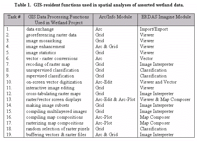 Table 1 lists several GIS-based data processing routines used to produce and/or evaluate the wetness maps for the study. Remote sensing specialists processed each remotely sensed data set into wetness maps by subjecting each raw data set to unsupervised ISODATA classification into 25 spectral clusters. They also prepared an NWI map from 1989 aerial photography by downloading it from the USFWS Internet site, importing it into ArcInfo, and recoding the soil moisture regime into a wetness map. Each classification from remotely sensed data was cross-tabulated with the NWI wetness classification. Analysts recoded spectral cluster classes as wetland or upland depending on what the majority of the cluster class pixels were on the NWI wetness map. To promote classification success, analysts reclassified imaged areas with less than 70% majority value on the NWI map. Then they applied GIS overlay techniques to merge
initial and secondary classifications into a final classification. Each final classification was then
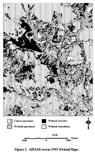
cross-tabulated against the NWI wetness map to quantify wetland and upland map agreement,
plus map disagreement through wetland omission and commission. In addition, analysts
employed visual and quantitative analysis techniques to compare assorted wetness maps with
field survey data (wetland boundary delineations and well sites).
Table 1 lists several GIS-based data processing routines used to produce and/or evaluate the wetness maps for the study. Remote sensing specialists processed each remotely sensed data set into wetness maps by subjecting each raw data set to unsupervised ISODATA classification into 25 spectral clusters. They also prepared an NWI map from 1989 aerial photography by downloading it from the USFWS Internet site, importing it into ArcInfo, and recoding the soil moisture regime into a wetness map. Each classification from remotely sensed data was cross-tabulated with the NWI wetness classification. Analysts recoded spectral cluster classes as wetland or upland depending on what the majority of the cluster class pixels were on the NWI wetness map. To promote classification success, analysts reclassified imaged areas with less than 70% majority value on the NWI map. Then they applied GIS overlay techniques to merge
initial and secondary classifications into a final classification. Each final classification was then
cross-tabulated against the NWI wetness map to quantify wetland and upland map agreement,
plus map disagreement through wetland omission and commission. In addition, analysts
employed visual and quantitative analysis techniques to compare assorted wetness maps with
field survey data (wetland boundary delineations and well sites).
Overall, this project yielded some encouraging results indicating certain kinds of remotely sensed data (particularly AIRSAR imagery) have potential for mapping wetland versus upland areas.
However, these preliminary findings require validation in the form of an intensive, statistically
rigorous map accuracy assessment. The NWI data worked well as a data set for guiding the
production of wetland maps from remotely sensed data but have limitations as an ultimate
reference data set. The available in situ data on wetland boundaries were useful but limited by
the comparatively small sample size and non-random selection of sampling sites. An intensive
accuracy assessment involves laborious field surveys performed by soil scientists and equates to
a significant outlay of cash. Such work is needed to learn more about the nature of agreement
between wetness maps from the NWI and those from remotely sensed data. Perhaps a good
strategy would be to field survey a stratified random sample of wetland versus upland points
from the NWI map. Many GIS software packages have the tools to perform this kind of
operation.
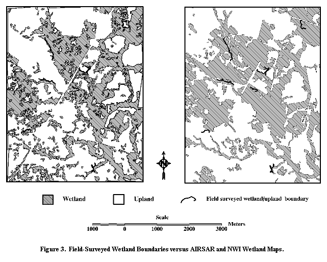
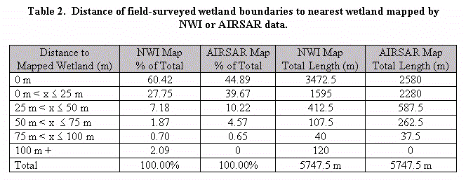
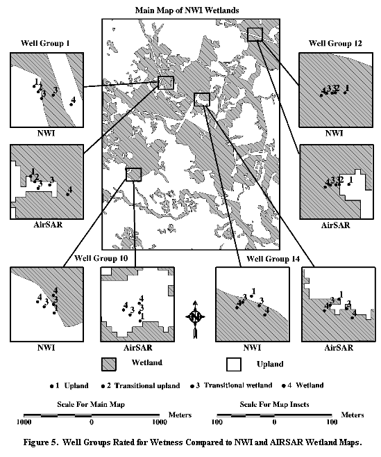
Comparisons of wetness maps with the in situ wetland data indicate both the AIRSAR and NWI wetness maps do not map wetlands to the same level of precision as GPS-based surveys by soil scientists. The results from this study suggest that the AIRSAR and NWI data tend to map wetlands within 50 meters of the field-surveyed wetland boundaries. This level of wetland mapping precision (for the AIRSAR and NWI maps) does not suffice for site-level delineation but can be adequate for regional surveys. GIS analysis also shows that some NWI wetlands are greater than 100 meters from field-measured wetland boundaries. Such anomalies probably indicate wetland omission error. However, a statistically rigorous map assessment is needed to estimate the accuracy of wetland maps from NWI and AIRSAR data. In addition, the wetland mapping approaches used in this study should be tried and evaluated on other kinds of landscapes, such as coniferous forested wetlands in the western United States. Doing so would further validate these wetland mapping technologies.
GIS tools, such as those found in ArcInfo software, proved to be indispensable for quantifying and visualizing comparisons of assorted wetland data. In particular, this study incorporated GIS to generate wetland maps from remotely sensed data and to compare the results to reference NWI maps and in situ wetland boundary data. GISs also assisted in wetness signature evaluation and development by enabling analysts to cross-tabulate unsupervised classifications of remotely sensed data with NWI wetness maps.
Today, the growth in GIS-based functionality has increased the possibilities for using remotely sensed imagery in GIS-based analyses. The analyses for this wetland study benefited immensely from the use of the many raster data processing functions now residing in full-capability GIS systems, such as ArcInfo and ERDAS Imagine. As a result, those working with remotely sensed data are finding that GIS can actually help mapping specialists build and evaluate thematic data sets from remotely sensed data. In addition to full-fledged GIS software, most of the major desktop mapping software packages (e.g., ArcView) now provide functions for incorporating remotely sensed imagery. Also, the amount and kind of commercially available remotely sensed data continue to grow and will do so into the next century. Such developments should help those conducting environmental surveys such as the wetland mapping project described here.