Robert C. Weih, Philip A. Tappe, Chris W. Bennett, Ronald E. Thill
Applying GIS and Remote Sensing to Avian Research: A Case Study on the Ouachita National Forest
Abstract
Phase III of the Ouachita Mountains Ecosystem Management Research study is designed to support operational implementation of ecosystem management at the landscape scale. Four watersheds, from 1,500 to 3,960 hectares, were delineated in the Ouachita National Forest and nearby private industrial forest. To facilitate planning and design of the avian research project, a major component of the study, basic Geographic Information System (GIS) layers such as hydrography, soil types, road and stream locations, elevations, slope, and aspect were developed to characterize the area. In addition, distinct vegetation spectral types were identified based on unsupervised analysis of multi-temporal Landsat TM imagery. After collating the GIS layers, 524 bird census points were established along 72 miles of transect. The transects were positioned to sample many different combinations of vegetation spectral types and physical features of the landscape, as determined by the GIS analysis. All bird census points were then located in the field and their positions recorded with differentially corrected Global Positioning System (GPS) coordinates. Habitat information such as basal area, canopy height, canopy coverage, vegetation density, and vegetation vertical profiles were also measured at each bird census point.
Preliminary first year results showed that a total of 3,201 birds were encountered representing 61 species, of which 31 species were neotropical migrants. Habitat data collected at the 524 bird census points were used along with more current multi-temporal Landsat TM imagery to classify the study area into actual vegetation categories. The spatial arrangement of these categories was used to examine previously over or under sampled areas and to modify bird census points for the 1996 sampling season. In addition, analyses of avian communities as they relate to stand and landscape level habitat parameters were initiated that incorporated the spatial modeling features of GIS.
Introduction
Recent changes in philosophy concerning forest management have focused attention on managing ecosystems at scales beyond the stand level. This emphasis has raised several questions concerning the influence of both individual stand characteristics and forested landscape properties on ecological floral and faunal relationships. Birds are often viewed as indicators of ecosystem health due to their sensitivity to environmental variability (Maurer 1993). Growing evidence suggests that populations of many species of neotropical migratory birds (NTMBs, species that migrate each year between temperate breeding areas and tropical wintering areas) are declining and that these declines have accelerated in recent years (Robbins et al. 1989, Askins et al. 1990, Finch 1991). Factors that have been implicated on their breeding range include habitat destruction/alteration, forest fragmentation, increased predation, and increased nest parasitism by brown-headed cowbirds.
The Ecosystem Management Research Study originated during a field trip by Arkansas Senator David Pryor and USDA Forest Service Chief Dale Roberston in the Ouachita National Forest in 1990. The trip resulted in the elimination of clearcutting in the Ouachita National Forest in favor of other silviculture methods (Mersmann et al., 1994). In 1990, the USDA Forest Service established a three-phase ecosystem research study on the Ouachita National Forest that also included some areas on the Ozark National Forest (Baker, 1994; Wilson and Guldin, 1990). The three-phase study involved researchers, managers, and citizens using the National Forests.
The approach of the first phase (Phase I) was to establish demonstration stands as soon as possible; the second phase (Phase II) was to take a statistical approach at the stand level to look at alternative silviculture treatments; and the third phase (Phase III) was to address questions at a larger watershed scale. Objectives of the Phase III avian research project are to: (1) characterize avian abundance, species richness, and diversity at both the stand and landscape/watershed levels, (2) develop and validate models for predicting breeding season avian community composition (presence/absence and abundance) based on stand-level habitat characteristics and landscape parameters, (3) relate abundance, distribution, and frequency of occurrence of brown-headed cowbirds and avian nest predators (crows and jays) to habitat and landscape characteristics, and (4) establish and collect data from roadside bird survey routes to obtain baseline data for long-term monitoring purposes and compare these data to those obtained from an off-road, stratified sampling design. This paper will describe how GIS and remote sensing technologies have been utilized for planning and designing this study, and how these technologies will be utilized to analyze and interpret data collected throughout the course of this long-term project.
Methods
Study Area
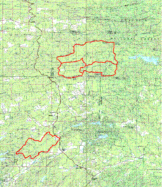
The study area consists of four watersheds (approx. 1,500 - 3,960 hectares) that reflect a range of forest conditions and management intensities that could exist on the Ouachita National Forest. Two watersheds are mostly located within the National Forest (South Alum Creek and Bread Creek), one a mix between National Forest (North Alum Creek) and private ownership, and a fourth is in private ownership (Little Glazpeau). The South Alum Creek watershed (approx. 1,500 hectares) is part of the Alum Creek Experiment Forest which has been unmanaged for several decades; thus, this watershed represents the lowest intensity management level. The Bread Creek watershed (approx. 1,530 hectares) is an Ouachita National Forest primary timber management area, representing an increase in management intensity over the South Alum Creek watershed. About half of the North Alum Creek watershed (approx. 3,960 hectares) is owned by Weyerhaeuser Company and is under intensive high-yield plantations; the other half is publicly owned by the National Forest. Most of the Little Glazypeau (approx. 2,270 hectares) is privately owned and managed by Weyerhaeuser Company, and represents the most intensely managed watershed. The four watersheds are located north of Hot Springs, Arkansas (Figure 1).
Figure 1. Location of the four Phase III watersheds near Hot Springs, Arkansas.
Sampling Design and Planning
To facilitate the planning and design of bird sampling, each watershed was characterized using geographic spatial data in a Geographic Information System (GIS). More than thirty geographic layers of information were developed to assist in sample planning. Basic layers such as hydrography, streams, and road locations were developed from digitizing 1:24,000 USGS quadrangles. Soils and stand boundary layers were obtained from the Ouachita National Forest. Elevation, slope, and aspect information was developed using USGS 30 meter Digital Elevation Models (DEM). Because current delineated vegetation boundaries represent discrete management units and are not necessarily unique vegetation types, multi-temporal (Spring and Fall, 1991) Landsat Thematic Mapper (TM) data was used to develop spectral GIS layers to assist in the sampling design and planning. Bands 2 (0.52 - 0.60 �m), 3 (0.63 - 0.69 �m), 4 (0.76 - 0.90 �m), 5 (1.55 - 1.75 �m), and 7 (2.08 - 2.35 �m) were used in an unsupervised classification to identify unique spectral classes. Geographic layers were developed having 5, 10, 20, 30 and 40 spectral classes. Also, certain wildlife index GIS layers were developed (Patton's Edge Index, etc.) to assist in sampling design and planning.
These GIS layers were used to determine the location of more than 72 miles of transects and 524 plots for the first year measurements. The transect line locations were established to bisect as many spectral and geophysical types as possible within the four watersheds. These transects were mapped and used to establish the transect and plot locations in the field.
Bird Surveys
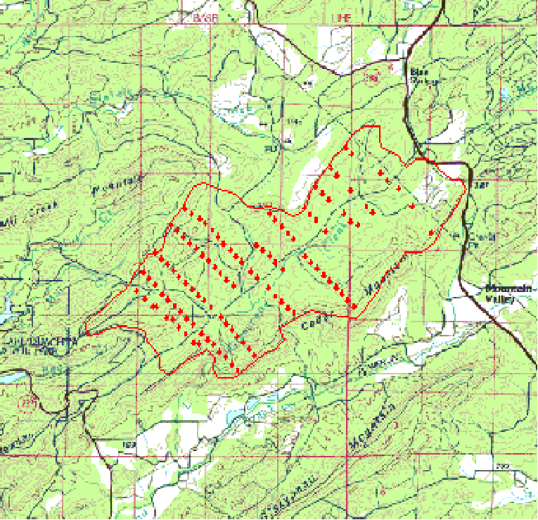
Five hundred twenty-four bird censusing points were established along 72 miles of transects over the four watersheds. Figures 2 and 3 show the Global Position System (GPS) locations of all the bird censusing points. Transects were established and brushed by April 1995. Bird censusing points were spaced approximately 200 meters apart and roughly 75 meters from major roads without regard to habitat type, structure, or proximity to edge. The number of points within each watershed ranged from 75 - 235. Bird censusing plots consisted of a 50-meter radius circle around each point.
Figure 2. A location map of the bird censusing points in the North Alum Creek, South Alum Creek and Bread Creek watersheds.
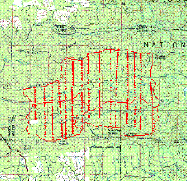
Figure 3. A location map of the bird censusing points in the Little Glazypeau watershed.
Bird surveys were conducted from sunrise to 10:30 hrs with each plot visited by three individuals from May 9 to June 8, 1995. Surveys consisted of individuals walking transects, stopping at each point, and recording birds seen or heard within the plot, respective to number, gender (sight or song), and vocalization (singing or not singing), during a 5-minute sampling period. This was recorded on a bird census data sheet. Birds flying over plots or observed between plots were not included in the census, but their presence was recorded within the watershed. Timing of point surveys and the order in which points where surveyed varied between observes so as to diffuse sampling for a specific point across time of day and season.
Habitat Sampling
Collection of habitat data started in May and was completed by August. Habitat features were quantified at the center of each bird plot and on three 3 meter-subplots located 25 meters from the bird census point. Each subplot was individually marked and arranged as detailed in Figure 4. Location of subplots was adjusted at times to avoid bodies of water.
Figure 4. Habitat sampling scheme for breeding bird census points.
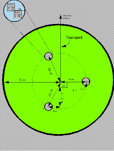
Habitat measurements at the bird census points included slope, aspect and basal area by tree species. Additionally, height, DBH, type (hardwood or conifer), and decay class of snags > 2 meters tall and > 10 cm in d.b.h. that was within 25 meters of the bird census point were tallied. Percent of semi-permanent water (absent only in summer of dry years) covering each bird plot (50 meter radius) was also recorded.
At each subplot habitat structure was assessed by measures of basal area, canopy heights, and canopy coverage for both conifers and hardwoods. Percentage of crown closure was measured at each subplot for both conifers and hardwoods using a spherical densiometer. Heights of residual density and vertical profiles were also recorded for each subplot. Vegetation density and vertical profiles were also recorded for each subplot. Vegetation density was measured at 0.25, 1.25, and 2.25 meters using a density board placed at the center of the subplot and read at 15 meters in direct line with the bird point. Vegetation profiles where taken at four points (90 degrees from one another) around the perimeter of each subplot using a 10 meter extending pole. As the pole was extended the presence or absence of vegetation touching the pole at 1 meter increments up to 10 meter was recorded for conifers and deciduous (including herbaceous) vegetation.
Of the 524 bird survey points, 227 were used to census herpetofauna populations and an additional 26 plots were established as aquatic sites for herpetofauna surveys. Habitat measures at herptofauna plots included the above measures and estimates of ground cover. Two 2 meter by 2 meter quadrants, each containing a 1 meter by 1 meter quadrant was placed in each subplot (Figure 4). Vegetative cover < 1 meter tall was recorded for trees, shrubs, and vines within each 2 meter by 2 meter quadrant. Additionally, percent cover of down wood 1 - 10, 10 - 25, and > 25 cm in diameter was recorded; coverage of 10 - 25 and > 25 cm diameter groups were estimated by decay class. Within each 1 meter by 1 meter quadrant, cover of herbaceous vegetation, rock, moss, bare ground, and litter was estimated. Litter depth was also recorded.
First Year Preliminary Results
A total of 3,201 birds were encountered representing 61 species over the four watersheds. Thirty-one species of neotropical migrants composed 69 percent of the total birds observed in the census. Red-eyed vireos (Vireo olivaceus) were the most common species composing 15.7 percent of all birds sampled followed by Pine warblers (Dendroica pinus) composing 9.8 percent.
The number of neotropical migrants observed within a watershed appeared directly related to intensity of management with South Alum Creek having the fewest birds (220), and Bread Creek (305 birds), North Alum Creek (429 birds), and Little Glazypeau (627 birds) with greater numbers. Pooling the data by watershed, species diversity was calculated for each watershed using the Shannon-Weaver Index. Species diversity was highest on the Little Glazypeau watershed (3.19), followed by North Alum Creek (3.09), Bread Creek (2.82), and South Alum Creek (2.40). Species richness (number of species recorded) exhibited a similar trend with highest richness on the Little Glazypeau watershed (53), followed by North Alum Creek (50), Bread Creek (27), and South Alum Creek (26).
Preliminary statistical analyses of bird populations between watersheds were accomplished by pooling individual observations (n = 3) by plot, and then calculating number of individuals, species richness, and species diversity. The Little Glazypeau watershed had the highest (P < .05) mean number of individuals, species richness, and species diversity per plot for both neotropical migrants and resident birds compared to the other three watersheds. North Alum Creek had more individuals per plot, higher mean species richness, and higher mean diversity compared to Bread Creek and South Alum Creek (P < .05) for neotopical migrants. For resident birds, North Alum Creek, Bread Creek, and South Alum Creek had similar (P > .05) mean number of individuals, species richness, and species diversity per plot.
Results of Integrating Remote Sensing and GIS in Avian Research, Now and in the Future
The GIS layers developed to assist in the sampling design were invaluable in the design and success of initiating a project of this scale. The geographic layers developed for this project provided a solid foundation to insure the success and documentation of all data collected for Phase III of the Ouachita Mountains Ecosystem Management Research study. All data collected in Phase III is linked to GPS geographic coordinates and stored in the GIS. This includes data from the Wildlife, Ecology, Vegetation and Aquatic Research Groups.
Current multi-temporal Landsat TM imagery (February 21, 1995; April 26, 1995: and July 15, 1995) was used along with the 524 vegetation plots to develop a detailed vegetation classification over the four watersheds. The classification is based on linking spectral and geophysical characteristics to canopy vegetation species, basal area by species, percent canopy closure, and understory species composition. This is being used to assist in the establishment of approximate 500 new bird census points in the spring of 1996 and as a base layer to examine spatial relationships between vegetation types and bird species. Also because the road layer was outdated, a new road geographic layer was developed by locating more than 100 miles of roads with a GPS in and around the four watersheds.
In the future analyses will be done using the 30+ geographic layers to measure landscape properties surrounding each bird census plot, as well as across watersheds. Bird data from individual plots will be linked though GPS-obtained coordinates with landscape parameters such as spectral vegetation class size, perimeter, and perimeter/area ratios. Distances from bird census plots to specific habitats (e.g., the nearest mature forest, edge, or riparian area) within the surrounding forest matrix will be computed. Using GIS to buffer around bird census plots, the proportion of different vegetation classes within specific distances of the plots will also be measured. Overall watersheds will be characterized using measures such as mean vegetation class size, perimeter, and perimeter/edge ratios. In addition, sums of induced and inherent edges, and proportions of vegetation classes will be computed. Most of these measures relate to habitat size, isolation, and connectivity, thus serving as indices to habitat fragmentation. Listed below in Table 1 are some of the measures that will be examined.
Table 1. Spatial measures of landscape structure.
_______________________________________________________________
Related to Individual Bird Census Plots
Distance to nearest like vegetation class
Distance to nearest unlike vegetation class
Distance to nearest edge
Distance to nearest riparian edges
Vegetation class size
Vegetation class perimeter
Vegetation class perimeter/area ratios
Perimeter/area fractal dimensions
Proportion of individual vegetation classes within specified distances
Related to Watersheds
Mean distance between like vegetation classes
Mean distance between specific, unlike vegetation classes
Cover by vegetation class size
Mean vegetation class size
Distribution of vegetation class sizes
Mean perimeter/area ratios
Mean perimeter/area fractal dimensions
Mean perimeter length
Mean perimeter length by vegetation class
Contagion
Mean juxtaposition
Mean edge contrast
Richness
Diversity
Evenness
_______________________________________________________________
These analyses will be done using GIS and spatial models currently under development to obtain a better understanding the many relationships that exist in ecosystems in the Ouachita Mountains. The results will provide resource managers with the necessary tools to manage the ecosystem as a whole.
Literature Cited
Askins, R.A., J.F. Lynch, and R. Greenberg. 1990.
- Population declines in migratory birds in eastern North America. Current Ornithology 7:1-57.
Baker, James, B. 1994a.
- An overview of Stand-Level Ecosystem Management Research in the Ouachita/Ozark National Forests. IN: Baker, J. comp. Proceedings of the Symposium on Ecosystem Management Research in the Ouachita Mountains: Pretreatment Conditions and Preliminary Findings. October 26-27, 1993; Hot Springs, AR. Gen. Tech. Rep. SO-112. New Orleans, LA: USDA, Forest Service, Southern Forest Experiment Station. p 18-28.
Baker, James. comp. 1994b.
- Proceedings of the Symposium on Ecosystem Management Research in the Ouachita Mountains: Pretreatment Conditions and Preliminary Findings. October 26-27, 1993; Hot Springs, AR. Gen. Tech. Rep. SO-112. New Orleans, LA: US Dept. of Agriculture, Forest Service, Southern Forest Experiment Station. 259 pp.
Finch, D.M. 1991.
- Population ecology, habitat requirements, and conservation of neotropical migratory birds. U.S. For. Serv. Tech. Rep. RM-205. 26 p.
Maurer, B.A. 1993.
- Biological diversity, ecological integrity, and neotropical migrants: new perspectives for wildlife management. Pages 24-31 In: D.M. Finch and P.W. Stangel, eds. Status and Management of Neotropical Migratory Birds. Gen. Tech. Rep. RM-229. Fort Collins, CO: U.S. Department of Agriculture, Forest Service, Rocky Mountain Forest and Range Experiment Station. 422 p.
Mersmann, Timothy, J., James B. Baker, James M. Guldin, and William F. Pell. 1994.
- Implementing Ecosystem Management Research: Bringing Researchers, Managers, and Citizens Together. IN: Baker, J. comp. Proceedings of the Symposium on Ecosystem Management Research in the Ouachita Mountains: Pretreatment Conditions and Preliminary Findings. October 26-27, 1993; Hot Springs, AR. Gen. Tech. Rep. SO-112. New Orleans, LA: USDA, Forest Service, Southern Forest Experiment Station. p 10-17.
Robbins, C.S., D.K. Dawson, and B.A. Dowell. 1989.
- Habitat area requirements of breeding forest birds of the middle Atlantic states. Wildlife Monograph 103:1-34.
Author Information
Dr. Robert C. Weih, Director of the Spatial Analysis Laboratory
School of Forest Resources, Arkansas Forest Resources Center
University of Arkansas, P.O. Box 3468
Monticello, Arkansas 71656
Telephone: (501) 460-1248
Fax: (501) 460-1092
E-mail: weih@uamont.edu
Dr. Philip A. Tappe, Assistant Professor, Wildlife Ecology and Management
School of Forest Resources, Arkansas Forest Resources Center
University of Arkansas, P.O. Box 3468
Monticello, Arkansas 71656
Telephone: (501) 460-1352
Fax: (501) 460-1092
E-mail: tappe@uamont.edu
Chris W. Bennett, Project Manager at Spatial Analysis Laboratory
School of Forest Resources, Arkansas Forest Resources Center
University of Arkansas, P.O. Box 3468
Monticello, Arkansas 71656
Telephone: (501) 460-1292
Fax: (501) 460-1092
E-mail: bennett@uamont.edu
Dr. Ronald E. Thill, Project Leader/Research Wildlife Biologist
Wildlife Habitat & Silviculture Laboratory, USFS
Box 7600 SFA Station
Nacogdoches, Texas 75962
Telephone: (409) 569-7981
Fax: (409) 569-9681
E-Mail: s=r.thill/ou1=s30a@mhs-fswa.attmail.com